
Posts Tagged ‘Coastal Global Scale Nodes’
Spreading Curiosity about Ocean Science with Summer Visitors
Summertime brings students from all over the country to Woods Hole, Massachusetts to learn about ocean science. June and July 2023 were particularly busy, with the Coastal and Global Scale Nodes (CGSN) division of the Ocean Observatories Initiative (OOI) at Woods Hole Oceanographic Institution (WHOI) hosting four different student groups. CGSN offers student tours of OOI facilities and the chance to talk directly with an ocean scientist or engineer. They engage with students this way in the hope of increasing student interest in marine science and possibly encouraging them to pursue an ocean-related career. During the tours and presentations, students learn about the moorings and vehicles OOI deploys throughout the year and the dissemination of ocean data collected. These hands-on experiences give student visitors the opportunity to see the full scale and complexity of OOI operations.
UMass-Dartmouth REU Students Visit
On June 26, 12 community college engineering student and faculty from a National Science Foundation (NSF) sponsored Research Experience for Undergraduate (REU) at the University of Massachusetts, Dartmouth (UMass-Dartmouth) visited OOI. CGSN staff provided a tour of their operations, including ocean-observing equipment stored outdoors because of its size.
[media-caption path="https://oceanobservatories.org/wp-content/uploads/2023/07/Sheri-with-REUs.jpg" link="#"]CGSN team members, Dr. Sheri White (blue jeans to right) and Irene Duran (next to Dr. White) gave a tour to UMass-Dartmouth REU students. Photo by: Kama Theiler © WHOI.[/media-caption] [media-caption path="https://oceanobservatories.org/wp-content/uploads/2023/07/Colin-Dobson-with-REU.jpg" link="#"]A UMass-Dartmouth REU student asks CGSN glider expert Colin Dobson a question regarding the gliders he works on. Photo by: Kama Theiler © WHOI.[/media-caption]PEP Students Visit
In early July, the CGSN team gave a presentation to Woods Hole Partnership Education Program (PEP) participants, who spend 10-weeks in Woods Hole at WHOI, the Marine Biological Laboratory, Woodwell Climate Research Center, National Oceanic and Atmospheric Administration’s Northeast Fisheries Science Center, Sea Education Association, or the United States Geological Survey’s Woods Hole Coastal and Marine Science Center. The PEP program is designed primarily for college juniors and seniors from underrepresented groups in marine and ocean sciences who want to spend a summer gaining practical experience in marine and environmental science.
Summer 2023 is the 15th summer of the PEP program in Woods Hole. Many former PEP students have returned to Woods Hole and WHOI both as students and professionals (including CGSN’s Irene Duran). Benjamin Harden, PEP professor, stated that OOI’s community outreach is a “great way for these students to hear about the frontiers of oceanography and really helped many of them frame possible careers in the field.”
Black Girls Dive Foundation Visit
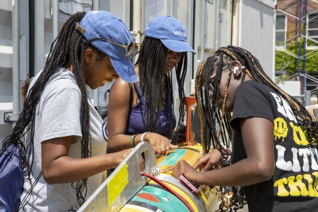
July 25th, CGSN’s Electrical Team provided a workshop to the Black Girls Dive Foundation (BGDF) program participants. BGDF provides the space and opportunity to empower young black women to explore their STEM (Science, Technology, Engineering and Mathematics) identity through marine science and conservation, and SCUBA diving. While visiting OOI, the BGDF students learned about pH and concerns about increasing ocean acidification. The students collected local sea water and with the help of the CGSN Instrument Team determined its pH with a probe they calibrated using a microcontroller.
[media-caption path="https://oceanobservatories.org/wp-content/uploads/2023/07/BGDF-with-AUV.jpg" link="#"]During their visit to WHOI, BGDF students had the opportunity to get up close to check out an Autonomous Underwater Vehicle (AUV). Photo by: Jayne Doucette © WHOI.[/media-caption] [media-caption path="https://oceanobservatories.org/wp-content/uploads/2023/07/Jennifer-with-BGDF.jpg" link="#"]CGSN Instrument Lead Jennifer Batryn (far left) shows how she checks OOI instruments operations on her laptop to one of the BGDF visitors. Photo by: Jayne Doucette © WHOI.[/media-caption]SEA Participants Visit
Also in late July a group of students participating in the Sea Education Association’s (SEA’s) High School program visited OOI’s Facility LOSOS on WHOI’s Quissett Campus. This is a study abroad program in Woods Hole for undergraduate, gap year, and high school students, that combines studies in ocean science with at-sea experiences. The students spent an afternoon learning about OOI, its operations, how data are collected and disbursed, and what scientists are learning from OOI data.
[media-caption path="https://oceanobservatories.org/wp-content/uploads/2023/07/Dee-and-Jon-With-SEA-students-2.jpg" link="#"]CGSN team members Dee Emrich (standing left) and John Lund explained OOI operations to high school students from the Sea Education Program. Photo by: Dr. Sheri White © WHOI.[/media-caption] [media-caption path="https://oceanobservatories.org/wp-content/uploads/2023/07/Irene-with-SEA-students.jpg" link="#"]CGSN Engineer Irene Duran (maroon top in center) showed mooring components to high school students from the Sea Education Program. Photo by: Paul Whelan © WHOI.[/media-caption] Read MoreThe Great Salinity Anomaly of 2015-2020
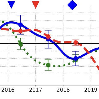
The Great Salinity Anomaly of 2015-2020. Adapted by OOI from Biló et al., 2022.
[media-caption path="https://oceanobservatories.org/wp-content/uploads/2023/07/Bilo-.png" link="#"]Figure: Time series of salinity anomalies from OSNAP moorings near the Reykjanes Ridge (RR) and within the western boundary current of the Irminger Sea (CF6), and from OOI Flanking Mooring (FLB) in the Irminger Sea (FLB). The eighteen-month low-passed anomalies are averaged between 0 and 200 m depth and computed relative to the mean of the moored data record. Error bars show 95% confidence intervals for annual salinity averages. The blue (red) triangles and diamonds represent the start and end of the freshening period in the CF6 (FLB) records, respectively.[/media-caption]Unusual surface freshening episodes in the Subpolar North Atlantic have been documented since the 1960s when the term Great Salinity Anomaly (GSA) was coined to refer to the first documented event (Dickson et al., 1988). GSAs are of great importance because the reduction in surface density of North Atlantic surface waters increases vertical stratification, suppresses deep water formation, and weakens the Atlantic Meridional Overturning Circulation (AMOC). Deep (700-1000 m) wintertime convection in the Irminger and Labrador Seas creates the water mass constituting the northern portion of the AMOC’s lower limb, which transports cold water back to southern latitudes. Thus, sustained changes to deep water formation due to a GSA will impact the global climate system.
New work by Bilo et al. (2022) argues that there has been another GSA during 2015-2020, with significant salinity reduction in the upper 200 m of the Iceland Basin and Irminger Sea. The authors use hydrographic data and moored observations to document the spatial extent and propagation pathways of the GSA.
Hydrographic data come from the Argo float monthly climatology and from UK Met Office Hadley Centre “enhanced” version 4 (EN4) historical hydrography. These spatial data sets allow the basin-wide salinity changes to be diagnosed, and show that between 2015 and 2020 the upper 200 m of the central Irminger Sea freshened by 0.1-0.2 PSU. The observed freshening rate of up to 0.04 PSU per year is among the fastest salinity decreases ever recorded in the region. The regional maps show the freshening first in the Iceland Basin and later in the Irminger Sea.
Moored observations come from the Overturning in the Subpolar North Atlantic Program (OSNAP) and from the OOI Irminger Sea Array. Two OSNAP moorings are evaluated, one on the eastern side of the Irminger Sea near the Reykjanes Ridge and one on the western side within the southward-flowing boundary current. OOI Flanking Mooring B was used to represent conditions in the central Irminger Sea. The results (Figure above) show a salinity minimum near the Reykjanes Ridge in 2017 followed by a minimum at the western boundary in 2018 and finally a significant (~0.1 PSU) salinity reduction in the Irminger Sea interior in 2019. Estimated transit times from the mooring data indicate that the salinity signal is advected quickly (months) by Irminger Sea boundary currents after crossing the Reykjanes Ridge and then spreads more slowly to the interior, taking of order two years to impact the central Irminger Sea.
The authors note that although climatologies are important to determine regional changes, these data are mostly limited to deep water. Moorings can provide data within the boundary currents, as well as well-resolved temporal evolution at multiple locations. This underscores the importance of a hybrid ocean observing system combining historical climatologies, broad spatial coverage (Argo), and time series data (OSNAP, OOI).
_______________________________________________
Biló, T.C., F. Straneo, J. Holte and I. Le Bras, (2022). Arrival of new Great Salinity Anomaly weakens convection in the Irminger Sea. Geophysical Research Letters, 49, e2022GL098857, doi:10.1029/2022GL098857.
Dickson, R.R., J. Meincke, S.-A. Malmberg, and A.J. Lee (1988). The great salinity anomaly in the Northern North Atlantic 1968–1982″. Progress in Oceanography, 20 (2): 103–151, doi:10.1016/0079-6611(88)90049-3.
Read MoreNew OOI Coastal Surface Mooring Design
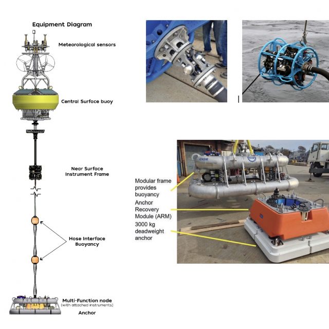
The OOI Coastal Surface Moorings (CSMs) showcase a variety of innovative mooring technologies. Although the design concepts were initially developed as elements of other mooring systems, they were brought together for the first time on the OOI CSM. A recent paper by Peters et al. (2022) describes three areas where new design concepts were particularly impactful: (1) components at the interface between the surface buoy and mooring riser, (2) mooring riser components, and (3) an integrated seafloor anchor and instrument frame. These components work together to provide mechanical integrity for the mooring as well as mounting points for instrumentation and a reliable electrical pathway for the transmission of power from the surface to the seafloor and data from the seafloor to the buoy (Figure above).
Components comprising the buoy-to-riser interface include a universal joint, an electro-mechanical (EM) chain, and a Near Surface Instrument Frame (NSIF). The universal joint, at the buoy base, reduces the translation of buoy pitch and roll motion into bending moments at the top of the mooring riser. The EM chain, a conventional chain wrapped with helically-wound conductors and encapsulated in urethane, provides a flexible strength member between the buoy and the NSIF. The NSIF provides a mounting point for instruments and a mechanical transition from the EM chain to the EM cable.
Components along the mooring riser include the EM cable, EM stretch hoses, and distributed buoyancy elements between stretch hoses. The EM cable employs a wire rope strength member mechanically terminated with a swaged fitting. A molded urethane strain relief boot at the upper end of the cable interfaces with the NSIF bellmouth. The lower termination assembly provides strain relief and a cavity for integration of underwater connectors. The EM stretch hoses were initially developed in the 1990s by WHOI engineer Walter Paul. A novel, multi-layer construction technique was developed for OOI to enable a 24-conductor stretch hose. Hose lengths from 9 to 30 m are employed on OOI moorings. Each hose has a breaking strength of over 10,000 lb and stretches to over twice its original length to provide variable mooring scope and reduction of peak dynamic loads.
At the buoy base is an integrated anchor and instrument frame assembly called the Mult-Function Node (MFN). The MFN frame is a buoyant structure made of air-filled aluminum pipe, configured to allow the mounting of instruments, data loggers and batteries. The MFN is weighted to the seafloor with an anchor assembly that sits in the center of the frame, connected with dual acoustic releases. The anchor assembly consists of a flat-plate anchor below a foam buoyancy element that contains an internal spool with several hundred meters of synthetic line. The buoyancy element is connected to the anchor with dual acoustic releases. This system allows for mooring and anchor recovery in three stages: First, the MFN is separated from the anchor and the mooring riser is recovered. Next, the buoyancy element is released from the anchor allowing it to rise to the surface while offspooling line. Finally, the anchor is hauled using the synthetic line.
This unique combination of design elements creates a mooring system capable of housing and powering complex instrument systems, transmitting data in near real-time, and contributing to the long-term reliability of the OOI Coastal Surface Moorings in the challenging environment of the continental shelf.
Peters, D.B, J.N. Kemp and A.J. Plueddemann (2022). Coastal Surface Mooring Developments for the Ocean Observatories Initiative (OOI). Marine Technol. Soc. J., 56(6), 70-74. doi.org/10.4031/MTSJ.56.6.2.
Read MoreA Case Study for Open Data Collaboration
Recognizing that freely accessible ocean observatory data has the potential to democratize interdisciplinary science for early career researchers, Levine et al. (2020) set out to demonstrate this capability using the Ocean Observatories Initiative. Publicly available data from the OOI Pioneer Array moorings were used, and members of the OOI Early Career Scientist Community of Practice (OOI-ECS) collaborated in the study.
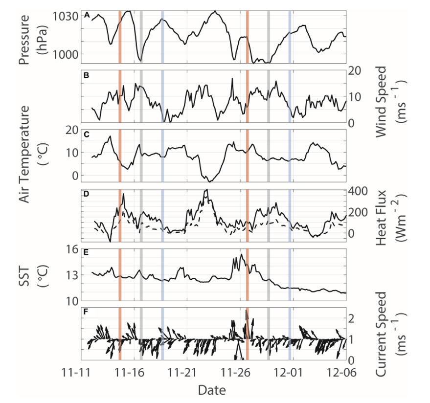
A case study was constructed to evaluate the impact of strong surface forcing events on surface and subsurface oceanographic conditions over the New England Shelf. Data from meteorological sensors on the Pioneer surface moorings, along with data from interdisciplinary sensors on the Pioneer profiler moorings, were used. Strong surface forcing was defined by anomalously low sea level pressure – less than three times the standard deviation of data from May 2015 – August 2018. Twenty-eight events were identified in the full record. Eight events in 2018 were selected for further analysis, and two of those were reported in the study (Figure 24).
[media-caption path="https://oceanobservatories.org/wp-content/uploads/2021/07/CGSN-Highlight.png" link="#"]Figure 24. Two surface forcing events (16 and 27 November) identified from the time series of surface forcing at the Pioneer Central surface mooring. Vertical lines indicate the peak of the anomalous low-pressure events (gray), as well as times 48 h before (red) and after (blue). (A) sea level pressure, (B) wind speed, (C) air temperature, (D) latent (solid) and sensible (dashed) heat fluxes, (E) sea surface temperature, and (F) surface current speed and direction. [/media-caption]The impact of surface forcing on subsurface conditions was evaluated using profile data near local noon on the day of the event, as well as 48 hr before and after (Figure 24). Subsurface data revealed a shallow (40-60 m) salinity intrusion prior to the 16 November event, which dissipated during the event, presumably by vertical mixing and concurrent with increases in dissolved oxygen and decreases in colored dissolved organic matter (CDOM). At the onset of the 27 November event, nearly constant temperature, salinity, dissolved oxygen and CDOM to depths of 60 m were seen, suggesting strong vertical mixing. Data from multiple moorings allowed the investigators to determine that the response to the first event was spatially variable, with indications of slope water of Gulf Stream origin impinging on the shelf. The response to the second event was more spatially-uniform, and was influenced by the advection of colder, fresher and more oxygenated water from the north.
The authors note that the case study shows the potential to address various interdisciplinary oceanographic processes, including across- and along- shelf dynamics, biochemical interactions, and air-sea interactions resulting from strong storms. They also note that long-term coastal datasets with multidisciplinary observations are relatively few, so that the Pioneer Array data allows hypothesis-driven research into topics such as the climatology of the shelfbreak region, seasonal variability of Gulf Stream meanders and warm-core rings, the influence of extreme events on shelf biogeochemical response, and the influence of a warming climate on shelf exchange.
In the context of the OOI-ECS, the authors note that the study was successfully completed using open-source data across institutional and geographic boundaries, within a resource-limited environment. Interpretation of results required multiple subject matter experts in different disciplines, and the OOI-ECS was seen as well-suited to “team science” using an integrative, collaborative and interdisciplinary approach.
______________________________________________________________________________________________
Levine, RM, KE Fogaren, JE Rudzin, CJ Russoniello, DC Soule, and JM Whitaker (2020) Open Data, Collaborative Working Platforms, and Interdisciplinary Collaboration: Building an Early Career Scientist Community of Practice to Leverage Ocean Observatories Initiative Data to Address Critical Questions in Marine Science. Front. Mar. Sci. 7:593512. doi: 10.3389/fmars.2020.593512.
Read MoreEasing Sharing of Glider Data
The OOI’s Coastal and Global Array teams regularly use Teledyne-Webb Slocum Gliders to collect ocean observations within and around the array moorings. The gliders fly up and down the water column from the surface down to a maximum depth of 1000 meters, collecting data such as dissolved oxygen concentrations, temperature, salinity, and other physical parameters to measure ocean conditions.
OOI shares its glider data with the Integrated Ocean Observing System (IOOS) Glider Data Assembly Center (DAC). IOOS serves as a national repository for glider data sets, serving as a centralized location for wide distribution and use. It allows researchers to access and analyze glider data sets using common tools regardless of the glider type or organization that deployed the glider.
OOI serves data to these repositories in two ways. When the gliders are in the water, data are telemetered, providing near real-time data to these platforms. Once the gliders are recovered, data are downloaded, metadata provided, and data are resubmitted to the Glider DAC as a permanent record.
The behind-the-scene process transmitting this huge amount of data is quite complex. OOI Data Team members, Collin Dobson of the Coastal and Global Scale Nodes at Woods Hole Oceanographic Institution (WHOI) and Stuart Pearce of the Coastal Endurance Array at Oregon State University (OSU) teamed up to streamline the process and catch up on a backlog of submission of recovered data.
Pearce took the lead in getting the OOI data into the DAC. In 2018, he began writing code for a system to transmit near real-time and recovered data. Once the scripts (processing code) were operational by about mid-2019, Pearce implemented them to streamline the flow of Endurance Array glider data into the DAC. Dobson then adopted the code and applied it to the transmission of glider data from the Pioneer, Station Papa, and Irminger Sea Arrays into the repository.
As it turned out, timing was optimum. “ I finished my code at the same time that the Glider DAC allowed higher resolution recovered datasets to be uploaded,” said Pearce. “So I was able to adjust my code to accommodate the upload of any scientific variable as long as it had a CF compliant standard name to go with it.” This opened up a whole range of data that could be transmitted in a consistent fashion to the DAC. CF refers to the “Climate and Forecast” metadata conventions that provide community accepted guidance for metadata variables and sets standards for designating time ranges and locations of data collection. Dobson gave an example of the name convention for density: Sea_water_density.
“Being CF compliant ensures your data have the required metadata and makes the data so much more usable across the board,” added Dobson. “If I wanted to include oxygen as a variable, for example, I have to make sure to use the CF standard name for dissolved oxygen and report the results in CF standard units.”
The Endurance Array team was the first group to add any of the non-CTD variables into the Glider DAC. This important step forward was recognized by the glider community, and was announced at a May 2019 workshop at Rutgers with 150 conveyors of glider data in attendance. One of Pearce’s gliders was used as the example of how and what could be achieved with the new code.
To help expedite the transfer of all gliders into the DAC, Pearce made his code open access. The additional metadata will help advance the work of storm forecasters, researchers, and others interested in improving understanding ocean processes.
Read More
Irminger Sea Intermediate Water Formation and Transport
Adapted and condensed by OOI from Le Bras et al., 2020, doi:/10.1029/2019GL085989.
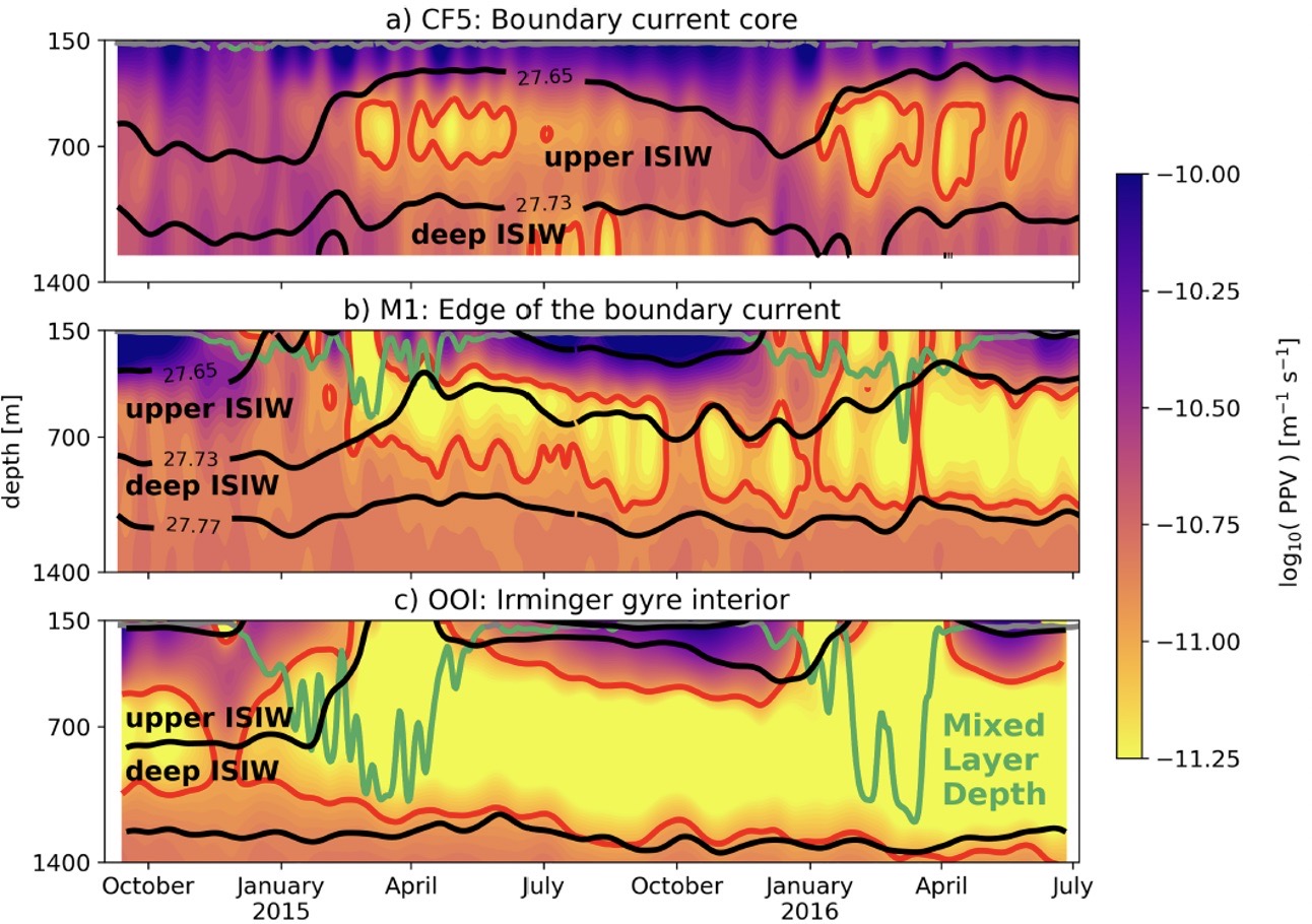
[caption id="attachment_18947" align="aligncenter" width="640"] Figure 19. Planetary potential vorticity (PPV) at (a) OSNAP mooring CF5, within the Irminger Sea boundary current core (b) OSNAP mooring M1, at the edge of the boundary current and (c) OOI flanking mooring (FLMA) and Surface Mooring within the Irminger Sea gyre. From Le Bras et al. (2020).[/caption]
A two-year record from moorings in the Irminger Sea allowed researchers (Le Bras et al., 2020) to investigate both deep convection and transport of water masses associated with the Atlantic overturning circulation. Using mooring data from the OOI Irminger Sea Array and the Overturning in the Subpolar North Atlantic (OSNAP) array, the authors were able to identify two types of Irminger Sea Intermediate Water (ISIW) formed by deep convection. Upper ISIW is found near the edge of the Irminger Sea western boundary current, whereas Deep ISIW is formed in the basin interior. Water masses were diagnosed using temperature-salinity properties and the planetary potential vorticity (PPV). Figure 19 shows PPV for three different locations, in the boundary current, at its edge, and in the Irminger Sea gyre. Black lines in the figure indicate the isopycnals that bound upper and deep ISIW as defined by the authors, the red contours enclose water with low PPV (indicative of convection) and the green lines indicate the mixed layer depth.
Seasonal pulses of low PPV water in the boundary current occurring below the mixed layer (Figure 19a) suggest subduction from a non-local source offshore. In contrast, low PPV water in the gyre interior is accompanied by a deep winter mixed layer and appears related to local convection. Further analysis by the authors indicates that waters formed by convection in the interior gyre are entrained into the boundary current within a few months of formation. Importantly, it appears that eddy dynamics are responsible for this transport of ventilated water from the interior to the boundary, and that the upper ISIW in the boundary current is a significant component of the Atlantic overturning circulation.
Read More