
Posts Tagged ‘Coastal Pioneer Array’
First Deployment of the Pioneer Array in the MAB
At 0900 Eastern on Monday April 1, 2024, the R/V Neil Armstrong will back out of the dock at Woods Hole, MA to begin the transit to the new location of the U.S. National Science Foundation (NSF) Ocean Observatories Initiative (OOI) Coastal Pioneer in the Mid-Atlantic Bight (MAB). This promises to be a momentous trip for it will be the first deployment of the Pioneer in the MAB, a location decided upon after a series of NSF-sponsored meetings with community users of OOI data. The expedition also will mark the 20th Pioneer deployment undertaken by the Coastal and Global Scale Nodes (CGSN) team at Woods Hole Oceanographic Institution (WHOI).
“The array is design to provide data to help scientists better understand the dynamics of the region, the role of biogeochemical cycling and transport, and the impact of extreme events like hurricanes and freshwater outflows,” said Albert Plueddemann, chief scientist for this first deployment and lead scientist of the CGSN group. “There’s already considerable community interest in obtaining data from the OOI infrastructure and leveraging the array installation for research and testing. Once the array is in place, we anticipate even more interest, and look forward to engaging with researchers in the region.”
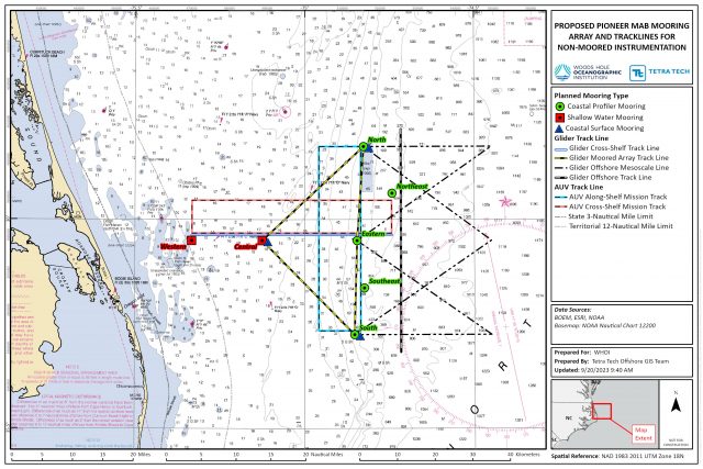
The Pioneer MAB is a T-shaped array with moorings, located offshore of Nags Head, North Carolina, at depths of 30-300 meters and nominal spacing of15-25 kilometers. The array will consist of ten platforms at seven different sites – two platforms will be deployed as adjacent pairs at three sites. The platforms include three surface moorings, five profiler moorings, and two shallow-water moorings. The Pioneer MAB will also have mobile assets—four coastal gliders and two autonomous underwater vehicles (AUVs). These mobile assets will traverse the water column along different track lines to give a fuller, more robust picture of water column properties.
[media-caption path="https://oceanobservatories.org/wp-content/uploads/2024/03/MAB-Array-map-3-scaled.jpg" link="#"]Figure 1: Location of moorings of the Coastal Pioneer Array in its new location in the Mid-Atlantic Bight.[/media-caption]After a ~36-hour transit to the site, the team of 15 scientists and engineers will get to work to deploy the new array. Because of the large size of the moorings, the expedition will be conducted in two legs and be completed on April 22nd. In addition to the mooring and mobile asset deployments, the team will be conducting CTD (to measure conductivity, temperature, and depth) casts with water sampling at the deployment sites. In addition, they will be making ship vs meteorological comparisons at the surface mooring sites to ensure the rigor and accuracy of meteorological measurements. They also will be conducting some shipboard underway surveys, as well as a bathymetric survey to gain a complete picture of the new location.
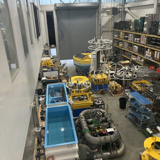
[media-caption path="https://oceanobservatories.org/wp-content/uploads/2024/03/IMG_0550-2-scaled.jpg" link="#"]A lot of equipment is at the ready! Northern and Southern Coastal Surface Moorings, along with seabed multi-function nodes and near-surface instrument frames, as they were being assembled. The team integrates the science instrumentation with the mechanical/power/telemetry/data systems, then tests the system before loading on the vessel. Credit: Derek Buffitt © WHOI.[/media-caption]Continuing the tradition of the Coastal Pioneer Array off the New England Shelf, this first deployment expedition will be a collaborative one. A marine mammal observer from the National Oceanic and Atmospheric Administration will be onboard to count marine mammals in the region. A representative from the Northeast U.S. Shelf Long-Term Ecological Research (NES-LTER) will be onboard to conduct sampling from CTD casts and flow cytometers, which can analyze the characteristics of cells found in water as the ship is underway. This will be a continuation of an ongoing collaboration for the past seven years. And a Department of Energy representative will also be onboard as tests are conducted to determine the viability of placing a wave energy conversion device on the array.
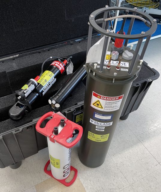
Along with being the first deployment in the Southern Mid-Atlantic Bight, the Pioneer MAB Array will also include new instrumentation on the three Surface Moorings. The new instrumentation includes plankton imaging sensors (the McLane IFCB), instruments that measure particle size distribution (the Sequoia LISST-200X), short-range velocity profile instruments for the upper water column (the Nortek Aquadopp Profiler-S1VP), turbidity sensors (the Sea-BIrd ECO), and new seafloor pressure sensors (the RBR Quartz3QPlus). These were among the measurements recommended during the National Science Foundation OOI Facility Board community workshops in 2021 to select a new location for the Pioneer Array.
[media-caption path="https://oceanobservatories.org/wp-content/uploads/2024/03/IMG_0554-2-scaled.jpg" link="#"]Sheri White and Nikki Arm prepare and bench test the new Imaging Flow CytoBot, also known as a Plankton Imaging System (PLIMS), that will be deployed on the Central Surface Mooring of the new Pioneer MAB array. The PLIMS generates images of the particles in the local aquatic environment. Credit: Derek Buffitt © WHOI.[/media-caption]
Read More
National Lab Researchers Working on Wave Energy Converter for Pioneer
The Water Power Technologies Office of the US Department of Energy’s Office of Energy Efficiency and Renewable Energy announced that Sandia National Laboratories, in partnership with Woods Hole Oceanographic Institution, is working to develop a wave energy converter (WEC) that can support the Coastal Pioneer Array, one of five arrays that make up the U.S. National Science Foundation Ocean Observatories Initiative.
The WEC will serve the Coastal Surfacing Mooring (CSM) system, which currently relies on solar, wind, and battery systems to power multiple sensors on the buoy itself and along the mooring line. These existing energy resources meet the system’s full power demand about 70% of the time. To satisfy the full power demand 100% of the time and prevent interruptions to data streams, Sandia has been investigating designs for WECs that could provide additional electrical power to the CSM.
Read more here.
Read MorePioneer MAB Array Workshop Applications


Old Dominion University, Norfolk, VA
The Ocean Observatories Initiative Facility Board (OOIFB) will host a community workshop focusing on current and future initiatives that can be addressed using data from the National Science Foundation’s (NSF) OOI Coastal Pioneer Array, which is planned to be relocated to the Southern Mid-Atlantic Bight. The workshop will be held at the Webb University Center, Old Dominion University, in Norfolk, VA, on September 10-12, 2024.
The event will bring together a diversity of scientists, resource managers, educators, and other stakeholders to learn about the capabilities of the Coastal Pioneer MAB Array and the cutting-edge research that can be done in this new location. The workshop also will provide a forum to facilitate cross-network collaborations, identify strategies for better engaging current and future users of the NSF’s OOI, and foster the research and proposal development process. NSF OOI Program team members and NSF representatives will be on hand to answer questions and provide information on NSF OOI operations.
Researchers who are using or are considering using NSF OOI data; resource managers from national, state, and tribal agencies; and educators at all levels interested in using data from the NSF OOI Coastal Pioneer MAB Array are encouraged to participate in this community workshop. To apply for the workshop, please complete the online application form that is available on the workshop web page. Travel support is available, but limited. Broad representation from institutional, geographic, and disciplinary groups is desired and will be considered in participant selection. The deadline for applications is March 26, 2024.
Additional details about the workshop and agenda are available here. If you have any questions, please be in touch.
Coastal Pioneer MAB Community Workshop
Instrumentation Updates for Planned Pioneer MAB Array
Community Input
The Ocean Observatories Initiative Facilities Board (OOIFB), sponsored by the National Science Foundation (NSF) and in partnership with KnowInnovations, facilitated two community workshops, called Innovations Labs, that resulted in the decision to relocate the Pioneer Array to the southern Mid-Atlantic Bight (MAB). The second Lab included community input on measurements that would be desirable for the relocated array. More than 40 instruments or measurement types were discussed. This was reduced to about a dozen high-priority recommendations based on consensus among the Innovations Lab sub-groups. After considering applicability to the science themes, technical readiness level, operational feasibility, and budget impacts the OOI Program was able to implement the majority of the high-priority recommendations.
Among the goals for the relocation process was to optimize the use of existing inventory, and it was possible to do so while addressing several of the instrumentation recommendations. In some cases, new procurements were required, although it should be noted that one of these procurements was needed to replace an obsolete core sensor. A summary of the instrumentation updates for the proposed Pioneer MAB relocation in these two categories is provided below.
Repurposing of Existing Core Instruments
The OOI deploys a set of core instruments across all the Arrays. Reconfiguration of the Pioneer Array elements, along with some inventory available from the decommissioned southern hemisphere arrays, meant that some instrumentation could be repurposed for the Pioneer MAB Array without requiring new purchases. Five instrumentation changes were made using this approach:
- Near-surface temperature and salinity: A Seabird SBE-37 CTD will be mounted on the “foot” of the five Coastal Profiler Mooring (CPM) buoys.
- Incident radiation: A Sea Bird OCR-507 multispectral radiometer will be mounted on the tower of the three Coastal Surface Mooring (CSM) buoys. This instrument will measure downwelling radiation per unit area.
- Surface wave spectra: A TriAxys Next Wave sensor will be added to the buoy well of all three CSMs. These sensors, which provide both non-directional and directional wave parameters, were previously deployed on only the Central CSM for the Pioneer NES.
- Turbidity: Seabird ECO triplet instruments with a secondary turbidity calibration on the optical backscatter channel will be deployed on the Near Surface Instrument Frame (NSIF) and seafloor Multi-Function Node (MFN) of the three CSMs.
- Nitrate: A glider with a Sea-Bird SUNA nitrate sensor will be deployed on the offshore “flux line”.
New Procurements
Several of the high-priority recommendations from the Innovations Labs that were deemed feasible for implementation required instrumentation that was not part of the OOI core. In this case, a formal procurement process is required (the process for replacing an obsolete sensor is similar). Four measurements required new instrument procurements: Near-surface velocity, phytoplankton imagery, particle size, and seafloor pressure. The procurement process for these instruments was initiated in November 2022.
The procurement process involves multiple steps of specification, information collection, review and approval before actual purchases are made. Among the first set of steps executed for the Pioneer MAB procurements were: consultation with a Focus Group of scientists external to the OOI, development of measurement specifications and revision of requirements as needed. The specifications were then used to create a solicitation of information from vendors through a broadly disseminated Request For Information (RFI). The RFI responses were reviewed by a selection committee composed of both internal and external subject matter experts, who evaluated instrument and vendor capabilities relative to performance specifications, technical feasibility, cost, and other factors. Additional steps included Design Reviews and Selection Reviews where the documentation of the process is presented to the Program Management Office and the NSF. After approval of vendor selection from the Review steps, orders were placed for the new equipment.
The Program is currently pursuing the procurement of four instrument classes, with 15 instances to be deployed at different locations within the Pioneer MAB Array (Table 1). Instrument locations include the buoy, Nearshore Instrument Frame (NSIF) and Multi-Function Node (MFN) on the Coastal Surface Moorings, and the buoy and buoyancy sphere of the Coastal Profiler Moorings.
Table 1: New Instrument Procurements for Pioneer MAB
| Measurement | OOI Code | Make/Model | Location | Instances |
| Near-surface velocity profile | ADCPU | Nortek Aquadopp profiler 1MHz | Coastal Profiler Mooring Sphere | 5 |
| Plankton Imaging | PLIMS | McLane Imaging Flow CytoBot | Coastal Surface Mooring Central site NSIF | 1 |
| Particle Size Analysis | PRTSZ | Sequoia LISST-200X | Coastal Surface Mooring NSIF and MFN | 6 |
| Seafloor Pressure | PRESF | RBR Quartz3Qplus | Coastal Surface Mooring MFN | 3 |
More information on the proposed relocation of the Pioneer Array to the Mid-Atlantic Bight is available here.
Read More
Pioneer Student Boat Crossed Atlantic 3X
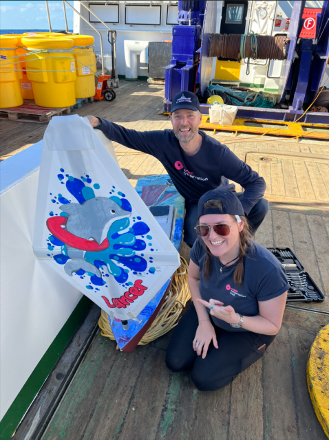
Seven years ago, the scientists and crew on the research vessel Neil Armstrong released a mini boat built by students at Quaker Elementary School and Waterford High School in Waterford, Conn. Earlier this year, the Lancer mini boat completed its crossing of the Atlantic. The boat’s third voyage started in December 2022, off the coast of Tenerife, Spain, and ended in The Bahamas on Earth Day, April 22, 2023.
The boat was made from a kit in 2016, made multiple ocean crossings and was highlighted on a BBC2 Documentary. This remarkable journey and story will be celebrated in a 30-minute webinar, December 18 at 8 am, including highlighting the contributions of many who helped along the way. It is free and open to the public with registration here. For those who missed the webinar live, you can view it here.
[media-caption path="https://oceanobservatories.org/wp-content/uploads/2023/12/Screenshot-2023-12-18-at-11.04.07-AM.png" link="#"]The Lancer was launched on from the R/V Neil Armstrong for its first trans-Atlantic crossing on May 7, 2016. Credit: Ken Kostel © WHOI.[/media-caption]This science project, started by a student named Kaitlyn in 2016, has since connected individuals across five countries. The Lancer and sister ships are part of Educational Passages, with a mission of connecting people around the world to the ocean and each other through unique global experiences such as their mini boat program. Students build the mini boats that drift with currents and follow their progress using GPS.
In November 2022, the Pioneer 19 team and crew of the R/V Neil Armstrong launched a sister ship and drifter, Lady Lance. This boat was recovered in the Azores in May 2023.
[media-caption path="https://oceanobservatories.org/wp-content/uploads/2023/12/lancer_OCT.png" link="#"]The student-built drifter mini boat Lancer was recovered in the Bahamas after its third Atlantic voyage. Credit: Educational Passages. [/media-caption]Read More
Another Round of Pioneer MAB At-Sea Tests Completed
A team of OOI Coastal and Global Scale Nodes (CGSN) scientists and engineers returned to Woods Hole, MA aboard the R/V Neil Armstrong on November 4, having successfully completed another round of tests of mooring equipment and site location surveys for the proposed relocation of the Coastal Pioneer Array to the Mid-Atlantic Bight (MAB), off the coast of Cape Hatteras, NC.
[media-caption path="https://oceanobservatories.org/wp-content/uploads/2023/11/IMG_6640-2048x2048-2.jpg" link="#"]The OOI-CGSN team surveyed the seabed to better understand the environment for the proposed moorings sites. The RV Neil Armstrong operated hull-mounted acoustic equipment to collect bathymetry (depth contours; shown left ), backscatter imagery (seabed characterization), and sub bottom data (seabed profile and geophysical layering). Chris Basque and Irene Duran (shown right) also piloted the ROV over the mooring locations to collect still images, video, and high-resolution sonar of the seabed. Photos: Sheri N. White © WHOI.[/media-caption] [media-caption path="https://oceanobservatories.org/wp-content/uploads/2023/11/IMG_6643-1536x1536-1.jpg" link="#"]Closeup of multi-beam survey.[/media-caption]Having accomplished all of the primary cruise objectives under un-seasonally warm and calm conditions, the weather picked up at the MAB as they were finishing up the last two CTD (Conductivity, Temperature, and Depth) surveys along the proposed location of the main mooring lines.
The team then headed north to conduct a final ROV survey of the Shallow Water test mooring they had put in place the week before in 32 meters of water southwest of Martha’s Vineyard. This ROV inspection was the second conducted at this mooring location. A first inspection was done shortly after the mooring’s deployment, when all components were found to be in place and operational. The second confirmed the earlier findings.
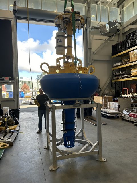
In addition to deployment of the Shallow Water test mooring off Martha’s Vineyard, the CGSN team conducted recovery operations onsite at MAB. They recovered the Coastal Profiler Mooring anchor, deployed in the spring of 2023. The mooring itself had been recovered in August of this year. The team also recovered the Coastal Surface Mooring after ~8 months operating at the proposed Pioneer MAB location. The mooring was deployed in a water depth of 30 m and survived storms with max wave heights of 7.5-10 m and continued to send data to shore!
[media-caption path="https://oceanobservatories.org/wp-content/uploads/2023/11/IMG_6642-1536x1536-1.jpg" link="#"]The Coastal Surface Mooring is safely on deck after ~8 months operating at the proposed Pioneer Mid-Atlantic Bight location. Credit: Sheri N. White © WHOI.[/media-caption]Other activities conducted during the 11-day expedition included a site surveys (utilizing multi-beam, sub-bottom, and ROV) of alternate mooring locations, and cross-shelf and along-shelf CTD surveys to better understand the oceanographic conditions in the Mid-Atlantic Bight.
“Conducting at-sea tests of our infrastructure and detailed environmental surveys of the environment are important to ensure the success of new OOI Array,” said Sheri N. White, Chief Scientist for the recovery cruise. “We were lucky to have excellent weather for our deployment and recovery cruises. But also pleased that our test moorings experienced challenging weather during the deployment. This gives us the confidence that the moorings can operate successfully in the new environment and collect data year-round.” The plan is to deploy the Coastal Pioneer Array in its new location in spring 2024.
More details about and images from the expedition can be found here.
Read MorePBS of North Carolina Blogs about Pioneer’s New Location
In a blog post, the PBS of North Carolina summarizes plans for the relocation of the Coastal Pioneer Array to a site of the coast of Carolina:
[media-caption path="https://oceanobservatories.org/wp-content/uploads/2023/10/PBS-Blog.jpeg" link="#"]Surface moorings of the Pioneer Array loaded with scientific instruments are built to withstand all types of ocean conditions. ©WHOI.[/media-caption]Water covers about 71% of the Earth’s surface, and our oceans hold about 96.5% of it. It’s no surprise then that oceans play a key role in the Earth’s weather, climate and food supply.
So, it’s important to know what’s happening in the ocean. And the ocean off North Carolina’s coast is going to get a closer look starting in 2024. That’s when a set of scientific instruments, called the Coastal Pioneer Array, will be deployed about 35 miles off Nags Head. The system is part of the Ocean Observatories Initiative, or OOI.
“The OOI offers many opportunities for scientists to obtain data to further their research, and it provides insight into conditions in the area for a variety of stakeholders,” said Dr. Albert Plueddemann, project scientist for OOI’s Coastal Global Scale Nodes group at Woods Hole Oceanographic Institution. “We welcome researchers, educators and industry members to reach out to us to explore ways we might work together to maximize the usefulness of the data.”
Read the entire post here.
Read More
Pioneer Mid-Atlantic Bight At-Sea Tests Continue
On Monday October 23, 2023, a team of scientists and engineers from Woods Hole Oceanographic Institution (WHOI) left Woods Hole, MA aboard the R/V Neil Armstrong to conduct a variety of at-sea tests to continue preparations for the anticipated move of the Coastal Pioneer Array to the Mid-Atlantic Bight (MAB), off Cape Hatteras, NC. The science team first traveled to a site off the coast of Martha’s Vineyard to deploy a newly designed shallow water mooring (SWM). This test deployment site was chosen because it offers suitable conditions to test the moorings performance in a shallow water environment, with easy access from Woods Hole, simplifying monitoring and recovery.
The mooring will be deployed for a few months to test the seabed multifunction node, buoyant stretch hose, riser cable, and Prawler profiling vehicle. Engineering data will be collected and assessed prior to the SWM’s deployment at the proposed Pioneer Mid-Atlantic Bight in Spring 2024.
[media-caption path="https://oceanobservatories.org/wp-content/uploads/2023/10/Pioneer-MAB-schematic.png" link="#"]Schematic drawing of the proposed Pioneer MAB moored array to be deployed off the coast of Nags Head, North Carolina. The full array, proposed to be deployed in the spring of 2024, would consist of ten moorings at seven different sites (three sites contain mooring pairs). For the test deployment, one Coastal Surface Mooring was deployed at the Central site and one Coastal Profiler Mooring was deployed at the Northeast site.[/media-caption]From there, the team will head to the Mid-Atlantic Bight to recover a mooring and two anchors that have been in place since spring 2023. Other activities will include a multibeam and sub-bottom site survey and ROV inspection of alternate sites. Water and CTD sampling will be conducted at various depths at the proposed mooring locations. Ancillary science activities will be conducted as time allows. The public comment period on the environmental assessment of the new location is open until October 30, 2023.
“The goal of our test cruises is to evaluate our mooring designs and instrument sampling strategies, and collect environmental data at the new location. This will help to ensure a successful first deployment in the spring of 2004,” said Sheri N. White, Chief Scientist for this expedition and a senior engineer at WHOI. “Understanding the seafloor and water column conditions in the Mid-Atlantic Bight will help us to confirm the optimum locations for the moorings and paths for the gliders and AUVs.”
“This new location in the MAB offers many opportunities for scientists to obtain data to further their research and will provide better insight into conditions in the area for a variety of stakeholders, “said Al Plueddemann, Project Scientist for OOI’s Coastal and Global Scale Nodes group at WHOI, which is responsible for operation of the Pioneer Array. “We welcome researchers, educators, and industry members to reach out to us to explore ways we might work together to maximize the usefulness of the data.”
The new MAB site offers opportunities to collect data on a variety of cross-disciplinary science topics, including cross-shelf exchange and Gulf Stream influences, land-sea interactions associated with large estuarine systems, a highly productive ecosystem with major fisheries, processes driving biogeochemical cycling and transport, and fresh-water outflows during extreme rain events.
The test mooring data will be evaluated during the deployment and after recovery to determine whether any modifications are needed to the mooring designs. The full array will be deployed at the new Mid-Atlantic Bight location in the spring 2024. The At-Sea Test expedition team is expected to return to Woods Hole in early November.
Read More
NSF Issues Notice of Draft Supplemental Site-Specific Environmental Assessment for Pioneer Relocation
The NATIONAL SCIENCE FOUNDATION posted the following announcement today, September 29, 2023:
MEMORANDUM FOR: TRIBES, GOVERNMENT AGENCIES, ORGANIZATIONS, INDIVIDUALS, AND INTERESTED PARTIES
FROM: NATIONAL SCIENCE FOUNDATION (NSF)
RE: Notice of Availability of a Draft Supplemental Site-Specific Environmental Assessment for the NSF Ocean Observatory Initiative (OOI) Pioneer Array Modifications and Relocation to the Mid-Atlantic Bight
The National Science Foundation (NSF) gives notice of the availability of the “Draft Supplemental Site-Specific Environmental Assessment for Pioneer Array Modifications and Relocation to the Mid-Atlantic Bight” (Draft SSSEA) for review and public comment.
NSF proposes to fund the relocation, operation, and maintenance of the NSF Ocean Observatory Initiative’s (OOI) Pioneer Array to the Mid-Atlantic Bight (MAB) off North Carolina in the Northwest Atlantic Ocean (Proposed Action). The OOI is a globally distributed, networked, ocean-focused research observatory with arrays of sophisticated instruments that utilize cutting-edge technologies to observe and study ocean processes. The Pioneer MAB Array would represent a Coastal Scale Node component of the OOI. The Pioneer MAB Array is designed to resolve transport processes and ecosystem dynamics in the vicinity of the shelf-break front, a region of high biological productivity and complex oceanographic dynamics that include intense mesoscale variability and episodic event disturbances (i.e., hurricanes). It would collect high-resolution, multidisciplinary, synoptic measurements spanning the shelf break on horizontal scales from a few kilometers to several hundred kilometers. The array is designed and planned to be relocatable approximately (~) every 5 years with new locations proposed by the NSF with input from the scientific community.
The Proposed Action would (1) relocate the Pioneer New England Shelf (Pioneer NES) Array to the southern MAB (Pioneer MAB Array, Figure 1); 2) modify the mooring designs for the new site water depths; and 3) include additional scientific instrumentation on the moorings. The Proposed Action would occur within the Exclusive Economic Zone (EEZ) of the U.S. but outside of state waters. The Pioneer MAB Array would be a T-shape array located off the coast of Nags Head, North Carolina, starting ~24 kilometers (km) (~13 nautical miles [nm]) offshore, extending ~59 km (~32 nm) east/west and ~49 km (~26 nm) north/south across the continental shelf, centered at the shelf-break front. The Project Area, including the surrounding area of potential effect, would consist of 10 moorings and a 2 km by 2 km (1 nm by 1 nm) square around the center point of each of the mooring locations. In addition, there would be mobile assets, such as autonomous underwater vehicles (AUVs) and gliders that would operate around the moorings. Gliders and AUVs would run underwater missions along tracks in the vicinity of the moored array. Two (2) AUVs and four (4) gliders would be used to provide underwater monitoring abilities along and across the shelf and within the waters of the continental slope. Gliders would be deployed on a 60-90-day rotation schedule and would be operated continuously along pre-determined paths, while the AUVs would be deployed for limited periods of ~4 days every 2 months.
[media-caption path="https://oceanobservatories.org/wp-content/uploads/2023/09/SSSEA-Figure-1-revised38-scaled.jpg" link="#"]Figure 1. Proposed Pioneer MAB Array of Moorings and Surface Projection of Underwater Track lines for Mobile Assets[/media-caption]The Pioneer MAB Array is proposed to be deployed in April 2024. The array and associated AUVs and gliders would be serviced primarily by vessels from the U.S. Academic Research Fleet (ARF) with support from local chartered vessels when needed; a proposed schedule for installation, operations, and maintenance is included in the Draft SSSEA. Installation, operations, and maintenance activities would use standard methods and procedures currently used by the ocean observing community. Like on the Pioneer NES Array, the moorings deployed at Pioneer MAB would include anchors and benthic nodes designed to be fully recoverable, minimizing impact on the seabed.
The Draft SSSEA evaluated the potential impacts of the Proposed Action on the human and natural environment, pursuant to the National Environmental Policy Act (NEPA) and tiers to existing OOI NEPA documentation1. The Draft SSSEA focused on activities and associated potential impacts on marine resources (e.g., geological, marine biological, socioeconomic, etc.) that were not previously assessed by existing OOI NEPA analyses. The conclusions from the Draft SSSEA were used to inform the NSF Division of Ocean Sciences (OCE) of potential environmental impacts of the Proposed Action.
1OOI NEPA documents are available on the NSF website.
Impacts from the placement of proposed mooring anchors or nodes on the seafloor would include temporary disturbance of soft sediments and coverage of relatively small areas of substrate by the anchors and scientific sensors (~37 m2) for the deployment period. Over time, the natural movement of sediments by ocean currents and burrowing organisms would reestablish natural bottom topography. Upon conclusion of operations, the entire system, including anchors and nodes, would be removed from the MAB Project Area. A small amount of Essential Fish Habitat (EFH) may potentially be impacted during installation activities. The short-term and minor increases in turbidity and sedimentation resulting from system installation, operations, maintenance, and removal would not affect the ability of EFH to support healthy fish populations, and affected areas are expected to recover quickly. The vessels and activity associated with installation and maintenance of the moorings may cause marine species, such as Endangered Species Act (ESA)-listed marine mammals, to avoid the immediate vicinity of the proposed Pioneer MAB Array sites, but this impact would be brief and temporary due to the nature of the proposed activities (estimated time to deploy a mooring with one vessel is 12 to 24 hours). Entanglement and vessel strike/collision threats to marine mammals or sea turtles are not anticipated due to the equipment design, slow operational speed (0.5 to 2 knots), and use of NMFS standard oceanographic marine mammal vessel strike avoidance measures, including special measures for North Atlantic Right Whale. The use of gliders and AUVs is not expected to affect marine species, as the proposed gliders and AUVs are self-contained and move slowly within the water column similar to a dolphin or whale. Additional new scientific instrumentation sensors would be mounted on or incorporated into the existing mooring designs; however no adverse effects to marine species are anticipated from the new sensors. Mooring sites were selected to avoid historic and cultural resources (e.g., shipwrecks).
Specific sensitive areas were considered during early planning and siting of the Pioneer MAB Array. The array would not overlap with or be anticipated to impact artificial reefs or fishery nursery areas. Four of the Pioneer MAB Array moorings would be located within the loggerhead sea turtle Constricted Migratory Corridor; however, they are not anticipated to impede sea turtle migration. The Pioneer MAB Array would not overlap with loggerhead sea turtle Coastal Critical Habitat Designation (sargassum habitat). The Pioneer MAB Array’s southernmost mooring would be located within a joint Snapper-grouper/Coral Reefs and Hardbottom/Dolphin and Wahoo Habit Areas of Particular Concern (HAPC) designated by the South Atlantic Fisheries Management Council (SAFMC). The small scale and temporary nature of the single mooring would have little to no impact on the HAPC. A survey conducted of the sites also did not indicate the existence of corals.
Due to the distance from shore, small footprint, localized and temporary nature (~5 years), interactions between the Proposed Action and other ocean users, including fishing operations, in the study area are expected to be limited. Other activities, including fisheries, could occur within the proposed project area; a safe distance, however, would need to be kept from Pioneer MAB Array individual moorings. Any potential space-use conflicts would be minimized through outreach and communication with ocean users. The USCG would be contacted prior to the deployment of moorings as part of the Private Aids To Navigation (PATON) approval process and the Pioneer MAB Array moorings would be easily visible and avoidable. All mooring locations and associated components of the Pioneer Array would be published in NOAA charts, Notice to Mariners and Local Notice to Mariners. Gliders and AUVs would be marked with the name of the owning organization and a contact telephone number that ocean users could call to report any encounters at sea.
The Draft SSSEA also assessed potential cumulative effects of the Proposed Action. Overall, the combination of the proposed activities with other activities occurring in the region is expected to produce only a negligible increase in overall disturbance effects on the marine environment. Given the distance from shore, small footprint, temporary nature, and experience with Pioneer NES, significant impacts from the Proposed Action are not anticipated on the marine environment. While the Proposed Action may affect EFH and ESA-listed species, adverse effects are not likely. NSF will consult with federal regulatory agencies as applicable and appropriate.
Additional information about the proposed Pioneer MAB Array can be found in the Draft SSSEA and tiered OOI NEPA documentation, including details on relocation, operations, and maintenance; scientific instrumentation; potential effects, and diagrams of the array components.
After reviewing and considering all public comments received during the public comment period and regulatory processes, NSF will issue a Final Supplemental Site-Specific Environmental Assessment (Final SSSEA), accompanied by a decision document.
Public Comments:
The Draft SSSEA regarding the proposed action is posted for public comment on the NSF website closing on October 28, 2023. We welcome any comments you may have on the Draft SSSEA. Comments may be submitted via email to: nsfnepaooipioneer@nsf.gov. Comments received will be addressed in the Final SSSEA.
Read More