
Posts Tagged ‘Coastal Pioneer Array’
New Controller Latest in OOI Innovations
Having equipment in the water around the clock for six months at a time provides many challenges for the land-based OOI engineering team charged with keeping the equipment operational so there is a continual flow of data to shore. Maintaining consistent, reliable power for the ocean observing equipment is at the top of this list of challenges.
OOI’s data-collecting instruments attached to the moorings run on batteries charged by renewable wind and solar energy. OOI is in the process of replacing the current solar panels with new panels that are more efficient at generating energy, even when shaded. To supplement this upgrade, the OOI arrays are also being outfitted with a brand-new solar controller to manage the energy going into the batteries. Like with the new solar panels, OOI engineers looked for a controller that was available commercially for easier repair and replacement.
“What was important to us was finding a way to use these new solar panels in the best, most optimal way,” said Woods Hole Oceanographic Institution (WHOI) engineer Marshall Swartz. “We looked for a company that would help us specify and build a customized algorithm for a controller that would optimize the functionality of the panels by taking into account battery temperatures.”
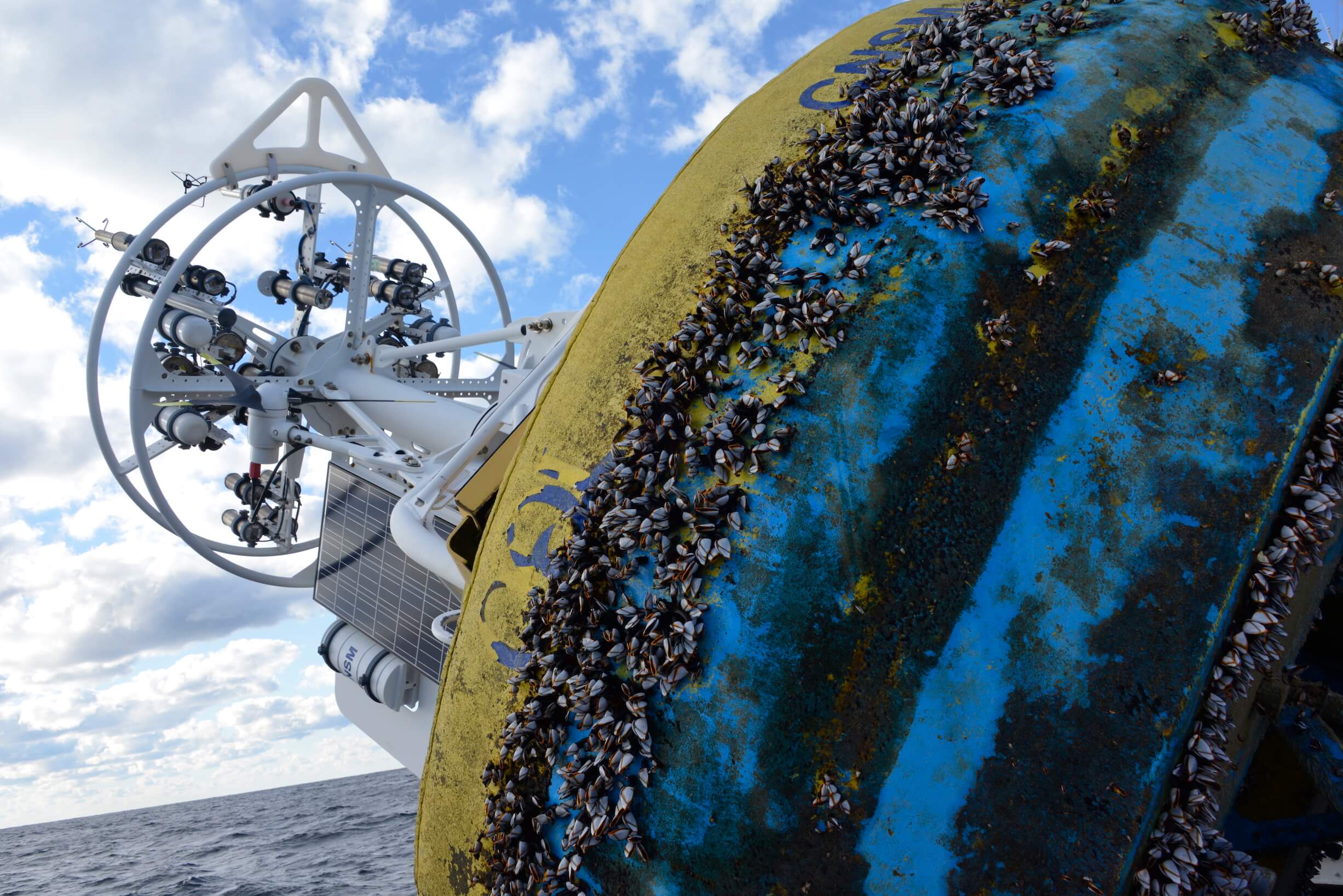
[media-caption path="/wp-content/uploads/2021/12/DSC0486-2.jpeg" link="#"]Buoys get quite the workout when they are in the water for six months and more. Powered by wind, solar, and batteries, OOI has recently improved the way energy from the solar panels is managed with new controllers. Credit: ©WHOI, Darlene Trew Crist. [/media-caption]
Some larger, older controllers can consume up to 3-5% of the energy coming into the device, but the new controller is smaller and more efficient, helping to optimize the amount of energy harvested.
Temperature conditions play a big role in how effectively the energy is managed. Changing battery temperatures require the controller to adjust its charge settings to maintain battery life and capacity. The controllers used on OOI moorings sense battery temperature and automatically adjust to assure best conditions to assure reliable operation.
“It’s really essential for us to maintain the proper charge levels for existing temperature conditions,” said Swartz. The OOI buoys encounter a wide range of temperatures: from subfreezing temperatures up to 40°C (over 100°F) when a buoy is sitting in the parking lot before it is deployed. When the buoys are deployed, water temperatures can vary widely from -1 to 33°C (~30 to 91°F), depending on seasonal conditions.
The new controller automatically regulates the amount of electricity going into the battery under such varying temperature conditions. If the wind turbines are generating more energy than the battery needs, for example, the controllers direct excess power into an external load that dissipates heat and adds resistance to the spinning of the wind turbines, preventing the turbines from spinning too fast, possibly damaging their bearings.
“As parts of the OOI infrastructure need replacing or to be upgraded, this offers us the opportunity to find more efficient, and often times, off-the-shelf, less-expensive replacements that will help us keep the arrays functioning and data flowing,” Swartz said. “It’s a winning combination for all parts of the operation.”
Read More
R/V Neil Armstrong in Drydock while OOI Team Onboard
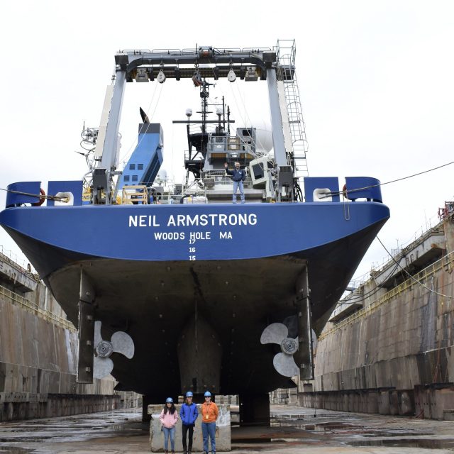
The fact that the R/V Neil Armstrong was out of the water on blocks at the Deytens Shipyard in North Charleston, SC, didn’t deter the Ocean Observatories Initiative (OOI) Coastal and Global Scale Node (CGSN) Team members from loading equipment and setting up laboratories for the first at-sea test deployment for the Coastal Pioneer Array in its new location in the Southern Mid-Atlantic Bight. Woods Hole Oceanographic Institution (WHOI) Port Engineer Hank Ayers helped make this dual operation possible. Ayers has been handling logistics for the Armstrong for 10 years. Over the course of time, he’s developed a knack for multi-tasking, and keeping on schedule and budget, while keeping the 238-foot Armstrong in tip top shape.
Looking at the Armstrong’s at-sea schedule, Ayers arranged for a regulatory drydock period prior to the Pioneer test deployment expedition near the array’s test deployment off the coast of Nags Head, NC. (See figure to right). Regulatory drydock checks are required about every two and a half years for inspections mandated by the US Coast Guard and the American Bureau of Shipping. While in drydock, the Armstrong underwent inspections of the propeller shaft, 17 sea chest valves were checked for condition and wear, the port and starboard anchor chains were replaced, and about 10 percent of the ship’s hull was repainted most of this along the waterline, where it is most susceptible to wear and marine growth, while other sections were touched-up as needed. Other regular maintenance tasks were also completed while the crew was in port.
[embed]https://vimeo.com/819612282[/embed]Ayers explained the complexity of getting a huge vessel that weighs 2641 tons with a 50-foot beam into drydock so the keel can be inspected. “The ship is steered into a big basin with a movable wall at one end. The goal is to have the ship land on top of blocks so when the water is pumped out, it will be securely in place. It’s a delicate process. There’s a ball that floats up at the bow when the ship is in the right position. Once aligned, the crew keeps the ship centered and in position. A diver is also in the basin to make sure that once the ship gets close to the blocks there are no problems down there. Once the ship is in place on the blocks, the water is drained out.”
The Armstrong was out of the water for 20 days. The Pioneer At-Sea Test team arrived on February 16 to begin the unusual process of mobilizing for the expedition while the ship was technically on land. The shipyard is equipped with huge cranes needed to load the 8000+ pound moorings onto the stern of the ship. Under normal operating conditions, the cranes on the ship would be used to load the equipment onboard.
Said CGSN Instrument Lead Jennifer Batryn who helped with the mobilization, ““It was definitely weird seeing the Armstrong out of the water. It’s a very different perspective than most people are used to seeing for the ship and was especially interesting to observe given OOI uses the Armstrong for a number of our cruises. Other than that, once we were on the ship while it was still in drydock, it really didn’t feel that much different. The ship was very stable and we went through the normal operations of getting the equipment onboard and ready for departure.“
Once loaded, some of the CGSN team headed home to Woods Hole Oceanographic Institution, while a team of nine WHOI engineers and scientists stayed onboard to execute the test deployments.
[media-caption path="https://oceanobservatories.org/wp-content/uploads/2023/04/DSC_0258-2-scaled.jpg" link="#"]Not a view many get to see! Armstrong’s Chief Engineer Pete Marczak waving from the stern and CGSN Team members Irene Duran, Jennifer Batryn, and Dee Emrich standing in the North Charleston, SC drydock give a good sense of the size of the RV Neil Armstrong below the waterline. Credit: Rebecca Travis © WHOI.[/media-caption]The process of refloating the ship commenced on February 21 with the filling of the drydock. It took about 6 hours and 134 million gallons of water to raise the Armstrong in the dock to sea level and ready for departure. The movable wall was taken out and the Armstrong maneuvered over to a nearby pier to continue to get ready for sea and OOI work.
Added Ayers, “The Armstrong is a beautiful, capable ship. When she’s out of the water, you get a sense of her size and capabilities. It’s always a wonderful sight.” And one that won’t happen for a while. Armstrong’s next scheduled drydock is in 2025, so for now, the ship is in good working order and ready to continue its job as a scientific workhorse.
[embed]https://vimeo.com/819618715[/embed]
Videos credit: Rebecca Travis © WHOI.
Read MoreWatch Pioneer Relocation Update

Dr. Albert Plueddemann, senior scientist with Woods Hole Oceanographic Institution and principal investigator for the Coastal and Global Scale Nodes of the Ocean Observatories Initiative (OOI), was the featured speaker at the April 2023 “Science on the Sound” Lecture Series at the Coastal Studies Institute on the ECU Outer Banks Campus. Dr. Plueddemann presented information on an exciting new research ocean observing array headed to the offshore waters of the Outer Banks. Relocation of the Ocean Observatories Initiative Pioneer Array happened on April 20. For those who couldn’t attend in person, the presentation can be watched here.
The OOI Pioneer Array was envisioned as a re-locatable coastal array to investigate physical and biochemical exchange processes on the continental shelf and upper slope.The array infrastructure includes moorings, gliders, and AUVs. The Array was previously sited on the New England Shelf (NES), centered at the shelfbreak south of Martha’s Vineyard, MA.
The new MAB site represents a different environment than the New England Shelf location and offers opportunities to collect data on a variety of cross-disciplinary science topics, including cross-shelf exchange and Gulf Stream influences, land-sea interactions associated with large estuarine systems, a highly productive ecosystem with major fisheries, processes driving biogeochemical cycling and transport, and fresh-water outflows during extreme rain events.
Watch the presentation here.
A Data Assimilative Reanalysis at the New England Shelf Pioneer Array
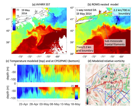
Scientists undertook a four-year retrospective reanalysis of ocean circulation at the Pioneer Coastal Array site. The system captures circulation features that characterize the inhomogeneous, rapidly evolving, and ephemeral submesoscale circulation.
Read MoreShelfbreak Productivity Interdisciplinary Research
The continental shelfbreak of the Mid-Atlantic Bight supports a productive and diverse ecosystem, driven by primary production by phytoplankton. The Coastal Pioneer Array provided unprecedented spatial and temporal resolution of the frontal system, including a four-dimensional context to conduct a detailed study of frontal dynamics and plankton communities.
Read MoreShelf Water Subduction and Cross-Shelf Exchange
In recent years, the Gulf Stream in the Northwest Atlantic has become increasingly unstable and is shedding more warm core rings in the Slope Sea.The Coastal Pioneer Array at the Mid-Atlantic Bight shelf edge identified a form of offshore transport of water for the first time, supporting an ocean model to study the dynamics of the shelf-water offshore transport.
Read MoreTest Deployments Underway for Pioneer Relocation
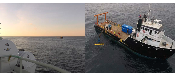
Tuesday February 21, 2023, a team of scientists and engineers from Woods Hole Oceanographic Institution (WHOI) left Charleston, SC aboard the R/V Neil Armstrong to begin test deployments in preparation for the installation of an Ocean Observatories Initiative (OOI) ocean observing system in its new location in the southern Mid-Atlantic Bight (MAB). The science team will deploy two test moorings off the coast of North Carolina, occupying shallow and deep sites of the proposed array. The deployments will supplement computer modeling to ensure the mooring designs perform as expected in the MAB environment. Once the array is fully operational in 2024, the ocean data collected will be available online in near real-time to anyone with an Internet connection.
Ocean observing data helps to track, predict, manage, and adapt to changes in the marine environment. Coastal communities use ocean observing data to prepare for floods and other natural disasters. The instrumented arrays gather physical, chemical, geological, and biological data from the air-sea interface to the seafloor, providing a wealth of information for research and education.
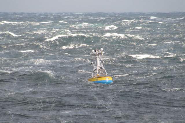
[media-caption path="https://oceanobservatories.org/wp-content/uploads/2023/02/CNSM_buoy_atsea-2-1.png" link="#"]Offshore conditions can be brutal for moorings that remain in the water for six-month deployments. The new location for the OOI’s Coastal Pioneer Array is designed to withstand treacherous conditions, including extreme storms. Credit: ©Woods Hole Oceanographic Institution.[/media-caption]“This new Pioneer Array location in the MAB offers many opportunities for scientists to obtain data to further their research, and will provide better insight into conditions in the area for a variety of stakeholders,“ said Al Plueddemann, Project Scientist for OOI’s Coastal and Global Scale Nodes group at WHOI, which is responsible for operation of the Pioneer Array. “We welcome researchers, educators, and industry members to reach out to us to explore ways we might work together to maximize the usefulness of the data.”
The OOI is funded by the National Science Foundation (NSF) to collect and deliver ocean data in select locations for 25 years or more. This longevity of data collection makes it possible for researchers to identify both short term processes and long-term trends in our changing ocean. The OOI’s Coastal Pioneer Array was designed to be relocatable, and its first deployment was off the coast of New England at the Continental Shelf/Slope interface, where it collected data from 2016 until it was recovered in September 2022. The new location off the coast of North Carolina was chosen by NSF based on input from the science community during a series of NSF-sponsored workshops in 2022.
Dr. Reide Corbett, Executive Director of the Eastern Carolina University’s Coastal Studies Institute (CSI), is enthusiastic about the opportunities the Pioneer Array will bring to the region. “The cross-shelf suite of instrumentation off northeastern North Carolina’s coast is in a region of complex physics and critical ecosystem dynamics that draws interest from many disciplines and creates opportunities for transformational science. This is also in a region with a growing renewable energy sector, including two active offshore wind leases, with opportunities to partner with the agencies involved. The Coastal Studies Institute is excited about the observations that will be made from these instruments, allowing us to better address climate change influences in the coastal ocean, and improve ocean/weather/storm forecasts through data sharing. Beyond just the instruments in the water, the new partnerships and collaborations created as part of this deployment will provide the ability to better engage this socio-economically diverse region, with disadvantaged groups more impacted by sea level rise and climate change compared to many coastal regions. This broad network of partnerships across the region will provide a mechanism to drive knowledge to action,” states Corbett.
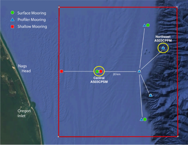
[media-caption path="https://oceanobservatories.org/wp-content/uploads/2023/02/Pioneer-MAB-schematic.png" link="#"]Schematic drawing of the Pioneer MAB moored array to be deployed off the coast of Nags Head, North Carolina. The full array, to be deployed in the spring of 2024, will consist of ten moorings at seven different sites (three sites contain mooring pairs). For the test deployment, one Coastal Surface Mooring will be deployed at the Central site and one Coastal Profiler Mooring will be deployed at the Northeast site.[/media-caption]The new MAB site represents a different environment than the New England Shelf location and offers opportunities to collect data on a variety of cross-disciplinary science topics, including cross-shelf exchange and Gulf Stream influences, land-sea interactions associated with large estuarine systems, a highly productive ecosystem with major fisheries, processes driving biogeochemical cycling and transport, and fresh-water outflows during extreme rain events.
The MAB location is expected to have different wind, wave, and current conditions than the Pioneer Array experienced on the New England Shelf. In addition, deployments in the new location will be in both shallower and deeper water depths than those off the New England coast.
A Coastal Surface Mooring (CSM) will be deployed at 30 meters depth at 35o 57.00’ N, 75o 07.5’ W. The CSM is specifically designed to examine coastal-scale phenomena and withstand the challenging conditions of shallow coastal environments. The Surface Mooring contains instruments attached to a Surface Buoy floating on the sea surface, a Near Surface Instrument Frame 7 meters below the surface, and a Seafloor Multi-Function Node (MFN) located on the seafloor. Additionally, the Surface Buoy contains wind turbines and solar panels for power generation and antennas to transmit data to shore via satellite.
A Coastal Profiler Mooring (CPM) will be deployed at 600 meters depth, 36o 03.80’ N, 74o 44.56’ W. The CPM contains a Wire-Following Profiler that houses instruments. The Wire-Following Profiler moves through the water column along the mooring riser, continuously sampling ocean characteristics from about 23 m below the surface to 23 m above the sea floor. The CPMs also carry an upward-looking Acoustic Doppler Current Profiler to measure ocean currents over the same region of the water column traversed by the profiler.
The test mooring data will be evaluated during the deployment and after recovery to determine whether any modifications are needed to the mooring designs. The plan is to deploy the full array in the spring 2024.
An update on the Pioneer Array relocation is planned for April 20 at 6 pm at the Coastal Studies Institute on East Carolina University’s Outer Banks Campus. Contributing to the CSI “Science on the Sound” lecture series, WHOI’s Dr. Plueddemann will discuss the Pioneer Array infrastructure, instrumentation, and what is planned for its upcoming move off the North Carolina coast. The event is free and open to the public. For those unable to attend, the program will be live-streamed, as well as archived for later viewing, on the CSI YouTube Channel.
[media-caption path="https://oceanobservatories.org/wp-content/uploads/2023/02/A-Frame.png" link="#"]An A-frame at the stern of the ship is used to lift an OOI Coastal Surface Mooring into the water at the start of the deployment. A team secures guidelines to ensure its movements are controlled. Credit: Darlene Trew Crist © WHOI.[/media-caption] [media-caption path="https://oceanobservatories.org/wp-content/uploads/2023/02/DSC0418-scaled.jpg" link="#"]Surface Mooring Recovery operations. Credit: Deidre Emrich © WHOI.[/media-caption]
Read More
Coastal Review Reports on Pioneer’s Relocation
The Coastal Pioneer Array will have a new home in the Southern Mid-Atlantic Bight in the spring of 2024. Just like any move, there are lots of preparations necessary. In this case, test deployments are now taking place to ensure the Array can be in tune with its new environment.
Reporter Jennifer Allen provides insight into the ongoing preparations for the move and plans forward in an article in Coastal Review.
Read More
Mission Accomplished: Nine Years of Ocean Data in Support of Solid Science
In November 2022 the Woods Hole Oceanographic Institution’s (WHOI) R/V Neil Armstrong made its final voyage off Cape Cod to the location of the Pioneer Array, marking the end of nearly a decade of data collection as part of the National Science Foundation’s (NSF) Ocean Observatories Initiative (OOI). The mission of this cruise, Pioneer 19, was to perform the final recovery of all ten instrumented moorings and four gliders that had been collecting multidisciplinary ocean and atmospheric measurements since Pioneer 1 was first deployed in 2013. Over the course of nine years, the array, weighing in at nearly 60 tons, was recovered and redeployed twice per year for a total of 18 times, while it collected and transmitted measurements from hundreds of instruments back to shore and over the internet without interruption.
[media-caption path="/wp-content/uploads/2022/11/DSC_0901.jpg" link="#"]The Pioneer 19 Science Party marks the occasion of the first deployment of the Central Surface Mooring that launched the Coastal Pioneer Array on November 21, 2013. The team had their photo taken aboard the R/V Neil Armstrong at the exact time (1:16 pm) when the very first mooring was in place. Credit: Rebecca Travis © WHOI.[/media-caption]
The Pioneer Array was conceived as part of the OOI, which represents a paradigm shift in oceanography. Unlike traditional oceangoing research cruises that may last for a few weeks and are often focused on a particular topic by a specific research group, multidisciplinary data from the OOI arrays are provided in near real-time 24 hours a day, 365 days per year to anyone with an internet connection, for an expected duration of 30 years. The OOI originally consisted of seven arrays in the North and South Atlantic, strategically deployed in water depths ranging from 25 to several thousand meters, to collect measurements related to ocean processes that impact life on the planet. Scientists, educators, and laypersons have taken full advantage of these data since the first of OOI’s array went into the water.
Charting a Trail-Blazing Path
To meet the need for reliable operations of uncrewed cabled and uncabled observatory platforms deployed to the world’s oceans for 30 years, the OOI adopted and tailored formal systems engineering processes established for mission critical systems by government organizations such as NASA and the Department of Defense. These processes included the establishment of science objectives for the OOI that were used to develop engineering requirements. The engineering requirements were decomposed to atomic, testable, “level four” requirements used to create preliminary and detailed software, mechanical, and electrical designs for the OOI infrastructure. While OOI leveraged technology from existing state-of-the-art ocean observing systems, some of the new requirements adopted by OOI included year-long deployments of moorings and gliders in some of the harshest locations in the global oceans. Some of the challenges included instrumenting active seafloor volcanic regions via cables that extend for hundreds of miles across the seabed, telemetering measurements from more than 900 instruments on the seabed, buoys, and free-swimming vehicles to shore via satellite for posting to the internet in near real-time, and piloting a glider fleet that is second in size to the US Navy around the clock.
Pioneer 1 departed on 20 November 2013 from the WHOI dock aboard the RV Knorr, a storied academic research vessel responsible for supporting some of the most significant ocean discoveries of the past century. The mission of Pioneer 1 was to deploy one surface mooring and two profiler moorings during seven days of operation on site. With a 14-person science party aboard, the Knorr steamed to the predetermined site for the “Central Surface Mooring” of the Pioneer Array and completed the deployment of the first mooring by 1:16 PM on 21 November 2013. Later Pioneer cruises would fully populate the array by increasing the number of deployed moorings to include three Surface Moorings, each weighing nine tons, and five Profiler Moorings, at six tons each, plus up to six free-swimming gliders.
Since 2013, the Pioneer Array has steadfastly done its job, collecting, and telemetering measurements to shore, which have been used in tens of science studies leading to new understandings about coastal processes and the health of the planet. The journey does not end with the completion of Pioneer 19. The Pioneer Array will be refurbished and adapted to meet new requirements associated with its next deployment site off North Carolina, with its first deployment scheduled for spring 2024. The wealth of data collected off the New England Shelf will remain available online and continue to be used to answer scientific questions about this region for years to come.
Written by Paul K. Matthias, Senior Program Manager for the OOI.
Read More
Students’ Mini-Boat and Drifter Launched from R/V Neil Armstrong
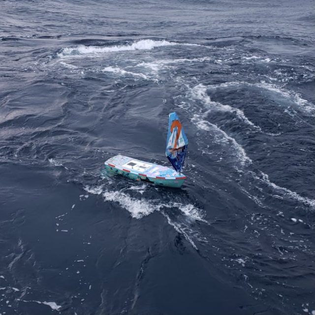
On Sunday November 13, 2022, the Pioneer 19 Team and crew of the R/V Neil Armstrong switched gears from their Pioneer recovery operations to launch a mini-boat and a drifter. Both were constructed by high school students from Waterford, CT, with the help of fourth grade Waterford students, who decorated its sails and hull. The boat is part of the Educational Passages program run by Cassie Stymiest in which the Connecticut high school students participate. The drifter is part of the Student Drifters program developed by the National Oceanic Atmospheric Association (NOAA) and now administered by the Gulf of Maine Lobster Foundation.
The boat, named Lady Lance, contains art inside and messages focused on climate hope and ocean optimism. The students will track the boat’s progress across the Atlantic, as well as the drifter, with the help of James Manning, a retired NOAA employee. Students in Michael O’Connor’s Early College Experience Marine Science Class at Waterford High School built the boat and will follow its progress for the remainder of the school year. The students will follow the progress of both, using GPS telemetry.
[media-caption path="/wp-content/uploads/2022/11/WhatsApp-Image-2022-11-14-at-9.53.24-AM.jpeg" link="#"]The mini-boat was successfully launched from the deck of the R/V Neil Armstrong on Sunday November 13. The boat hopes to make its way across the Atlantic as did its predecessor. Credit: John Lund ©WHOI.[/media-caption]
“We are delighted to be able to support the work of the Waterford students,“ said John Lund, Chief Scientist of the Pioneer Array recovery team aboard the R/V Neil Armstrong. “Their interest, curiosity, and enthusiasm for this project is contagious, and we all will be tracking Lady Lance as she moves through the Atlantic. We also hope that some students are so inspired by this work that they go on to be scientists.”
Lady Lance is the second of such trans-Atlantic launches. The first occurred in 2016 when Lady Lance’s sister ship, Lancer, was launched from the R/V Neil Armstrong. (A good explanation of the winds and currents Lady Lance may encounter is provided at 8:30). The boat’s journey will be influenced by the wind, while the drifter’s journey will be dictated by the currents, allowing for comparisons of conditions in the ocean region.
Lancer ultimately landed in Galway, Ireland, where it was found by a young girl who was also a Sea Scout. People in Connecticut and Galway raised money to have it refurbished and it was re-launched by The Irish Marine Institute. From Ireland, the boat made its way to the United Kingdom where it landed in Plymouth, England. The boat was refurbished by the Ocean Conservation Trust at the National Aquarium in Plymouth and served as a focus for their STEMFEST, which hosted more than 50 school groups from around the UK. STEMFEST students created projects that will be sent in an upcoming Lancer launch at the end of November. An affiliated project, Project Ocean Climate Nexus (Project OCN), is hosting a conference at the National Aquarium in March. Participants will see student research based on the data produced by the mini boats and drifters, students from the US and UK presenting projects.
The Spanish Institute of Oceanography will launch Lancer at the end of November, nearly in sync with Lady Lancer’s launch from the opposite side of the Atlantic.
[media-caption path="/wp-content/uploads/2022/11/WhatsApp-Image-2022-11-14-at-9.53.27-AM-2.jpeg" link="#"]A drifter was also successfully launched to spread messages of hope about the ocean across the Atlantic. Credit: John Lund ©WHOI.[/media-caption]
“While the students have put hard work into the development of these instruments, the real hard work begins upon launch. They will be following the boat and drifter, analyzing data from the boats and adding those data points to other data available from sources like the Pioneer Array and other data sets that are publicly available, to ask questions about the physical and chemical functions of the ocean and atmosphere,” said Michael O’Connor, Waterford High School Marine Science teacher. “The project serves as a launching point to do some independent analysis and to connect with and contribute to the world through science, art, and technology.”
The students have provided digital ways for everyone to follow along with these trans-Atlantic crossings:
- Both Lancer and Lady Lance are trackable from https://educationalpassages.org/events/atsea/
- Lady Lance and her drifter can be tracked here: https://studentdrifters.org/tracks/drift_whs_2022_1.html
- Lady Lance’s drifter data can be accessed here: https://studentdrifters.org/tracks/drift_whs_2022_1.dat or .csv
Read More