
Posts Tagged ‘Coastal Pioneer Array’
Pioneer Data Show the Continental Shelf Acts as a Carbon Sink
Excerpted from the OOI Quarterly Report, 2022.
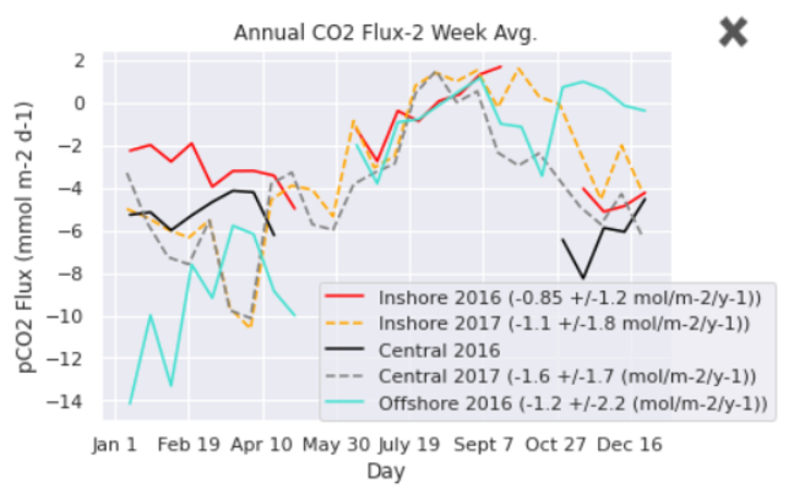
[media-caption path="https://oceanobservatories.org/wp-content/uploads/2021/02/Pioneer-for-Science-Highlights.png" link="#"]Figure 23. Weekly average air-sea CO2 flux estimated for the Pioneer Array Inshore, Central and Offshore moorings during 2016 and 2017. A negative flux is from the atmosphere to the ocean. From Thorson and Eveleth (2020).[/media-caption]In the summer of 2020 the Rutgers University Ocean Data Labs project worked with the Rutgers Research Internships in Ocean Science to support ten undergraduate students in a virtual Research Experiences for Undergraduates program. Two weeks of research methods training and Python coding instruction was followed by six weeks of independent study with a research mentor.
Dr. Rachel Eveleth (Oberlin College) was one of those mentors. Already using some of the Data Labs materials in her undergraduate oceanography course, she saw an opportunity to leverage the extensive OOI data holdings to engage students in cutting edge research on a limited budget during a time when her own field work was curtailed due to the COVID-19 pandemic. Dr. Eveleth advised Alison Thorson from Sarah Lawrence College (NY) and Brianna Velasco form Humboldt State University (CA) on the study of air-sea fluxes of CO2 on the US east and west coast, respectively.
Preliminary results were presented at the 2020 Fall AGU meeting. A poster authored by Thorson and Eveleth (ED037-0035) evaluated pCO2 data from the three Pioneer Array Surface Moorings during 2016 and 2017. They showed that the annual mean CO2 flux across all three sites for the two years was negative, meaning that the continental shelf acts as a sink of atmospheric carbon. The annual average flux was -0.85 to -1.6 mol C/(m2 yr), but the flux varied significantly between mooring sites and between years (Figure 23). Investigation of short-term variability in pCO2 concentration concurrent with satellite imagery of SST and Chlorophyll was consistent with temperature-driven, but biologically damped, changes.
[media-caption path="https://oceanobservatories.org/wp-content/uploads/2021/02/Pioneer-for-Science-Highlights.png" link="#"]Figure 24. Hourly (dots) and monthly (lines) average air and water CO2 concentration observed at the Endurance Array Washington Offshore mooring during 2016 and 2017. From Velasco et al. (2020).[/media-caption]A poster by Velasco, Eveleth and Thorson (ED004-0045) analyzed pCO2 data from the Endurance Array offshore mooring. Three years of nearly continuous data were available during 2016-2018. The seasonal cycle showed that the pCO2 concentration in water was relatively stable and near equilibrium with the air in winter, decreasing in late spring and summer (Figure 24). Short-term minima in summer were as low as 150 uatm. Like the east coast, the mean air-sea CO2 flux was consistently negative, meaning the coastal ocean acts as a carbon sink. The annual means at the Washington Offshore mooring for 2016, 2017 were -1.9 and -2.1 mol C/(m2 yr), respectively. The seasonal cycle appears to be strongly driven by non-thermal factors (on short time scales), presumably upwelling events and algal blooms.
These studies, although preliminary, are among the first to use multi-year records of in-situ CO2 flux from the OOI coastal arrays, and to our knowledge the first to compare such records between the east and west coast. Dr. Eveleth’s team intends to use the rich, complementary data set available from the OOI coastal arrays to investigate the mechanisms controlling variability and role of biological vs physical drivers.
Read More
Pioneer Data Complements Fisher-Collected Data to Explain Ocean Processes and Fish Distributions
Since 2014, fishers in southern Rhode Island and scientists from Woods Hole Oceanographic Institution (WHOI) have been working collaboratively to share data and learn from one another. For the past seven years, fishers have been collecting oceanographic data through the Commercial Fisheries Research Foundation’s (CFRF) Shelf Research Fleet and WHOI has shared data collected by the Pioneer Array.
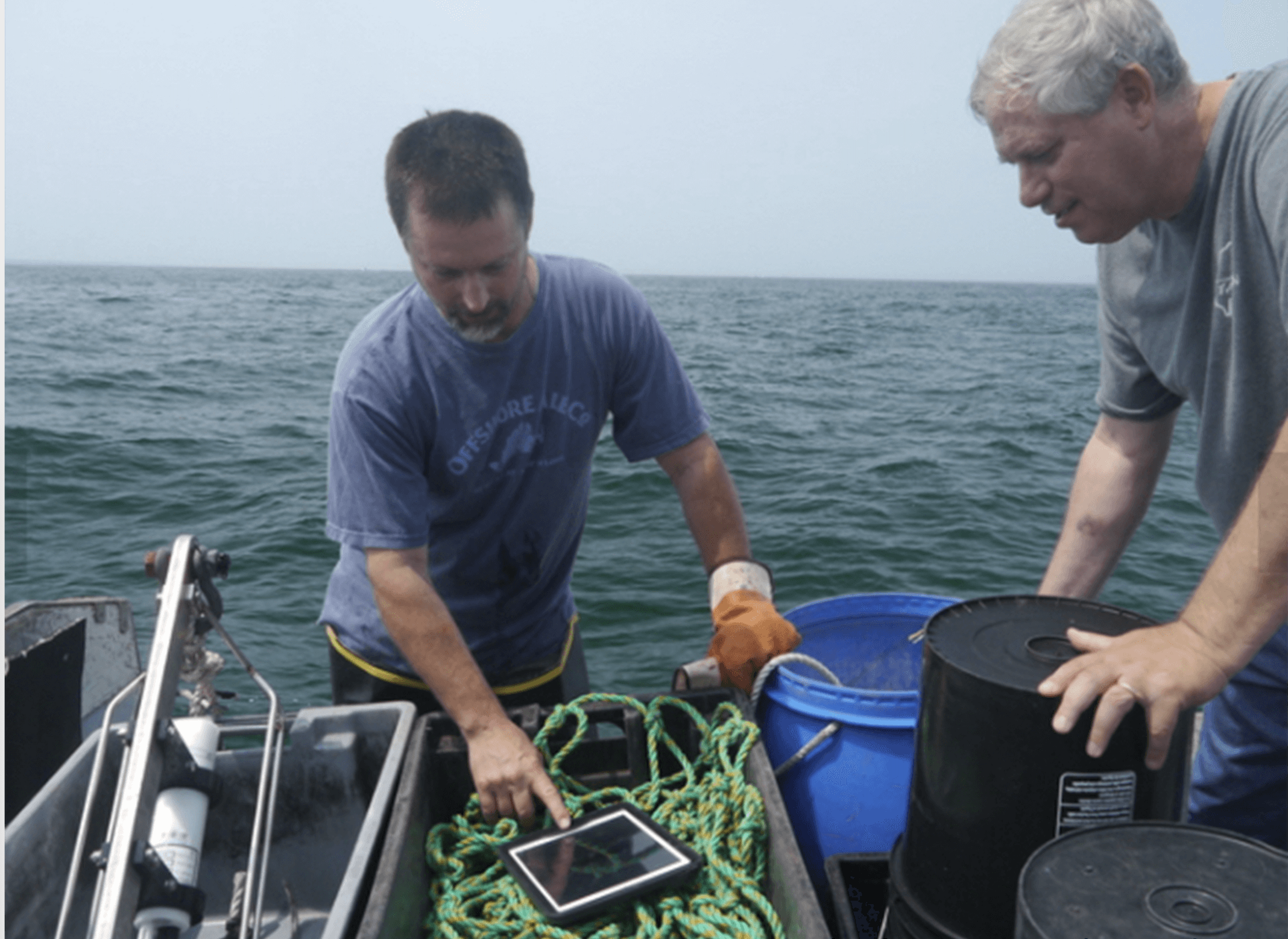
Through this partnership, fishers have come to value data from the Shelf Research Fleet and the Pioneer Array, as well as the insights of researchers who have spent years studying some of the most productive fisheries in U.S. waters. WHOI provides Pioneer data to fishers, and fishers provide oceanographic data collected during their normal fishing operations using CTDs which measure conductivity, temperature and depth information through the CFRF/WHOI Shelf Research Fleet. When the CTDs are brought onboard they wirelessly communicate the temperature data to an iPad where fishermen can view oceanographic conditions and ultimately upload the data to scientists. These CTD measurements provide the physical properties of sea water, which help determine the location and composition of the catch.
[caption id="attachment_20251" align="alignright" width="300"] Fisher Michael Marchetti (left) and WHOI scientist Glen Gawarkiewicz discuss data collected by a portable CTD. Credit: Commercial Fisheries Research Foundation.[/caption]
“This arrangement is a good example of how if people are willing to listen and really learn to value issues that are going on for another group, remarkable things can occur,” said Glen Gawarkiewicz, a WHOI researcher who leads the CFRF -WHOI Shelf Research Fleet.
In December, Gawarkiewicz visited the sea surface temperature website maintained by Rutgers University. There he noticed a sea surface temperature image that seemed to suggest a patch of warm, salty water known as a warm core ring forming directly adjacent to the continental shelf in the vicinity of the Pioneer Array. Warm core rings form when the Gulf Stream becomes unstable. These meanders can break off forming a swirling mass of water dozens of miles across, with warm water at the center that can be transported away from the Gulf Stream and into normally cold coastal waters of New England. Once there, such eddies can disrupt ecosystems and affect weather patterns for weeks.
[caption id="attachment_20250" align="alignleft" width="300"]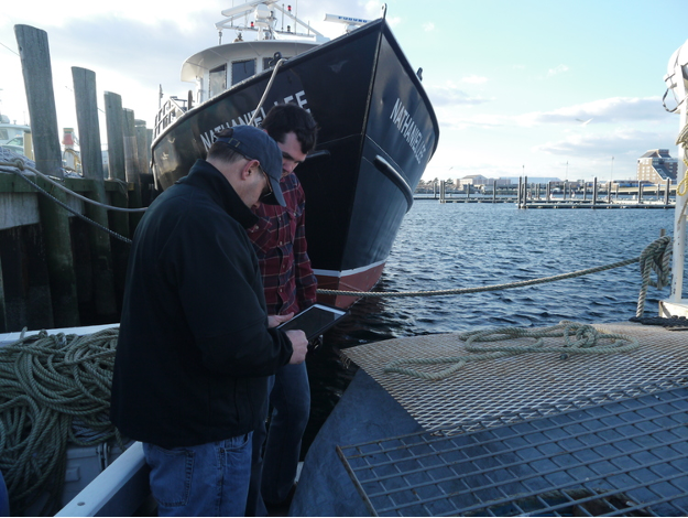 Newport Rhode Island lobsterman James Violet (foreground) reviews oceanographic data collected via CTDs on WHOI provided iPads. Credit: Commercial Fisheries Research Foundation.[/caption]
Gawarkiewicz then went to the Ocean Observatories Initiative data portal and made plots that confirmed the existence of high-salinity surface water near one of Pioneer’s offshore moorings and near the seafloor of one of the array’s inshore moorings. The conditions, he said, were very much like an event in January 2017 in which fish normally associated with warm Gulf Stream waters were caught near Block Island. The event in January 2017 was initially identified in Shelf Research Fleet data and then confirmed in Pioneer Array glider data analyzed by Robert Todd of WHOI.
Acting on the solid relationship built between WHOI and the CFRF, Gawarkiewicz emailed CFRF staff to warn them that conditions were changing and that they should be on alert for changes in the fishery. Shortly after, he received a phone call from Shelf Fleet collaborator, Aubrey Ellertson, who had reported that fishers were noticing an increase in water temperature on the bottom of the seafloor, and an impact on their catch. For some fishers, the Jonah crab fishing declined, and for others they were not seeing traditional fish species caught in their gillnets.
This exchange highlights the strong partnership between WHOI and the Rhode Island fishing fleet. The collaboration has helped participating fleet members recognize oceanographic processes and relate their fishing catch to processes discussed with WHOI scientists like Gawarkiewicz, and his colleagues Magdalena Andres, Ke Chen, and Massachusetts Institute of Technology/WHOI Joint Program graduate Jacob Forsyth. At the same time, Gawarkiewicz and his team have learned from the fishing community about the impacts of warm core rings on species distribution, their catch and, more broadly, on the shelf ecosystem.
“I knew to pass along this alert because members of the Shelf Research Fleet have taught me about what fishing outcomes are likely from some changing ocean conditions,” said Gawarkiewicz. “It is truly remarkable how much we have been able to learn from each other.”
Gawarkiewicz believes that this event demonstrates both the practical and intellectual value of the Pioneer Array data in improving understanding of sub-surface exchange processes. “Without Pioneer, we would not know the bottom salinity nor been able to give the fishers a heads-up as to what to expect. This shows how Pioneer is having a direct impact on how, when, and where people are fishing.”
To hear an audio piece with interviews with Gawarkiewicz, Aubrey Ellertson and others, listen here.
Read More
January 31 Deadline for Applications to Consider Pioneer Array Relocation
Apply to select the next location of the OOI Pioneer Array
Applications are due on January 31st!
The Ocean Observatories Initiative Facilities Board (OOIFB) and the National Science Foundation (NSF) have launched a process to consider whether to move the Pioneer Array from its current location, on the New England shelf and slope south of Martha’s Vineyard, to a new location. Selection of the next OOI Pioneer Array location, or decision to maintain the Array at its current location, will be driven by community input on the important science questions that can be addressed by the Pioneer Array.
The OOI community is invited to weigh in on this important decision during a two-phase sequential lab approach that will bring scientists, educators, and other stakeholders together virtually to evaluate 1) future location options for the Pioneer Array and 2) new design considerations that can enable exciting research endeavors at the chosen location.
Two Innovations Labs will be held in 2021. The Phase 1 Innovations Lab, March 15-19, will explore possible locations for the Pioneer Array based on scientific questions that require an ocean observatory to advance knowledge. At the Lab, interdisciplinary teams will work together to ideate and develop a roadmap of possible locations including exploring new scientific, educational, and partnership opportunities.
The Phase 2 Innovations Lab, in late spring/early summer, will come up with a plan to maximize the science gains and broader impacts of the potential new site. If a new site is recommended, the Array would be moved in 2023.
How to become involved
For those interested in learning more, please visit the OOIFB webpage regarding the Pioneer Array location selection process. The webpage includes a link to the application form to participate in the Phase 1 Innovations Lab. The application deadline is 31 January 2021. Selected Innovations Lab participants will be announced in mid-February.
More information or to apply, please visit here.
Read MoreShould the Pioneer Array be moved? If so, where?
In 2021, the Ocean Observatories Initiative Facilities Board (OOIFB) and the National Science Foundation (NSF) are launching a process to consider whether to move the Pioneer Array from its current location, on the New England shelf and slope south of Martha’s Vineyard, to a new site. Selection of the next OOI Pioneer Array location, or decision to maintain the Array at its current location, will be driven by community input on the important science questions that can be addressed by the Pioneer Array.
The OOI community is invited to weigh in on this important decision during a two-phase sequential lab approach that will bring scientists, educators, and other stakeholders together virtually to evaluate 1) future location options for the Pioneer Array and 2) new design considerations that can enable exciting research endeavors at the chosen location.
Two Innovations Labs will be held in 2021. The Phase 1 Innovations Lab, March 15-19, will explore possible locations for the Pioneer Array based on multiple factors, driven by scientific questions that require an ocean observatory to advance knowledge. At the Lab, interdisciplinary teams will work together to ideate and develop a roadmap of possible locations including exploring new scientific, educational, and partnership opportunities.
The Phase 2 Innovations Lab, in late spring/early summer, will come up with a plan to maximize the science gains and broader impacts of the potential new site. If a new site is recommended, the Array would be moved in 2023. The OOI Coastal and Global Scale Nodes (CGSN) Team at Woods Hole Oceanographic Institution would continue the operation and maintenance of the array, regardless of its location.
The Lab’s findings will be considered by an NSF review panel, which will report to NSF in early fall on the new Pioneer Array location and how it can be optimized for science and education.
How to Become Involved
For those interested in learning more, a 60-90-minute informational session, Phase 1 Micro Lab, is planned for 13 January 2021, beginning at 1 pm Eastern. Representatives from NSF along with CGSN, the current operator of the Pioneer Array, will present information about the selection process and technical details about the Pioneer Array.
Individuals interested in applying for the Phase I Innovations Lab are encouraged to attend the Micro Lab. The information provided could be useful in submitting an application. To attend the Phase 1 Micro Lab, please RSVP here.
The application to participate in the Phase 1 Innovations Lab is available here. The application deadline is 31 January 2021.
Selected Innovative Lab participants will be announced in mid-February. Participants selected for Phase I will also be considered for Phase II.
What to Expect
The Innovations Labs will bring together scientists, stakeholders, and educators. Interdisciplinary teams will work together for six-hour days for the full week. Teams will form, pitch, and refine plans (based on input from experts and other participants). Participants will meet virtually each day of the week (M-F). Four days will be for synchronous meetings and one day will be dedicated to asynchronous team work
To learn more or to apply, click here.
Read More
Potential Relocation of the OOI Pioneer Array Discussion 8 Dec
The National Science Foundation (NSF) will present plans to use an “Ideas Lab”, a participatory, immersive process designed to innovative the decision-making process for the potential move of the Ocean Observatories Initiative (OOI) Pioneer Array at the American Geophysical Union Fall Meeting. The presentation will be at the OOI virtual booth, on 8 December 11:15-noon Eastern. Lisa Clough, Section Head from NSF’s Division of Ocean Sciences, will describe the “Ideas Lab” process that will be used to determine if the Pioneer Array should be moved, and if so, to what location. She will be joined by Al Plueddemann, Project Scientist for OOI’s Coastal and Global Scale Nodes, who will speak to the operational considerations involved in a potential move of the Pioneer Array.
The Coastal Pioneer Array is currently located in the Middle Atlantic Bight, centered about 75 nautical miles south of Martha’s Vineyard, where the continental shelf-slope is highly productive. The area was chosen as the initial placement of the Pioneer Array to examine exchanges between the shelf and slope and the shelf ecosystem and provide insight into air-sea gas exchange, including carbon dioxide absorption. From the outset, NSF has committed to re-evaluating the placement of the Pioneer Array every five-to-seven years.
“Ideas Lab are designed to bring together people to innovate and invigorate their scientific and educational approaches. We hope by using this participatory process, current and future users of OOI data will deeply explore the opportunities of having an open-data real-time coastal ocean array in various locations within the US EEZ,” explained Clough. “It is our hope that by collectively considering what the optimal location for the Pioneer Array is, and to a certain extent what types of data will be collected and how, the decision-making process will also encourage new thinking.”
Plueddemann, who has been involved with 15 successful missions to recover and deploy equipment at the Pioneer Array, will introduce some of the technological, logistical and environmental considerations inherent in a decision to relocate the array.
“My role in this decision-making process is solely as an information broker,” explained Plueddemann. “Neither I nor anyone involved in the current Pioneer Array team will be involved in the process of deciding how and where the Pioneer Array might be relocated. Our role will be to inform and advise on the feasibility of different concepts.”
Regardless of the location decision, the current team at Woods Hole Oceanographic Institution will continue to operate the Pioneer Array. Their formal role as operators of the Array entails expertise in the deployment, recovery, and maintenance of the equipment.
REGISTER NOW!
Potential Relocation of the Pioneer Array: Participate in the Process
8 December from 11:15 am-noon
Read More
Rolling Seas, Followed by Blue Skies During Pioneer 15
The weather for the 15-day Pioneer 15 expedition aboard the R/V Neil Armstrong came in like a lion and left like a lamb. As the ship departed the Woods Hole dock on 28 October, the sky was gray, the air damp, and the forecast foreboding as the 10- member scientific team and the crew of the R/V Neil Armstrong headed toward the Pioneer Array, about 75 nautical miles south of Martha’s Vineyard.
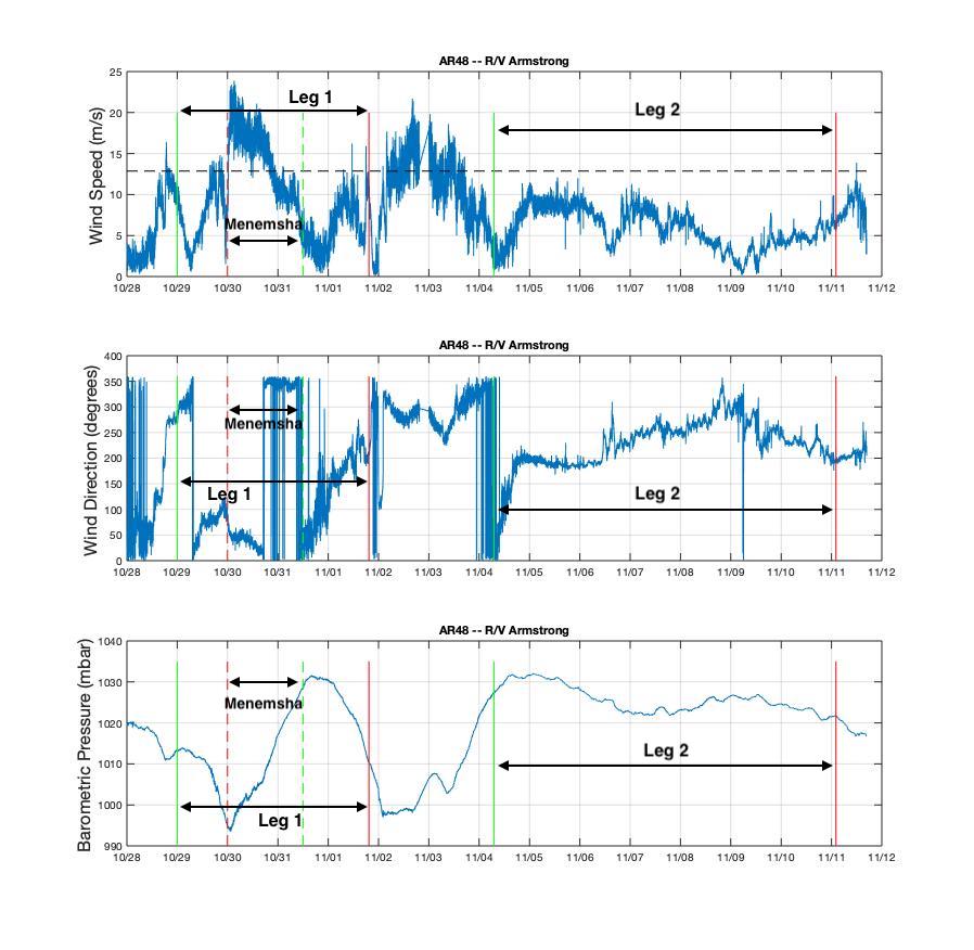
During Leg 1, the ship had some rocky days and briefly sought the protection of Menemsha Bight on the northwest side of Martha’s Vineyard as Tropical Storm Zeta passed through and brought her fury with her. Leg 2 of the journey brought with it clear skies and smooth sailing. The following shows the wind and pressure data from the ship throughout the Pioneer 15 cruise.
[media-caption path="/wp-content/uploads/2020/11/AR48_Weather-1_annotated.jpg" link="#"]Wind speed, direction, and barometric pressure from the met mast of the R/V Neil Armstrong. The green lines indicate when the ship arrived at the Array, the red lines show when it departed. The solid lines are for Leg 1 and Leg 2, and the dashed lines are the excursion to Menemsha in Leg 1. Credit: Sheri N. White (WHOI)[/media-caption]
Chief Scientist Sheri N. White said, “Despite the difficult weather, we had a very successful mission. The team recovered and deployed three coastal surface moorings and a profiler mooring, and deployed two winter coastal profiler moorings. We also were able to recover three gliders, and collect shipboard and CTD data in the vicinity of the Array. We planned on a bit of flexibility in the schedule due to the late fall departure, which always brings with it unpredictable conditions.”
The expedition was conducted in two legs because all of the moorings could not be accommodated on the ship at the same time. The Team returned to home port at the conclusion of the cruise on 11 November, when they disembarked after a month of being either in isolation or at sea away from friends and family.
The recovered moorings are now undergoing refurbishment onsite at WHOI so they will be ready for the next equipment turn in spring 2021. Next on tap for the Pioneer Array is the deployment of four gliders, Next on tap for the Pioneer Array is the deployment of four gliders, which will be done from a small vessel when the weather allows a safe transit.
Pioneer 15 in Pictures
[media-caption path="/wp-content/uploads/2020/11/DSC_0138-scaled.jpg" link="#"]The Pioneer 15 Team deploys the Central Surface Mooring on Leg 1 in dreary weather. Credit: Dee Emrich©WHOI[/media-caption]
[media-caption path="/wp-content/uploads/2020/11/DSC_0685-scaled.jpg" link="#"]The Pioneer 15 Team recovers the Inshore Surface Mooring. It had been in deployed in the water for 12 months. Credit: Dee Emrich©WHOI[/media-caption]
[media-caption path="/wp-content/uploads/2020/11/IMG_4234-scaled.jpg" link="#"]The Team dressed as oceanographers for Halloween… and deployed the Inshore Profiler Mooring in the few hours of clear skies between two storms at the Pioneer Array. Credit: Sheri N. White©WHOI[/media-caption]
[media-caption path="/wp-content/uploads/2020/11/IMG_4244-scaled.jpg" link="#"]The R/V Neil Armstrong left the WHOI dock on Leg 2 of the Pioneer 15 expedition, with the Central Surface Mooring in position for deployment. Credit: Sheri N. White©WHOI[/media-caption]
[media-caption path="/wp-content/uploads/2020/11/IMG_4245-scaled.jpg" link="#"]The Offshore Surface Mooring is ready for deployment on the stern of the R/V Neil Armstrong on Leg 2. Credit: Dee Emrich©WHOI[/media-caption]
[media-caption path="/wp-content/uploads/2020/11/IMG_4245-scaled.jpg" link="#"]Beautiful weather on Leg 2 made recovering the large surface moorings a bit easier. The surface moorings were deployed for 12 months, rather than six, due to the COVID pandemic. Credit: Jennifer Batryn©WHOI[/media-caption]
[media-caption path="/wp-content/uploads/2020/11/PMOU-16_deploy.jpg" link="#"]This is what a Profiler Mooring looks like during deployment. Profiler Moorings collect data from the entire water column using a McLane Moored Profiler, which crawls up and down the mooring line. Credit: Sheri N. White©WHOI[/media-caption]
[media-caption path="/wp-content/uploads/2020/11/ISSM_Biofouling.jpg" link="#"]This is some of the biology that has taken up residence on the Inshore Surface Mooring during its year-long stay on the Atlantic continental shelf. Credit: Dee Emrich©WHOI[/media-caption]
Read More