
Posts Tagged ‘Gliders’
OOI Contributions Featured at 2025 Slocum Glider User’s Conference & Sentinel Launch

By: Amber Coogan
The global oceanographic community gathered in Woods Hole October 7–9 for the 2025 Slocum Glider User’s Conference. The meeting convened users, scientists, engineers, and mission planners to advance next-generation autonomous ocean observing.
For OOI, the event provided a timely forum to share nearly a decade of experience integrating Slocum gliders into sustained, basin-scale observing. OOI has deployed Slocums to collect high-resolution profiles of temperature, salinity, oxygen, chlorophyll, nitrate, optical properties, and currents across energetic and climatically sensitive regions. These long records (gathered in all seasons and weather) have supported research on boundary currents, carbon cycling, marine heatwaves, ecosystem change, and storm-ocean interaction.
The OOI Team presented two posters at the conference, one documenting eight years of glider operations at the OOI Pioneer New England Shelf Array and the other describing the operational approach and initial outcomes from the Pioneer Mid-Atlantic Bight Array, which was started in April 2004. Diana Wickman presented a talk on “Tips, Tricks and Best Practices” for long-duration glider missions, an area where OOI has unique expertise.
The conference week concluded with the October 10 launch of the Sentinel Mission, the first attempt to autonomously circumnavigate the globe by AUV, using REDWING, a Slocum Sentinel Glider.
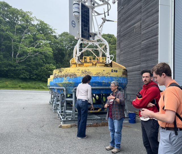
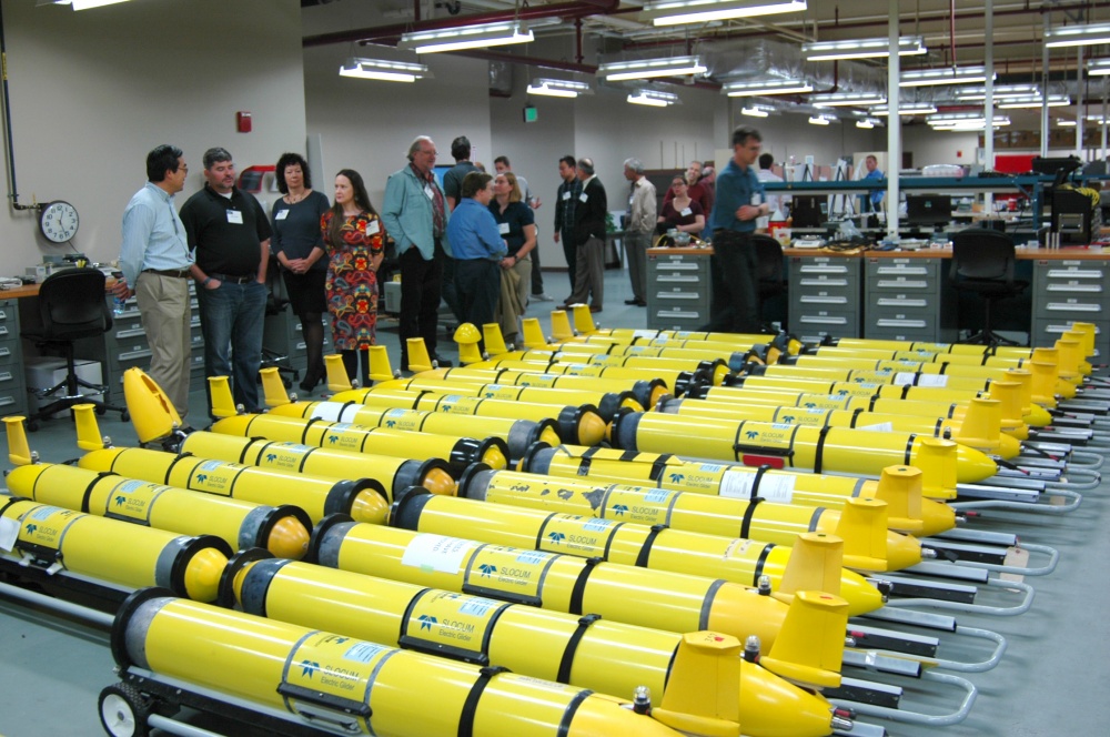
[caption id="attachment_37105" align="alignnone" width="2560"] Diana Wickman (WHOI) gives a tour of the Glider Lab at LOSOS. © Andy Robinson / WHOI[/caption]
[caption id="attachment_37106" align="alignnone" width="2560"] Tour of the Glider Lab at LOSOS. © Andy Robinson / WHOI[/caption]
[caption id="attachment_37101" align="alignnone" width="1920"]
Diana Wickman (WHOI) gives a tour of the Glider Lab at LOSOS. © Andy Robinson / WHOI[/caption]
[caption id="attachment_37106" align="alignnone" width="2560"] Tour of the Glider Lab at LOSOS. © Andy Robinson / WHOI[/caption]
[caption id="attachment_37101" align="alignnone" width="1920"] Peter de Menocal (WHOI) speaks at Sentinel Mission Launch event. © Amber Coogan / WHOI[/caption]
![]()
![]()
Slocum Glider Users Conference
Are you a glider user? Want to learn more about gliders from the user community? The global oceanographic community is invited to participate for FREE in the Slocum Glider User’s Conference, taking place October 7–9, 2025 in Woods Hole. This three-day event will be hosted by TeledyneMarine and bring together Slocum glider users, marine scientists, engineers, and dignitaries for a collaborative exchange of knowledge, innovation, and mission collaboration. WHOI owns and operates the largest civilian fleet of gliders through the Ocean Observatories Initiative Program. This conference is currently open for registration and taking applications for presentations and poster sessions. Go to https://www.teledynemarine.com/gliderusersconference for more information and to register. For questions, please reach out to Leslie-Ann McGee, lmcgee@whoi.edu
Read MoreCC-CREW Students Tour OOI’s LOSOS Facility at WHOI
Last week, OOI hosted a group of students from the Community College Comprehensive Research Experience at WHOI (CC-CREW) for a tour of the Lab for Ocean Sensors and Observing Systems (LOSOS). The visit provided students with an up-close look at OOI equipment, including oceanographic sensors and mooring components, and included discussions about career paths in ocean science and technology.
CC-CREW is a 9-week paid summer program designed to introduce local community college students to STEM pathways (particularly in ocean science and geoscience) through immersive research experiences and facility tours at WHOI. The program also supports students in planning their transition from community college to four-year institutions and how to navigate educational opportunities that lead to careers in STEM and related fields.
Originally created to broaden participation in the geosciences, CC-CREW also serves a critical role in strengthening the local workforce. Many students in the program are passionate about pursuing careers that keep them rooted in the region, and tours like this one at OOI highlight the kinds of impactful, local career paths available in marine science and engineering.
[caption id="attachment_36707" align="alignnone" width="640"] WHOI Principal Engineer Sheri White (center) describes the design and purpose of the instrumented surface buoys (background) used in the OOI Program. Photo courtesy of CC-CREW[/caption]
[caption id="attachment_36708" align="alignnone" width="480"] WHOI Senior Engineering Assistant Diana Wickman (right) describes the capabilities of OOI ocean gliders. Photo courtesy of CC-CREW[/caption]
For more information on OOI ocean gliders click here.
Read MoreUnderwater Glider User Group (UG2) Workshop
Improving Reliability and Availability of Dissolved Oxygen Glider Data
OOI’s Coastal Endurance Array Team is making great strides in ensuring the accuracy of glider dissolved oxygen measurements and making these data readily available to researchers. The team has compared glider oxygen data with independent transects and climatologies compiled by west coast colleagues. They are increasing the number of in situ comparisons of glider oxygen data with bottle samples taken in proximity to the gliders. They have built a benchtop system to do two-point calibrations for oxygen sensors to help ensure their accuracy when the gliders are in the water. And, working with OOI colleagues at WHOI, the team is helping to design and test improved sensor mounts to perform in situ air calibrations of glider oxygen measurements.
“A couple of years ago, Endurance Glider Lead Stuart Pearce developed code to put all of the oxygen data collected by our glider fleet into the DAC, the national central database for glider data,” said Ed Dever, Principal Investigator of the Coastal Endurance Array and Professor at Oregon State University. “Prior to doing this, Stuart examined the data and metadata for any gross errors and issues. That was the first of many steps we have taken to ensure OOI oxygen data are reliable and available so they can be trusted and used by researchers. Our effort is paying off. The glider data available on the DAC are identical to that now available on OOI’s Data Explorer. Endurance glider lines off Newport, OR and Grays Harbor, WA will be the backbone for the northern Californian Current part of the nascent Boundary Ocean Observing Network. The OOI glider lines map seasonal development of hypoxic areas off Oregon and Washington from the coast to the edge of the continental shelf.”
[media-caption path="/wp-content/uploads/2022/11/glider.png" link="#"]More than 137 glider missions have occurred along the Newport and Grays Harbor lines since 2014. Credit: Coastal Endurance Array at OSU.[/media-caption]
Collaborations
Enough oxygen data has been collected and shared in the northeast Pacific that is now possible to make high resolution regional climatologies of temperature, salinity and oxygen. Risien et al. (2022) compiled ~20 years of data taken by Jennifer Fisher (NOAA) and many others, to develop analysis ready transects of water property data off Newport, Oregon. These datasets include both climatologies and individual interpolated, quality-controlled, transect data. The Endurance Team compared glider dissolved oxygen with shipboard CTD samples collected by Fisher along the Newport transect in July 2021. Oxygen measurements from the gliders and CTDs samples compared well and provided confidence that glider and shipboard transects can map hypoxic conditions at comparable resolution and accuracy. Added Dever, “We were able to do a side-by-side comparison of the temperature, salinity, and oxygen data collected by the gliders over our Newport hydrographic line with the CTD data sampled by the Fisher’s team using the R/V Elakha. The comparison was quite good and served to validate the quality of the glider data that are an integral part of the Endurance Array.”
Engineering Solutions
A couple years ago, team member Jonathan Whitefield worked with Scripps Institution for Oceanography to build an oxygen Winkler titration rig so the team can titrate its own oxygen samples. The system can be used both in the lab and onboard to validate glider and moored oxygen data. The titration rig has been used to increase the number bottle samples taken during glider deployments and recoveries and to reduce the time between sample acquisition and analysis.
Building on this, Whitefield and others recently assembled in-house two-point calibration baths for pre- and post deployment of oxygen data collected by gliders and moorings. Calibrations are performed at anoxic and near-saturated conditions. The two-point calibration system is based on a similar one used at Scripps Institution for Oceanography (López-García, P., et al., 2022). A sodium sulfite solution is injected into bottle samples to get the low endpoint oxygen calibration point. The high endpoint oxygen calibration point is achieved using a stirred bath at 10°C to get to near saturation. The high endpoint oxygen is measured with replicate Winkler titrations. The calibration baths better ensure accuracy by making it possible to perform routine in-house checks of vendor calibrations on glider and moored sensors as well as identify calibration drift after deployment.
What’s ahead
Oxygen data are reviewed weekly by operators and annotated. Real-time automated quality control using QARTOD tests is in development. In-situ air calibration tests of oxygen optodes are planned for spring 2023. At the suggestion of outside investigators, OOI’s Coastal and Global Scale Node team at Woods Hole Oceanographic Institution modified Slocum glider optode mounts to allow in-situ air calibrations of dissolved oxygen on the Irminger Sea and Pioneer Arrays. The mount, however, affected the flow around gliders with radome fins and caused navigation problems. Modeling done at WHOI showed these problems may be due to vortices of the optode on the starboard side of the fin. The Endurance gliders will test a new mount placement during its upcoming bi-annual operations and maintenance cruise in March of 2023.
“We’re part of the community of practice for glider oxygen calibration and validation,” said Dever. “We engage with colleagues, adopt standard practices and widely share data. This community of users will help all of us get a better handle on ongoing changes in our ocean regions.”
References
Risien et al. (2022) Spatially gridded cross-shelf hydrographic sections and monthly climatologies from shipboard survey data collected along the Newport Hydrographic Line, 1997–2021, https://doi.org/10.1016/j.dib.2022.107922
López-García, et al. (2022) Ocean Gliders Oxygen SOP, Version 1.0.0. Ocean Gliders, 55pp. DOI: http://dx.doi.org/10.25607/OBP-1756. (GitHub Repository, Ocean Gliders Oxygen SOP.
Read More
Canadian and OOI Gliders Meet in Pacific
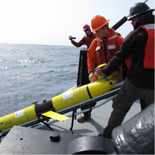
In an important collaborative undertaking, the Ocean Observatories Initiative (OOI) Glider 363 and a Fisheries and Oceans Canada (DFO) Glider crossed paths along Line P, a transect line in the northeast Pacific. This modern day “intersection” provides an opportunity for scientists to have co-located science profiles to match up with sensor data, but also an efficient way to extend data about ocean conditions along Line P throughout the year.
Line P consists of 27 stations extending from Vancouver Island to Ocean Weather Station Papa (OWSP), also known as “Station Papa.” OSWP (located at 50°N, 145°W) has one of the oldest oceanic time series records dating from 1949-1981. This 32-year-old record is supplemented by data collected by shipboard measurements along Line P conducted by DFO three times/year. The US National Oceanic and Atmospheric Administration also has a surface mooring at Station Papa, which contributes year-round data to this important record. Beginning in 2014, OOI also enhanced Station Papa with an array of subsurface moorings and glider measurements.
An important intersection
[media-caption path="/wp-content/uploads/2022/09/image012.png" link="#"]The OOI glider left from Newport, OR aboard the RV Zephyr and was deployed on July 3 in open ocean over the Juan de Fuca Ridge. The glider transited along Line P to the Papa Array starting from station P16. A DFO glider was traversing Line P at the same time, providing an opportunity for US and Canadian scientists to have co-located profiles to match up with sensor data. [/media-caption]The DFO glider was deployed in late May returning from OWSP. The OOI glider left from Newport, OR aboard the RV Zephyr and was deployed on July 3 at 46 N 130W in open ocean over the Juan de Fuca Ridge. The glider transited along Line P to OOI’s Global Station Papa Array starting from station P16, which is in international waters just outside the Canadian EEZ. A DFO glider was traversing Line P at the same time, providing an opportunity for US and Canadian scientists to have co-located profiles to match up with sensor data.
At the point of the cross-over the OOI glider had been at sea for about 40 days. Both OOI’s and DFO’s glider have very similar sensors onboard that measure temperature, salinity, pressure, oxygen, optical backscatter, chlorophyll, and colored dissolved organic matter. These measurements when compared to historical data provide insight into existing and possibly changing conditions in the water column.
“At a very basic level these deep-ocean rendezvous provide us with an opportunity to compare the sensor data mid-deployment, instead of just at the start or end of their respective deployments. This can help us look for any trends or offsets that might indicate sensor issues – such as aging, fouling, and other issues that may impede performance. This information helps people understand and be able to use data from these gliders,” explained Peter J. Brickley, OOI’s Glider Lead. “The other outcome is that our joint glider data can contribute extra sampling along Line P. While there are several cruises along this line every year, those efforts are spaced far apart in time (sometimes several months). Autonomous gliders can fill some of the gaps, are relatively inexpensive to operate, and can help better delineate conditions, including changing anomalies as they occur.”
Another contributing factor to making this initial glider cross-over a useful test case is that a scheduled DFO Line P cruise on the Canadian Coast Guard Ship John P. Tully was happening concurrently along Line P. The team aboard the Tully started sampling in early August and are scheduled to complete sampling by the month’s end. The ship collected some data in the vicinity of both gliders, offering another opportunity to compare and contrast data.
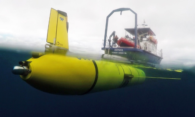
[media-caption path="/wp-content/uploads/2022/09/zephyr2.png" link="#"]The OOI glider deployed from the R/V Zephyr heading north to reach Line P in time to cross-over with DFO’s glider to share and contrast data collected. Credit: R/V Zephyr ©WHOI. [/media-caption]While the glider cross-over is an important first, it is emblematic of the ongoing cooperative effort between the Canadian DFO, NOAA, and OOI teams sampling in this important region. Communications occur regularly between OOI team members and the Chief Scientist conducting DFO shipboard sampling, as well as between OOI and NOAA personnel.
Added Brickley, “This recent excursion along Line P was planned, but also a serendipitous opportunity that could be leveraged quickly. Once we all have the chance to assess the data provided, we’ll be in a better position to explore making this a more regular occurrence. If it turns out that our sampling schemes are easily aligned, that could be another step to help advance understanding of ocean processes from coastal, eutrophic waters into the heart of the high nitrate, low chlorophyll area of the NE Pacific.”
Read More
Testing of New Glider Models Underway
Last fall, the Coastal Endurance team conducted an initial test run of a Slocum G3 glider to determine its capabilities and operational differences to the G2 glider, currently used by the Endurance and Coastal & Global Scale Nodes (CGSN) teams. The test was prompted by glider vendor Teledyne’s announcement that it would no longer support the G2 glider past 2023.
Both the Endurance and CGSN teams have since expanded testing. The Endurance team recently completed a two-month deployment of a G3 glider, with plans to deploy another later this summer. The CGSN team, which operates the Pioneer and two global arrays, is testing three G3 gliders. One is being tested for use as a coastal glider at the Pioneer Array and the other two are being configured for the Irminger Sea and Station Papa global sites.
“Recent testing at the Pioneer Array was really valuable for us,” said Peter Brickley, CGSN Observatory Operations Lead. “We got a chance to see that our missions were workable, we found and made the changes that were needed, and we were also able to get a better estimate of how much energy these things were going to use.”
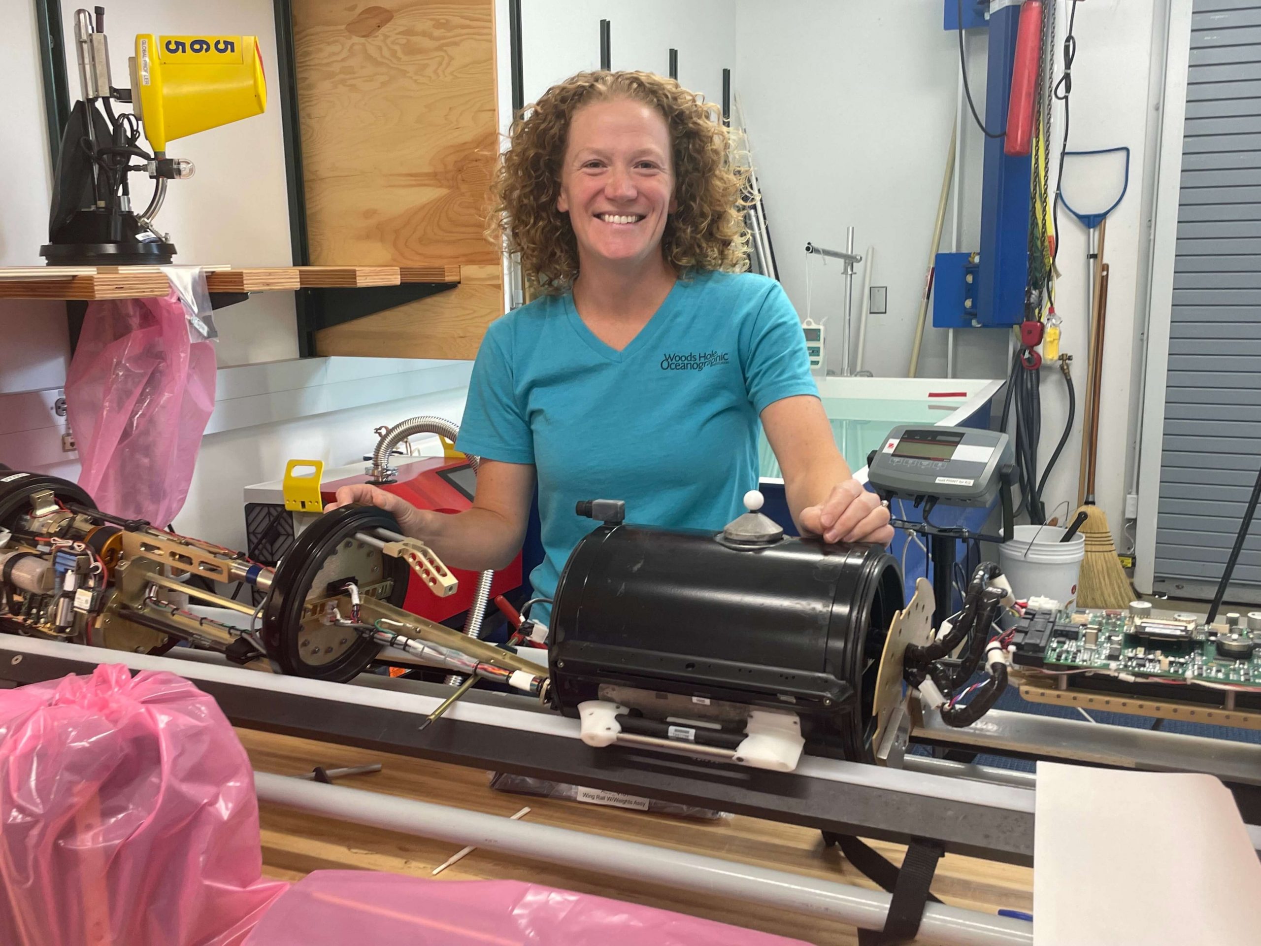
[media-caption path="https://oceanobservatories.org/wp-content/uploads/2021/07/IMG_3107-2-1-scaled.jpg" link="#"]Diana Wickman of the CGSN team at Woods Hole Oceanographic Institution is responsible for keeping the CGSN gliders operational. Here she has stripped the exterior of the glider to ensure that all internal parts are functional. Once refurbished, the gliders are tested in a water tank before being deployed at sea. Credit: Jade Lin ©WHOI.[/media-caption]The G3 gliders use more power than the G2 gliders, so the logistics of when and where they are deployed will require some adjustments. When powered by primary lithium batteries, for example, the G2 gliders can be deployed for about 90 days. The initial tests of the G3 gliders showed they could last in the water for around 75 days using primary lithium batteries. For trial runs using rechargeable batteries, the time in the water for the G3 gliders was reduced to about 30 days.
OOI is working with the vendor to evaluate operational alternatives to extend the operating window of the G3 gliders.
Improvements may require tweaking
“The rechargeable batteries are a really cool feature, but because they are about half of the energy density of the usual batteries, we’re going to have to adjust sampling schemes and plans for time in the water when we use the rechargeable batteries,” said Stuart Pearce, who works with the Endurance gliders. For now, the Endurance team intends to test the rechargeable batteries in the near shore gliders in the spring and summer when they can reliably get out to sea to recover and deploy the gliders.
G3 gliders also come equipped with larger volume buoyancy pumps than the G2 models in response to users’ feedback. “The gliders rise and fall in the water column by changing their volume and therefore density,” explained Pearce. “The new gliders have 800-1000 cubic centimeters of fluid volume to rise and dive with, compared to the 500 cubic centimeters of volume in the G2 gliders. This means that the G3 gliders can climb and dive in a greater buoyancy range.” One option being explored is whether power consumption can be reduced by adjusting the volume of the reservoir fluid needed to make the glider rise and fall.
The new G3 gliders incorporate some changes that address feedback from OOI and other users who have operated G2 gliders. “If you put anything in the ocean and use it as much as we do, you will find things that unexpectedly fail,” said Peter Brickley, CGSN Observatory Operations Lead. “We’ve been operating gliders since 2013, so we have lots of experience. In the early days, for example, we had a lot of problems with the digifin, the steering rudder that’s on the back of the vehicle. We worked closely with Teledyne to document and study this issue and they ultimately made needed improvements.” Other issues have been similarly addressed over the years.
Integrating the new G3 gliders into its Global Arrays may offer greater reliability as older G2 models are phased out. Diana Wickman, Senior Engineering Assistant II at Woods Hole Oceanographic Institution who keeps the CGSN gliders operational, explained “We need the equipment to work really well, and it needs to work for the entire year. At Pioneer, if we have problems, we can replace vehicles that are struggling with vehicles that we can refurbish in-house, but we simply can’t do that at the global sites.”
For now, the teams will continue with testing to make sure the new gliders will work for OOI’s purpose of long-term ocean monitoring.
OOI shares its glider data with the Integrated Ocean Observing System (IOOS) Glider Data Assembly Center and the OceanGliders project, which is a part of the Global Ocean Observing System (GOOS). Both serve as repositories for researchers interested in using glider data.
Read More
OOI Operations Manager Attends US Glider Workshop
In January, the OOI Operations Manager, Thomas Wims, attended the two-day US Underwater Glider Workshop at the INFINITY Space Center in Mississippi, hosted by the Interagency ocean Observation Committee (IOOC). Over 90 people were in attendance from approximately 40 organizations representing universities, federal government agencies, nonprofits, industry, and the US Navy.
The focus of the workshop was to facilitate the sharing of best practices of glider operations across programs. Most programs in attendance had three or fewer gliders. This meeting provided a key avenue for these smaller groups to seek guidance from industry as well as organizations with larger fleets, like the US Navy, the OOI, and Rutgers University.
“With the second largest glider fleet in the nation, we were thrilled to be asked to come to the table during this workshop,”says Thomas Wims, OOI Operations Manager. “It is important to share what we know and what we have learned over the last several years of deploying and maintaining our glider fleet. A key element of the OOI is to foster collaborations, share best practices, and provide access to data.”
The OOI has 64 total gliders in its fleet, with up to 32 deployed at any time. These gliders are located at the two Coastal Arrays as well as at the four high latitude, open ocean sites of the Global Arrays. More information on OOI Gliders, can be found on the OOI Website.
One of the take homes from the workshop was the need to share more glider data across organizations, to break down the silos of data collected and stored at individual organizations. Participants discussed how critical it is to share data across similar regions, gaining a broader view of the water environments. OOI glider data are currently publicly available through the OOI Data Portal, as well a part of the growing Glider DAC resource collated by the Integrated Ocean Observing System (IOOS).
Read More