
Posts Tagged ‘Global Station Papa’
Inside the Role of a Subsurface Mooring Lead
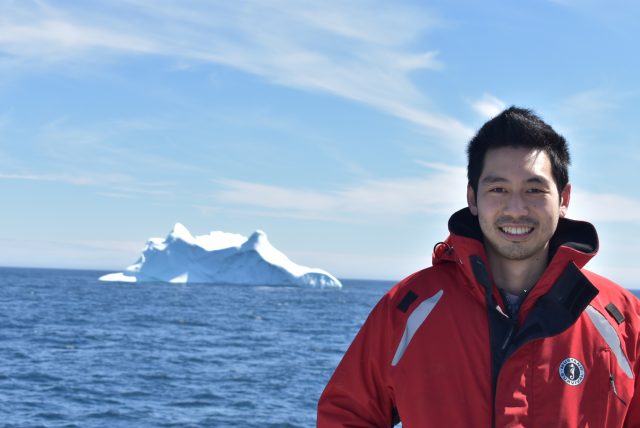
In the demanding field of oceanic exploration, a dedicated team of professionals from the Ocean Observatories Initiative (OOI) conducted the 11th annual cruise to the Station Papa Array in the Gulf of Alaska aboard the R/V Sikuliaq. Central to this mission was James Kuo, a Subsurface Mooring Lead (SML) at the Woods Hole Oceanographic Institution (WHOI), whose responsibilities were crucial to the voyage’s success.
Key Responsibilities
As the SML, James Kuo manages two flanking moorings and one hybrid profiler mooring. His primary responsibility is to ensure all instruments are fully operational before, during, and after deployment. This involves conducting thorough checks at each stage to confirm the equipment is in optimal condition for the year-long deployment. Occasionally, he must also address any issues that arise during deployment before leaving the array site, ensuring everything is functioning as intended.
During deployment, James primarily monitors engineering metrics, such as power consumption, to evaluate the health of the moorings. He also reviews scientific data—including pressure, temperature, and current velocities—to assess the moorings’ status and ensure that the instruments are positioned at the correct depths. This thorough approach provides a complete understanding of both instrument performance and the environmental conditions affecting the moorings.
When James and his team retrieve previously deployed moorings, they carefully inspect the instruments and analyze the data to identify any failures and determine their causes. Significant findings are annotated in the data stream to help scientists understand any anomalies during processing. Depending on the nature of a failure, these insights may lead to procedural changes or design modifications to improve future deployments.
Veteran of the Seas
James is well-versed in life at sea, having participated in approximately 28 cruises throughout his career. James is well-known for his ever-present smile while working to overcome daily challenges aboard the ship. Over his nine years at WHOI, he’s had the opportunity to explore diverse and exotic locations, including the Arctic, Norway, Italy, Chile, Uruguay, Iceland, Alaska, and various other domestic ports. Each expedition offers him a unique travel experience, venturing to places that are often beyond the reach of most travelers.
Career Development
James’s career in oceanography began in college as an intern at Scripps Institution of Oceanography where he assisted with various tasks and mooring assemblies. After graduating from University of California, San Diego (UCSD) with a degree in Structural Engineering, he joined Scripps full-time, focusing on mechanical design of moorings using CAD software.
During the first OOI Southern Ocean cruise in 2015, James collaborated with the WHOI team responsible for deploying the OOI Surface Mooring. A year later, WHOI recognized James’s expertise and offered him a position to continue his work with OOI. He focused on Subsurface Moorings, where he eventually became an expert in the field, mastering the intricacies of Subsurface Mooring platforms.
Future Aspirations
As the SML on the Papa expedition, James tackles a wide range of tasks and responsibilities, offering both significant challenges and rewarding opportunities. His journey from intern to Research Engineer reflects the dedication and expertise that have allowed him to excel in oceanographic research.
Looking forward, James sees significant growth opportunities at WHOI. He recently secured funding for a proposal to develop a mixed reality system for underwater ROVs, a project that is already underway. “The diverse projects and innovative opportunities offer the potential for a fulfilling and dynamic career,” said James.
[caption id="attachment_34599" align="alignnone" width="640"] James Kuo, Research Engineer[/caption]
Read More POGO Fellow Aditi Sharma Returns from Sea and Reflects on 17-Day Expedition
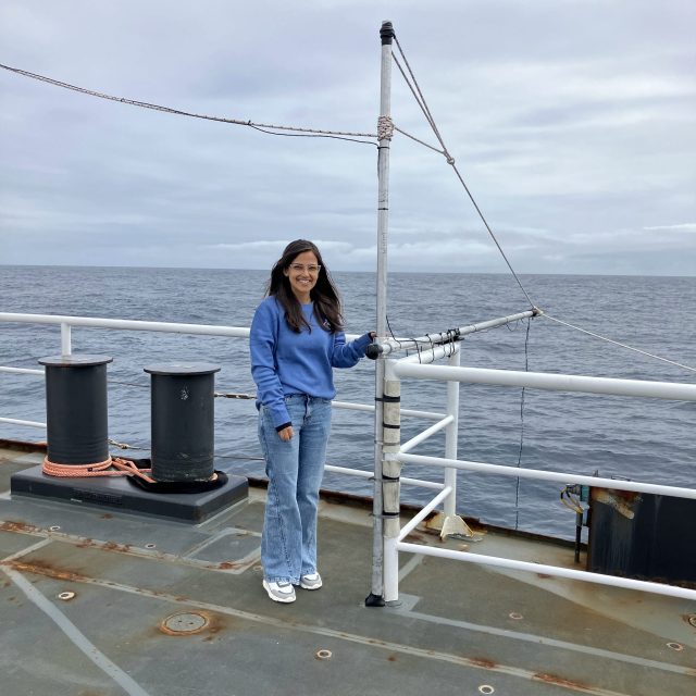
Partnership for Observation of the Global Ocean (POGO) Fellow Aditi Sharma has returned from a 17-day expedition aboard the R/V Sikuliaq to recover and deploy OOI’s Global Station Papa in the Gulf of Alaska. A PhD candidate at the National Institute of Oceanography India, Aditi was chosen from over 80 applicants for a shipboard training fellowship sponsored by POGO, WHOI, OOI, and the Nippon Foundation.
Back on land, Aditi is reflecting on her time at sea and her goals for the future.
How did you benefit from the training?
The training has been immensely beneficial as it provided me with a chance to engage in work and learn from the experts in the field. The hands-on operations of winch, deployment procedures, data downloading, and calibration techniques have given me confidence in practical skills essential for the fieldwork. These experiences are particularly relevant as I now intend to apply them to my current project at my parent institute, which involves monitoring diverse environmental variables in the coastal Bay of Bengal using advanced meteorological sensors on a fixed mooring buoy. This training has helped in enhancing my capability to contribute meaningful insights to the project. In addition to the scientific aspects, the training has provided me with an understanding of the operational challenges during expeditions. It has highlighted the need for improvisation in adverse weather conditions and emphasized collaborative work approaches. Additionally, it has instilled in me a strong sense of time management that I aim to apply both in my career and in my personal life.
What are your future aspirations?
I am currently working towards my PhD at the National Institute of Oceanography. Upon completing my PhD, I aim to pursue postdoctoral studies and collaborate with fellow scientists in my specialized field. This journey represents a vast ocean of knowledge that I am eager to explore, with a strong desire to effectively share and discuss my insights with peers.
[caption id="attachment_34524" align="alignnone" width="640"] Aditi Sharma aboard R/V Sikuliaq[/caption]
Read More
Aditi Sharma aboard R/V Sikuliaq[/caption]
Read More Tenth Turn of Global Station Papa Array
The Global Station Papa Array is in the Gulf of Alaska at a critical region of the northeast Pacific Ocean. The region is extremely vulnerable to ocean acidification, has a productive fishery, low eddy variability, and is impacted by the Pacific Decadal Oscillation, often described as the as a long-lived El Niño-like pattern of Pacific climate variability.
A team of 10 scientists and engineers from Woods Hole Oceanographic Institution (WHOI) and the University of Washington will be onboard the R/V Sikuliaq for 15 days in May to ensure that this Array continues to provide data from this important region. The team will deploy three OOI moorings, two open ocean gliders, and one profiling glider. A waverider mooring, which measures wave height and direction, will be deployed for the University of Washington. During the expedition, the team also will be conducting water sampling during recovery and deployments, and sampling while underway for instrument calibration purposes.
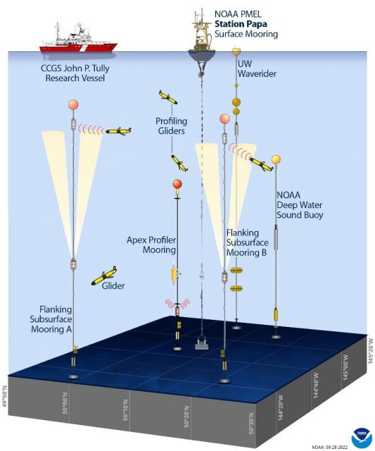
Located next to the NOAA Pacific Marine Environmental Laboratory (PMEL) Surface Buoy and deep-water sound buoy, the Station Papa Array is an important contributor to a cooperatively studied region. The University of Washington operates a waverider mooring near the buoys. The US Coast Guard’s Research Vessel John P. Tully regularly collects data in the region. And the Department of Fisheries in Canada operates a glider line in the region.
[media-caption path="https://oceanobservatories.org/wp-content/uploads/2023/05/CGSN_Papa-10_IRR_Presentation_2023-05-01.jpg" link="#"]The Global Station Papa Array and complementary components. Credit Sarah Battle, NOAA/PMEL, adapted from OOI.[/media-caption]This annual spring “turn” of the Array is no small undertaking. A successful turn requires months of equipment preparation and testing. After all instrumentation has been cleared to go, it is then shipped from Woods Hole Oceanographic Institution to Seward Alaska, where it is again tested as the moorings are assembled for loading onboard the Sikuliaq. Loading is complex, as well. All deck space is fully utilized and when loading is complete, 106,340 pounds of equipment will have been moved onto the ship.
“We have a good, experienced team and the Sikuliaq captain and crew couldn’t be better, “said Kris Newhall, Senior Project Manager at WHOI and Chief Scientist for Station Papa 10. “Our work in this region is really important for the data being generated are helping scientists to understand primary production, marine heat waves, and a whole lot more.”
Regular updates from the Station Papa 10 expedition will be reported here. Bookmark the page and follow along.
Read MoreCanadian and OOI Gliders Meet in Pacific
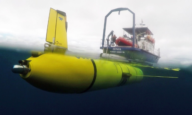
In an important collaborative undertaking, the Ocean Observatories Initiative (OOI) Glider 363 and a Fisheries and Oceans Canada (DFO) Glider crossed paths along Line P, a transect line in the northeast Pacific. This modern day “intersection” provides an opportunity for scientists to have co-located science profiles to match up with sensor data, but also an efficient way to extend data about ocean conditions along Line P throughout the year.
Line P consists of 27 stations extending from Vancouver Island to Ocean Weather Station Papa (OWSP), also known as “Station Papa.” OSWP (located at 50°N, 145°W) has one of the oldest oceanic time series records dating from 1949-1981. This 32-year-old record is supplemented by data collected by shipboard measurements along Line P conducted by DFO three times/year. The US National Oceanic and Atmospheric Administration also has a surface mooring at Station Papa, which contributes year-round data to this important record. Beginning in 2014, OOI also enhanced Station Papa with an array of subsurface moorings and glider measurements.
An important intersection
[media-caption path="/wp-content/uploads/2022/09/image012.png" link="#"]The OOI glider left from Newport, OR aboard the RV Zephyr and was deployed on July 3 in open ocean over the Juan de Fuca Ridge. The glider transited along Line P to the Papa Array starting from station P16. A DFO glider was traversing Line P at the same time, providing an opportunity for US and Canadian scientists to have co-located profiles to match up with sensor data. [/media-caption]The DFO glider was deployed in late May returning from OWSP. The OOI glider left from Newport, OR aboard the RV Zephyr and was deployed on July 3 at 46 N 130W in open ocean over the Juan de Fuca Ridge. The glider transited along Line P to OOI’s Global Station Papa Array starting from station P16, which is in international waters just outside the Canadian EEZ. A DFO glider was traversing Line P at the same time, providing an opportunity for US and Canadian scientists to have co-located profiles to match up with sensor data.
At the point of the cross-over the OOI glider had been at sea for about 40 days. Both OOI’s and DFO’s glider have very similar sensors onboard that measure temperature, salinity, pressure, oxygen, optical backscatter, chlorophyll, and colored dissolved organic matter. These measurements when compared to historical data provide insight into existing and possibly changing conditions in the water column.
“At a very basic level these deep-ocean rendezvous provide us with an opportunity to compare the sensor data mid-deployment, instead of just at the start or end of their respective deployments. This can help us look for any trends or offsets that might indicate sensor issues – such as aging, fouling, and other issues that may impede performance. This information helps people understand and be able to use data from these gliders,” explained Peter J. Brickley, OOI’s Glider Lead. “The other outcome is that our joint glider data can contribute extra sampling along Line P. While there are several cruises along this line every year, those efforts are spaced far apart in time (sometimes several months). Autonomous gliders can fill some of the gaps, are relatively inexpensive to operate, and can help better delineate conditions, including changing anomalies as they occur.”
Another contributing factor to making this initial glider cross-over a useful test case is that a scheduled DFO Line P cruise on the Canadian Coast Guard Ship John P. Tully was happening concurrently along Line P. The team aboard the Tully started sampling in early August and are scheduled to complete sampling by the month’s end. The ship collected some data in the vicinity of both gliders, offering another opportunity to compare and contrast data.
[media-caption path="/wp-content/uploads/2022/09/zephyr2.png" link="#"]The OOI glider deployed from the R/V Zephyr heading north to reach Line P in time to cross-over with DFO’s glider to share and contrast data collected. Credit: R/V Zephyr ©WHOI. [/media-caption]While the glider cross-over is an important first, it is emblematic of the ongoing cooperative effort between the Canadian DFO, NOAA, and OOI teams sampling in this important region. Communications occur regularly between OOI team members and the Chief Scientist conducting DFO shipboard sampling, as well as between OOI and NOAA personnel.
Added Brickley, “This recent excursion along Line P was planned, but also a serendipitous opportunity that could be leveraged quickly. Once we all have the chance to assess the data provided, we’ll be in a better position to explore making this a more regular occurrence. If it turns out that our sampling schemes are easily aligned, that could be another step to help advance understanding of ocean processes from coastal, eutrophic waters into the heart of the high nitrate, low chlorophyll area of the NE Pacific.”
Read More
Station Papa Collaborative Expedition Completed
Ten scientists and engineers. Nineteen days at sea. Approximately 620 nautical miles offshore in the Gulf of Alaska. Six successful mooring deployments — three for the Ocean Observatories Initiative (OOI), two for the National Oceanic and Atmospheric Administration (NOAA), and one for the University of Washington (UW).
The Station Papa 9 team aboard the R/V Sikuliaq demobilized in Seattle, Washington on May 31 after a 19-day expedition to the Global Station Papa Array, in the Gulf of Alaska. In addition to the recovery and deployment of three OOI moorings (Global Hybrid Profiler, two Global Flanking Moorings), the team successfully completed two mooring recoveries and deployments for NOAA (a surface mooring and noise reference station) and UW (a Waverider, which measures surface waves). The team also carried out shipboard underway sampling, including collection of water samples, to support field calibration and validation of the platforms and sensors in the array.
[media-caption path="/wp-content/uploads/2022/05/Picture1.png" link="#"]The Station Papa moorings are outfitted with instruments that measure conductivity, temperature and depth, (CTD) dissolved oxygen, pH, fluorescence, acoustic backscatter (for characterizing zooplankton), and ocean currents. The Hybrid Profiler Mooring contains two Wire-Following Profilers that house instrumentation. The Wire-Following Profiler moves through the water column along the mooring riser, sampling ocean characteristics at a high vertical resolution over a specified depth interval (310-2,100 meters and 2,100-4000 meters deep). The flanking mooring contain instruments fixed at specific depths along the mooring riser to a depth of 1,500 meters.[/media-caption]
“The OOI Station Papa Array was designed knowing that other groups were already contributing substantial assets to the site” said Al Plueddemann, Principal Investigator of the Coastal and Global Scale Nodes (CGSN). “Seeing this collaborative observing effort come together in one joint expedition was gratifying”.
To successfully move around a significant amount of ocean observing equipment involved in six deployments, the team conducted the operation in two stages. The team first deployed the moorings that were loaded onboard the Sikuliaq at Seward, and then retraced their steps to recover the moorings that had been in the water for over a year. (OOI’s global arrays are only turned annually).
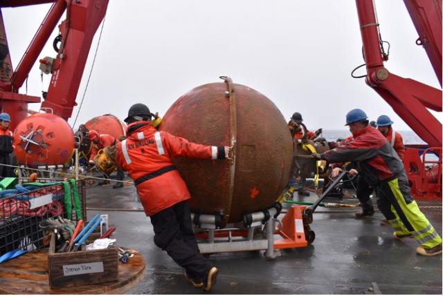
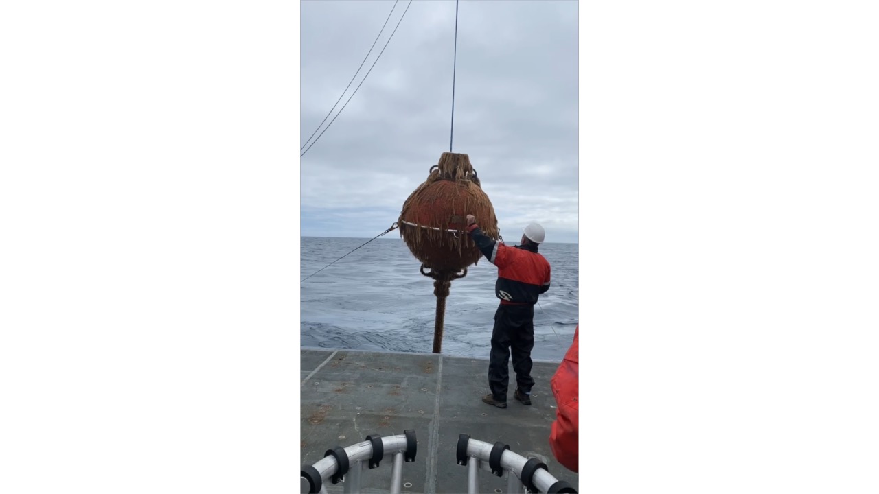
[media-caption path="/wp-content/uploads/2022/05/Picture3-1.png" link="#"]The subsurface moorings at Station Papa have various components all important for the collection of scientific data. The orange spheres provide buoyancy to keep the mooring vertical and instruments at the desired depth. Shown here is the recovery of one of these flotation spheres. Credit: Rebecca Travis ©WHOI.[/media-caption]
Station Papa 9 is the second of three nearly back-to-back recovery and deployment expeditions by OOI’s Coastal and Global Scale Node (CGSN) team this spring. The first was a Pioneer Array expedition, with two legs spanning 8-29 April. The expedition to Station Papa was next. The third after Station Papa is a nearly month-long expedition to the Irminger Sea Array, which will leave the dock in Woods Hole, MA on June 20. Said CGSN Program Manager Derek Buffitt, “Once recovered equipment is brought to shore, we immediately start to tear it down, perform inspections, download data, and start the refurbishment process. Quick turnaround times like we have had this spring, can make it challenging, but our technicians and engineers are up to the task. I am very proud of the work the CGSN team performs onshore and offshore. They are experienced professionals who you can always trust to get the job done.”
More photos and information about the Station Papa 9 expedition can be found at its expedition blog page here. OOI Station Papa data are available from using a variety of access methods described here. The NOAA/PMEL surface mooring is described here, the NOAA Noise Reference Station network is described here, and the UW Waverider is described here.
Read More
Applications Open for June Northeast Pacific OOIFB Workshop
The Ocean Observatories Initiative Facility Board (OOIFB) will host a workshop focusing on current and future science that can be addressed using data from OOI’s infrastructure in the Northeast Pacific and other regional observatory arrays. The workshop will be held at the OSU Portland Center in Portland, OR on June 7-9, 2022. This workshop was scheduled to be held in 2020, but was postponed due to the COVID-19 pandemic. The OOIFB is hopeful that in June 2022 members of OOI’s community can safely come together for a productive workshop. A hybrid model with in-person along with options for virtual participation is planned.
The workshop is aimed at researchers who are using or are considering using OOI data; resource managers from national, state, and tribal agencies; and educators at all levels interested in using data from the OOI’s Regional Cabled, Coastal Endurance, and Global Station Papa Arrays.
The workshop will inform the research community of the available data and science opportunities offered by the OOI and other observatory arrays located in the Northeast Pacific. An overview of OOI data products, user interfaces, and system features will be provided along with hands-on demonstrations using data access tools. OOI Program Team members and NSF representatives will be on hand to answer questions and provide information on OOI operations.
The workshop will provide a forum to facilitate science collaborations, identify strategies for engaging future users of OOI, and build cross-network collaborations. Community-building and expanding broader impacts will be discussed. Workshop participants will have the opportunity to provide feedback on their experiences in working with the OOI systems and data.
To apply for the workshop, please complete the on-line application form that is available on the workshop web page. Please indicate how you plan to participate in the workshop (in person or virtual) when completing the form. Travel support is available, but limited. Broad representation from institutional, geographic, and disciplinary groups is desired and will be considered in participant selection. The deadline for applications is March 20, 2022.
Additional details about the workshop and agenda are available here.
Global Station Papa Team Recovers Two Years of Data
The winds seemed to have blown in favor of the Global Station Papa 8 team last month. Their mission to “turn” (recover old and deploy new) moorings went without incident, and two-years of data were recovered after COVID canceled the 2020 cruise.
On July 18, the seven members of the Station Papa 8 team set out aboard the R/V Sikuliaq from Seward, Alaska following a seven-day COVID isolation period. The weather was beautiful the first three days while in transit to Station Papa, located in the Gulf of Alaska in the Northeast Pacific, and weather remained favorable for work for the rest of the cruise.
Over the 16-day period at sea, the team successfully deployed and recovered two flanking moorings and one hybrid profiler mooring, and deployed and recovered two open ocean gliders. While on station, the team also conducted 11 CTD (conductivity, temperature, and depth) casts that help calibrate the instruments and validate the data they collect.
This eighth turn of the Station Papa Array was particularly important because the annual expedition to turn the array last year was canceled due to constraints imposed by the COVID-19 pandemic. Instrument data are downloaded upon recovery, and following a Quality Assessment/Quality Control (QA/QC) review, nearly two years of ocean observation data may have been recovered. As part of the review, OOI’s Coastal and Global Scale Node team will inspect the instruments for bio-fouling and reagent use to assess whether there was any significant impact to the data.
“We were really pleased to see that the instruments were still collecting and recording data, even after being in the water for almost two years,” said Kris Newhall, chief scientist of the Station Papa 8 expedition. “In spite of limited battery power and challenging conditions, most instruments continued to collect data for the duration of the two-year extended deployment.”
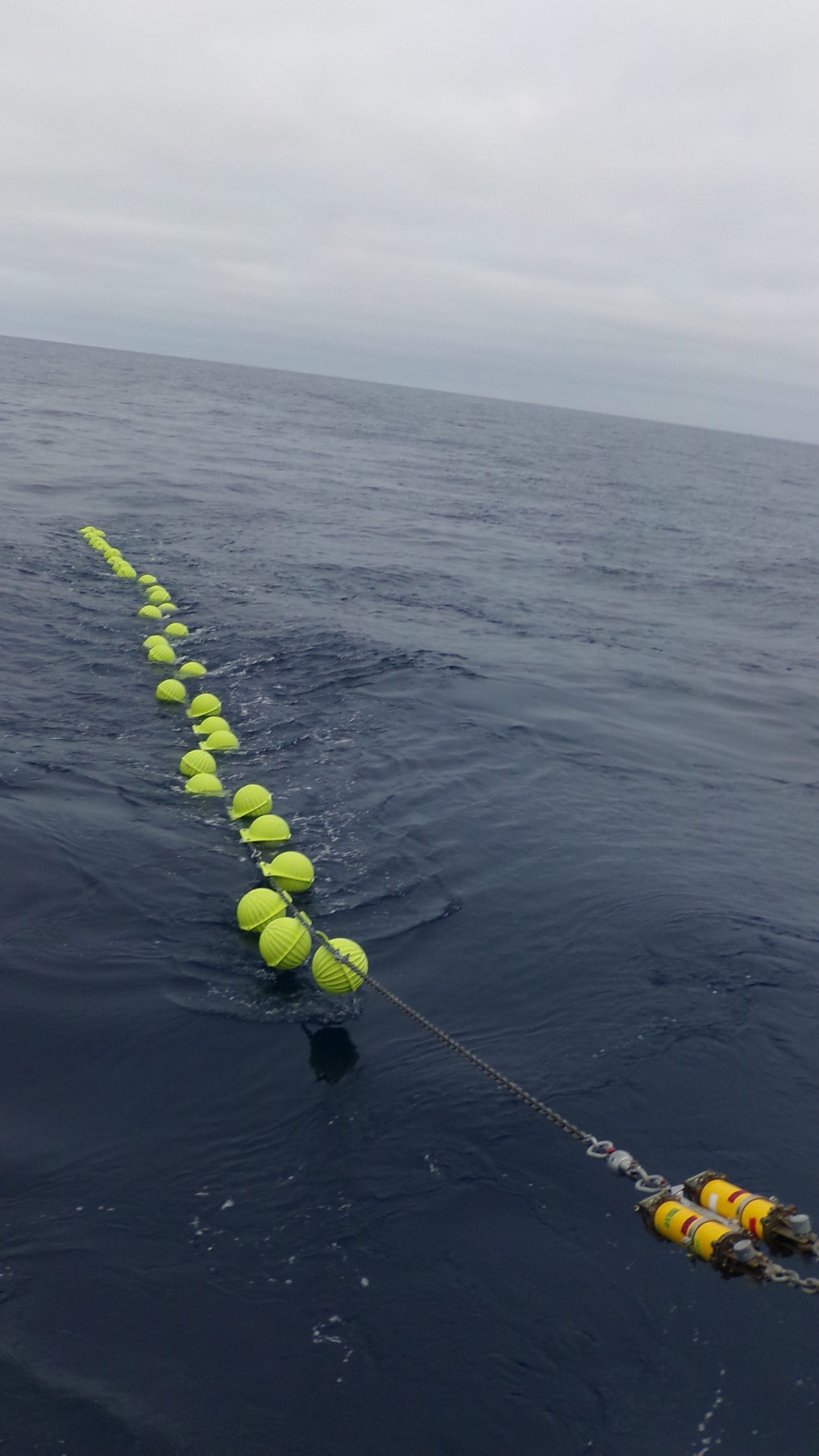
[embed]http://https://vimeo.com/585980063[/embed] [media-caption path="http://https://vimeo.com/585980063" link="#"]Shown above is the recovery of a Global Station Papa Array subsurface mooring by the team aboard the R/V Sikuliaq. The mooring was coated with marine life that had been growing there for the past two years. The team cleaned the mooring as the ship transited to its next station. Video courtesy of Bern McKiernan. [/media-caption]The periodic turning of the moorings present opportunities to incorporate design innovations into the arrays. The new moorings have improved controllers and new positioning beacons with GPS and flashers built into the housing, which will help increase performance and simplify recovery.
The team returned to Seward on August 2, then made their way back to their home port in Woods Hole, MA. The data retrieved from the moorings will help researchers investigate topics related to climate, ocean circulation, biological productivity, and ocean acidification in this important region of the Northeast Pacific.
Read More
CGSN Webinar 15 September
An informational webinar on the OOI Coastal and Global Scale Nodes (CGSN) will be presented on 15 September 2021 from 3:00-4:00 pm EDT. A presentation by the CGSN Team will be followed by a Q&A session.
Topics covered will include infrastructure making up the CGSN Arrays (Coastal Pioneer, Global Irminger Sea, and Global Station Papa), the current status of deployments, how to access near real-time data, and how to engage with the OOI.
Register here so you don’t miss out on the opportunity to meet the OOI CGSN Team and learn how you can work together.
Read More
Summer at Sea: Three Arrays Turned
This summer has been a busy time for OOI’s teams, who are actively engaged in ensuring that OOI’s arrays continue to provide data 24/7. Teams are turning – recovering and deploying – three arrays during July and August. The first expedition occurred earlier in July when a scientific and engineering team spent 16 days in the Northeast Pacific recovering and deploying ocean observing equipment at the Global Station Papa Array. The team recovered three subsurface moorings and deployed three new ones. They also deployed one open ocean glider, recovered one profiling glider, and conducted 11 CTD casts (which measure conductivity, temperature, and depth) to calibrate and validate the instruments on the array. After completing this eighth turn of the Station Papa Array, the team returned to Woods Hole Oceanographic Institution by way of Seward, Alaska on the second of August.
[embed]https://vimeo.com/580883575[/embed]On 30 July, the Regional Cabled Array team embarked on the first of four legs of its 37-day Operations and Maintenance Cruise aboard the R/V Thomas G. Thompson. The ship, operated by the University of Washington, is hosting the remotely operated vehicle (ROV) Jason, operated by Woods Hole Oceanographic Institution (WHOI). During the cruise, Jason will be used to deploy and recover a diverse array of more than 200 instruments from the active Pacific seafloor. The science, engineering, and ROV teams will be joined this year by 19 students sailing as part of the University of Washington’s educational mission (VISIONS’21). A live video feed of the ship’s operations and Jason dives is available for the duration of the cruises.
[media-caption path="https://oceanobservatories.org/wp-content/uploads/2021/07/r1472_elguapo.top_.web_-768x511-1.jpg" link="#"]The Regional Cabled Array team expects to share imagery as spectacular as this during its upcoming cruise. Shown here is the El Guapo hot spring, covered in life venting boiling fluids 4500 feet beneath the oceans surface. Credit: UW/NSF-OOI/CSSF; V11.[/media-caption]On 3 August, a team from WHOI boarded the R/V Armstrong for a weeklong transit to recover and deploy the Global Irminger Sea Array, off the Southeast coast of Greenland. The array is located in one of the most important ocean regions in the northern hemisphere and provides data for scientists to better understand ocean convection and circulation, which have significant climate implications. A science and engineering team will be deploying and recovering a global surface mooring, a global hybrid profiler mooring, two global flanking moorings, and three gliders (two open ocean and one profiling) during the three-week expedition. The team will also carry out shipboard sampling and CTD casts to support the calibration and validation of platform sensors while underway. A novel aspect of this cruise is that near real-time CTD profiles will be made publicly available during the cruise. The profiles will be evaluated by onshore staff, who will provide feedback to the ship, and share online assessment of CTD results.
“This summer’s at-sea activities are the culmination of months of planning, testing, and logistical work that goes on behind the scenes to make these expeditions possible,” said John Trowbridge, OOI’s Principal Investigator and head of the Program Management Office. “A tremendous amount of human effort and ingenuity is required to keep the arrays operational year-round, particularly in some of the ocean’s most challenging environments like the Irminger Sea and on the seafloor at Axial Seamount. The data collected, however, are essential, providing scientists with the tools needed to understand our changing ocean.”
The progress of the expeditions will be reported on these pages and on OOI’s social media channels.
[media-caption path="https://oceanobservatories.org/wp-content/uploads/2021/07/Irminger-Surface-mooring-.jpg" link="#"]A global surface mooring in the Woods Hole Oceanographic Institution stage area is outfitted and ready for deployment in the Irminger Sea Array. Photo: ©Jade Lin, WHOI[/media-caption]
Read More
Eighth Turn of Station Papa Array Set for July
After 20 months in the water, the Global Station Papa Array will be turned (old moorings recovered and new ones deployed) in July for the eighth time. Normally, this array is turned every year, but last year the trip was cancelled due to constraints imposed by the COVID-19 pandemic. In early July, the OOI team will head to Seward, Alaska to begin preparations for this long-due operation.
The OOI team will arrive in Seward and load the R/V Sikuliaq with over 54 tons of equipment. Following one week of equipment mobilization and build, and a precautionary seven-day COVID isolation period, the team will depart for a 16-day cruise in the Northeast Pacific. The team will recover three Station Papa subsurface moorings and deploy three new ones. Along the way, they will also deploy two Open Ocean Gliders, recover one Profiling Glider, and conduct 11 CTD casts, which will help calibrate and validate the instruments on the array. The design of the moorings and gliders, as well as their planned locations, can be found here.
The robust array was designed for a 12-month deployment between turns, but due to COVID this interval had to be extended to 20 months. The extended duration may have affected data quality since bio-fouling on instruments accumulates over time. However, past experience with extended durations has been positive such that the team’s expectations regarding data quality is high.
“Regular maintenance is vital for keeping the arrays working and collecting data, so this cruise is an especially important one,” said Chief Scientist Kris Newhall, who leads the seven members of the Station Papa 8 team.
The moorings have several design updates, including improved controllers and new positioning beacons with GPS and flashers built into the housing. The upgrades will increase the performance of the moorings and simplify recovery operations.
The Global Station Papa Array is an important part of the OOI network, and the data it has collected is helping to shed light on the physical and biological dynamics for this region of the North Pacific.
Read More