
Posts Tagged ‘MAB’
Successful Underwater Surveys in the Mid-Atlantic Bight: OOI Team Deploys REMUS AUVs for Coastal Ocean Monitoring
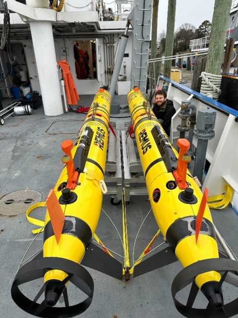
Taking advantage of a period of calm weather, OOI staff successfully completed underwater surveys of the Pioneer Mid-Atlantic Bight (MAB) shelf and upper slope using OOI REMUS AUVs. With ab underway speed of over 3 knots, the AUVs provide synoptic transects of rapidly changing coastal systems – analogous to repeated “snapshots” of the ocean physical, biological, and nutrient conditions across the shelf capturing changes that occur over short time and spatial scales (meters to kilometers, and hours to one day).
The OOI Pioneer array was relocated from the New England Shelf (NES) to the southern Mid-Atlantic Bight in April 2024. AUV surveys previously conducted in the continental shelf waters offshore of New England now take place offshore of the sandy Outer Banks of North Carolina in a new and highly dynamic part of the US continental shelf. Moving the Pioneer Array to the MAB naturally resulted in some changes to operations, foremost being the use of new vessels (for this cruise, the R/V Virginia operated by the Virginia Institute of Marine Science). For efficiency, the AUVs are shipped fully assembled inside a 20 ft shipping container, along with all communications, control, and deck equipment. On arrival everything can be hoisted aboard and prepared for sea without needing re-integration that consumes valuable days on shore (Fig 1). The ships crane was modified by WHOI engineer Jared Schwartz to install the Ship of Opportunity Launch and Recovery System (SOO-LARS), a modular hydraulic winch system that OOI employs for safe and efficient deployment and recovery of these large AUVs on ships of several classes (Fig. 2).
The AUV operations at MAB derive from previous work at Pioneer NES. Once deployed, the AUVs run autonomously and sample in a series of saw-tooth profiles along a pre-programmed track, remaining in acoustic contact with the support vessel and surfacing periodically to update exact location from GPS. These plans were adapted for the MAB to compensate for the larger expanse of shelf traversed and the large changes in water column density between the shallow (25 m) inner shelf and deeper > 500 m upper slope. This is further complicated by density variations along the shelf and seasonally under the triple-influence of estuarine outflows, continental shelf processes, and the Gulf Stream just a few miles beyond the offshore extent of the sampling region (Fig 3). The MAB is also busy with a range of commercial, fishing, and military vessel traffic, offshore fixed installations, and ocean life in every shape and size imaginable. All factors that must be considered in advance and avoided underway by the invisible submerged AUVs. As was true for Pioneer NES, the support and knowledge of local vessel operators is vital to supporting at-sea operations and for meeting OOI’s science mission objectives.
The AUV data were offloaded from the vehicles after recovery. The data are discoverable in the OOI Data Explorer, and also available on the OOI raw data repository, following data format conversion and sensor post-calibration.
In addition to completing two consecutive surveys, each about 24 hours in length, the at-sea team of Andy Robinson, Collin Dobson, and Natalia Moore completed the scheduled recovery of the Offshore Mesoscale glider cp_379 (Fig. 4). A bonus accomplishment of this cruise was cross-training OOI staff new to AUV operations (Moore), made easier by the prevailing mild weather, experienced AUV techs, and the capable ship’s crew.
[gallery columns="2" size="large" ids="35942,35943,35944,35945"]Photo credits: Collin Dobson
Read MoreOpportunity to Add New Sensors/Equipment to Pioneer MAB Array
The U.S National Science Foundation (NSF) Ocean Observatories Initiative (OOI) is excited to report that the relocation of the Pioneer Array to the Mid-Atlantic Bight (MAB) is now complete and the OOI facility is again considering requests by Principal Investigators to add new sensors and/or equipment to the Pioneer MAB Array. The process for requesting additions to the Array is described here.
The MAB deployment is the culmination of a three-year, multi-tiered process to relocate the Pioneer Array from its former location off the New England Shelf to the MAB. The NSF and the OOI Facilities Board (OOIFB) hosted a series of workshops in 2021 to elicit community input on where a relocated Pioneer Array might best meet science and educational needs. Based on input from these community workshops, the NSF gave its approval to the MAB site and the process was launched. Data from most instruments is available in real-time from the OOI Data Explorer. All non-telemetered data will be available after instruments are recovered on Array maintenance cruises that occur at nominal six-month intervals (April, October).
“Completing installation of the Pioneer Array in the MAB was the culmination of a significant effort by the OOI Team,” said Al Plueddemann, who served as the Chief Scientist for the first deployment of the array in the MAB and is Principal Investigator for OOI’s Coastal and Global Scale Nodes. “The time is right for researchers to propose additional sensors or equipment be added to the array so its full data collection potential can be realized.”
Notes:
- The installation of some sensors, especially acoustic sensors, may be subject to compliance with NSF’s Memorandum of Understanding with the US Navy.
- While the requests must be made for any additions to the Array, OOI would appreciate notification on plans to deploy stand-alone instrumentation within the OOI footprint.
 Pioneer MAB Layout[/caption]
Read More
Pioneer MAB Layout[/caption]
Read More Pioneer Array Operational at MAB
A move is declared
Months of toil undertaken
This day it is done
Coastal and Global Scale Nodes (CGSN) Principal Investigator Al Plueddemann penned the haiku above in recognition of the successful installation of the Pioneer array at its new location in the Mid-Atlantic Bight (MAB) on April 17, 2024. This momentous occasion occurred on Haiku Wednesday, which prompted the poetic marking of a three-year effort to have the array deployed and telemetering data from the MAB.
The relocation of the Pioneer Array from its former location off the New England Shelf (NES) to its new location was a multi-tiered process. The National Science Foundation (NSF) joined forces with the Ocean Observatories Initiative Facility Board (OOFIB) to host a series of workshops in 2021 to elicit community input on where a relocated Pioneer Array might best meet science and educational needs. Based on input from these community workshops, the NSF gave its approval to the MAB site and the process was launched.
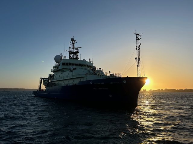
“Completing installation of the Pioneer Array in the MAB was the culmination of three years of preparation, which began with planning workshops in 2021, the recovery of the NES array in 2022, and engineering, procurement, and testing in 2023,” said Plueddemann, who also served as the Chief Scientist aboard the R/V Neil Armstrong for the first deployment of the array in the MAB. “It took an incredible effort from the whole CGSN Team to address all the considerations in moving the array to its new location. It is gratifying to see the successful deployment, with new, multidisciplinary data now available from this important oceanic region.”
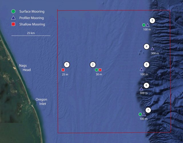
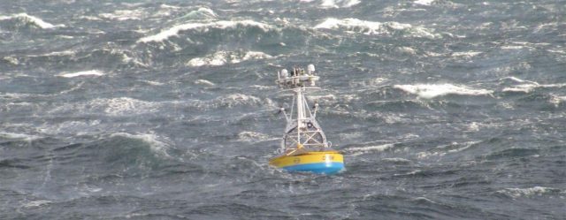
[media-caption path="https://oceanobservatories.org/wp-content/uploads/2024/04/New-shallw.jpg" link="#"]Two newly designed shallow water moorings were deployed at the Pioneer MAB site. These specially designed moorings allow a wave-powered profiler to span the upper 80% of the water column in water depths as shallow as 25-30 m. Credit: Sawyer Newman © WHOI.[/media-caption]The primary objectives for the April cruise included installation of three surface moorings, five profiler moorings, and two newly designed shallow water moorings. The moorings create the backbone of MAB Array, a frontal-scale, T-shaped array located off the coast of Nags Head, North Carolina, starting ~25 km offshore and extending ~50 km east/west and ~50 km north/south across the continental shelf. The ten moorings occupy seven sites; three sites contain both a surface mooring and a profiler mooring. In order to provide synoptic, multi-scale observations of the outer shelf, shelf break, and continental slope, the moored array is supplemented by four gliders and two AUVs. The gliders operate for 45-90 days at a time, provide transects along and across the shelf, and monitor the mesoscale field of the slope sea. The AUVs are deployed and recovered from the ship over a ~24 hr period and provide synoptic across- and along-front “snap shots” of the frontal region.
[media-caption path="https://oceanobservatories.org/wp-content/uploads/2024/04/NESLETER.png" link="#"]Collaboration between OOI and the Northeast U.S. Shelf (NES) Long-Term Ecological Research (LTER) project began in 2017 and continued during this deployment expedition.Taylor Crockford was onboard to deploy an Imaging FlowCytobot (IFCB) that continuously sampled seawater while the Armstrong was underway. Shown here are some of the creatures living in the seawater along the route. Credit: Taylor Crockford © WHOI.[/media-caption]Once the deployment was in place, the team turned its attention to additional expedition objectives, including a bathymetry/sub-bottom survey of a potential alternate Western mooring site, and cross-shelf and along-shelf CTD (conductivity, temperature, and depth) transects. Once those were completed, the team headed home aboard the R/V Neil Armstrong to its home port in Woods Hole, MA where they were heartily greeted for a job well done.
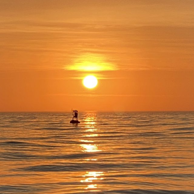
[media-caption path="https://oceanobservatories.org/wp-content/uploads/2024/04/Sunrise-17-April-Ryder-2-scaled.jpg" link="#"]The sunrise was captured on 17 April over the Northern Offshore Surface buoy, highlighting the completion of the installation of the Pioneer Array in its new location in the Mid-Atlantic Bight. Credit: Jim Ryder © WHOI.[/media-caption]A review of the day-to-day operations to install the Pioneer Array in the Mid-Atlantic Bight m can be found here.
Read MoreAnd It’s a Wrap!
The Coastal Pioneer Array MAB team completed all the objectives of Leg 1 by the end of the day April 8th and started the transit home, back to the dock at Woods Hole. Taking advantage of a day in the wet lab, Glider Lead Diana Wickman took the opportunity to interview some folks about their experiences aboard the Armstrong over the last nine days. Hear what they have to say about the best parts of the journey.
Read MoreHoses Galore Hold Moorings Together
A flexible connection between the buoy and the anchor of the Coastal Surface Moorings of the Pioneer MAB Array is created by multiple hoses with the capacity to stretch while maintaining an electrical connection (Fig 1). The stretch is necessary to account for wind, waves and currents that push and pull the buoy relative to the anchor. The hoses connect mooring components and contain coiled conductors that allow data transfer and carry power generated by wind turbines and solar panels on the buoy.
The Northern Coastal Surface Mooring deployed for the first time in the MAB on April 4, 2024, illustrates the vital role these connection points play in keeping the mooring in place and operating. The mooring was deployed in 100 meters of water. The surface buoy is connected to the near surface instrument frame with a five-meter-long electromechanical chain (EM) chain. The EM Chain is flexible enough to bend to allow deployment (Fig. 2) but does not stretch. This provides support and stability at the top of the mooring. The EM chain also contains conductors to allow transmission of power created by solar, wind, and batteries on the surface mooring to the instruments below.
[media-caption path="https://oceanobservatories.org/wp-content/uploads/2024/04/EMChain.jpg" link="#"]Fig 2. The EM Chain connects the bottom of the surface buoy to the Near Surface Instrument Frame (NSIF) to left. Credit: DT Crist © WHOI.[/media-caption]Power moves through the EM chain to the instruments attached to the Near Surface Instrument Frame (NSIF), and then off to three stretch hoses each 30.48 meters long! The stretch hoses do what their name implies, stretch as needed in response to environmental conditions, yet they are strong enough to keep the mooring in place. The first section of stretch hose is connected to a Hose Interface Buoyancy (HIB) module, an orange flotation device that helps keep the stretch hoses floating and upright. The second section of stretch hose connects to a second HIB. Electrical connectivity is maintained by wired connections from the end of a stretch hose, through the hollow center of the HIB, and then to the next hose.
[media-caption path="https://oceanobservatories.org/wp-content/uploads/2024/04/HIBS.jpg" link="#"]Two Hose Interface Buoyancy (HIBs) sections are connected to each other with electromechanical stretch houses that provide flexibility and strength to the mooring and transmit power down the line. Credit: DT Crist © WHOI.[/media-caption]The third stretch hose section is connected to the Multi-Function Node (MFN), which houses instruments that need power. The MFN also contains the anchor.
[media-caption path="https://oceanobservatories.org/wp-content/uploads/2024/04/MFN.png" link="#"]The Multi-Function Node and Anchor Assembly being deployed off the back deck of the R/V Neil Armstrong. The stretch hose, which connects it to the rest of the mooring, is at the top and to the right. Credit: DT Crist © WHOI.[/media-caption]
[media-caption path="https://oceanobservatories.org/wp-content/uploads/2024/04/Complete-configuration.jpg" link="#"]More than 96 meters of hose keep the Coastal Pioneer Northern Array in place in its new location in the Mid-Atlantic Bight. Credit: DT Crist © WHOI.[/media-caption]
Perspective in Pounds
What’s amazing about the hoses that keep the Pioneer moorings on station and operational is the scale of the equipment that makes up the mooring. Take the top and the bottom of the mooring, for example. The Surface Buoy weighs some 8,500 pounds. The MFN and Anchor Assembly weigh 11,000 pounds. These weights and the scale of the equipment are not only challenging for moving around the deck and getting into the water, but thanks to the hoses these massive components are able to stay in the water, collect data, and report for up to six months. Hats off to hoses galore!
Read More
Instrumentation Updates for Planned Pioneer MAB Array
Community Input
The Ocean Observatories Initiative Facilities Board (OOIFB), sponsored by the National Science Foundation (NSF) and in partnership with KnowInnovations, facilitated two community workshops, called Innovations Labs, that resulted in the decision to relocate the Pioneer Array to the southern Mid-Atlantic Bight (MAB). The second Lab included community input on measurements that would be desirable for the relocated array. More than 40 instruments or measurement types were discussed. This was reduced to about a dozen high-priority recommendations based on consensus among the Innovations Lab sub-groups. After considering applicability to the science themes, technical readiness level, operational feasibility, and budget impacts the OOI Program was able to implement the majority of the high-priority recommendations.
Among the goals for the relocation process was to optimize the use of existing inventory, and it was possible to do so while addressing several of the instrumentation recommendations. In some cases, new procurements were required, although it should be noted that one of these procurements was needed to replace an obsolete core sensor. A summary of the instrumentation updates for the proposed Pioneer MAB relocation in these two categories is provided below.
Repurposing of Existing Core Instruments
The OOI deploys a set of core instruments across all the Arrays. Reconfiguration of the Pioneer Array elements, along with some inventory available from the decommissioned southern hemisphere arrays, meant that some instrumentation could be repurposed for the Pioneer MAB Array without requiring new purchases. Five instrumentation changes were made using this approach:
- Near-surface temperature and salinity: A Seabird SBE-37 CTD will be mounted on the “foot” of the five Coastal Profiler Mooring (CPM) buoys.
- Incident radiation: A Sea Bird OCR-507 multispectral radiometer will be mounted on the tower of the three Coastal Surface Mooring (CSM) buoys. This instrument will measure downwelling radiation per unit area.
- Surface wave spectra: A TriAxys Next Wave sensor will be added to the buoy well of all three CSMs. These sensors, which provide both non-directional and directional wave parameters, were previously deployed on only the Central CSM for the Pioneer NES.
- Turbidity: Seabird ECO triplet instruments with a secondary turbidity calibration on the optical backscatter channel will be deployed on the Near Surface Instrument Frame (NSIF) and seafloor Multi-Function Node (MFN) of the three CSMs.
- Nitrate: A glider with a Sea-Bird SUNA nitrate sensor will be deployed on the offshore “flux line”.
New Procurements
Several of the high-priority recommendations from the Innovations Labs that were deemed feasible for implementation required instrumentation that was not part of the OOI core. In this case, a formal procurement process is required (the process for replacing an obsolete sensor is similar). Four measurements required new instrument procurements: Near-surface velocity, phytoplankton imagery, particle size, and seafloor pressure. The procurement process for these instruments was initiated in November 2022.
The procurement process involves multiple steps of specification, information collection, review and approval before actual purchases are made. Among the first set of steps executed for the Pioneer MAB procurements were: consultation with a Focus Group of scientists external to the OOI, development of measurement specifications and revision of requirements as needed. The specifications were then used to create a solicitation of information from vendors through a broadly disseminated Request For Information (RFI). The RFI responses were reviewed by a selection committee composed of both internal and external subject matter experts, who evaluated instrument and vendor capabilities relative to performance specifications, technical feasibility, cost, and other factors. Additional steps included Design Reviews and Selection Reviews where the documentation of the process is presented to the Program Management Office and the NSF. After approval of vendor selection from the Review steps, orders were placed for the new equipment.
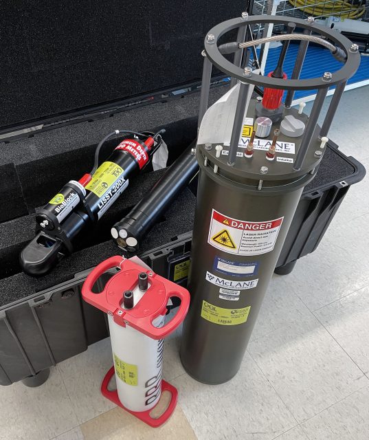
The Program is currently pursuing the procurement of four instrument classes, with 15 instances to be deployed at different locations within the Pioneer MAB Array (Table 1). Instrument locations include the buoy, Nearshore Instrument Frame (NSIF) and Multi-Function Node (MFN) on the Coastal Surface Moorings, and the buoy and buoyancy sphere of the Coastal Profiler Moorings.
Table 1: New Instrument Procurements for Pioneer MAB
| Measurement | OOI Code | Make/Model | Location | Instances |
| Near-surface velocity profile | ADCPU | Nortek Aquadopp profiler 1MHz | Coastal Profiler Mooring Sphere | 5 |
| Plankton Imaging | PLIMS | McLane Imaging Flow CytoBot | Coastal Surface Mooring Central site NSIF | 1 |
| Particle Size Analysis | PRTSZ | Sequoia LISST-200X | Coastal Surface Mooring NSIF and MFN | 6 |
| Seafloor Pressure | PRESF | RBR Quartz3Qplus | Coastal Surface Mooring MFN | 3 |
More information on the proposed relocation of the Pioneer Array to the Mid-Atlantic Bight is available here.
Read More
Another Round of Pioneer MAB At-Sea Tests Completed
A team of OOI Coastal and Global Scale Nodes (CGSN) scientists and engineers returned to Woods Hole, MA aboard the R/V Neil Armstrong on November 4, having successfully completed another round of tests of mooring equipment and site location surveys for the proposed relocation of the Coastal Pioneer Array to the Mid-Atlantic Bight (MAB), off the coast of Cape Hatteras, NC.
[media-caption path="https://oceanobservatories.org/wp-content/uploads/2023/11/IMG_6640-2048x2048-2.jpg" link="#"]The OOI-CGSN team surveyed the seabed to better understand the environment for the proposed moorings sites. The RV Neil Armstrong operated hull-mounted acoustic equipment to collect bathymetry (depth contours; shown left ), backscatter imagery (seabed characterization), and sub bottom data (seabed profile and geophysical layering). Chris Basque and Irene Duran (shown right) also piloted the ROV over the mooring locations to collect still images, video, and high-resolution sonar of the seabed. Photos: Sheri N. White © WHOI.[/media-caption] [media-caption path="https://oceanobservatories.org/wp-content/uploads/2023/11/IMG_6643-1536x1536-1.jpg" link="#"]Closeup of multi-beam survey.[/media-caption]Having accomplished all of the primary cruise objectives under un-seasonally warm and calm conditions, the weather picked up at the MAB as they were finishing up the last two CTD (Conductivity, Temperature, and Depth) surveys along the proposed location of the main mooring lines.
The team then headed north to conduct a final ROV survey of the Shallow Water test mooring they had put in place the week before in 32 meters of water southwest of Martha’s Vineyard. This ROV inspection was the second conducted at this mooring location. A first inspection was done shortly after the mooring’s deployment, when all components were found to be in place and operational. The second confirmed the earlier findings.
In addition to deployment of the Shallow Water test mooring off Martha’s Vineyard, the CGSN team conducted recovery operations onsite at MAB. They recovered the Coastal Profiler Mooring anchor, deployed in the spring of 2023. The mooring itself had been recovered in August of this year. The team also recovered the Coastal Surface Mooring after ~8 months operating at the proposed Pioneer MAB location. The mooring was deployed in a water depth of 30 m and survived storms with max wave heights of 7.5-10 m and continued to send data to shore!
[media-caption path="https://oceanobservatories.org/wp-content/uploads/2023/11/IMG_6642-1536x1536-1.jpg" link="#"]The Coastal Surface Mooring is safely on deck after ~8 months operating at the proposed Pioneer Mid-Atlantic Bight location. Credit: Sheri N. White © WHOI.[/media-caption]Other activities conducted during the 11-day expedition included a site surveys (utilizing multi-beam, sub-bottom, and ROV) of alternate mooring locations, and cross-shelf and along-shelf CTD surveys to better understand the oceanographic conditions in the Mid-Atlantic Bight.
“Conducting at-sea tests of our infrastructure and detailed environmental surveys of the environment are important to ensure the success of new OOI Array,” said Sheri N. White, Chief Scientist for the recovery cruise. “We were lucky to have excellent weather for our deployment and recovery cruises. But also pleased that our test moorings experienced challenging weather during the deployment. This gives us the confidence that the moorings can operate successfully in the new environment and collect data year-round.” The plan is to deploy the Coastal Pioneer Array in its new location in spring 2024.
More details about and images from the expedition can be found here.
Read MorePBS of North Carolina Blogs about Pioneer’s New Location
In a blog post, the PBS of North Carolina summarizes plans for the relocation of the Coastal Pioneer Array to a site of the coast of Carolina:
[media-caption path="https://oceanobservatories.org/wp-content/uploads/2023/10/PBS-Blog.jpeg" link="#"]Surface moorings of the Pioneer Array loaded with scientific instruments are built to withstand all types of ocean conditions. ©WHOI.[/media-caption]Water covers about 71% of the Earth’s surface, and our oceans hold about 96.5% of it. It’s no surprise then that oceans play a key role in the Earth’s weather, climate and food supply.
So, it’s important to know what’s happening in the ocean. And the ocean off North Carolina’s coast is going to get a closer look starting in 2024. That’s when a set of scientific instruments, called the Coastal Pioneer Array, will be deployed about 35 miles off Nags Head. The system is part of the Ocean Observatories Initiative, or OOI.
“The OOI offers many opportunities for scientists to obtain data to further their research, and it provides insight into conditions in the area for a variety of stakeholders,” said Dr. Albert Plueddemann, project scientist for OOI’s Coastal Global Scale Nodes group at Woods Hole Oceanographic Institution. “We welcome researchers, educators and industry members to reach out to us to explore ways we might work together to maximize the usefulness of the data.”
Read the entire post here.
Read More
Pioneer Mid-Atlantic Bight At-Sea Tests Continue
On Monday October 23, 2023, a team of scientists and engineers from Woods Hole Oceanographic Institution (WHOI) left Woods Hole, MA aboard the R/V Neil Armstrong to conduct a variety of at-sea tests to continue preparations for the anticipated move of the Coastal Pioneer Array to the Mid-Atlantic Bight (MAB), off Cape Hatteras, NC. The science team first traveled to a site off the coast of Martha’s Vineyard to deploy a newly designed shallow water mooring (SWM). This test deployment site was chosen because it offers suitable conditions to test the moorings performance in a shallow water environment, with easy access from Woods Hole, simplifying monitoring and recovery.
The mooring will be deployed for a few months to test the seabed multifunction node, buoyant stretch hose, riser cable, and Prawler profiling vehicle. Engineering data will be collected and assessed prior to the SWM’s deployment at the proposed Pioneer Mid-Atlantic Bight in Spring 2024.
[media-caption path="https://oceanobservatories.org/wp-content/uploads/2023/10/Pioneer-MAB-schematic.png" link="#"]Schematic drawing of the proposed Pioneer MAB moored array to be deployed off the coast of Nags Head, North Carolina. The full array, proposed to be deployed in the spring of 2024, would consist of ten moorings at seven different sites (three sites contain mooring pairs). For the test deployment, one Coastal Surface Mooring was deployed at the Central site and one Coastal Profiler Mooring was deployed at the Northeast site.[/media-caption]From there, the team will head to the Mid-Atlantic Bight to recover a mooring and two anchors that have been in place since spring 2023. Other activities will include a multibeam and sub-bottom site survey and ROV inspection of alternate sites. Water and CTD sampling will be conducted at various depths at the proposed mooring locations. Ancillary science activities will be conducted as time allows. The public comment period on the environmental assessment of the new location is open until October 30, 2023.
“The goal of our test cruises is to evaluate our mooring designs and instrument sampling strategies, and collect environmental data at the new location. This will help to ensure a successful first deployment in the spring of 2004,” said Sheri N. White, Chief Scientist for this expedition and a senior engineer at WHOI. “Understanding the seafloor and water column conditions in the Mid-Atlantic Bight will help us to confirm the optimum locations for the moorings and paths for the gliders and AUVs.”
“This new location in the MAB offers many opportunities for scientists to obtain data to further their research and will provide better insight into conditions in the area for a variety of stakeholders, “said Al Plueddemann, Project Scientist for OOI’s Coastal and Global Scale Nodes group at WHOI, which is responsible for operation of the Pioneer Array. “We welcome researchers, educators, and industry members to reach out to us to explore ways we might work together to maximize the usefulness of the data.”
The new MAB site offers opportunities to collect data on a variety of cross-disciplinary science topics, including cross-shelf exchange and Gulf Stream influences, land-sea interactions associated with large estuarine systems, a highly productive ecosystem with major fisheries, processes driving biogeochemical cycling and transport, and fresh-water outflows during extreme rain events.
The test mooring data will be evaluated during the deployment and after recovery to determine whether any modifications are needed to the mooring designs. The full array will be deployed at the new Mid-Atlantic Bight location in the spring 2024. The At-Sea Test expedition team is expected to return to Woods Hole in early November.
Read More
OOI Engineers Develop New Rechargeable Lithium-ion Battery Pack
By John Lund, Research Associate, Woods Hole Oceanographic Institution
The final deployment of the Coastal Pioneer Offshore Mooring (CP04OSPM-00016) was the first deployment of a prototype rechargeable lithium-ion battery pack. The deployment was a success with the battery pack providing power throughout the entire 6.5-month deployment.
Working with Mathews Associates Inc. the OOI engineering team developed a drop-in replacement lithium-ion rechargeable battery pack to replace the original one-time use alkaline packs. Each alkaline pack consists of 72 D-sized batteries that are fabricated into a hexagonal assembly. Nine of these battery packs are fitted into a buoy battery chassis that fits inside the buoy well. The packs are wired together in parallel to provide the required voltage to power the computer (buoy controller) responsible for telemetry and data-logging.
Pioneer moorings are nominally deployed for 6-month intervals. Variability in ship scheduling requires that the buoys be capable of operating for 7+ months. The alkaline battery chassis was designed to fit enough packs to power the buoy for the planned duration and or until the recovery ship arrived.
[media-caption path="https://oceanobservatories.org/wp-content/uploads/2023/08/Lithium-batteries.jpg" link="#"]Lithium Battery chassis during testing and integration with the buoy computer. Battery chassis is on the left. Buoy end cap with Linux computer board on the bench. Wire Following Profiler center on the floor collects the majority of the Profiler Mooring data set.[/media-caption]The Offshore mooring was selected to be a test mooring because it is one of the deeper moorings in the New England Shelf (NES) Pioneer Array and as such logs and transmits more data than a shallower mooring. The larger data sets mean that the buoy up-time, and therefore power usage, is greater than one in shallower water so this would be a tougher test of the lithium-ion packs.
Although there is an increased cost to purchasing the initial set of lithium batteries there are many advantages to the rechargeable batteries. Because the alkaline packs are conservatively sized for the deployment there is often a considerable amount of power remaining in the packs when they are recovered, yet this remaining power is insufficient for another full deployment, and new batteries must be used. The chief benefit of the rechargeable batteries will be to keep the one-time use alkaline packs from going to the landfill (~1 ton per year). There is also a considerable labor savings of not having to deconstruct and reload the chassis frames with replacement batteries. Our calculations indicate that we will break in terms of procurement cost compared to alkaline batteries in approximately six years and that the lithium-ion batteries have enough charge cycles (500) to last the duration of the program. With any luck these may be the last batteries we need to purchase for the Profiler Moorings!
Read More