
Posts Tagged ‘National Science Foundation’
Open Access, Open Ocean: Marking 75 Years of NSF Through Sustained Ocean Observation
This week, the OOI joins the scientific community in celebrating the 75th anniversary of the U.S. National Science Foundation (NSF). This milestone marks decades of national investment in science, innovation, and public benefit.
OOI exists because of NSF’s vision and support. Our mission, delivering long-term, openly accessible ocean data, reflects a shared commitment to expanding scientific knowledge and ensuring that access to that knowledge is equitable, inclusive, and available to all.
Open Access Data: A Shared Commitment
The NSF’s mission is rooted in the belief that the progress of science should benefit all and be free from barriers to participation. OOI carries this forward through its core function: providing open access to high-resolution oceanographic data collected from some of the most remote and dynamic regions of the ocean.
OOI’s infrastructure, which spans cabled, coastal, and global sites, captures continuous, multi-dimensional data on key ocean processes. This data, ranging from temperature and salinity to seafloor seismic activity, is made freely available in near real time to anyone: scientists, educators, students, and the public.
For both OOI and NSF, access to data isn’t just a technical feature, it’s a fundamental value. Transparency, inclusivity, and public benefit are central to how we operate.
Investing in Infrastructure
NSF invests in strengthening the nation’s ability to conduct research and turn scientific insights into benefits for society. OOI supports this by maintaining a robust, continuously operating network of ocean sensors and platforms. This infrastructure enables:
- Collaborative research across institutions and disciplines
- Technology testing and innovation in extreme marine environments
- Educational engagement using real-world datasets
- Data-driven decision-making on ocean and climate issues
OOI’s open access model makes it possible for anyone, from seasoned scientists to high school students, to use ocean data to ask questions and find answers.
A Model for Public Science
In a time when access to credible, timely data is more important than ever, OOI’s approach serves as a model for how federally funded science can empower public knowledge and innovation. By making data easier to access and use, we help to ensure that science reaches more people and that the benefits of NSF-funded research are shared more broadly.
Looking Ahead: Sustaining Discovery
As the NSF celebrates 75 years, we acknowledge its enduring contributions to scientific advancement and public understanding. Its support for open, collaborative research continues to play a crucial role in driving discovery and responding to the evolving questions shaping science today.
With the continued support of the NSF, OOI is honored to play a role in this shared mission. We remain committed to advancing ocean science, making ocean data widely accessible, and deepening understanding of the ocean’s impact on our planet.
Read More
Opportunity to Add New Sensors/Equipment to Pioneer MAB Array
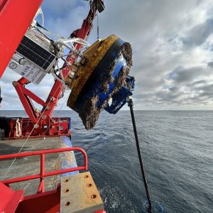
The U.S National Science Foundation (NSF) Ocean Observatories Initiative (OOI) is excited to report that the relocation of the Pioneer Array to the Mid-Atlantic Bight (MAB) is now complete and the OOI facility is again considering requests by Principal Investigators to add new sensors and/or equipment to the Pioneer MAB Array. The process for requesting additions to the Array is described here.
The MAB deployment is the culmination of a three-year, multi-tiered process to relocate the Pioneer Array from its former location off the New England Shelf to the MAB. The NSF and the OOI Facilities Board (OOIFB) hosted a series of workshops in 2021 to elicit community input on where a relocated Pioneer Array might best meet science and educational needs. Based on input from these community workshops, the NSF gave its approval to the MAB site and the process was launched. Data from most instruments is available in real-time from the OOI Data Explorer. All non-telemetered data will be available after instruments are recovered on Array maintenance cruises that occur at nominal six-month intervals (April, October).
“Completing installation of the Pioneer Array in the MAB was the culmination of a significant effort by the OOI Team,” said Al Plueddemann, who served as the Chief Scientist for the first deployment of the array in the MAB and is Principal Investigator for OOI’s Coastal and Global Scale Nodes. “The time is right for researchers to propose additional sensors or equipment be added to the array so its full data collection potential can be realized.”
Notes:
- The installation of some sensors, especially acoustic sensors, may be subject to compliance with NSF’s Memorandum of Understanding with the US Navy.
- While the requests must be made for any additions to the Array, OOI would appreciate notification on plans to deploy stand-alone instrumentation within the OOI footprint.
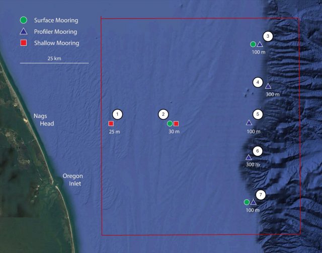 Pioneer MAB Layout[/caption]
Read More
Pioneer MAB Layout[/caption]
Read More NSF’s 2024 Research Infrastructure Workshop
NSF Grants OSU Ocean Research Consortium $220 million
The Daily Barometer reported on a recent National Science Foundation $220 million award to a consortium of ocean research institutions — Woods Hole Oceanographic Institution, Oregon State University and the University of Washington — to carry on the operation and maintenance of the NSF-funded Ocean Observatories Initiative. The funding runs through 2028. Read the article here.
Read MoreNSF Announces Grants Related to OOI Education; Funding Opportunities Remain

The Ocean Sciences Division (OCE) of the National Science Foundation recently announced two awards related to Ocean Observatories Initiative (OOI) education: a renewal of the OOI Data Labs with Rutgers University and a microcredentialing program at the Marine Technology Society (MTS). The Data Labs project offers opportunities for OOI data users’ participation, and the MTS project will provide a widely available microcredential badging opportunity within a few years.
The OOI Data Labs involves representatives of Rutgers University, Stockton University, Hillsborough Community College, City University of New York Queens College, and the Science Education Resources Center at Carleton College, who will support curriculum development and student engagement using advanced technologies of the OOI. Under previous NSF funding, Ocean Data Labs successfully created and tested a lab manual that includes a collection of laboratory exercises using OOI data, as well as holding hands-on workshops where students and faculty learned how to use OOI data to answer ocean-related science questions.
The MTS award will be used to establish a microcredentialing program to address core competencies required for employment in the blue economy. Microcredentials are short, competency-based recognition that allows a learner to demonstrate mastery in specific areas. By 2025, MTS aims to offer six microcredentials, including a foundational microcredential in Underwater Gliders, Remotely Operated Vehicles (ROVs), Sonar, and Deck Operations. Rutgers University and Northwestern Michigan College will be developing the program along with MTS.
“NSF is pleased to support both these projects that promise expanded use of OOI data in the classroom and skills that will promote competency in some of the advanced technology used by OOI to collect data,” said Elizabeth Rom, Program Director of NSF’s Directorate of Geosciences. “We continue to seek innovative proposals that can serve to integrate OOI data more broadly into the learning and scientific community. We are seeking to support efforts that teach researchers or educators how to use OOI data and tools, that develop additional tools or instructional materials using OOI data or that serve to create communities of practice to use OOI data for multi-investigator, community-driven research.”
Rom provide details of three open funding opportunities:
- NSF 22-059 Dear Colleague Letter that encourages curriculum development proposals with the goal of improving the education of the next generation of ocean technicians, data scientists, ocean engineers, and ocean scientists.
- NSF 23-134 Dear Colleague Letter that encourages workshop proposals to develop connections between academic departments and ocean industries, ocean technicians, data scientists, ocean engineers, and ocean scientists.
- NSF 21-24 Dear Colleague Letter encourages research addressing Critical Aspects of Sustainability (CAS) related to climate change solutions. Proposals addressing cross-cutting topics could focus on technology and workforce development with an emphasis on behavioral and social aspects related to climate mitigation and adaptation. Potential relevant topics in red may include:
o Measurement and sensing innovations;
o Artificial Intelligence and other data analytics, computational and statistical modeling and simulation approaches that directly address climate change solutions;
o Understanding the role of human behavior in achieving mitigation strategies;
o Energy and climate education, capacity building, and broadening participation.
Article was posted on October 26, 2023.
Read MoreNational Science Foundation Renews OOI for Another Five Years
The National Science Foundation (NSF) announced that it has awarded a coalition of academic and oceanographic research organizations a second, five-year contract to operate and maintain the Ocean Observatories Initiative (OOI). The coalition, led by the Woods Hole Oceanographic Institution (WHOI), and including the University of Washington (UW) and Oregon State University (OSU), will continue operations of the OOI, a science-driven ocean observing network that delivers real-time data to address critical science questions regarding the world’s oceans.
WHOI has led the operations and management aspects of the OOI since 2018 and will continue to serve as the home for the next five years of the OOI Project Management Office, led by Principal Investigator James B. Edson and Sr. Program Manager Paul Matthias.
The OOI collects and serves measurements from more than 900 autonomous instruments on the seafloor and on moored and free-swimming platforms that are serviced during regular, ship-based expeditions to the array sites. Data from each instrument are transmitted to shore and are freely available to users worldwide, including scientists, policy experts, decision-makers, educators, and the public.
Under this new $220 M investment, each institution will continue to operate and maintain the portion of OOI assets for which it is currently responsible: WHOI will operate the Pioneer Array in the mid-Atlantic Bight off the North Carolina coast, subject to environmental permitting, and the Global Arrays in the Irminger Sea off the southern tip of Greenland and at Station Papa in the Gulf of Alaska; UW will operate the Regional Cabled Array that extends across the Juan de Fuca tectonic plate and through the overlying ocean; and OSU will operate the Endurance Array off the coast of Washington and Oregon. OSU also houses and operates OOI’s Data Center that ingests and delivers all OOI data.
“OOI has proven to be an exceedingly valuable source of information about the ocean,” said NSF Program Officer for OOI George Voulgaris. “Its freely available data are contributing to better understanding of ocean processes and how the ocean is changing. Scientists are using OOI data as the source of cutting-edge scientific discoveries—everything from getting close to predicting underwater volcanic eruptions to changing ocean circulation patterns that have real life implications for weather and fishing patterns. OOI data also are serving as inspiration for students in the classroom, who are excited about learning about the ocean with access to real-time ocean data. We at NSF are proud of our continued investment in making these data available.”
“WHOI is honored to have been selected to continue the mission of the OOI, which is providing valuable ocean data at a time when it is critically needed,” said Peter de Menocal, President and Director of the Woods Hole Oceanographic Institution. “The continued extreme weather events reinforce the importance of this ocean monitoring program to provide science-based data that is accessible to researchers, modelers, agencies, and the public, and we look forward to being part of the continued scientific advancements from this transformational program in the years ahead.”
The Project Management Office at WHOI collaborates with NSF to provide high-level oversight and financial management of the project. In addition, the office coordinates with partner institutions to establish annual priorities for each of the arrays individually and for the network. “The WHOI team and our partners at UW and OSU have learned a great deal over the past five years and are grateful that our efforts to perfect OOI and its data delivery system have been recognized,” said WHOI Senior Scientist Jim Edson, lead principal investigator on the OOI. “We look forward to the next five years where we can continue to perfect our collection and serving of data, while encouraging its increased use and collaboration among ocean scientists funded by NSF and other agencies.”
——————————————
About the Ocean Observatories Initiative
The Ocean Observatories Initiative is a science-driven ocean observing network that delivers real-time data from more than 900 instruments to address critical science questions regarding the world’s oceans. The National Science Foundation has funded the OOI, under Cooperative Agreement No. 1743430, to encourage scientific investigation. OOI data are freely available online to anyone with an Internet connection.
The U.S. National Science Foundation is an independent federal agency that supports science and engineering in all 50 states and U.S. territories.
Any opinions, findings, and conclusions or recommendations expressed in this material are those of the author(s) and do not necessarily reflect the views of the National Science Foundation.
Read More
OOI Data: An Ever Growing Userbase

The collection, archive, and delivery of high-quality oceanographic data to the scientific community is central to the mission of the Ocean Observatories Initiative’s (OOI). Researchers world-wide are taking advantage of the 134 billion rows of freely available OOI data to make discoveries about the oceans and atmosphere. Funded by the National Science Foundation (NSF), the OOI was designed to collect and serve ocean data for up to 30 years. The 30-year timescale makes it possible to measure and observe both short-lived episodic events and longer-term changes occurring in the ocean. Such data are critical to increasing knowledge about ocean processes and if and how the ocean is changing.
How OOI Data Are Being Used
Since OOI data are freely available to anyone with an internet connection, researchers in organizations ranging from small land-locked colleges to major international oceanographic institutions are using OOI data in their scientific investigations. The next generation of ocean scientists are increasingly using OOI data as evidenced by the topics of PhD dissertations and honor theses. The Ocean Data Labs Project also has inspired thousands of students and their college professors to integrate real-time ocean data in the classroom. The project published an OOI Lab Manual, designed for use in introductory oceanography courses providing students and teachers the opportunity to apply timely and even real-time oceanographic data into their studies.
OOI has a broad and increasing science user base, as reflected in the number of OOI-related publications that advancing scientific understanding of ocean processes. The OOI-related publications and the Web of Science citation statistics are compiled by the WHOI-Marine Biological (MBL) Library through Web of Science and Dimensions searches on the main literature databases. The search terms include keywords such as “Ocean Observatories Initiative”, “Irminger Sea Array”, “Global Station Papa”, “Pioneer Array”, “Coastal Pioneer”, “OOI Pioneer”, “Endurance Array“, “Regional Cabled Array”, etc. The subset of publications using OOI data is identified by the OOI PI team. A complete, searchable list of OOI-related publications can be found here.
Table 2: Publications and NSF awards from 1 January 2013 through 31 March 2023
|
Metric |
OOI-related publications in refereed journals | Subset of publications using OOI data or infrastructure |
NSF Awards |
| Number of publications or awards | 326 | 177 | 129 total $66.4M |
| Total Web of Science citations | 4295 | 2250 | Not applicable |
| Sum of Altmetrics scores | 4679 | 2795 | Not applicable |
| Distinct lead authors or PIs | 263 | 146 | 96 |
| Distinct lead institutions | 143 | 73 | 49 |
| Countries | 24 | 16 | USA only |
This process does not necessarily capture all publications that use OOI data, particularly publications that use data obtained from third-party sites that ingest and serve OOI data (e.g., IRIS, Glider DAC and GOA-ON) that would not fall under our keywords. OOI is actively working to improve our ability to identify OOI-related publications by minting DOIs for our data sets.
Even so, this past year’s total for OOI-related publications is the largest to date. The resulting statistics show that OOI data and its infrastructure has been used in 177 peer-reviewed publications since 2013 and has been described, mentioned and/or motivated research in 147 others as shown in Table 1. The number of publications has grown steadily since 2013 as shown in Figure 1. The total given for 2023, represents the first quarter of that calendar year, and we are on tract to meet or beat last year’s total.
[caption id="attachment_26011" align="aligncenter" width="900"]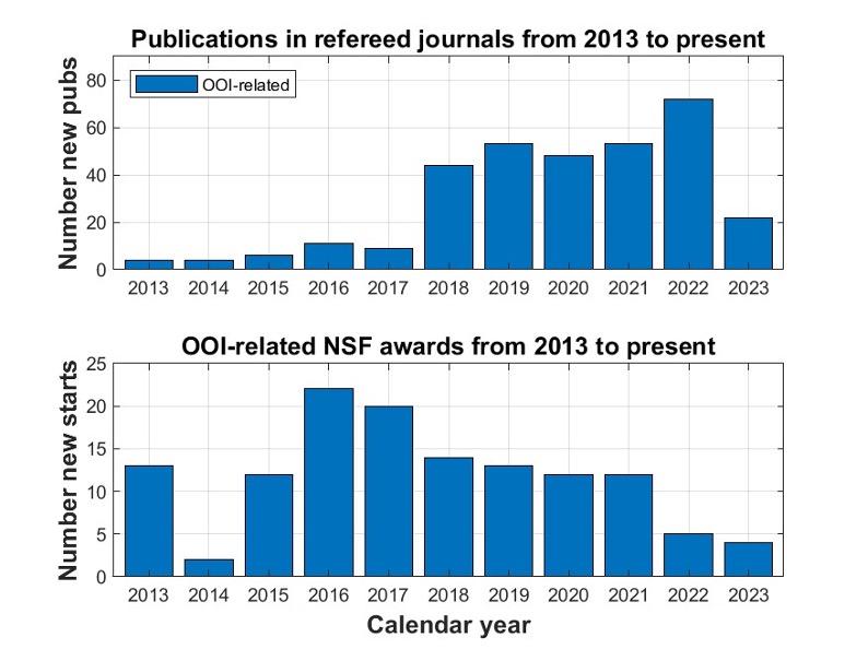
Figure 1. (top panel) the number of publications in refereed journals by year. (bottom panel) The number of OOI-related NSF grants by year. They do not include those grants that support OOI operations and maintenance (O&M).[/caption]
The OOI funding information is obtained from the NSF website by searching awards for “Ocean Observatories Initiative” in their abstracts, selecting those with greater than a particular percentage of relevance and rejecting outliers (such as the OOI O&M and OOIFB awards). Our searches use a cutoff for percentage of relevance of 68%, which provides a meaningful comparison of OOI-related NSF awards from 2013 to the present. The OOI was commissioned in 2016, coincident with the significant jump in NSF-funded OOI-related awards shown in Figure 1. Since that time, the number of awards has slowly dropped, possibly due to impacts from COVID-19. Interestingly, the decrease in NSF awards coincided with rapid growth in publications. We can think of several reasons for this including:
- The freely available OOI data that can be used directly for research without a dedicated NSF (or other) award.
- The use of other funding sources to analyze and publish OOI data.
- The need to expand our search to include other keywords in addition to “Ocean Observatories Initiative.”
We believe that all three play a role in the number of new starts supported by the NSF. This is particularly true of reason (2) for which there is clear evidence in the A Growing Global Reach section provided below.
Improved Accessibility
The OOI has developed an easy-to-use tool to explore and visualize OOI data known as Data Explorer, which was launched in October 2020. The number of users using this tool has been on a steady trajectory of growth since its inception. For example, Figure 2 shows the number of
[caption id="attachment_26014" align="aligncenter" width="900"]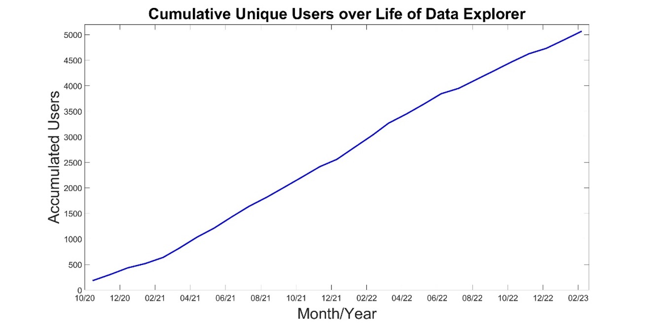 Figure 2. A time series of the accumulated number of unique users since the roll out of Data Explorer in October, 2020. Note, these numbers do not include users who access OOI data via outside data aggregators/distributors such as IRIS, NDBC, IOOS, and the GOOS Glider DAC.[/caption]
OOI Data Explorer unique users since its launch date. A unique user is defined as an individual that comes to the Data Explorer website at least once as defined by Google Analytics. Note that each user is counted only once, i.e., a person who visits Data Explorer a hundred times is counted as one unique user. Today, over 5000 individuals are using our Data Explorer user interface, which represents an average of 175 new users per month. It should also be noted that this total represents the minimum number of OOI users as many long-time users of OOI data continue to use the OOI Data Portal, M2M, our THREDDS and ERDDAP servers, and OOI seismic and hydrophone data from IRIS.
Everyone Benefits
The OOI is not funded to conduct research with OOI data. The OOI’s infrastructure is maintained and operated by Marine Implementing Organizations (MIOs) at WHOI, Oregon State University (OSU), and the University of Washington (UW). These MIOs represent three of the largest oceanographic institutions in the United States and, as expected, researchers in these institutions actively incorporate OOI data in their research (and education). However, they are clearly joined by researchers from many other institutions who also use OOI data as the basis of their scientific findings at shown by Figure 2. This figure shows that three-quarters of publications citing the OOI come from non-MIO institutions, while two-thirds of NSF awards for OOI research goes to non-MIO institutions. It should be noted that the NSF Awards do not include OOI Operation and Maintenance support (O&M) from NSF; i.e., it is just the NSF research grants that mention OOI.
[caption id="attachment_26016" align="aligncenter" width="898"]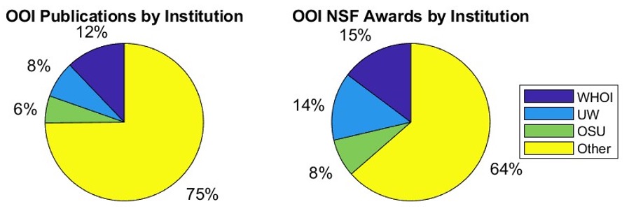 Figure 3. Pie charts showing publications and awards by institutions.[/caption]
A Growing Global Reach
OOI’s global reach is wide and deep. Researchers in 22 countries are using OOI data as shown in Table 1. The global accessibility of ocean data to anyone with an Internet connection allows researchers in land-locked countries and States to study the ocean, without having ever to go to sea. To wit, nations other than the United States are increasingly supporting OOI-related research, as reflected in Figures 4. While the NSF is listed as the source of funding for nearly 40% of the publications shown in the Figure 1, the contributions of other federal agencies, foundations, and nations continue to grow, reflecting the value of the data generated by this vital ocean observatory.
This is even more pronounced if the funding sources are broken down by period. For example, Figure 5 shows the funding source statistics prior to and post CY2019. Approximately half of the publications acknowledge NSF funding from 2013 through 2019. The NSF is acknowledged in approximately one-third of the publication since the start of 2020, which is consistent with the results from Figure 1 (bottom panel). The number of publications that do not acknowledge a source of funding has grown from 4% to 7%, which suggests a growing number of researchers using the freely available data without support. A quick look at these publications shows that several of these are PhD theses. The number of papers acknowledging NSF support is still significant, suggesting that our search is missing some of the new starts and should be modified. More importantly, however, the decrease in NSF acknowledgements coincides with a substantial increase in the acknowledgements of support by European and other countries in their published research. The enhanced stature of the OOI as a global research observatory has resulted in growing collaborations with other observing initiatives such as GOOS, POGO, SOLAS, IOOS and SCOR.
[caption id="attachment_26018" align="aligncenter" width="670"]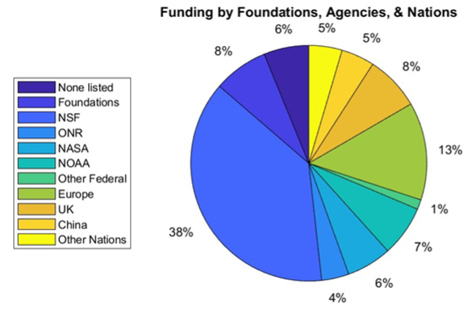 Figure 4. A pie chart showing the foundations, agencies and nations providing support for OOI-related research. Note that the percentages reflect the number of times that these funding sources were acknowledged compared to the total acknowledgements and do not represent the amount of actual funding.[/caption]
[caption id="attachment_26019" align="aligncenter" width="932"]
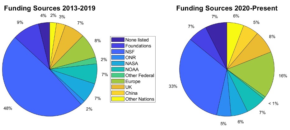 Figure 5. As in Figure 3 but divided into two periods showing acknowledgement of support through 2019 and thereafter.[/caption]
Data Users’ Views
What better way to assess the potential of OOI data than to ask researchers who use it as a foundation for their scientific findings? We share with you some of the views of OOI data users below:
Value of Long-Term Time Series
“The OOI Program offers the opportunity to compare detailed time-series observations of the biological pump across multiple sites, complementing both ship-based process studies (e.g., EXPORTS; Siegel et al., 2016) and more globally wide-spread observations from Biogeochemical-Argo floats and satellites. The OOI arrays represent a diverse set of complementary physical and biogeochemical settings that together could be used to better constrain how interactions between biological and physical processes influence the biological pump.”
– Hilary I. Palevsky, Dept. of Earth & Environmental Sciences, Boston College, Boston, MA, USA
“High resolution and bandwidth ocean observing data from myriad, co-located instrument arrays, such as those provided by the RCA, are crucial to building time series spanning months or years that are required to quantify the flux of methane from the seafloor, possible impacts of ocean warming and seismic events, and the evolution of these highly dynamic environments. Short term or nonsystematic monitoring systems do not provide enough data to produce statistical correlations, nor detect low-frequency cycles with high degrees of confidence. In the years to come, we plan to achieve longer time-series to detect potential non-periodic, low-amplitude influences, possibly from climatic forcing. Such influences can only be reliably inferred with the kind of long-term, systematic sampling methodology made possible by the OOI observatory.”
– Yann Marcon, MARUM – Center for Marine Environmental Sciences, University of Bremen, D-28359 Bremen, Germany
“The six-year record of real-time data flowing from the Regional Cabled Array forms an unparalleled foundation on which to build an ocean drilling program with the International Ocean Discovery Program to understand the relationships between microbial, hydrological, geochemical, and geophysical processes in zero-age, hydrothermally active oceanic crust. Proposed Axial drilling will provide a unique opportunity to determine the nature of subseafloor hydrological properties and develop an unprecedented 3-D understanding of subseafloor processes in unsedimented crust.”
– Julie A. Huber, Marine Chemistry and Geochemistry, Woods Hole Oceanographic Institution, Woods Hole, MA
“The OOI Oregon Shelf site is part of the Coastal Endurance Array. This site, also known as NH-10 as it is located 10 nautical miles offshore along the historic Newport Hydrographic Line, is embedded in the Northern California Current System (NCC). The NCC supports ecologically and economically important fisheries and other marine resources that are impacted by major climate fluctuations: marine heat waves, El Niño, seasonal hypoxia, ocean acidification, and changes in the timing of spring transition to upwelling and fall transition to downwelling. To quantify these types of anomalous events against a baseline of ‘normal’ conditions, we first need decades-long time series to establish what ‘normal’ is (or was). The OOI data collected at the NH-10 site enable us to form these decades-long time series by extending velocity, temperature, and salinity time series from previous programs at NH-10. Together, the OOI data and earlier data form time series that do go back decades, which are very rare for subsurface oceanographic data. The resulting time series can be used to better understand local and basin-scale forcing of physical and biological processes at intra-seasonal, seasonal, interannual, and decadal time scales, as well as detect long-term changes and trends embedded within such variability.”
– Melanie Fewings, College of Earth, Ocean, and Atmospheric Sciences, Oregon State University, Corvallis, OR, USA
Providing Data to Assess Climate Change
“The OOI’s Global Irminger Sea Surface Mooring provided the first multi-winter observations from a high northern latitude surface flux buoy and related them to both localized (100-500 km) intense weather conditions and larger scale (~3000 km) modes of atmospheric variability. The data allowed us to create the first multi-winter characterization of air-sea exchange in the high latitude North Atlantic from observations, including year-to-year variability in the influence of the Irminger Sea tip jet on winter heat loss. We were able to identify a new mechanism by which the atmosphere controls ocean heat loss leading to dense water formation. The results are particularly important as the connection between air-sea exchanges and the ocean circulation is still poorly understood, hindering attempts to understand climate change induced slowdown of the Atlantic circulation and its climate feedbacks.
– Simon A. Josey, National Oceanography Centre, Southampton, UK:
“An important priority for the scientific community is reducing uncertainty in our current quantification of Southern Ocean air-sea CO2 flux and developing the capacity to both predict and monitor how air-sea CO2 flux in this region may change under future climate change. The suite of biogeochemical sensors that were deployed on the OOI Southern Ocean surface mooring provide a unique opportunity to make advances in this quantification of carbon fluxes. In particular, the mooring data provide a valuable opportunity to validate and complement other Southern Ocean in situ carbon system measurements, particularly from biogeochemical Argo floats, as they provide in situ measured wind/atmospheric variables needed to calculate carbon fluxes, high temporal frequency not available on other platforms.”
– Veronica Tamsitt, Climate Change Research Centre, University of New South Wales, Sydney, NSW, Australia and Centre for Southern Hemisphere Oceans Research, CSIRO Oceans and Atmosphere, Hobart, TAS, Australia
“The Regional Cabled and Coastal Endurance Array profiling current meter and CTD data are an incredible novelty for internal tide (ITs) studies, enabling the delineation of the relative contributions of many processes that provide pathways for energy through the ITs and dissipation and mixing. The long duration enables discrimination of processes in frequency that have very similar frequencies, and calculation of the impacts of intermittent inertial waves, long period currents (e.g., eddies; upwelling), and seasonal stratification changes on the shear, strain, and turbulent mixing associated with the ITs. The high vertical resolution enables the differentiation of reversible (i.e., vertical advection) and irreversible (i.e., diapycnal mixing) processes, based on tidal isopycnal displacements. In short, the OOI data offer an incredible opportunity to better understand the critical role ITs play in determining the meridional overturning circulation and oceanic heat budget.”
– Douglas S. Luther, School of Ocean and Earth Science and Technology, University of Hawai’i at Manoa, Honolulu, HI, USA
Improved Understanding of Ocean Processes
“The seismic, geodetic, and hydrothermal data from the OOI Regional Cabled Array at Axial Seamount continues to provide my research group with the opportunity to participate in a thriving community seeking to understand the inner workings of a submarine volcano. The OOI RCA at Axial seamount also provides the long-term observations that help anchor a wide variety of complementary observational studies.”
– William S.D. Wilcock, School of Oceanography, University of Washington, Seattle, WA, USA
“The OOI Pioneer Array at the Mid-Atlantic Bight (MAB) shelf edge provides a unique opportunity for studying subsurface offshore transport of the shelf water. One example is that Pioneer Array moored profilers and gliders captured clear signals of frontal subduction of the shelf water on the edge of an impinging warm-core ring. The subducted shelf water was carried offshore by the anticyclonic ring flow underneath a surface layer of ring water and is invisible on the ocean surface. This form of offshore transport of shelf water had not been realized previously. We used the water mass characteristics captured by the Pioneer Array to develop an ocean model to study the dynamics of the frontal subduction and to quantify the surface-invisible part of the shelf-water offshore transport. Future analysis of Pioneer Array data can provide a more robust quantification of the cross-shelf exchanges at the shelf break and the influence of warm-core rings on the physical and biological properties of the MAB continental shelf.”
– Weifeng (Gordon) Zhang, Applied Ocean Physics & Engineering, Woods Hole Oceanographic Institution, Woods Hole, MA, USA
“At Axial Seamount, the OOI infrastructure combined with constraints on the architecture of the magma plumbing system, provides the opportunity to tie dynamic volcano processes of magma recharge and eruption directly to individual magmatic structures imaged within the volcano interior. It provides the opportunity to answer important questions about how and where melt accumulations form, how melt is transported through the lower crust to feed shallower reservoirs, and how eruptions are triggered. Studies of the deep magma plumbing, conducted within the framework of the even higher-resolution 3D multi- channel seismic imaging data recently acquired at Axial Seamount (Arnulf et al., 2019), would be unprecedented for at any volcano on Earth.”
– Suzanne M. Carbotte, Lamont-Doherty Earth Observatory, Columbia University, Palisades, NY, USA
“Using 4-Dimensional Variational Data Assimilation in a ROMS model (Regional Ocean Modeling System), we undertook a 4-year reanalysis (2014- 2017) of circulation at the Pioneer Coastal Array site. Starting from a 7-km resolution model identical to the MARACOOS ocean forecast system, we refined the resolution through two nested grids to achieve ~700 m horizontal grid resolution in a domain that fully encompasses Pioneer. Though an order of magnitude fewer in number, in situ observations of temperature and salinity from Pioneer moorings and gliders had two to three times the impact of satellite sea level and temperature data on modeled across-shelf fluxes. The study shows that it is feasible to compute very-high-resolution ocean reanalyses that are meaningfully constrained by dense observing networks such as Pioneer. Achieving event-wise correspondence between observed and modeled sub-mesoscale features can provide context to the interpretation of other Pioneer data and opens further opportunities, such as coupling circulation to companion models of biogeochemical and ecosystem processes.”
– John Wilkin, Department of Marine and Coastal Sciences, Rutgers University, New Brunswick, NJ, USA
Read More
Dr. George Voulgaris Appointed New OOI Program Director
The National Science Foundation (NSF) announced the appointment of Dr. George Voulgaris as the new Program Director for the NSF-funded Ocean Observatories Initiative. Voulgaris joins NSF from the School of Earth, Ocean, and Environment at the University of South Carolina, where he was a full professor and held a variety of administrative appointments throughout his career. Voulgaris assumes the OOI leadership role that was jointly provided by NSF Section Heads, Lisa M. Clough, Ocean Section, and Bauke (Bob) H. Houtman, Integrative Programs since 2016. Bob retired at the end of 2022, but Lisa continues to support George in his new role and remains engaged with the OOI Facility.
This position marks a return to NSF for Voulgaris who served as a Program Director for NSF’s Physical Oceanography Program from July 2017 to August 2020.
Lisa Clough said, “Bob and I are excited to be turning over the reins of the OOI at NSF to George, who is very well-suited to the task. George has more than 30 years-experience in ocean observations systems, as well as 3+ years of experience as an NSF program director. With this experience, he brings to OOI the unique perspective of understanding what quality ocean observations require from standpoint of a system operator, scientist and educator, and as a federal funder. Unquestionably, George will help the OOI deliver on its mission to be one of the world’s premier ocean observing systems.”
Voulgaris plans to facilitate the work of OOI operators and the OOI Facility Board (OOIFB) as both respond to the challenges and opportunities informed by the broader oceanographic community. “Coming from an institution with no major oceanographic facilities, I have a great appreciation of the opportunities OOI provides to faculty, researchers, and students with no access to such facilities,” Voulgaris explained. “I hope to help OOI continue to provide these services and further enhance its impact through new scientific discoveries and synergies with other partners vested in ocean discovery and through new emerging technologies. I am excited be a part of OOI as its impact grows both nationally and internationally.”
Voulgaris joined the University of South Carolina as Assistant Professor in 1998 and was promoted to the ranks of Associate and Full Professor in 2005 and 2008, respectively. His research is in the area of Coastal Processes incorporating aspects of both Marine Geology and Physical Oceanography. His many externally funded research projects (e.g., NSF, National Oceanic and Atmospheric Administration, the Department of the Interior) range from exploring the surf-zone to continental shelf circulation and often include assessing sediment transport and wave-current interactions, using hydrodynamic and turbulence measurements in the field and laboratory. For the last decade, he has been active in operational oceanography utilizing coupled wave and current numerical models and HF and VHF Radar measurements for measuring surface currents and ocean waves.
Voulgaris has authored or co-authored over 100 peer-reviewed manuscripts, 130 published abstracts and 45 technical reports, source-codes, and other non-refereed publications. In recognition of his research contributions, he was awarded the University of South Carolina Research Foundation award for Science and Mathematics in 2014. Voulgaris has served as a member of the Scientific Committee of the Key Laboratory for Coast and Island Development, Ministry of Education, Nanjing University, China, and on the Board of Directors for the Southeast Coastal Ocean Observing Regional Association. Voulgaris is also a member of the American Geophysical Union, the American Association for the Advancement of Science, and the Marine Technology Society.
Voulgaris received a bachelor’s degree in Geology from the University of Patras in Greece and a Ph.D. in Oceanography from the University of Southampton in the United Kingdom.
The Ocean Observatories Initiative is a 25-year ocean infrastructure project funded by the National Science Foundation to gather and deliver physical, chemical, and biological measurements from the ocean, atmosphere, and seafloor to anyone with an internet connection. The program includes moored instrument arrays and autonomous underwater vehicles deployed at critical locations in the coastal and open ocean worldwide. Data from the observatories help researchers address questions across short and long time periods, small and large spatial scales, and from the ocean surface to the seafloor. OOI is managed by the Woods Hole Oceanographic Institution (WHOI) and implemented by WHOI, the University of Washington, and Oregon State University.
Read More
NSF Issues Dear Colleague Letter to Support Ocean Technical Workforce Education
The National Science Foundation (NSF) issued a “Dear Colleague Letter” (DCL) on March 14, 2022 seeking proposals for curriculum development and student engagement to support the expansion of the ocean technical workforce. Through the DCL, NSF hopes to expand the technical capacity of the U.S. workforce in high-technology fields through training programs that educate the next generation of ocean technicians, data scientists, ocean engineers, and ocean scientists.
Proposal topics of high priority include training in ocean instrumentation design, manufacturing and maintenance of marine-related hardware, and ocean data science and data analytics. Submissions are encouraged that target documented gaps in the U.S. technical workforce in marine instrumentation and manufacturing sectors, including those related to renewable energy, such as wave, tide, wind, and solar energy systems.
Full details can be found here. Proposers are encouraged to contact the program officers prior to submitting proposals or requests for supplemental funding. For questions about this DCL, please contact Elizabeth (Lisa) Rom – elrom@nsf.gov in the Division of Ocean Sciences, Jumoke Ladeji-Osias – jladejio@nsf.gov in the Directorate of Engineering, or V. Celeste Carter – vccarter@nsf.gov in the Division of Undergraduate Education.
Read More
Funding Opportunity for OOI Education, Workshops, Training Proposals
To encourage wider use of OOI data by researchers and educators, the Ocean Sciences Division (OCE) of the National Science Foundation is seeking proposals for projects that use OOI data. Funding is available to support workshops, conferences or other training events that introduce researchers and educators to the type of data available through OOI and community tools that have been developed to use that data.
A Dear Colleague Letter (NSF20-047) issued in early 2020 remains in effect.
“We are seeking to support efforts that teach researchers or educators how to use OOI data and tools, that develop additional tools or instructional materials using OOI data or that serve to create communities of practice to use OOI data for multi-investigator, community-driven research, “ said Elizabeth Rom, an OCE Program Director who oversees a number of NSF educational initiatives.
At a recent town hall of the Ocean Observatories Initiative Facility Board at the AGU Fall Meeting, Rom presented a progress report on proposals funded since May 2020. These include:
- Two Ocean Hack weeks held at the University of Washington and Bigelow Laboratory for Ocean Sciences. In 2020, the workshop was virtual, in 2021 the workshop was a hybrid.
- OOI Biogeochemical Data Workshop, which consisted of an online meeting in July 2021 and plans for an in-person meeting for June 2022 at Woods Hole Oceanographic Institution.
- K12 OOI Workshop Series that involves the South Kitsap School District in Washington state and Deb Kelley at the University of Washington. The goals of the workshop series are to develop teacher cohort and lesson plans using OOI data in classrooms. The series launched in early December with virtual and in-person sessions planned throughout 2022.
She also reported on progress in course development, including support of a second cohort of faculty to develop version 2 of the Ocean Data Lab’s online manual, microbial monitoring using OOI RCA remote samplers at Axial Seamount, and development of instructional materials and piloting assessment instruments to explore undergraduate scientific literacy. NSF programs GeoPaths (Pathways into the Earth, Ocean, Polar and Atmospheric and Geospace Sciences) and Research Experiences for Undergraduates (REU) sites also provided opportunities for using OOI data. An initiative to broaden the scope and increase the efficacy of the SERC Discovery System was supported, as were multiple REU student projects in 2020 and 2021.
“While COVID served to discourage in-person meetings and workshops, we were pleased that so many innovative approaches were proposed,” added Rom. “Hopefully in 2022, we will have opportunities to for virtual, hybrid and in-person workshops, and certainly the innovation of this community will shine through.”
Two- and four-year U.S. institutions of higher education and U.S. non-profit non-academic organizations are eligible to submit proposals. Proposals may be submitted at any time, but Principal Investigators are encouraged to submit at least six months prior to the planned event. Submission details are available here. While the DCL refers to Fiscal Year 2020, it continues to be in effect until canceled.
Read More