
Posts Tagged ‘Southern Mid-Atlantic Bight’
Test Deployments Underway for Pioneer Relocation
Tuesday February 21, 2023, a team of scientists and engineers from Woods Hole Oceanographic Institution (WHOI) left Charleston, SC aboard the R/V Neil Armstrong to begin test deployments in preparation for the installation of an Ocean Observatories Initiative (OOI) ocean observing system in its new location in the southern Mid-Atlantic Bight (MAB). The science team will deploy two test moorings off the coast of North Carolina, occupying shallow and deep sites of the proposed array. The deployments will supplement computer modeling to ensure the mooring designs perform as expected in the MAB environment. Once the array is fully operational in 2024, the ocean data collected will be available online in near real-time to anyone with an Internet connection.
Ocean observing data helps to track, predict, manage, and adapt to changes in the marine environment. Coastal communities use ocean observing data to prepare for floods and other natural disasters. The instrumented arrays gather physical, chemical, geological, and biological data from the air-sea interface to the seafloor, providing a wealth of information for research and education.
[media-caption path="https://oceanobservatories.org/wp-content/uploads/2023/02/CNSM_buoy_atsea-2-1.png" link="#"]Offshore conditions can be brutal for moorings that remain in the water for six-month deployments. The new location for the OOI’s Coastal Pioneer Array is designed to withstand treacherous conditions, including extreme storms. Credit: ©Woods Hole Oceanographic Institution.[/media-caption]“This new Pioneer Array location in the MAB offers many opportunities for scientists to obtain data to further their research, and will provide better insight into conditions in the area for a variety of stakeholders,“ said Al Plueddemann, Project Scientist for OOI’s Coastal and Global Scale Nodes group at WHOI, which is responsible for operation of the Pioneer Array. “We welcome researchers, educators, and industry members to reach out to us to explore ways we might work together to maximize the usefulness of the data.”
The OOI is funded by the National Science Foundation (NSF) to collect and deliver ocean data in select locations for 25 years or more. This longevity of data collection makes it possible for researchers to identify both short term processes and long-term trends in our changing ocean. The OOI’s Coastal Pioneer Array was designed to be relocatable, and its first deployment was off the coast of New England at the Continental Shelf/Slope interface, where it collected data from 2016 until it was recovered in September 2022. The new location off the coast of North Carolina was chosen by NSF based on input from the science community during a series of NSF-sponsored workshops in 2022.
Dr. Reide Corbett, Executive Director of the Eastern Carolina University’s Coastal Studies Institute (CSI), is enthusiastic about the opportunities the Pioneer Array will bring to the region. “The cross-shelf suite of instrumentation off northeastern North Carolina’s coast is in a region of complex physics and critical ecosystem dynamics that draws interest from many disciplines and creates opportunities for transformational science. This is also in a region with a growing renewable energy sector, including two active offshore wind leases, with opportunities to partner with the agencies involved. The Coastal Studies Institute is excited about the observations that will be made from these instruments, allowing us to better address climate change influences in the coastal ocean, and improve ocean/weather/storm forecasts through data sharing. Beyond just the instruments in the water, the new partnerships and collaborations created as part of this deployment will provide the ability to better engage this socio-economically diverse region, with disadvantaged groups more impacted by sea level rise and climate change compared to many coastal regions. This broad network of partnerships across the region will provide a mechanism to drive knowledge to action,” states Corbett.
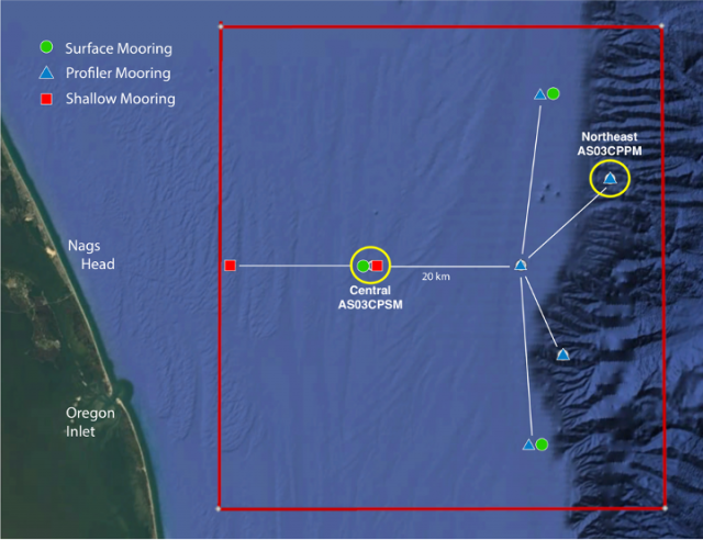
[media-caption path="https://oceanobservatories.org/wp-content/uploads/2023/02/Pioneer-MAB-schematic.png" link="#"]Schematic drawing of the Pioneer MAB moored array to be deployed off the coast of Nags Head, North Carolina. The full array, to be deployed in the spring of 2024, will consist of ten moorings at seven different sites (three sites contain mooring pairs). For the test deployment, one Coastal Surface Mooring will be deployed at the Central site and one Coastal Profiler Mooring will be deployed at the Northeast site.[/media-caption]The new MAB site represents a different environment than the New England Shelf location and offers opportunities to collect data on a variety of cross-disciplinary science topics, including cross-shelf exchange and Gulf Stream influences, land-sea interactions associated with large estuarine systems, a highly productive ecosystem with major fisheries, processes driving biogeochemical cycling and transport, and fresh-water outflows during extreme rain events.
The MAB location is expected to have different wind, wave, and current conditions than the Pioneer Array experienced on the New England Shelf. In addition, deployments in the new location will be in both shallower and deeper water depths than those off the New England coast.
A Coastal Surface Mooring (CSM) will be deployed at 30 meters depth at 35o 57.00’ N, 75o 07.5’ W. The CSM is specifically designed to examine coastal-scale phenomena and withstand the challenging conditions of shallow coastal environments. The Surface Mooring contains instruments attached to a Surface Buoy floating on the sea surface, a Near Surface Instrument Frame 7 meters below the surface, and a Seafloor Multi-Function Node (MFN) located on the seafloor. Additionally, the Surface Buoy contains wind turbines and solar panels for power generation and antennas to transmit data to shore via satellite.
A Coastal Profiler Mooring (CPM) will be deployed at 600 meters depth, 36o 03.80’ N, 74o 44.56’ W. The CPM contains a Wire-Following Profiler that houses instruments. The Wire-Following Profiler moves through the water column along the mooring riser, continuously sampling ocean characteristics from about 23 m below the surface to 23 m above the sea floor. The CPMs also carry an upward-looking Acoustic Doppler Current Profiler to measure ocean currents over the same region of the water column traversed by the profiler.
The test mooring data will be evaluated during the deployment and after recovery to determine whether any modifications are needed to the mooring designs. The plan is to deploy the full array in the spring 2024.
An update on the Pioneer Array relocation is planned for April 20 at 6 pm at the Coastal Studies Institute on East Carolina University’s Outer Banks Campus. Contributing to the CSI “Science on the Sound” lecture series, WHOI’s Dr. Plueddemann will discuss the Pioneer Array infrastructure, instrumentation, and what is planned for its upcoming move off the North Carolina coast. The event is free and open to the public. For those unable to attend, the program will be live-streamed, as well as archived for later viewing, on the CSI YouTube Channel.
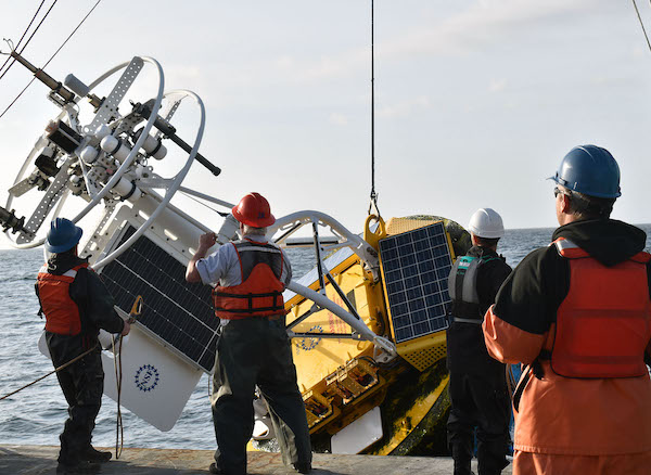
[media-caption path="https://oceanobservatories.org/wp-content/uploads/2023/02/A-Frame.png" link="#"]An A-frame at the stern of the ship is used to lift an OOI Coastal Surface Mooring into the water at the start of the deployment. A team secures guidelines to ensure its movements are controlled. Credit: Darlene Trew Crist © WHOI.[/media-caption] [media-caption path="https://oceanobservatories.org/wp-content/uploads/2023/02/DSC0418-scaled.jpg" link="#"]Surface Mooring Recovery operations. Credit: Deidre Emrich © WHOI.[/media-caption]
Read More
Successful Last Deployment of Pioneer Array on NE Shelf
The Pioneer 18 Array team and crew of the R/V Neil Armstrong pulled into the dock at Woods Hole, MA, on April 27, a day earlier than expected, having completed all objectives of the expedition. Their mission included the last deployment of the Pioneer Array at its current location on the New England Shelf. The Pioneer Array components now in the water will be recovered in November 2022 and redeployed in the Southern Mid-Atlantic Bight in the Spring of 2024.
The expedition consisted of two legs. On leg #1, three Coastal Surface Moorings and multiple gliders were recovered and deployed and autonomous vehicle missions were completed. On leg #2, the team deployed five Coastal Profiler Moorings. Three Coastal Surface Moorings and seven Coastal Profiler Moorings were recovered, two of which could not be recovered during an earlier expedition because of weather conditions. The recovered equipment will be taken apart, refurbished, and in some cases, reconfigured for deployment at the new location.
Weather conditions allowed for multiple deployments of a remotely operated vehicle, to help assess the condition and assist in the recovery of mooring components that could not be recovered by standard techniques (using an acoustically-triggered release). The team also conducted additional activities that ranged from water sampling adjacent to the moorings to cross-shelf CTD (conductivity, temperature, and depth) surveys in the vicinity of the moored array, and surveys using shipboard sensors. A variety of ancillary activities, accommodating eight participants from five different institutions, were also facilitated during the cruise.
Al Plueddemann, Principal Investigator of the Coastal and Global Scale Nodes (CGSN) and Chief Scientist of Pioneer 18 said, “The successful completion of this expedition again demonstrates the capabilities and experience of the CGSN team and the R/V Armstrong, and bodes well for successful operation of the Pioneer Array in its new location in the Southern Mid-Atlantic Bight.”
[media-caption path="/wp-content/uploads/2022/05/last_NES_CPM_PMUI-17-copy.jpg" link="#"]The Coastal Profiler Mooring shown here, PMUI-17, will be the last Pioneer mooring deployed on the New England Shelf. After providing data through the summer and early fall, the current array will be recovered in November of 2022 and relocated to the Southern Mid-Atlantic Bight in 2024. Credit: Jess Kozik©WHOI.[/media-caption]
The Pioneer Array was originally commissioned in 2016 as a re-locatable coastal array suitable for moderate to high wind, wave and current regimes on the continental shelf and upper slope. The new location in the Southern Mid-Atlantic Bight was decided upon after a series of workshops in 2021, co-sponsored by the National Science Foundation and the Ocean Observatories Initiative Facility Board, to gain community input on a new location that would best address pressing science questions.
Plueddemann added, “The Pioneer Array has collected a remarkable data set from the New England Shelf, which scientists will continue to use to understand frontal dynamics and related ecosystem impacts in this important and dynamic region.”
[media-caption path="/wp-content/uploads/2022/05/heads_up-copy.jpg" link="#"]When the large Coastal Surface Mooring buoys are recovered everyone pays close attention. The buoy tower spins when the hull is picked out of the water, and the deck team needs to be ready with a snap hook to clip into the circular rails on the tower top and arrest the motion. Credit: Andrew Reed ©WHOI.[/media-caption]
As the Pioneer 18 team headed home, another CGSN expedition is about to hit the water. A team of scientists and engineers is already traveling to Seward, Alaska to mobilize for another OOI expedition. On May 12, they will be aboard the R/V Sikuliaq for a 19-day expedition to the Global Station Papa Array, in the Gulf of Alaska, about 620 nautical miles offshore. This team will deploy five moorings — three for OOI and one each for the National Oceanic and Atmospheric Administration and the University of Washington. Once on site, the team will first deploy the moorings onboard, then recover those that have been in the water for a year. Upon completion, the ship will transit to the demobilization port of Seattle, Washington. Bookmark this site, and follow along on their progress.
Read More