
Posts Tagged ‘William Wilcock’
Is Axial Seamount Napping?
Oregon State University Researcher Bill Chadwick attempted to answer this question in a poster he presented at AGU in December 2023. Chadwick has been watching the “ups and downs” of Axial Seamount for more than 30 years, including its last eruption in 2015. He and other observers monitor the seamount’s activity using bottom pressure recorders (BPR) connected to the US National Science Foundation Ocean Observatories Initiative (NSF OOI) Regional Cabled Array (RCA), operated by the University of Washington, along with additional uncabled BPRs and Mobile Pressure Recorder surveys at an array of seafloor benchmarks every two years using a remotely operated vehicle.
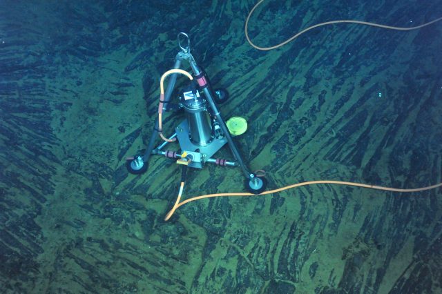
[media-caption path="https://oceanobservatories.org/wp-content/uploads/2024/03/BPR-scaled.jpg" link="#"]A repeatable inflation-deflation cycle has been documented at Axial Seamount over the last 30 years, using autonomous, battery-powered Bottom Pressure Recorders (BPRs), and later cabled-BPRs like this one connected to the OOI-RCA. Credit: UW/NSF-OOI/CSSF, 2014.[/media-caption]“Axial Seamount has erupted three times in the last 25 years. As of March 2024, the seamount is 90-95% reinflated to the level it reached before the 2015 eruption, so we’re getting close to the eruption triggering point,” said Chadwick. “But on the other hand, the rate of inflation, which started high right after the 2015 eruption, has been decreasing and decreasing since then.”
The inflation rate reached nearly zero last summer (just slightly positive at ~1 cm/year, the lowest rate seen at Axial). “At that very low rate, it was hard to tell how long it would take to reach the 2015 inflation threshold,” Chadwick added.
Since October 2023, however, the rate of uplift has been slowly increasing. University of Washington Researcher William Wilcock’s Axial Seamount Earthquake Catalog page also indicates the seismicity has been on the rise since October 2023, with a large swarm of >600 events on 10 February.
“Since October 2023, the rate of inflation has increased a bit to 5-6 cm/yr, which is still quite low compared to rates we’ve seen over the last 25 years but seems to indicate that Axial may be coming out of its slumber of last summer,” Chadwick explained. “And the earthquake swarm on Feb 10 also seems to support that notion.”
Longer-term eruptive history documented by mapping and dating lava flows at the summit shows that Axial has produced at least 50 eruptions in the last 800 years, (Clague et al., 2013), an average of one every 15-18 years, suggesting that the current lull at Axial might not be long.
“I’m hoping that the rate of inflation will continue to increase, but it’s too early to tell. Anything could happen,“ Chadwick added. “I’m more hopeful than I was a year ago that the next eruption may not be too far off but only time will tell!”
[media-caption path="https://oceanobservatories.org/wp-content/uploads/2024/03/Chadwick-dots.jpg" link="#"]Map showing the locations of Mobile Pressure Recorder (MPR) benchmarks, as well as the autonomous and cabled Bottom Pressure Recorders (BPR). The red dots are the BPRs connected to OOI Regional Cabled Array.[/media-caption]
Reference: Clague, D.A., et al., (2013) Geologic history of the summit of Axial Seamount, Juan de Fuca Ridge, Geochem Geophys, Geosystems, doi: 10.1002/ggge.20240.
Read More
NSF Funds Creation of Offshore Subduction Zone Observatory as part of OOI’s Regional Cabled Array
With support from the US National Science Foundation, the Ocean Observatories Initiative’s (OOI) Regional Cabled Array (RCA) will be expanded to include an Offshore Subduction Zone Observatory on the Cascadia margin. This new addition to the RCA will produce real-time data to help answer fundamental questions about how subduction zone faults work and can enhance existing systems for earthquake and tsunami warning.
The University of Washington (UW) will lead a team that includes Scripps Institution of Oceanography to implement the “Creating an Offshore Subduction Zone Observatory in Cascadia with the Ocean Observatories Initiative Regional Cabled Array” (COSZO) project to add geohazard sensing instruments, including seismic sensors and calibrated seafloor pressure gauges, to the existing NSF-funded Regional Cabled Array. The UW received one of four Mid-Scale Research Infrastructure-1 (Mid-scale RI-1) awards announced by the US National Science Foundation for Fiscal Year 2023-2024.
“The four awardees NSF has selected — the University of Rochester, Iowa State University, the University of Washington, and the University of Southern California — exemplify the most novel, innovative infrastructure being designed and built in our country to advance the best ideas and train the highly skilled talent in science and engineering for our future,” said NSF Director Sethuraman Panchanathan. “By investing in the most innovative infrastructure, NSF aims to strengthen opportunities for all Americans and advance the frontiers of science and technology.”
Earth’s greatest geological hazards are concentrated in subduction zones. These places where two tectonic plates converge and collide not only produce large-scale earthquakes but suffer from their cascading effects such as devastating tsunamis. The Cascadia subduction zone, spanning the offshore coasts from northern California to British Columbia, hosts earthquakes up to magnitude 9 every few hundred years, the last of which was in 1700. The RCA currently brings power and internet into the ocean offshore of Newport, Oregon.
Today seismic and geodetic sensor networks on land in the Pacific Northwest can quickly alert authorities to geohazards, but the offshore region, where almost all the locked plate boundary and expected earthquake slip would occur, is largely devoid of such instruments.
“There’s a huge amount of interest in subduction zones, from Sumatra to Chile,” said oceanographer William Wilcock, one of several investigators on this project. “Because of the risks and hazards of subduction zones, the National Science Foundation and others have invested in studies to understand a wide variety of subduction zones because they all behave a bit differently and can have devastating impacts.”
“This award will make it possible for scientists to have a front-row seat of the subduction zone with real-time data from 2900 to 80 meters below the ocean’s surface” said Deborah Kelley, Principal Investigator of the Regional Cabled Array. “It builds upon some of the ideas that motivated the OOI. It clearly demonstrates the opportunities for growth through the RCA’s ability to provide power and unprecedented bandwidth to instruments that are monitoring conditions around the clock on the seafloor and throughout the water column. From this will come important new discoveries about how our planet works.”
“We are excited by the addition of COSZO to the Regional Cabled Array,” said Jim Edson, who leads OOI’s Program Office at Woods Hole Oceanographic Institution. “The data made available from COSZO via NSF’s Seismological Facility for the Advancement of Geoscience, will help scientists and engineers understand the hazards from earthquakes and tsunamis, with the potential for improvement of early warning systems, which can ultimately help save human lives. “
A story about the COSZO project can be found here.
——————————————
The Ocean Observatories Initiative is a science-driven ocean observing network that delivers real-time data from more than 900 instruments to address critical science questions regarding the world’s oceans. The National Science Foundation has funded the OOI, under Cooperative Agreement No. 1743430, to encourage scientific investigation. OOI data are freely available online to anyone with an Internet connection.
The U.S. National Science Foundation is an independent federal agency that supports science and engineering in all 50 states and U.S. territories.
Any opinions, findings, and conclusions or recommendations expressed in this material are those of the author(s) and do not necessarily reflect the views of the National Science Foundation.
October 19, 2023
Read More
Catching the Next Eruption of Axial Seamount
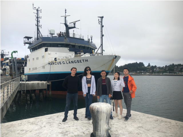
Theresa Sawi, a PhD student in Columbia’s Department of Earth and Environmental Sciences and the Lamont-Doherty Earth Observatory, shares her reflections and more about the science behind a six-day research expedition to Axial Seamount. She gives a behind the scenes look as researchers from Columbia University on the R/V Marcus G Langseth deployed 15 autonomous ocean-bottom seismometers atop Axial Seamount, a submarine volcano in the northeast Pacific Ocean that erupted in 1998, 2011, and 2015. The research expedition was part of a two-year experiment taking place within the predicted time window of the next eruption.
The seismometers were added to OOI’s Regional Cabled Array. To read Sawi’s account, click here.
[media-caption path="/wp-content/uploads/2022/09/Langseth.png" link="#"]15 scientists were onboard the Langseth, with ranks ranging from professor to undergraduate researcher. Credit: Theresa Sawi.[/media-caption]Read More
Distributed Acoustic Sensing Lays Groundwork for Earthquake, Tsunami Warnings, and More
Researchers using the OOI Regional Cabled Array are at the forefront of testing Distributed Acoustic Sensing (DAS) along the seafloor through funding from the National Science Foundation. Ocean-bottom DAS using submarine fiber optic cables promises to advance what we know about marine geology, offshore earthquakes, ocean currents, ocean waves, sediment transport, marine mammals, and a host of other activities that now can be measured by this revolutionary technique.
Taking advantage of a rare temporary shutdown of RCA’s submarine fiber optic cables during a shore station maintenance period, University of Washington Researcher William Wilcock and California Institute of Technology (Caltech) Graduate Student in Geophysics Ethan Williams were part of a team of scientists who installed DAS interrogators on RCA’s “dark cables” to test and collect data for a community experiment. The experiment was designed to determine the potential of submarine DAS to observe seismic, oceanographic, acoustic and geodetic processes. Each interrogator transmitted laser pulses down the fiber optic cable from RCA’s shore station and across the offshore Cascadia Margin and recorded the echoes that came back. This backscatter remains constant until some movement on the bottom or in the water column perturbs the fibers in the cable, changing the pattern of backscattered light. By rapidly probing the cable hundreds of times per second, DAS allows researchers to monitor what’s happening in the cable environment.
“Using DAS, the fiber optic cable acts, in effect, like a line of seismometers that can measure the stretching and contracting of the ground, “explained Wilcock. “It’s an amazing technology, similar to going out in the field and putting a seismic instrument every 10 meters for a stretch of 100 kilometers. So it’s just astounding in terms of what it can potentially measure,” said Wilcock.
The DAS system also has the capability of measuring other oceanographic signals. “It turns out that ocean bottom acoustic sensing on these fiber optic cables is as sensitive to the water layer above as it is to the solid Earth below. This sensitivity provides all sorts of really interesting signals that you would normally observe using an ocean bottom pressure sensor. DAS is opening up the door for lots of interesting research opportunities,” said Williams, who has been working with DAS systems for years under the supervision of Zhongwen Zhan at Caltech, one of the world’s foremost experts in the field.
Among the many potential ways DAS data might be used include advancing earthquake and tsunami early warning systems, and understanding wave and current action, sediment transport, and ocean-generated seismic noise, as well as providing biological information. In Wilcock’s case, he’s excited about using DAS to gain access to fin whale calls that were picked up by this DAS experiment.
The National Science Foundation funded this experiment in the hopes of developing protocols that can support the use of DAS for science and hazards mitigation in the Northeast Pacific while meeting national security requirements. The U.S. Navy conducted a preliminary review of the data and subsequently released the data for public use. The data are being stored on RCA servers at the University of Washington. Researchers will have ftp access to the data at this link. But because the full data set is 26 terabytes, researchers can also email ooicable@uw.edu to arrange to provide disks that will be returned with data they are interested in.
Four days of continuous measurements in this dynamic offshore environment also offer a potential treasure trove of data. Graduate student Williams is turning his attention to exploring these datasets and calibrating them against conventional measurements to better understand what some of the potential applications may be. “I’m very excited about the potential DAS brings to understanding what’s happening on the seafloor. Having, in essence, so many seismometers on the ocean floor means that we can apply all sorts of array-based processing so we’re not only averaging in time, we’re combining information in space. And this allows a lot of really innovative things that we weren’t able to do before.”
“But the real value of these datasets comes from being an open dataset. It will be a great facilitator for learning with the potential to expand general knowledge about how to use DAS in the marine geology and marine geophysics world, which is great,” Williams added.
Both Wilcock and Williams were excited about the potential for DAS to open up understanding of the processes involved in this deep-sea world. They both mentioned a dream of having DAS sensors integrated into future SMART cable technology to expand DAS use on land and in the sea.
Read More