
Posts by ooistaff
OOI Designated as a UN Ocean Decade Endorsed Project
On June 8, 2022, World Oceans Day, the United Nations Educational, Scientific and Cultural Organization (UNESCO) designated the Ocean Observatories Initiative (OOI) as a UN Endorsed Action as part of the UN Decade of Ocean Science for Sustainable Development 2021-2030 (The Ocean Decade). Endorsed status presents opportunities for wider collaboration and enhanced ability to tackle grand challenges in better understanding the ocean. The announcement was timed to add to global celebrations of the UN World Oceans Day, which was organized this year around the theme “Revitalization: Collective Action for the Ocean.”
With the aim of achieving the Ocean Decade vision of “The science we need for the ocean we want,” the newly endorsed Decade Actions address priority issues worldwide, including marine pollution, management and restoration of marine ecosystems and the ocean-climate nexus—all with the goal of achieving a better understanding of the ocean system, and of delivering science-based solutions to inform decision-making from the international to the individual level.
“We are delighted that the importance of OOI’s data contributions to improving understanding of the changing ocean was recognized by the UN Decade. We very much look forward to broader opportunities to share our data with global colleagues,” said OOI Principal Investigator James B. Edson, lead of OOI’s Program Office at Woods Hole Oceanographic Institution (WHOI). WHOI operates OOI in partnership with the University of Washington and Oregon State University.
“The themes and objectives of the UN Decade of Ocean Science are tailor-made for scientists, engineers, and technicians who access OOI measurements to advance the state of our knowledge in ways that will ensure a long-term, sustainable path for society and a thriving, healthy ocean. For the coming decade and beyond, our goal is to make the ocean more accessible and to turn what we learn into meaningful, actionable information available to all,” added Edson.
Funded by the National Science Foundation, OOI was designed as a long-term project to collect ocean data for up to 25 years or more. This longevity makes it possible to measure and directly observe both short-lived episodic events and longer-term changes occurring in the ocean. Such data makes it possible to better understand ocean processes that support society and ecosystems and how the ocean is changing.
About the Ocean Decade
Proclaimed in 2017 by the United Nations General Assembly, the UN Decade of Ocean Science for Sustainable Development (2021-2030) (‘the Ocean Decade’) seeks to stimulate ocean science and knowledge generation to reverse the decline of the state of the ocean system and catalyze new opportunities for sustainable development of this massive marine ecosystem. The vision of the Ocean Decade is ‘the science we need for the ocean we want’. The Ocean Decade provides a convening framework for scientists and stakeholders from diverse sectors to develop the scientific knowledge and the partnerships needed to accelerate and harness advances in ocean science to achieve a better understanding of the ocean system, and deliver science-based solutions to achieve the 2030 Agenda. The UN General Assembly mandated UNESCO’s Intergovernmental Oceanographic Commission (IOC) to coordinate the preparations and implementation of the Decade.
About the IOC-UNESCO
The Intergovernmental Oceanographic Commission of UNESCO (IOC-UNESCO) promotes international cooperation in marine sciences to improve management of the ocean, coasts and marine resources. The IOC enables its 150 Member States to work together by coordinating programs in capacity development, ocean observations and services, ocean science and tsunami warning. The work of the IOC contributes to the mission of UNESCO to promote the advancement of science and its applications to develop knowledge and capacity, key to economic and social progress, the basis of peace and sustainable development.
OOI Hydrophone Data Helping ID Whale Calls
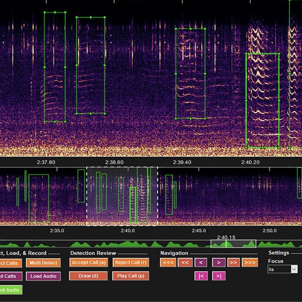
Elizabeth Ferguson of Ocean Science Analytics used OOI hydrophone data with DeepSqueak – a computer program designed to sort mice squeaks that is also finding whales in the deep.
She was interviewed about her work by Joe Palca on Morning Edition of NPR o n May 31, 2002. Listen to the report here.
Read More
Station Papa Collaborative Expedition Completed
Ten scientists and engineers. Nineteen days at sea. Approximately 620 nautical miles offshore in the Gulf of Alaska. Six successful mooring deployments — three for the Ocean Observatories Initiative (OOI), two for the National Oceanic and Atmospheric Administration (NOAA), and one for the University of Washington (UW).
The Station Papa 9 team aboard the R/V Sikuliaq demobilized in Seattle, Washington on May 31 after a 19-day expedition to the Global Station Papa Array, in the Gulf of Alaska. In addition to the recovery and deployment of three OOI moorings (Global Hybrid Profiler, two Global Flanking Moorings), the team successfully completed two mooring recoveries and deployments for NOAA (a surface mooring and noise reference station) and UW (a Waverider, which measures surface waves). The team also carried out shipboard underway sampling, including collection of water samples, to support field calibration and validation of the platforms and sensors in the array.
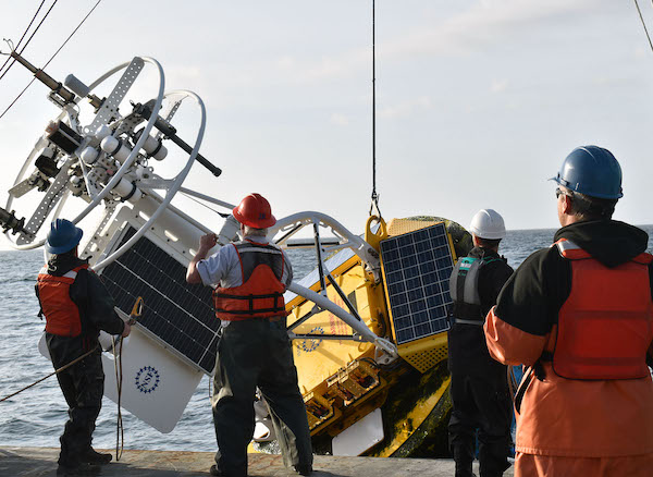
[media-caption path="/wp-content/uploads/2022/05/Picture1.png" link="#"]The Station Papa moorings are outfitted with instruments that measure conductivity, temperature and depth, (CTD) dissolved oxygen, pH, fluorescence, acoustic backscatter (for characterizing zooplankton), and ocean currents. The Hybrid Profiler Mooring contains two Wire-Following Profilers that house instrumentation. The Wire-Following Profiler moves through the water column along the mooring riser, sampling ocean characteristics at a high vertical resolution over a specified depth interval (310-2,100 meters and 2,100-4000 meters deep). The flanking mooring contain instruments fixed at specific depths along the mooring riser to a depth of 1,500 meters.[/media-caption]
“The OOI Station Papa Array was designed knowing that other groups were already contributing substantial assets to the site” said Al Plueddemann, Principal Investigator of the Coastal and Global Scale Nodes (CGSN). “Seeing this collaborative observing effort come together in one joint expedition was gratifying”.
To successfully move around a significant amount of ocean observing equipment involved in six deployments, the team conducted the operation in two stages. The team first deployed the moorings that were loaded onboard the Sikuliaq at Seward, and then retraced their steps to recover the moorings that had been in the water for over a year. (OOI’s global arrays are only turned annually).
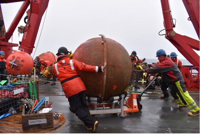
[media-caption path="/wp-content/uploads/2022/05/Picture3-1.png" link="#"]The subsurface moorings at Station Papa have various components all important for the collection of scientific data. The orange spheres provide buoyancy to keep the mooring vertical and instruments at the desired depth. Shown here is the recovery of one of these flotation spheres. Credit: Rebecca Travis ©WHOI.[/media-caption]
Station Papa 9 is the second of three nearly back-to-back recovery and deployment expeditions by OOI’s Coastal and Global Scale Node (CGSN) team this spring. The first was a Pioneer Array expedition, with two legs spanning 8-29 April. The expedition to Station Papa was next. The third after Station Papa is a nearly month-long expedition to the Irminger Sea Array, which will leave the dock in Woods Hole, MA on June 20. Said CGSN Program Manager Derek Buffitt, “Once recovered equipment is brought to shore, we immediately start to tear it down, perform inspections, download data, and start the refurbishment process. Quick turnaround times like we have had this spring, can make it challenging, but our technicians and engineers are up to the task. I am very proud of the work the CGSN team performs onshore and offshore. They are experienced professionals who you can always trust to get the job done.”
More photos and information about the Station Papa 9 expedition can be found at its expedition blog page here. OOI Station Papa data are available from using a variety of access methods described here. The NOAA/PMEL surface mooring is described here, the NOAA Noise Reference Station network is described here, and the UW Waverider is described here.
Read More
Striped Bass Link OOI Pioneer Array Locations
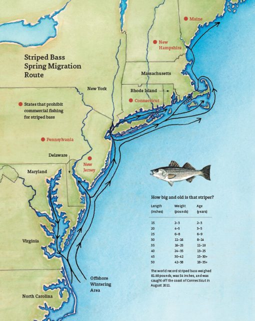
A recent article in the Martha’s Vineyard Gazette tells a fascinating tale of how fish like striped bass respond to changes in ocean conditions. The striped bass story also provides links between the current OOI Pioneer Array location on the New England Shelf (NES) and the new location in the southern Mid-Atlantic Bight (MAB).
The Northwest Atlantic has been warming due to both atmospheric and oceanographic influences (e.g., Chen et al., 2014; Gawarkiewicz et al., 2019) and the impacts can bee seen in the distribution of marine species like stripers. The stripers are typically found on the New England Shelf in the spring, with bass fishing tournaments a long-held tradition for islands like Martha’s Vineyard, Nantucket, and Cuttyhunk. But conditions are changing, and as the waters warm, the stripers appear to be moving further north. Data from the NES Pioneer Array are helping researchers and fishers understand the changes.
[media-caption path="/wp-content/uploads/2022/05/Striped-Bass-migration-map.jpg" link="#"]Striped bass spring migration route. Credit: Martha’s Vineyard Gazette and Dana Gaines Martha’s Vineyard Magazine.[/media-caption]
Stripers spawn in brackish water and spend their first few years in estuarine waters like those of the Chesapeake Bay. These waters are changing too, with earlier springs modifying spawning behavior. Understanding how environmental conditions impact the life cycle of stripers from estuary to open ocean requires knowledge of the atmosphere, continental shelf waters, and the Gulf Stream. Finally, it is necessary to investigate interactions that exchange properties between estuaries, shelf and slope sea – which will be the focus of the MAB Pioneer Array currently being planned for implementation in 2024.
References
Chen, K., G. G. Gawarkiewicz, S. J. Lentz, and J. M. Bane (2014), Diagnosing the warming of the Northeastern U.S. Coastal Ocean in 2012: A linkage between the atmospheric jet stream variability and ocean response, J. Geophys. Res. Oceans, 119, doi:10.1002/2013JC009393.
Gawarkiewicz G, Chen K, Forsyth J, Bahr F, Mercer AM, Ellertson A, Fratantoni P, Seim H, Haines S and Han L (2019), Characteristics of an Advective Marine Heatwave in the Middle Atlantic Bight in Early 2017. Front. Mar. Sci. 6:712. doi: 10.3389/fmars.2019.00712.
Schneider, P. (2022), Climate Change Clue: Follow the Stripers. Vineyard Gazette, 12 May 2022.
Read MoreR/V Oceanus Decommissioned and Celebrated
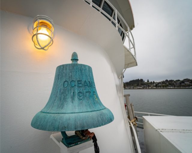
The R/V Oceanus was decommissioned last year, but its 45 years of service to the oceanographic community were celebrated at Oregon State University (OSU) at an event Friday May 6, 2022. The Coastal Endurance Array team used the Oceanus for many recovery and deployment expeditions before her retirement in 2021.
[media-caption path="/wp-content/uploads/2022/05/Picture1-copy.jpg" link="#"]The Oceanus was originally built in 1975 and began its work as a research vessel in 1976. Photo: OSU.[/media-caption]
[media-caption path="/wp-content/uploads/2022/05/graphics-OOI_AST2-DSC_5970.jpg" link="#"]R/V Oceanus departing WHOI on the deployment leg of OOI At-Sea Test 2 (AST-2) on September 22, 2011. Photo: Ken Kostel ©WHOI.[/media-caption]
Prior to its tenure at OSU, the Oceanus was in service at the Woods Hole Oceanographic Institution (WHOI) from 1976-2012. WHOI retired the ship and it was transferred to OSU in 2012. While at WHOI, the ship was used in early test deployments of equipment being evaluated for use in OOI arrays.
“The R/V Oceanus and its sister ship R/V Wecoma remain my favorite research vessels for air-sea interaction research due to their moderate size, uncluttered bows, and streamlined shapes,” said Jim Edson, Principal Investigator of the Ocean Observatories Initiative (OOI). “Research cruises on these vessels led to the development of the direct covariance systems we are using on the OOI surface moorings today.”
The Oceanus will be replaced with a new modern research vessel, the R/V Taani, which is expected to be delivered next year.
The Oceanus’ service in the Pacific is celebrated in this video produced by OSU:
[embed]https://vimeo.com/709661216[/embed]Video remembrance of Oceanus:
[embed]https://www.youtube.com/watch?v=YC2eHJa8Gbs[/embed]Video of departure:
[embed]https://www.youtube.com/watch?v=qRV1IG3rs1o[/embed]Read More
Successful Last Deployment of Pioneer Array on NE Shelf
The Pioneer 18 Array team and crew of the R/V Neil Armstrong pulled into the dock at Woods Hole, MA, on April 27, a day earlier than expected, having completed all objectives of the expedition. Their mission included the last deployment of the Pioneer Array at its current location on the New England Shelf. The Pioneer Array components now in the water will be recovered in November 2022 and redeployed in the Southern Mid-Atlantic Bight in the Spring of 2024.
The expedition consisted of two legs. On leg #1, three Coastal Surface Moorings and multiple gliders were recovered and deployed and autonomous vehicle missions were completed. On leg #2, the team deployed five Coastal Profiler Moorings. Three Coastal Surface Moorings and seven Coastal Profiler Moorings were recovered, two of which could not be recovered during an earlier expedition because of weather conditions. The recovered equipment will be taken apart, refurbished, and in some cases, reconfigured for deployment at the new location.
Weather conditions allowed for multiple deployments of a remotely operated vehicle, to help assess the condition and assist in the recovery of mooring components that could not be recovered by standard techniques (using an acoustically-triggered release). The team also conducted additional activities that ranged from water sampling adjacent to the moorings to cross-shelf CTD (conductivity, temperature, and depth) surveys in the vicinity of the moored array, and surveys using shipboard sensors. A variety of ancillary activities, accommodating eight participants from five different institutions, were also facilitated during the cruise.
Al Plueddemann, Principal Investigator of the Coastal and Global Scale Nodes (CGSN) and Chief Scientist of Pioneer 18 said, “The successful completion of this expedition again demonstrates the capabilities and experience of the CGSN team and the R/V Armstrong, and bodes well for successful operation of the Pioneer Array in its new location in the Southern Mid-Atlantic Bight.”
[media-caption path="/wp-content/uploads/2022/05/last_NES_CPM_PMUI-17-copy.jpg" link="#"]The Coastal Profiler Mooring shown here, PMUI-17, will be the last Pioneer mooring deployed on the New England Shelf. After providing data through the summer and early fall, the current array will be recovered in November of 2022 and relocated to the Southern Mid-Atlantic Bight in 2024. Credit: Jess Kozik©WHOI.[/media-caption]
The Pioneer Array was originally commissioned in 2016 as a re-locatable coastal array suitable for moderate to high wind, wave and current regimes on the continental shelf and upper slope. The new location in the Southern Mid-Atlantic Bight was decided upon after a series of workshops in 2021, co-sponsored by the National Science Foundation and the Ocean Observatories Initiative Facility Board, to gain community input on a new location that would best address pressing science questions.
Plueddemann added, “The Pioneer Array has collected a remarkable data set from the New England Shelf, which scientists will continue to use to understand frontal dynamics and related ecosystem impacts in this important and dynamic region.”
[media-caption path="/wp-content/uploads/2022/05/heads_up-copy.jpg" link="#"]When the large Coastal Surface Mooring buoys are recovered everyone pays close attention. The buoy tower spins when the hull is picked out of the water, and the deck team needs to be ready with a snap hook to clip into the circular rails on the tower top and arrest the motion. Credit: Andrew Reed ©WHOI.[/media-caption]
As the Pioneer 18 team headed home, another CGSN expedition is about to hit the water. A team of scientists and engineers is already traveling to Seward, Alaska to mobilize for another OOI expedition. On May 12, they will be aboard the R/V Sikuliaq for a 19-day expedition to the Global Station Papa Array, in the Gulf of Alaska, about 620 nautical miles offshore. This team will deploy five moorings — three for OOI and one each for the National Oceanic and Atmospheric Administration and the University of Washington. Once on site, the team will first deploy the moorings onboard, then recover those that have been in the water for a year. Upon completion, the ship will transit to the demobilization port of Seattle, Washington. Bookmark this site, and follow along on their progress.
Read MoreWHOI hosts MME Annual Meeting
The Massachusetts Marine Educators Association (MME) 46th Annual Meeting was held at Woods Hole Oceanographic Institution (WHOI) on Saturday April 30th. The event, sponsored by WHOI and Woods Hole Sea Grant, provided an opportunity for educators to get together in person, tour WHOI’s facilities, and learn about how ocean and coastal data can be used in the classroom.
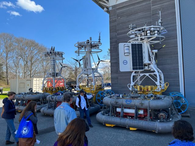
WHOI and Ocean Observatories Initiative (OOI) Engineer Sheri White gave one of the keynote addresses: “The Ocean Observatories Initiative:Collecting Long-Term Coastal and Global Time Series Data.” She followed this with a tour to a group of about 15 people of OOI’s lab and equipment testing and holding area at LOSOS and of some recovered Pioneer Array gear.
[media-caption path="/wp-content/uploads/2022/05/IMG_0498-rotated.jpg" link="#"]WHOI Engineer Sheri White showed participants recovered Pioneer Array gear. Photo: Stace Beaulieu©WHOI.[/media-caption]
WHOI Researcher Stace Beaulieu presented a workshop entitled “Wild Ocean Data: Easily Within Reach.” Her presentation, a tutorial on how to use OOI’s Data Explorer, is available online for those who missed it at https://tinyurl.com/WildOceanData.
[media-caption path="/wp-content/uploads/2022/05/IMG_0495-copy-2.jpg" link="#"]WHOI Researcher Stace Beaulieu showed how to use Data Explorer in the classroom. Photo: Annette Brickley.[/media-caption]
Rounding out the day was a presentation by Education Specialist by Annette Brickley, who presented “Is it Data? or Is it Cake?” She talked about the NES-LTER Data Jam and what students can do with NES-LTER and OOI Data.
[media-caption path="/wp-content/uploads/2022/05/IMG_0997-2-scaled.jpg" link="#"]Education Specialist Annette Brickley presented: Is it Data? Or is it cake? Photo: Stace Beaulieu ©WHOI.[/media-caption]
Read MoreRemotely Fixing and Preventing Mooring Issues
Alex Franks’s job is a big one. He is charged with fixing various issues that occur on OOI moorings, while they are hundreds and sometimes even thousands of miles away in the ocean. As an Engineer II at Woods Hole Oceanographic Institution (WHOI), Franks is intimately familiar with the mooring system controller software, which allows him to troubleshoot and fix instrumentation problems on OOI moorings, regardless of their location.
Franks has been working with electronics for over a decade and solving OOI mooring-related challenges since 2015. Many examples exist of his innovative solutions. In 2020, for example, the satellite Internet service that was being used to send data from OOI moorings to WHOI servers was no longer a viable solution. The WHOI team faced the task of either finding a replacement system, or working with the then-current system. One easily implementable solution was to move to transmitting data through OOI’s Iridium radio antennas full time. There were downsides to this solution, however. It would allow no margin of error, would consume more power, and still not be able to send data from all the instruments.
Franks figured out a better solution that would both keep costs manageable and continue to meet timely data transmission goals by modifying the Iridium file transfer portion of the mooring software to accommodate a new data transfer scheme. The new scheme used a feature of the computer program rsync, a fast and versatile file copying tool, called “diff”. Instead of using rsync to communicate with shore servers and determine the “delta” or change between the new instrument data on the mooring and the instrument data files on the WHOI server, he used one of the mooring’s onboard computers as an intermediary server to generate “diff” files against (delineating old from new data). These files were then generated and stored, and sent over the Iridium connection. Using this new configuration, Franks succeeded in sending the entire dataset of all instruments on the mooring, except one that was sent at a reduced sample rate. While transmission times can vary with weather conditions, this newly configured system sends data to the server every 20 minutes every other hour, reducing transmission times from 1440 minutes per/day to about 240 minutes per day.
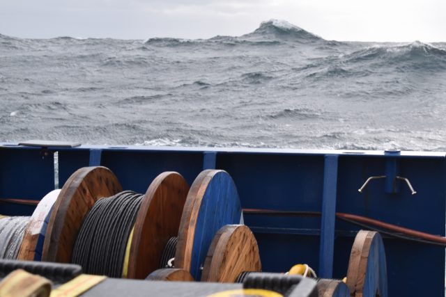
[media-caption path="/wp-content/uploads/2022/04/DSC_0639-copy.jpg" link="#"]Waves in the North Atlantic can get pretty large, which makes it hard to conduct research at sea, especially in winter. The waves and wind in the Irminger Sea also create challenges for ocean observing equipment in the water there year-round. Credit: ©WHOI.[/media-caption]
Franks also found ways to remotely manage mooring issues caused by weather and sea state by modifying software that controls wind turbines. Wind turbines play a critical role on OOI moorings, providing power to recharge the main system batteries. At the Irminger Sea Array, where the sun is absent for months at a time (the moorings also utilize solar panels), these wind turbines are critical. Prior to Franks’ software fix, human input was required to disable the turbines to prevent them from spinning while wave heights were too great. Franks modified the software used to control the spinning of the turbines to read environmental data from the buoy itself and make automated decisions in real-time that previously had to be done manually. The system now changes its configuration based on a variety of sensor inputs, which make for more immediate decisions to ensure the continued safe operations of the turbines. The software modifications not only help mitigate heavy sea damage to the turbines but saves power, as well. The software detects when the air temperature is above freezing and turns off the precipitation sensor heaters, conserving energy when possible. The software also has fail-safes in place for high or low voltage and to determine hydrogen concentration levels inside the electronics. An illustration of this software configuration is provided below.
[media-caption path="/wp-content/uploads/2022/04/Mooring-system-software-upgrade.png" link="#"] This new software configuration detects when the air temperature is above freezing and turns off the precipitation sensor heaters, and has fail-safes in place for high or low voltage and for hydrogen concentration levels inside the electronics .Credit: ©WHOI.[/media-caption]
Franks has also developed software improvements to the power system controller inside the OOI surface moorings. His work ran the gamut from disabling operational bugs in the system to reducing power consumption to fixing software errors to increase reliability. During a year-long deployment in the Irminger Sea, part of the power system controller board failed. Franks installed a software patch remotely that was able to limit the level of charge coming from wind turbines and wrote a fail-safe feature for the system to disconnect all charging sources if the voltage approached dangerous levels.
The challenges are what keeps Franks enthusiastic about his job, “I just love trying to figure out a solution and it’s particularly rewarding to be able to remotely resolve issues with equipment deployed in the open ocean.”
Read More
pH and pCO2 Time Series from the Endurance Array
Adapted and condensed by OOI from Dever et al., 2022, and Fassbender et al., 2018 doi://10.5194/essd-10-1367-2018.
The Ocean Observatories Initiative (OOI) Endurance Array makes extensive measurements of collocated physical and biogeochemical parameters throughout the water column. At the recent Ocean Sciences meeting, we reported on moored measurements from 2015 to the present off Washington and Oregon. We focused on spatial and temporal variability of pH and pCO2 and compared the measurements to published values in the region. This information was also presented in a seminar at UC, Santa Cruz on 14 Jan 2022.
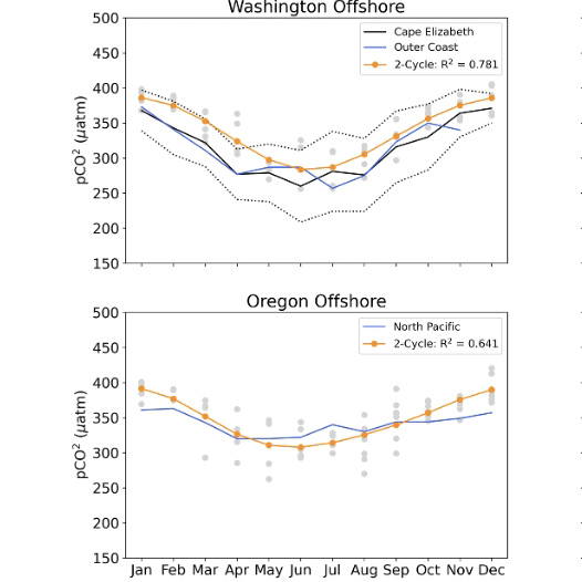
[media-caption path="/wp-content/uploads/2022/04/Endurance-highlight.png" link="#"]OOI (blue, orange) mooring seasonal cycles and monthly averages (gray) for pCO2. For context, OOI mooring cycles are plotted together with Fassbender et al. (2018) (black) regional seasonal cycles. WA moorings are compared with the Fassbender et al. Outer Coast (OC) region. OR moorings are compared with the Fassbender et al. North Pacific (NP) region.[/media-caption]
The quality-controlled biogeochemical time series are self-consistent and in line with other regional measurements. For example, pH and pCO2 have significant onshore-offshore variation and along-shelf differences north and south of the Columbia River. This variability is related to the Columbia River plume, the strength of local upwelling, and mixing with offshore waters. On a seasonal scale, pH and pCO2 is also driven by summer upwelling and winter river inputs. Variability is highest in spring and summer. pCO2 values greatly exceed atmospheric values (~400 μatm) at times in the summer (Figure above). The highest monthly pCO2 averages are seen at the Oregon shelf site.
Dever et al. (2022), pH and pC02 Time Series from the Ocean Observatories Initiative Endurance Array, CBP05, presented at Ocean Sciences Meeting 2022, Honolulu, HI (virtual), 01 Mar 2022.
Fassbender et al. (2018), Earth Syst. Sci. Data, 10, 1367–1401, 2018 https://doi.org/10.5194/essd-10-1367-2018.
Read More
Atlantic Water Influence on Glacier Retreat
Adapted and condensed by OOI from Snow et al., 2021, doi:/10.1029/2020JC016509
The warming of Atlantic Water along Greenland’s southeast coast has been considered a potential driver of glacier retreat in recent decades. In particular, changes in Atlantic Water circulation may be related to periods of more rapid glacier retreat. Further investigation requires an understanding of the regional circulation. The nearshore East Greenland Coastal Current and the Irminger Current over the continental slope are relatively well studied, but their interactions with circulation further offshore are not clear, in part due to relatively sparse observations prior to establishing the OOI Irminger Sea Array and the Overturning in the Subpolar North Atlantic Program (OSNAP).
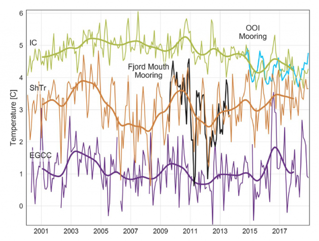
[media-caption path="/wp-content/uploads/2022/04/Pioneer-highlight.png" link="#"]Satellite-derived sea surface temperature after adjustment for the Irminger Current (IC; green), Shelf Trough (ShTr; orange), and East Greenland Coastal Current (EGCC; purple). Monthly values (thin lines) are shown for 2000-2018 with 24-month low-passed records overlain. In situ observations from the fjord mouth (290 m: Black) and OOI flanking mooring FLMA (180 m; blue) are shown for comparison.[/media-caption]
In a recent study (Snow et al., 2021) use in-situ mooring data to validate satellite SST records and then use the 19-year satellite record to investigate relationships between glacier melt and Atlantic Water variability. In order to use the satellite records for this purpose, several adjustments must be made, including accounting for cloud and sea ice contamination, eliminating seasonally-varying diurnal biases, and removing the influence of air temperature. This adjusted satellite SST can be compared to in-situ mooring data during a portion of the record. A coastal mooring near the Sermilik Fjord mouth and the OOI Irminger Sea Array provide useful records during 2009-2013 and 2014-2018, respectively (Figure 24). An interesting aspect is that the temperature record from OOI Flanking Mooring A (FLMA) is useful for this purpose even though the measurements are at 180 m depth. This is because the upper ocean is relatively homogeneous in this region, and the mixed layer is deeper than 180 m during much of the year. The authors find that the adjusted satellite SST is consistent with the in-situ records on monthly to interannual time scales (Figure above). This provided the motivation to investigate relationships between the 19 year satellite record and glacier discharge rates.
The study concludes that warmer upper ocean temperatures as far offshore as the OOI Irminger Sea Array were concurrent with increased glacier retreat in the early 2000s, in support of the idea that Atlantic Water circulation plays a role. However, they also note that this influence is not direct, because of substantial variation in how Atlantic Water is diluted as it flows across the shelf towards Sermilik Fjord. The idea that time-varying dilution of Atlantic Water governs the temperature of water reaching the glacier was not previously understood, and resolving such small-scale, time-varying processes is a challenge for models. The authors conclude that with appropriate adjustments, “[satellite] SSTs show promise in application to a wide range of polar oceanography and glaciology questions” and that the method can be generalized to other glacier outflow systems in southeast Greenland to complement relatively sparse in-situ records.
Snow, T., Straneo, F., Holte, J., Grigsby, S., Abdalati, W., & Scambos, T. (2021). More than skin deep: Sea surface temperature as a means of inferring Atlantic Water variability on the southeast Greenland continental shelf near Helheim Glacier. J. Geophys. Res: Oceans, 126, e2020JC016509. https://doi.org/10.1029/2020JC016509.
Read More