
Expeditions
RCA Embarks on a 41-day Operations and Maintenance Expedition
Watch live video here.
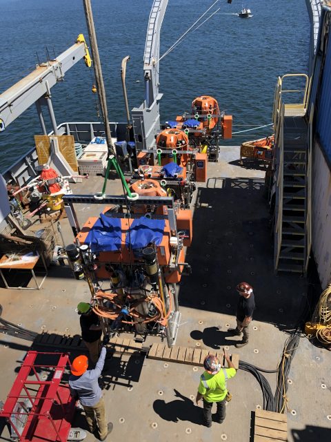
The numbers are remarkable for the Regional Cabled Array’s (RCA) Operations and Maintenance Expedition that left Newport, Oregon aboard the R/V Thomas G. Thompson on Sunday August 13. Because of its complexity and the need to move 100 different instruments, the expedition consists of four legs over 41-days. The legs are separated by ~2-3 days port call at NOAA Marine Operation Center in Newport, Oregon. A science team of 12 is conducting the scientific operations, with their work supported by an engineering team of 20 (not all onboard). The Remotely Operated Vehicle (ROV) Jason, operated by a team of 12 from the Woods Hole Oceanographic Institution, is recovering and deploying instrumentation on the RCA for the duration of the expedition.
Finally, 25 students in the University of Washington’s VISIONS Program are onboard during various legs to gain real sea-going experience and work side by side with the scientific team. Additionally, six other guest participants will be onboard, including a children’s author, engineers, and scientists.
The RCA annual expedition is always an exciting opportunity to watch real-life operations at sea. Operations will be live-streamed here. Details about the expedition, who’s involved, and what’s happening and planned can be found here. Daily updates can be found here.
[video width="608" height="1080" mp4="https://oceanobservatories.org/wp-content/uploads/2023/08/Thompson-loading.mp4"][/video] Read MoreTenth Turn of Global Station Papa Array
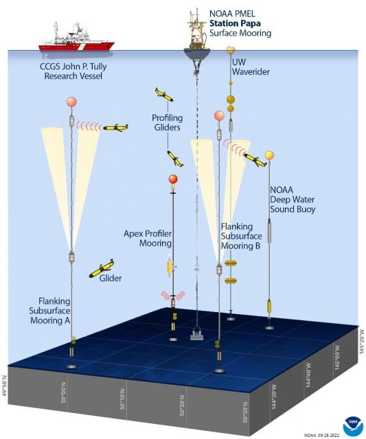
The Global Station Papa Array is in the Gulf of Alaska at a critical region of the northeast Pacific Ocean. The region is extremely vulnerable to ocean acidification, has a productive fishery, low eddy variability, and is impacted by the Pacific Decadal Oscillation, often described as the as a long-lived El Niño-like pattern of Pacific climate variability.
A team of 10 scientists and engineers from Woods Hole Oceanographic Institution (WHOI) and the University of Washington will be onboard the R/V Sikuliaq for 15 days in May to ensure that this Array continues to provide data from this important region. The team will deploy three OOI moorings, two open ocean gliders, and one profiling glider. A waverider mooring, which measures wave height and direction, will be deployed for the University of Washington. During the expedition, the team also will be conducting water sampling during recovery and deployments, and sampling while underway for instrument calibration purposes.
Located next to the NOAA Pacific Marine Environmental Laboratory (PMEL) Surface Buoy and deep-water sound buoy, the Station Papa Array is an important contributor to a cooperatively studied region. The University of Washington operates a waverider mooring near the buoys. The US Coast Guard’s Research Vessel John P. Tully regularly collects data in the region. And the Department of Fisheries in Canada operates a glider line in the region.
[media-caption path="https://oceanobservatories.org/wp-content/uploads/2023/05/CGSN_Papa-10_IRR_Presentation_2023-05-01.jpg" link="#"]The Global Station Papa Array and complementary components. Credit Sarah Battle, NOAA/PMEL, adapted from OOI.[/media-caption]This annual spring “turn” of the Array is no small undertaking. A successful turn requires months of equipment preparation and testing. After all instrumentation has been cleared to go, it is then shipped from Woods Hole Oceanographic Institution to Seward Alaska, where it is again tested as the moorings are assembled for loading onboard the Sikuliaq. Loading is complex, as well. All deck space is fully utilized and when loading is complete, 106,340 pounds of equipment will have been moved onto the ship.
“We have a good, experienced team and the Sikuliaq captain and crew couldn’t be better, “said Kris Newhall, Senior Project Manager at WHOI and Chief Scientist for Station Papa 10. “Our work in this region is really important for the data being generated are helping scientists to understand primary production, marine heat waves, and a whole lot more.”
Regular updates from the Station Papa 10 expedition will be reported here. Bookmark the page and follow along.
Read MoreRolling Seas, Followed by Blue Skies During Pioneer 15
The weather for the 15-day Pioneer 15 expedition aboard the R/V Neil Armstrong came in like a lion and left like a lamb. As the ship departed the Woods Hole dock on 28 October, the sky was gray, the air damp, and the forecast foreboding as the 10- member scientific team and the crew of the R/V Neil Armstrong headed toward the Pioneer Array, about 75 nautical miles south of Martha’s Vineyard.
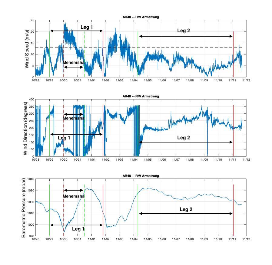
During Leg 1, the ship had some rocky days and briefly sought the protection of Menemsha Bight on the northwest side of Martha’s Vineyard as Tropical Storm Zeta passed through and brought her fury with her. Leg 2 of the journey brought with it clear skies and smooth sailing. The following shows the wind and pressure data from the ship throughout the Pioneer 15 cruise.
[media-caption path="/wp-content/uploads/2020/11/AR48_Weather-1_annotated.jpg" link="#"]Wind speed, direction, and barometric pressure from the met mast of the R/V Neil Armstrong. The green lines indicate when the ship arrived at the Array, the red lines show when it departed. The solid lines are for Leg 1 and Leg 2, and the dashed lines are the excursion to Menemsha in Leg 1. Credit: Sheri N. White (WHOI)[/media-caption]
Chief Scientist Sheri N. White said, “Despite the difficult weather, we had a very successful mission. The team recovered and deployed three coastal surface moorings and a profiler mooring, and deployed two winter coastal profiler moorings. We also were able to recover three gliders, and collect shipboard and CTD data in the vicinity of the Array. We planned on a bit of flexibility in the schedule due to the late fall departure, which always brings with it unpredictable conditions.”
The expedition was conducted in two legs because all of the moorings could not be accommodated on the ship at the same time. The Team returned to home port at the conclusion of the cruise on 11 November, when they disembarked after a month of being either in isolation or at sea away from friends and family.
The recovered moorings are now undergoing refurbishment onsite at WHOI so they will be ready for the next equipment turn in spring 2021. Next on tap for the Pioneer Array is the deployment of four gliders, Next on tap for the Pioneer Array is the deployment of four gliders, which will be done from a small vessel when the weather allows a safe transit.
Pioneer 15 in Pictures
[media-caption path="/wp-content/uploads/2020/11/DSC_0138-scaled.jpg" link="#"]The Pioneer 15 Team deploys the Central Surface Mooring on Leg 1 in dreary weather. Credit: Dee Emrich©WHOI[/media-caption]
[media-caption path="/wp-content/uploads/2020/11/DSC_0685-scaled.jpg" link="#"]The Pioneer 15 Team recovers the Inshore Surface Mooring. It had been in deployed in the water for 12 months. Credit: Dee Emrich©WHOI[/media-caption]
[media-caption path="/wp-content/uploads/2020/11/IMG_4234-scaled.jpg" link="#"]The Team dressed as oceanographers for Halloween… and deployed the Inshore Profiler Mooring in the few hours of clear skies between two storms at the Pioneer Array. Credit: Sheri N. White©WHOI[/media-caption]
[media-caption path="/wp-content/uploads/2020/11/IMG_4244-scaled.jpg" link="#"]The R/V Neil Armstrong left the WHOI dock on Leg 2 of the Pioneer 15 expedition, with the Central Surface Mooring in position for deployment. Credit: Sheri N. White©WHOI[/media-caption]
[media-caption path="/wp-content/uploads/2020/11/IMG_4245-scaled.jpg" link="#"]The Offshore Surface Mooring is ready for deployment on the stern of the R/V Neil Armstrong on Leg 2. Credit: Dee Emrich©WHOI[/media-caption]
[media-caption path="/wp-content/uploads/2020/11/IMG_4245-scaled.jpg" link="#"]Beautiful weather on Leg 2 made recovering the large surface moorings a bit easier. The surface moorings were deployed for 12 months, rather than six, due to the COVID pandemic. Credit: Jennifer Batryn©WHOI[/media-caption]
[media-caption path="/wp-content/uploads/2020/11/PMOU-16_deploy.jpg" link="#"]This is what a Profiler Mooring looks like during deployment. Profiler Moorings collect data from the entire water column using a McLane Moored Profiler, which crawls up and down the mooring line. Credit: Sheri N. White©WHOI[/media-caption]
[media-caption path="/wp-content/uploads/2020/11/ISSM_Biofouling.jpg" link="#"]This is some of the biology that has taken up residence on the Inshore Surface Mooring during its year-long stay on the Atlantic continental shelf. Credit: Dee Emrich©WHOI[/media-caption]
Read More
Mission Complete: 23 Days at Sea
By Darlene Trew Crist and Debbie Kelley
23 days at sea.1200 miles of transit. 44 ROV Jason Dives. Over 80,000 lbs of equipment mobilized. Turned, deployed or recovered 225 pieces of infrastructure on the seafloor and in the water column. More than 500 hours of continuous livestreaming video from ship to shore through a satellite 22,000 miles overhead, and daily updates of cruise activities.
These numbers provide only a glimpse of what was accomplished by a team of scientists and engineers from the University of Washington (UW), pilots of the ROV Jason from Woods Hole Oceanographic Institution, and the captain and the crew of the R/V Thomas G. Thompson, during a nearly month-long expedition in the northeast Pacific Ocean to maintain OOI’s Regional Cabled Array (RCA), operated and maintained by UW. After a mandatory two-week quarantine, the scientific party departed aboard the R/V Thompson from Newport, Oregon on 1 August to begin the journey to replace and install equipment on the array. The ship returned to Newport on 13 August to offload the recovered equipment and load a new supply for the second Leg, which left on 15 August, finally returning to port on 26 August.
Funded by the National Science Foundation (NSF), the cruise was highly complex, involving a diverse array of ~109 Core instruments, three junction boxes, two Benthic Experiment Platforms, six instrumented pods on the Shallow Profiler Moorings, which were recovered and installed, and three Deep Profiler vehicles, which were turned. In addition, six instruments conducting scientific experiments for principal investigators external to OOI were recovered, one was installed and another turned.
While the overall mission was clear, the cruise plan remained flexible to allow the Chief Scientists to modify operations, as needed, depending upon weather conditions. The expedition traveled to all of the RCA sites — Slope Base, Oregon Offshore, Oregon Shelf, Southern Hydrate Ridge, and Axial Base and Axial Caldera, with multiple 22-hour transits to Axial Seamount.
[media-caption type="image" class="external" path="https://oceanobservatories.org/wp-content/uploads/2020/09/Regional-Cabled-Array.-.jpg" alt="Regional Cabled Array" link="#"]Location of RCA infrastructure showing installed backbone cable (solid lines), extension opportunities (dashed lines) Primary Nodes (red boxes), cabled moorings (green dots), and Endurance uncabled moorings (yellow dots). Credit: University of Washington.[/media-caption]All Objectives Completed on Leg One
All instrument and platform installations scheduled for Leg 1 were completed by mid-day on 12 August during 26 dives. Six instrumented platforms on the Shallow Profiler Moorings and three instrumented Deep Profiler vehicles were turned, two junction boxes and over 80 instruments recovered and reinstalled.
Taking advantage of the good weather and the early completion of anticipated tasks, the RCA team transited to the Endurance Shelf site (80 meters), where they recovered several cabled platforms and instruments that were planned for Leg 2 of the expedition. Again, taking advantage of ideal visibility at the seafloor there, the RCA team performed three Jason dives, successfully recovering the Zooplankton Sonar, the Benthic Experiment Package (BEP), and a digital still camera.
After the completion of these dives, the R/V Thomas G.Thompson headed back to shore. The ship arrived at the NOAA Marine Operations Center-Pacific dock in Newport, Oregon on 13 August and began mobilization/demobilization for the changeover from Leg 1 to Leg 2 of the cruise.
[media-caption type="image" class="external" path="https://oceanobservatories.org/wp-content/uploads/2020/09/Combined-picture-RCA.jpg" alt="Combined picture" link="#"]Deploying the new Deep Profiler vehicle at Slope Base on 11 August (left) Credit: M. Elend, University of Washington, V20.; Recovering the Benthic Experiment Package (BEP) at the Endurance Shelf site (right): Credit: UW/NSF-OOI/WHOI.V20.[/media-caption] [media-caption type="image" class="external" path="https://oceanobservatories.org/wp-content/uploads/2020/09/Combined-2.jpg" alt="Combined 2" link="#"]R/V Thomas G. Thompson, Leg 1 Demobilization / Leg 2 Mobilization of two BEPs, a Zooplankton sonar platform, and platforms to be installed at Axial Seamount Credit: University of Washington, V20.[/media-caption]Weather Challenges on Leg Two
The ship departed from Newport again on 15 August and headed to the Endurance Array Oregon Shelf site to resume maintenance operations. There, the team deployed the cabled Zooplankton Sonar, however, installation of the BEP, which weighs over 3,000 lbs and is latched underneath Jason for installation and recovery, was postponed due to large swells.
The ship next transited over 300 miles offshore to Axial Seamount to complete the maintenance activities there. When the Thompson arrived at Axial, it successfully turned a secondary node at the Eastern Caldera site that provides power and bandwidth to a geophysical suite of instruments and now hosts a new CTD funded by NSF to Dr. W. Chadwick (one of three instruments for installation on the RCA as part of this award). It was a notable event because the junction box had been deployed on 22 July 2013 and had spent the last 2,583 days or 7.1 years in 1516 meters of water within Axial Caldera!
For the next eight days, cruise operations proceeded smoothly with intermittent weather delays. Even though weather was not completely cooperative, the team was able to complete a total of 14 dives during which they turned a BEP, two digital still cameras, two uncabled seafloor instruments, and a CTD. They also recovered three cabled instruments and an uncabled instrumented platform for principal investigators conducting research at Southern Hydrate Ridge. One dive was dedicated to an inspection and troubleshooting of Primary Node PN1B, which was offline.
Later in the cruise, weather put onboard activities on hold, however, a cohort of enthusiastic students onshore (due to COVID) virtually ‘visited’ the ship and Jason operations van as part of the NSF-funded STEMSEAS program, which provides at-sea experiences for undergraduates. The students had the opportunity to interact with Chief Scientist Brendan Philip, who completed his oceanography undergraduate and masters’ degree at the University of Washington, as well as a visit with two UW and Queens College undergraduate students sailing onboard as science aides as part of the UW VISIONS experiential learning program. They were also introduced to RCA engineers and members of the Jason team inside the control van.
[media-caption type="image" class="external" path="https://oceanobservatories.org/wp-content/uploads/2020/09/Katie_Steve_sm.Newport_20200815_111023_L2_start-copy-2-scaled.jpg" alt="Katie_Steve" link="#"]K. Gonzalez, UW Oceanography undergraduate, and S. Karaduzovic, Queens College undergraduate, gaze out into the NE Pacific as the R/V Thomas G. Thompson sails through the Yaquina Bay channel on its way to begin Leg 2 of the RCA expedition. Credit. M. Elend, University of Washington. V20.[/media-caption] [media-caption type="image" class="external" path="https://oceanobservatories.org/wp-content/uploads/2020/09/J1267_20200809_155656_THSPHA301_deploy-copy.jpg" alt="Screen" link="#"]Video, sonar, and navigation panels inside the ROV Jason control van as the team works nearly a mile beneath the oceans’ surface at the International District Hydrothermal Field atop Axial Seamount. Credit: University of Washington. V20.[/media-caption]With lessening swell heights, the team completed RCA maintenance tasks at Southern Hydrate Ridge. Additional efforts were focused on the recovery of a cabled multi-beam sonar and a 4K camera funded by Germany to Drs. Y. Marcon and G. Bohrmann, Bremen University, to quantify methane flux and turning of a CTD. In addition, a methane microbial fuel cell platform was recovered as part of an Office of Naval Research (ONR)-funded project to Dr. C. Reimers (Oregon State University)—sailing as a member of the Leg 2 shipboard party. Upon completion of instrumentation work at Southern Hydrate Ridge, the Thompson transited back to the Endurance Array Oregon Shelf site to complete the remaining maintenance task, the deployment of the cabled BEP.
During the latter part of the cruise, weather again impacted what the team was able to do, but the science team continued to improvise to utilize ship time as efficiently as possible. For example, when winds (>20 knots) and large swells in the Shelf Area prevented the team from deploying the final (heavy) BEP, Dr. Reimers used some of her remaining ONR-supported at-sea time to conduct a Jason dive in the region of the West Coast Rockfish Conservation Area to survey fish, invertebrates, seeps, and trawl marks along a downslope transect. These data will be useful for collaborative work between Oregon State University and the Oregon Department of Fish and Wildlife scientists in decision-making about the reopening of the region in 2020, after 19 years of being closed to bottom trawling.
When the weather cleared, the team performed its final maintenance task of the cruise. They deployed the cabled Shelf BEP in 80 meters of water, after which the ship headed back to Newport to reunite with friends and family after six weeks away. The expedition ended having met all objectives, in spite of the weather.
Unique Views of the Seafloor
The RCA expedition literally offered a “bird’s eye view” of seafloor life. Below is a collection of some of the activities conducted and life witnessed on the seafloor.
Crab-infested Primary Node
[media-caption type="image" class="external" path="https://oceanobservatories.org/wp-content/uploads/2020/09/News_Crabs_PN1B-use-sulis2_20200818202445--scaled.jpg" alt="News_Crabs" link="#"]The ROVJason inspects Primary Node PN1B. These 12,000 lb nodes and primary backbone cable were built and installed in 2014 through an award to L3MariPro. This large seafloor substation converts 10,000 volts to 374 volts, and 10 Gb/s bandwidth to be distributed to cabled platforms and instruments. Here, extension cables plugged inside the node with wet-mate connectors provide power and bandwidth to Southern Hydrate Ridge, and upstream to the Oregon Offshore and Shelf sites. Credit: UW/NSF-OOI/WHOI. V20.[/media-caption]Octopus Abound
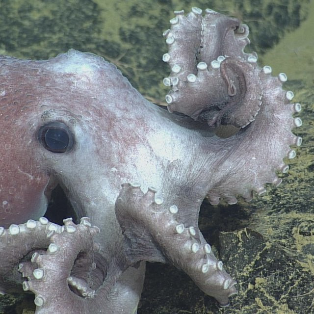
[media-caption type="image" class="external" path="https://oceanobservatories.org/wp-content/uploads/2020/09/Octopus-on-the-seafloor.jpg" alt="Octopus on the seafloor" link="#"]Octopus on the seafloor at Endurance Array Oregon Offshore Site. Credit: UW/NSF-OOI/WHOI. V20.[/media-caption]Islands of Sea Life
[media-caption type="image" class="external" path="https://oceanobservatories.org/wp-content/uploads/2020/09/news_SHllow-Profier_Offshore_20200803_133613180.framegrab03-copy.jpg" alt="Shallow_Profiler" link="#"]The ROV Jason installs a refurbished instrumented platform onto the Shallow Profiler Mooring at the cabled Oregon Offshore site. The platform hosts a zooplankton sonar, and instruments that measure pH, dissolved CO2, salinity, temperature, and dissolved oxygen. The 12 ft-across large mooring platforms at 200 m depth stay in the water for several years and become islands inhabited by a wealth of sea life. Credit: UW/NSF-OOI/WHOI.V20.[/media-caption]Big Red
[media-caption type="image" class="external" path="https://oceanobservatories.org/wp-content/uploads/2020/09/Big_Red_Jelly_sm.sulis2_20200817205124-copy-2-scaled.jpg" alt="Big Red Jellyfish" link="#"]A “Big Red” jellyfish swam past the ROV Jason 68 miles offshore of Oregon. Credit; UW/NSF-OOI/WHOI.V20.[/media-caption]Methane Seeps
[media-caption type="image" class="external" path="https://oceanobservatories.org/wp-content/uploads/2020/09/News_Abundant-Life-SHR_good_sulis2_20200826014741-copy-2-scaled.jpg" alt="Abundant_Sea_Life" link="#"]The Regional Cabled Array team always enjoys dives to the methane seep site at the Southern Hydrate Ridge. It is rich in animals — e.g. red striped rockfish, lavender hagfish, crabs, spotted sole — that thrive among the carbonate blocks and adjacent to the seeps where methane streams from the seafloor. Credit: UW/NSF-OOI/WHOI.V20.[/media-caption]Axial Seamount Summit
[media-caption type="image" class="external" path="https://oceanobservatories.org/wp-content/uploads/2020/09/News_use_J2-1277_Great-Crab-collapse_sulis2_20200817132525-copy-scaled.jpg" alt="Spider Crab" link="#"]A spider crab explores a collapsed, frozen lava lake at the summit of Axial Seamount, an active underwater volcano 4970 ft beneath the oceans’ surface, which is poised to soon erupt. Credit: UW/NSF-OOI/WHOI.V20.[/media-caption]
Read More
Live Video from Regional Cabled Array Expedition
Don’t miss this rare opportunity to participate in a research cruise from aboard the ship and below the surface. Live video is being broadcast from the Regional Cabled Array’s eighth Operations and Maintenance expedition aboard the R/V Thomas G. Thompson. It is really an extraordinary way to watch first-hand the complexity of the operation involved in keeping a network of 900 kilometers of electro-optical cables supplying unprecedented power, bandwidth (10 Gigabit Ethernet, and two-way communication to scientific sensors on the seafloor and throughout the water column, so data are continuously collected and research conducted. Bookmark these links and tune in often!
Streaming live video from the ship and from the ROV ROPOS.
Credit: NSF-OOI/UW/CSSF.[/caption]
Read More
Live Video from Regional Cabled Array Expedition
For the month of August, you can be a scientist aboard the R/V Thomas G. Thompson Regional Cabled Array expedition and explore the ocean floor and biologically-rich waters of the northeastern Pacific Ocean in real-time. A livestream is being broadcast of onboard activities and from the ROV, as it recovers and deploys instrumentation to maintain the Regional Cabled Array. Bookmark this livestream link and during August you can experience life and science at sea.
Please note: The livestream video is transmitted from the ship to a satellite, then to shore. Occasionally, the land-based down-link system goes down and depending on the ship’s heading, there may be an intermittent pause in the satellite connection. If the screen is blank or you see an error code, please check back soon as the connection should refresh shortly.
Read More
Science Team Heads to Blustery Irminger Sea
Ten scientists from Woods Hole Oceanographic Institution (WHOI) will board the R/V Neil Armstrong on 8 August 2020 for about a month-long expedition to OOI’s Irminger Sea Array. The journey includes an eight-day transit to reach the array, where they will recover and replace ocean observing equipment that has ridden out arduous conditions in a region known for intense winter wind events (peak speeds of 50-55 knots).
[media-caption path ="https://oceanobservatories.org/wp-content/uploads/2020/08/Irminger-Deck-Plan-small-scaled.jpg" link="#" title="Iminger Deck] Aerial view of the R/VNeil Armstrong deck with equipment loaded for an OOI Irminger Sea Array service cruise. Credit: Drone footage by James Kuo © Woods Hole Oceanographic Institution[/media-caption]Iceland is separated from the east coast of Greenland by the Denmark Strait, roughly a distance of some 250 miles. The Irminger Sea is south of the strait, stretching from Iceland down to the latitude of Cape Farewell at Greenland’s southern tip. This region is important to the Atlantic Ocean circulation and sensitive to global climate change.
Supported by wind power and solar cells, the Irminger Sea Array consists of moorings that serve as home for sensors that measure air-sea fluxes of heat, moisture and momentum, and physical, biological and chemical properties throughout the water column. The observations of the moorings are enhanced by open-ocean gliders that sample within and around the triangular array. The subsurface mooring data is also collected by the gliders via acoustic modem. The gliders then relay the collected data, glider sampling and mooring data, to shore via satellite telemetry each time they surface. Gliders also sample the upper water column near the Apex Profiler Mooring to complement the moored profiler data and extend coverage to the air-sea interface.
This month-long expedition is the seventh time the OOI team has traveled to the array, specifically to replace and repair equipment that is vital to maintaining a continuous flow of data from this important site.
“This is a difficult region to sustain surface observations, yet such observations are critical to improving our understanding of air-sea exchanges and deep convection that drives the Atlantic overturning circulation” said Al Plueddemann, project scientist for the OOI Coastal and Global Scale Nodes (CGSN).
WHOI Research Scientist Sebastien Bigorre will serve as the chief scientist for the expedition.
COVID Complications
The scientific party went into a 14-day quarantine on 21 July to ensure that everyone could safely board the ship. They were tested for COVID-19 prior to quarantine and will be tested again prior to departure. Masks and social distancing will be practiced onboard until another two-week period of health is achieved. At that point, mask wearing may be loosened as the scientific team and crew members will, in effect, be their own social bubble as they live, work, and share the space of the 238 foot-long vessel.
[media-caption path="https://oceanobservatories.org/wp-content/uploads/2020/08/DSC_0016_allison-scaled.jpeg" link="#" title="crew deploys a near surface instrument frame to the array"]During a past expedition to the Irminger Sea Array, the crew deploys a near surface instrument frame to the array. Credit: Alison Heater © Woods Hole Oceanographic Institution[/media-caption]Explained Derek Buffitt, program manager for the Coastal and Global Scale Nodes, operated from Woods Hole Oceanographic Institution, which includes oversight of the Irminger Sea Array, “COVID-19 created plenty of new logistical challenges for an expedition of this length and distance. We had to address contingencies such as what to do if someone presented COVID symptoms while at sea. WHOI’s marine operations office, working with agents and government representatives, confirmed health and safety protocols within the foreign ports along the planned vessel track. This was to ensure our personnel could receive the care needed in an emergency and in a timely manner.”
Such contingencies were necessary steps, in addition to many months of preparation, to ensure the equipment to be deployed is ready, tested, and packaged for transporting to the ship.
Watch this space, and social media, as we follow along on this important expedition.
Read MoreTeam Headed to Pioneer Array
After ten weeks of preparation, two weeks of isolation, documentation of negative COVID-19 tests, temperatures taken, and personal protective gear in place, nine science team members from Woods Hole Oceanographic Institution (WHOI) will depart on the R/V Neil Armstrong from Woods Hole, MA on Sunday 7 June 2020 for an 11-day expedition to service the Pioneer Array, a collection of ocean observing equipment off the New England coast, about 75 nautical miles south of Martha’s Vineyard.
The Pioneer mission is the first science expedition to leave Woods Hole following a “pause” in research expeditions imposed in March by UNOLS (University-National Oceanographic Laboratory System). UNOLS coordinates the U.S. academic research fleet ship schedules and has established guidelines for COVID prevention and mitigation aboard these ships. The journey aboard the R/V Neil Armstrong is the second UNOLS science expedition to leave port with new stringent COVID-prevention protocols in place.
“We’ve worked extremely hard to implement measures that will help ensure the safety and health of our scientific party and crew members aboard the R/V Neil Armstrong,” said Al Plueddemann, chief scientist for the Pioneer Array expedition and a research scientist at WHOI. “It’s been an extensive planning and re-planning effort as our procedures had to adapt to changing circumstances.”
“We’ve had to reduce our scientific team significantly to ensure there is enough social distancing room aboard the ship, and condense the work into one cruise leg instead of two, which forced us to scale back the scientific mission, as well. But with the extensive precautionary measures in place, we are able to provide much needed service to the array, while also ensuring the cruise is sufficiently low risk to all personnel involved.”
The Pioneer Array is a collection of long-term oceanographic observing equipment that provides continuous ocean measurements over a period of years. The data collected are sent via satellite to a network server on shore for use by scientists, educators, and others. The data are available for everyone to use in as near real-time as possible. These long time-series data are helping to advance ocean research, understanding of ocean processes, and the changing ocean. The equipment requires regular maintenance to ensure that it can continually collect and disseminate biological, physical, and chemical ocean observations for the the oceanographic community and others who have come to rely on it. The Pioneer Array is one of five ocean observing arrays collecting real-time ocean data as part of the National Science Foundation funded Ocean Observatories Initiative.
Extensive precautionary measures were necessary to enable the ship and its passengers to conduct the science mission safely during the COVID-19 pandemic.
“Preparations began with trying to figure out the appropriate length and circumstances under which the scientific party and crew members could quarantine prior to heading out to sea, then evolved into gaining access to COVID-19 testing and labs to process the results, determining how to house the scientific party while in quarantine and onboard the vessel, and defining social distancing and protective gear that would be needed while at sea,” said Derek Buffitt, program manager for the Coastal Global Scale Node arrays, which includes the Pioneer Array.
Once such decisions were made, other practical considerations were tackled, such as how to:
- store used personal protective gear while at sea for onshore disposal,
- arrange bunks to minimize shared space,
- feed passengers and maintain social distances in shared common spaces,
- maintain the operational safety of the smaller science party,
- prioritize the scientific objectives to ensure the most effective use of the ship time, and
- respond if someone presented COVID-19 symptoms while at sea.
“The Pioneer expedition departure on Sunday will represent the successful culmination of preparations for the new normal of conducting research at sea during a pandemic,” added Plueddemann.
Read More