
GI03FLMB
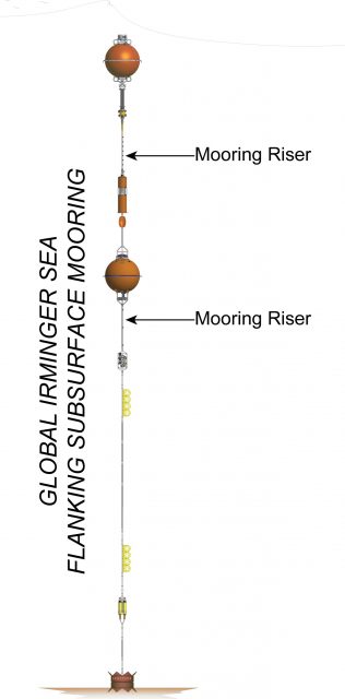
The Global Irminger Sea array has two identical Flanking Moorings that make up the equidistant sides of a triangle of Moorings (20 km) from the co-located Profiler and Surface Moorings. They are located in 2,800 meters of water southeast of Greenland in the North Atlantic.
Platform DOI and Citation Guidance
OOI assigns Digital Object Identifiers (DOIs) at the platform or site level. The DOI for the Global Irminger Sea Flanking Subsurface Mooring B is 10.58046/OOI-GI03FLMB.
The minimum recommended citation for this platform is:
NSF Ocean Observatories Initiative. (2014). Global Irminger Sea Flanking Subsurface Mooring B, DOI: 10.58046/OOI-GI03FLMB.
This follows the format NSF Ocean Observatories Initiative. (Year Published). Platform title, DOI: Platform DOI, where Year Published is the year OOI data collection began at the site.
We encourage data users to incorporate full citations when referencing OOI data in order to support FAIR data principles and data traceability. OOI also provides further guidance on citations, including information on adding specific data products and data access points to citations.
Data Access
The following links provide data access via Data Explorer or other methods:
- Direct access to the data on this platform and its subcomponents
- General access to OOI data using a variety of methods
Platform Description
The Global Irminger Sea array has two identical Flanking Moorings that make up the equidistant sides of a triangle of Moorings (20 km) from the co-located Profiler and Surface Moorings. They are located in 2,800 meters of water southeast of Greenland in the North Atlantic. The triangular configuration moorings provide unique spatial array through which instruments fixed to moorings continuously collect data through time and gliders sample the area between the moorings. The Irminger Sea site is one of four high latitude open ocean locations in the OOI that provide observations to gain better insight into global ocean circulation and climate.
Like other Flanking Subsurface Moorings, the Irminger Sea Flanking Subsurface Moorings contain instruments fixed at specific depths along the mooring riser throughout the water column to a depth of 2,600 meters. The flotation buoy for these subsurface moorings is located 30 meters below the sea surface. As they have no surface expression, these moorings communicate and send data to shore via an acoustic link to nearby gliders.
Read MoreGP03FLMB
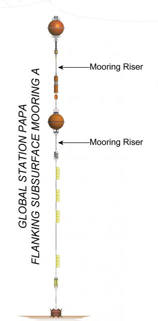
The Station Papa array has two identical Flanking Moorings that make up the equidistant sides of a triangle of Moorings (40 km) from the co-located Profiler and Surface Moorings. They are located in 4,250 meters in the Gulf of Alaska in the NE Pacific.
Platform DOI and Citation Guidance
OOI assigns Digital Object Identifiers (DOIs) at the platform or site level. The DOI for the Global Station Papa Flanking Subsurface Mooring B is 10.58046/OOI-GP03FLMB.
The minimum recommended citation for this platform is:
NSF Ocean Observatories Initiative. (2013). Global Station Papa Flanking Subsurface Mooring B, DOI: 10.58046/OOI-GP03FLMB.
This follows the format NSF Ocean Observatories Initiative. (Year Published). Platform Title, DOI: Platform DOI, where Year Published is the year OOI data collection began at the site.
We encourage data users to incorporate full citations when referencing OOI data in order to support FAIR data principles and data traceability. OOI also provides further guidance on citations, including information on adding specific data products and data access points to citations.
Data Access
The following links provide data access via Data Explorer or other methods:
- Direct access to the data on this platform and its subcomponents
- General access to OOI data using a variety of methods
Platform Description
The Station Papa array has two identical Flanking Moorings that make up the equidistant sides of a triangle of Moorings (40 km) from the co-located Profiler and Surface Moorings. They are located in 4,250 meters in the Gulf of Alaska in the NE Pacific. The triangular configuration moorings provide unique spatial array through which instruments fixed to moorings continuously collect data through time and gliders sample the area between the moorings. The Station Papa site is one of four high latitude open ocean locations in the OOI that provide observations to gain better insight into global ocean circulation and climate.
Like other Flanking Subsurface Moorings, the Station Papa Flanking Subsurface Moorings contain instruments fixed at specific depths along the mooring riser throughout the water column to a depth of 1,500 meters. The flotation buoy for these subsurface moorings is located 30 meters below the sea surface. As they have no surface expression, these moorings communicate and send data to shore via an acoustic link to nearby gliders.
Read MoreRS01SUM1
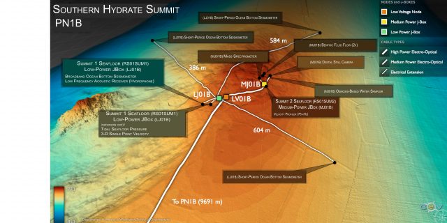
The Southern Hydrate Summit 1 Seafloor study site, situated on the continental slope off the coast of Oregon at a water depth of ~ 775 m, hosts abundant deposits of methane ice (methane hydrates) that are buried beneath, and sometime exposed at the seafloor.
Platform DOI and Citation Guidance
OOI assigns Digital Object Identifiers (DOIs) at the platform level. The DOI for the Oregon Margin Southern Hydrate Summit 1 Seafloor is 10.58046/OOI-RS01SUM1.
The minimum recommended citation for this platform is:
NSF Ocean Observatories Initiative. (2014). Oregon Margin Southern Hydrate Summit 1 Seafloor, DOI: 10.58046/OOI-RS01SUM1.
This follows the format NSF Ocean Observatories Initiative. (Year Published). Platform title, DOI: Platform DOI, where Year Published is the year OOI data collection began at the platform.
We encourage data users to incorporate full citations when referencing OOI data in order to support FAIR data principles and data traceability. OOI also provides further guidance on citations, including information on adding specific data products and data access points to citations.
Data Access
The following links provide data access via Data Explorer or other methods:
- Direct access to the data on this platform and its subcomponents
- General access to OOI data using a variety of methods
Platform Description
The Southern Hydrate Summit 1 Seafloor study site, situated on the continental slope off the coast of Oregon at a water depth of ~ 775 m, hosts abundant deposits of methane ice (methane hydrates) that are buried beneath, and sometime exposed at the seafloor. The deposits vent methane-rich fluids and bubbles that escape through seeps on the ocean bottom. At Southern Hydrate Ridge plumes of bubbles rise several hundred meters above the seafloor. Dense and fascinating communities of microbes and animals with symbiotic microbes in their guts are fueled by these escaping gases. These seeps provide a unique opportunity to study ocean chemistry, quantifying chemical fluxes from the seafloor and the impacts of methane release on overlying seawater and biota.
Methane is a powerful greenhouse gas and, therefore, quantifying the flux of methane from the seafloor into the hydrosphere is critical to understanding carbon-cycle dynamics and the impacts of global warming on methane release, particularly in the context of the hydrates response to seismic events.
This Low-Power JBox (LJ01B) rests on the seafloor and contains geophysical and near seafloor water column instrumentation, and is attached to a fiber-optic cable. Instrumentation hosted on the JBox is largely geophysical in nature, hosting both short-period and broadband seismometers. The fiber-optic cable provides the JBox with significant power and 1 Gb communication bandwidth for two-way communication to instruments for their operation and transmission of data to shore. This JBox is also co-located with a Medium-Power JBox that collects a complementary suite of seafloor and water column measurements.
Read MoreRS01SUM2
The Southern Hydrate Summit 2 Seafloor study site, situated on the continental slope off the coast of Oregon at a water depth of ~ 775 m, hosts abundant deposits of methane ice (methane hydrates) that are buried beneath, and sometime exposed at the seafloor.
Platform DOI and Citation Guidance
OOI assigns Digital Object Identifiers (DOIs) at the platform level. The DOI for the Oregon Margin Southern Hydrate Summit 2 Seafloor is 10.58046/OOI-RS01SUM2.
The minimum recommended citation for this platform is:
NSF Ocean Observatories Initiative. (2014). Oregon Margin Southern Hydrate Summit 2 Seafloor, DOI: 10.58046/OOI-RS01SUM2.
This follows the format NSF Ocean Observatories Initiative. (Year Published). Platform title, DOI: Platform DOI, where Year Published is the year OOI data collection began at the platform.
We encourage data users to incorporate full citations when referencing OOI data in order to support FAIR data principles and data traceability. OOI also provides further guidance on citations, including information on adding specific data products and data access points to citations.
Data Access
The following links provide data access via Data Explorer or other methods:
- Direct access to the data on this platform and its subcomponents
- General access to OOI data using a variety of methods
Platform Description
The Southern Hydrate Summit 2 Seafloor study site, situated on the continental slope off the coast of Oregon at a water depth of ~ 775 m, hosts abundant deposits of methane ice (methane hydrates) that are buried beneath, and sometime exposed at the seafloor. The deposits vent methane-rich fluids and bubbles that escape through seeps on the ocean bottom. At Southern Hydrate Ridge plumes of bubbles rise several hundred meters above the seafloor. Dense and fascinating communities of microbes and animals with symbiotic microbes in their guts are fueled by these escaping gases. These seeps provide a unique opportunity to study ocean chemistry, quantifying chemical fluxes from the seafloor and the impacts of methane release on overlying seawater and biota.
Methane is a powerful greenhouse gas and, therefore, quantifying the flux of methane from the seafloor into the hydrosphere is critical to understanding carbon-cycle dynamics and the impacts of global warming on methane release, particularly in the context of the hydrates response to seismic events.
This Medium-Power JBox (MJ01B), connected to a fiber optic cable, rests on the seafloor adjacent to a highly active methane seep called Einstein’s Grotto. Instrumentation at this site is designed to monitor chemistry of the seep, image the seep and associated biota in detail, and image the bubble plume as it rises several hundred meters above the seafloor. The fiber-optic cable provides the JBox with significant power and 1 Gb communication bandwidth for two-way communication to instruments for their operation and transmission of data to shore. This JBox is also co-located with a Low-Power JBox that collects a complementary suite of seafloor and near seafloor water column measurements.
Read MoreRS03ASHS
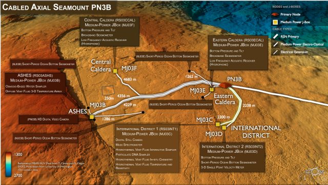
The ASHES hydrothermal field is located near the base of the western caldera wall of Axial Seamount at a water depth of 1552 m. It hosts numerous active hydrothermal sulfide chimneys, myriad lower temperature diffuse flow sites, and abundant vent biota.
Platform DOI and Citation Guidance
OOI assigns Digital Object Identifiers (DOIs) at the platform level. The DOI for the Axial Seamount ASHES Vent Field is 10.58046/OOI-RS03ASHS.
The minimum recommended citation for this platform is:
NSF Ocean Observatories Initiative. (2014). Axial Seamount ASHES Vent Field, DOI: 10.58046/OOI-RS03ASHS.
This follows the format NSF Ocean Observatories Initiative. (Year Published). Platform title, DOI: Platform DOI, where Year Published is the year OOI data collection began at the platform.
We encourage data users to incorporate full citations when referencing OOI data in order to support FAIR data principles and data traceability. OOI also provides further guidance on citations, including information on adding specific data products and data access points to citations.
Data Access
The following links provide data access via Data Explorer or other methods:
- Direct access to the data on this platform and its subcomponents
- General access to OOI data using a variety of methods
Platform Description
The ASHES hydrothermal field is located near the base of the western caldera wall of Axial Seamount at a water depth of 1552 m. It hosts numerous active hydrothermal sulfide chimneys, myriad lower temperature diffuse flow sites, and abundant vent biota. The focused study area is at the ~ 4 m tall actively venting sulfide chimney called “Mushroom” and a diffuse flow site adjacent to the base of the chimney. Instrumentation at this site is focused on understanding linkages between local and far-field seismic events on fluid chemistry and temperature, chimney evolution, and impacts on vent biota.
Seafloor instruments at the ASHES site are attached to a Medium-Power J-Box (MJ03B) through a series of extension cables. An ~ 4 km long extension cable from Primary Node PN03B provides the JBox with significant power (375 v) and bandwidth (1 Gbs) to operate the instruments and transmit data to shore. In addition to geophysical and temperature monitoring instrumentation attached the MJ03B JBox, the site also hosts a high definition video camera, linked to shore via a separate fiber optic cable that provides 10 Gb bandwidth from PN03B. This allows full resolution video to be transferred in real-time to shore, along with communications for pan and tilt capabilities, as well as lights.
Read MoreRS03AXBS
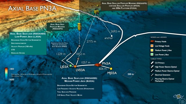
The Axial Base Seafloor platform is located near the base of the Axial Seamount at the far western edge of the Juan de Fuca tectonic plate, at ~2,600 meters water deep. The site contains a Medium-Power JBox (MJ03A) and a Low-Power JBox (LJ03A).
Platform DOI and Citation Guidance
OOI assigns Digital Object Identifiers (DOIs) at the platform level. The DOI for the Axial Seamount Base Seafloor is 10.58046/OOI-RS03AXBS.
The minimum recommended citation for this platform is:
NSF Ocean Observatories Initiative. (2014). Axial Seamount Base Seafloor, DOI: 10.58046/OOI-RS03AXBS.
This follows the format NSF Ocean Observatories Initiative. (Year Published). Platform title, DOI: Platform DOI, where Year Published is the year OOI data collection began at the platform.
We encourage data users to incorporate full citations when referencing OOI data in order to support FAIR data principles and data traceability. OOI also provides further guidance on citations, including information on adding specific data products and data access points to citations.
Data Access
The following links provide data access via Data Explorer or other methods:
- Direct access to the data on this platform and its subcomponents
- General access to OOI data using a variety of methods
Platform Description
The Axial Base Seafloor site is located near the base of the Axial Seamount at the far western edge of the Juan de Fuca tectonic plate, at ~2,600 meters water deep. The site contains a Medium-Power JBox (MJ03A) and a Low-Power JBox (LJ03A). Axial Seamount is the largest and most magmatically robust volcano on the Juan de Fuca Ridge. Axial Seamount is far from the continental shelf (>350 km) and represents an open-ocean or pelagic site in the continuum of observing scales represented in the OOI’s Cabled Array. Here, large-scale currents including the North Pacific Current, the subpolar gyre and the northern end of the California Current interact. These currents transport heat, salt, oxygen, and biota, all of which are crucial to the region’s ecosystem. However, their variability arises from forcing as varied as tides and winds to interannual (El Niño) to decadal (Pacific Decadal Oscillation) timescales.
As with other JBoxes, these rests on the seafloor, contain geophysical and near seafloor water column instrumentation, and are attached to a fiber-optic cable. The fiber-optic cable provides the JBoxes with a significant power and 1 Gb communication bandwidth that provides two-way communication to instruments for their operation and transmission of data to shore. This seafloor site is co-located with a Deep and Shallow Profiler Mooring, which collect complementary water column data.
Read MoreRS03AXPD
The Axial Base Deep Profiler Mooring located near the base of the Axial Seamount at the far western edge of the Juan de Fuca tectonic plate, at ~2,600 meters water deep. Axial Seamount is the largest and most magmatically robust volcano on the Juan de Fuca Ridge.
Platform DOI and Citation Guidance
OOI assigns Digital Object Identifiers (DOIs) at the platform level. The DOI for the Axial Seamount Base Deep Profiler Mooring is 10.58046/OOI-RS03AXPD.
The minimum recommended citation for this platform is:
NSF Ocean Observatories Initiative. (2014). Axial Seamount Base Deep Profiler Mooring, DOI: 10.58046/OOI-RS03AXPD.
This follows the format NSF Ocean Observatories Initiative. (Year Published). Platform title, DOI: Platform DOI, where Year Published is the year OOI data collection began at the platform.
We encourage data users to incorporate full citations when referencing OOI data in order to support FAIR data principles and data traceability. OOI also provides further guidance on citations, including information on adding specific data products and data access points to citations.
Data Access
The following links provide data access via Data Explorer or other methods:
- Direct access to the data on this platform and its subcomponents
- General access to OOI data using a variety of methods
Platform Description
The Axial Base Deep Profiler Mooring located near the base of the Axial Seamount at the far western edge of the Juan de Fuca tectonic plate, at ~2,600 meters water deep. Axial Seamount is the largest and most magmatically robust volcano on the Juan de Fuca Ridge. Axial Seamount is far from the continental shelf (>350 km) and represents an open-ocean or pelagic site in the continuum of observing scales represented in the OOI’s Cabled Array. Here, large-scale currents including the North Pacific Current, the subpolar gyre and the northern end of the California Current interact. These currents transport heat, salt, oxygen, and biota, all of which are crucial to the region’s ecosystem. However, their variability arises from forcing as varied as tides and winds to interannual (El Niño) to decadal (Pacific Decadal Oscillation) timescales. Because of its close proximity to the magmatically active volcano, instruments on the profiler may also capture perturbed water masses resulting from underwater eruptions at the summit and along the flanks.
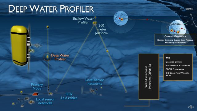
As with other Cabled Deep Profiler Moorings, this mooring contains a Wire-Following Profiler that transmits data both through WiFi, as well as through an inductive link at its basal docking station that is connected to the cable. The Wire-Following Profiler hosts six instruments and moves through the water column along the mooring cable, continuously sampling ocean characteristics over a specified depth interval (150 meters below sea surface to near bottom). The fiber-optic cable provides the mooring with significant power and bandwidth and is co-located with a Low-Power Jbox, that collects complementary water property data.
Read MoreRS03AXPS
The Axial Base Shallow Profiler Mooring located near the base of the Axial Seamount at the far western edge of the Juan de Fuca tectonic plate, at ~2,600 meters water deep.
Platform DOI and Citation Guidance
OOI assigns Digital Object Identifiers (DOIs) at the platform level. The DOI for the Axial Seamount Base Shallow Profiler Mooring is 10.58046/OOI-RS03AXPS.
The minimum recommended citation for this platform is:
NSF Ocean Observatories Initiative. (2014). Axial Seamount Base Shallow Profiler Mooring, DOI: 10.58046/OOI-RS03AXPS.
This follows the format NSF Ocean Observatories Initiative. (Year Published). Platform title, DOI: Platform DOI, where Year Published is the year OOI data collection began at the platform.
We encourage data users to incorporate full citations when referencing OOI data in order to support FAIR data principles and data traceability. OOI also provides further guidance on citations, including information on adding specific data products and data access points to citations.
Data Access
The following links provide data access via Data Explorer or other methods:
- Direct access to the data on this platform and its subcomponents
- General access to OOI data using a variety of methods
Platform Description
The Axial Base Shallow Profiler Mooring located near the base of the Axial Seamount at the far western edge of the Juan de Fuca tectonic plate, at ~2,600 meters water deep. Axial Seamount is the largest and most magmatically robust volcano on the Juan de Fuca Ridge The Axial Seamount is far from the continental shelf (>350 km) and represents an open-ocean or pelagic site in the continuum of observing scales represented in the OOI’s Cabled Array. Here, large-scale currents including the North Pacific Current, the subpolar gyre and the northern end of the California Current interact. These currents transport heat, salt, oxygen, and biota, all of which are crucial to the region’s ecosystem. However, their variability arises from forcing as varied as tides and winds to interannual (El Niño) to decadal (Pacific Decadal Oscillation) timescales. Because of its close proximity to the magmatically active volcano, instruments on the profiler may also capture perturbed water masses (e.g. megaplumes) resulting from underwater eruptions at the summit and along the flanks.
As with other Cabled Shallow Profiler Moorings, this mooring contains a Shallow Profiler (SF01A) and Platform Interface Controller (PC01A), hosted on a 12 ft across, 7 ton platform connected to the fiber-optic cable. The Shallow Profiler houses 10 scientific instruments and is tethered to a winch that pays out fiber optic cable allowing the profiler to rise through the water column until a fixed depth below the oceans surface. The specific depth is determined by currents and wave conditions at the surface. Eight instruments are also housed within the Platform Interface Controller mounted 200 m below the sea surface on the mooring platform. The fiber-optic cable provides the mooring with up to 3000 watts power and 10 Gb communication bandwidth and is co-located with a Low-Power Jbox that collects complementary water column data near the seafloor.
Read MoreRS03CCAL
The Central Caldera Medium-Power Jbox supports geophysical instruments in the north central portion of the Axial Seamount caldera at a water depth of ~1523 m. The instruments are attached to a Medium-Power J-Box and are mounted on the seafloor.
Site DOI and Citation Guidance
OOI assigns Digital Object Identifiers (DOIs) at the platform or site level. The DOI for the Axial Seamount Central Caldera is 10.58046/OOI-RS03CCAL.
The minimum recommended citation for this site is:
NSF Ocean Observatories Initiative. (2014). Axial Seamount Central Caldera, DOI: 10.58046/OOI-RS03CCAL.
This follows the format NSF Ocean Observatories Initiative. (Year Published). Site title, DOI: Site DOI, where Year Published is the year OOI data collection began at the site.
We encourage data users to incorporate full citations when referencing OOI data in order to support FAIR data principles and data traceability. OOI also provides further guidance on citations, including information on adding specific data products and data access points to citations.
Data Access
The following links provide data access via Data Explorer or other methods:
- Direct access to the data on this site and its subcomponents
- General access to OOI data using a variety of methods
Site Description
The Central Caldera Medium-Power Jbox supports geophysical instruments in the north central portion of the Axial Seamount caldera at a water depth of ~1523 m. The instruments are attached to a Medium-Power J-Box and are mounted on the seafloor. A broadband seismometer at this site is enclosed in bags of pea-sized gravel to dampen acoustic signals associated with currents in the area. The instruments are designed to measure local seismic events associated with migration of melt and volatiles within the volcano, as well as far-field seismic events. The instruments also measure uplift and deflation of the seafloor associated with ingress of melt within the underlying magma chamber, and collapse of the seafloor during diking-eruptive events. This site was chosen because Axial has erupted in 1988, 2011, and again in 2015. During the 2015 event, over 8,000 earthquakes were measured with the cabled geophysical array, and data were streamed live back to shore in real-time.
Seafloor instruments at Central Caldera are attached to a Medium-Power J-Box (MJ03F) through a series of extension cables. An ~ 4.7 km long extension cable from Primary Node PN3B provides the JBox with significant power (375 v) and bandwidth (1 Gbs) to operate the instruments and transmit data to shore.
Read MoreRS03ECAL
The Eastern Caldera Medium-Power Jbox supports geophysical instruments on the Eastern side of the 3 km across caldera at the summit of Axial Seamount. The instruments are attached to a Medium-Power J-Box and are mounted on the seafloor.
Site DOI and Citation Guidance
OOI assigns Digital Object Identifiers (DOIs) at the platform or site level. The DOI for the Axial Seamount Eastern Caldera is 10.58046/OOI-RS03ECAL.
The minimum recommended citation for this site is:
NSF Ocean Observatories Initiative. (2014). Axial Seamount Eastern Caldera, DOI: 10.58046/OOI-RS03ECAL.
This follows the format NSF Ocean Observatories Initiative. (Year Published). Site title, DOI: Site DOI, where Year Published is the year OOI data collection began at the site.
We encourage data users to incorporate full citations when referencing OOI data in order to support FAIR data principles and data traceability. OOI also provides further guidance on citations, including information on adding specific data products and data access points to citations.
Data Access
The following links provide data access via Data Explorer or other methods:
- Direct access to the data on this site and its subcomponents
- General access to OOI data using a variety of methods
Site Description
The Eastern Caldera Medium-Power Jbox supports geophysical instruments on the Eastern side of the 3 km across caldera at the summit of Axial Seamount. The instruments are attached to a Medium-Power J-Box and are mounted on the seafloor. The instruments are designed to measure local seismic events associated with migration of melt and volatiles within the volcano, as well as far-field seismic events. The instruments also measure uplift and deflation of the seafloor associated with ingress of melt within the underlying magma chamber, and collapse of the seafloor during diking-eruptive events. This site was chosen because Axial has erupted in 1988, 2011, and again in 2015. During the 2015 event, over 8,000 earthquakes were measured with the cabled geophysical array, and data were streamed live back to shore in real-time.
Seafloor instruments at Eastern Caldera are attached to a Medium-Power J-Box (MJ03E) through a series of extension cables. A 635 m long extension cable from Primary Node PN3B provides the JBox with significant power (375 v) and bandwidth (1 Gbs) to operate the instruments and transmit data to shore.
Read More