Posts Tagged ‘CGSN’
OOI Data Sonification
The assumption that quantitative data can be well represented not only in charts and graphs, but by increasingly sophisticated visual displays, is often taken for granted. However, researchers, instructors, and curators of museums and science centers also recognize that even the most sophisticated visual displays are inaccessible to those with low-vision or blindness. There is also the potential for alternative data presentation methods to improve understanding of complex data for sighted individuals. With these considerations in mind, a team led by Dr. Bower (WHOI) has pursued the creation of auditory displays or “data sonifications” using multi-disciplinary U.S. National Science Foundation Ocean Observatories Initiative (OOI) data sets as the basis. The results to date from the NSF-funded data sonification project are reported in a recent publication by Smith et al. (2024).
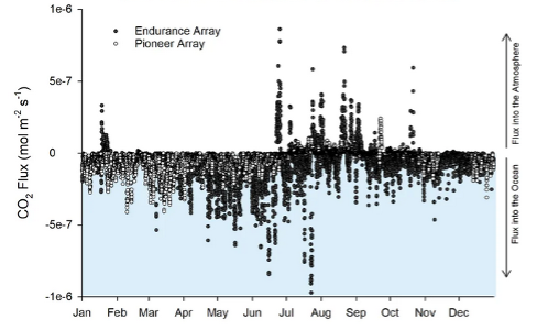
[media-caption path="https://oceanobservatories.org/wp-content/uploads/2024/05/Data-Sonification-figure.png" link="#"]Figure 1. Time series data from two data nuggets created by Ocean Data Labs that were used for sonification. Surface meteorology during the passage of hurricane Hermine over the Pioneer Array in 2016 (upper). The CO2 flux between ocean and atmosphere for both Pioneer (open circles) and Endurance Arrays during 2017 (lower).[/media-caption]Data sonification involves the mapping of quantitative data from its original form to audio signals in order to communicate complex information content. The project team was interested in using actual ocean data spanning a variety of oceanographic disciplines. Time series data produced by OOI sensors provide an excellent starting point. In particular, the Ocean Data Labs group at Rutgers has reviewed OOI data and created a set of “data nuggets” that are appropriate for sonification (Greengrove et al., 2020). The data nuggets comprise a broad range of oceanographic phenomena observed by OOI sensors, including response to a storm, the diurnal migration of zooplankton, a volcanic eruption, and the flux of CO2 between ocean and atmosphere.
The project team used a rigorous approach to developing and refining the auditory presentations. Starting with a set of learning objectives for each data nugget, a multi-step process was used to create the sonification. First, oceanographers were interviewed to establish the important points to be conveyed for a given data nugget. Next, classroom instructors were interviewed to get feedback on the most effective approaches to using sound to explain data properties. A sound designer then created an initial mapping of the data to sound, which was reviewed by a representative group of researchers, instructors, and blind and visually impaired listeners. After additional rounds of refinement and feedback, the prototype sonifications are now available. Two auditory displays utilizing Pioneer Array data (Fig. 1) are available at https://doi.org/10.5281/zenodo.8162769 and https://doi.org/10.5281/zenodo.8173880 for CO2 flux and storm response, respectively. Other examples can be found in Smith et al. (2024). The sonifications will be evaluated broadly using an on-line survey and by a “live audience” at museums and science centers.
This project is unique in exploiting the rich OOI data set and making ocean science highlights available to a broad community of students and the general public. A significant aspect of the work, as pointed out by the authors, is the systematic and inclusive approach used to develop the data sonifications. Results of the museum testing phase in 2024 will be awaited with great anticipation.
___________________
References:
Greengrove, C., S. Lichtenwalner, H.I. Palevsky, A. Pfeiffer-Herbert, S. Severmann, D. Soule, S. Murphy, L.M. Smith and K. Yarincik, 2020. Using authenticated data from NSF’s Ocean Observatories Initiative in undergraduate teaching, Oceanography, 33(1), 62-73.
Smith, L.M., A. Bower, J. Roberts, J. Bellona and J. Li, 2024. Expanding access to ocean science through inclusively designed data sonifications, Oceanography, 36(4), 96-101.
Read More
CGSN Events at OSM24
The Coastal and Global Scale Nodes (CGSN) group of the Ocean Observatories Initiative (OOI) is excited to be sharing recent technical and data advances with the Ocean Science community at the 2024 Ocean Sciences Meeting in New Orleans, LA. With a talk and poster, CGSN is demonstrating how we are advancing our ocean observing capabilities by (1) repurposing engineering data to expand wave observations, and (2) utilizing automated data quality control algorithms in an efficient way to identify storm events. These presentations exhibit how we are advancing our mission of being a science-driven ocean observing network that delivers real-time data from more than 900 instruments to address critical science questions regarding the world’s oceans.
The first opportunity to see CGSN in action at OSM24 is the talkExpanding surface wave observations at the OOI Pioneer Array – New England Shelf using buoy motion sensors at 9:00 am on Monday, Feb. 19th, as part of the session “OT11A: Innovation in in Situ Sensors and Sensing Platforms to Measure the Ocean I”. The Pioneer Array – New England Shelf collected data across the New England Shelf break for nine years from November 2013 through November 2022. Of the three surface moorings deployed across the array, only the Central Surface Mooring was equipped with a wave sensor. Recognizing that data from a single location could be restrictive for some types of analysis, CGSN identified an opportunity to increase the number of surface wave observations and extend their geographic extent to the full cross-shelf span of the Pioneer Array – New England Shelf. This was accomplished by using the engineering data (acceleration, angular rate, and magnetic vectors) collected by the MicroStrain 3-axis motion sensors (MOPAK) deployed on all three surface moorings. The data collected by the MOPAKs can be used to compute the bulk and directional wave statistics at each Surface Mooring in the array.
The next opportunity to learn about advances in CGSN data quality is at the posterApplication of Automated Quality Control Flags to OOI Data: Identification of Storm Events at Coastal Pioneer Array from 4 – 6 pm on Tuesday, Feb. 20th as part of the session “OT24B: Enhancing Data Quality Control in Ocean Sciences: Challenges and Innovations”. Quality control flags for the meteorological bulk flux package of instruments (METBK) from the recently-implemented quality tests based on the Integrated Ocean Observing System (IOOS) Quality Assurance / Quality Control of Real Time Oceanographic Data (QARTOD) standards may help data users identify and filter for events of interest that are hidden in OOI’s long-term records. The ability to flag interesting events is made more robust by the OOI Data Team’s efforts to complete data deep dives and add human-in-the-loop (HITL) annotations before the quality test thresholds are calculated. As a result of this process, the thresholds for barometric pressure recorded at the Pioneer Array – New England Shelf surface moorings are well-suited to identify storm events as unusually low pressure systems pass over the array.
These are two examples of ways that OOI is advancing the field of ocean observing and delivering science-ready data to the Ocean Sciences community.
Read MoreAUV Data Available in a Variety of Formats
We recently announced and demonstrated new access to autonomous underwater vehicle (AUV) data through OOI’s Data Explorer. Since the initial announcement, more has been done to provide additional AUV data and improve data delivery. As part of OOI’s efforts towards Findable, Accessible, Interoperable, and Reusable (FAIR) data, not only are AUV data easier to find and access, we now are providing these data in more interoperable and reusable formats.
When you view an AUV Deployment in Data Explorer (FIG 1), data in different formats may be accessed either through the Metadata link in the left panel (FIG 1 A) or the Downloads button (FIG 1 B). The Downloads button provides access to data products, in formats including comma separated variable (CSV), that are derived from Network Common Data Form (NetCDF) files in the OOI Raw Data Repository. To access these NetCDF files, open the Metadata link, navigate into that deployment’s folder, and then into its PROFILES subfolder. Note that each deployment’s folder also contains raw data as collected by the vehicle and an EXPORTED subfolder for data products in Matlab format.
[media-caption path="https://oceanobservatories.org/wp-content/uploads/2024/01/AUV_OOI_newsletter_Fig1_portrait.png" link="#"]Fig. 1 AUV Deployment in Data Explorer. Inset A: Metadata link to Raw Data Repository to access NetCDF format per deployment in PROFILES subfolder. Inset B: Downloads button provides data products in multiple formats. Credits: Screen grab from Data Explorer (https://dataexplorer.oceanobservatories.org/#platform/c646022c-ce04-5be8-8cd8-117da55121fa/v2?pid=14&tab=visualization) and Flaticon. Flaticon license: Free for personal and commercial use with attribution.[/media-caption]The software development effort by OOI’s Coastal & Global Scale Nodes (CGSN) Team to publish AUV data into Data Explorer involved OOI’s Cyberinfrastructure Team and Axiom Data Science. This effort builds on earlier work by OOI’s Coastal Endurance Array Team to publish glider data into the IOOS Glider DAC, and subsequently into OOI’s Data Explorer. The existing code base was integrated into a larger framework supporting the input of either glider or AUV data and supporting output formatting compatible with either or both the Glider DAC or Data Explorer.
CGSN maintains two AUV platforms, which are deployed from shipboard as part of at-sea operations in and around OOI mooring sites. The AUVs conduct ~24 hour transects, consisting of multiple profiles of the water column, before being retrieved by the ship for data collection and maintenance. CGSN AUV platforms are fitted out with a variety of instrumentation including CTD, fluorometer, and sensors for photosynthetically active radiation, dissolved oxygen, dissolved nitrate, and current measurement. When applicable, annotations are provided per deployment per instrument in OOI’s OOINet portal and M2M (Machine to Machine) interface; we plan to incorporate these annotations into NetCDF metadata and ultimately into Data Explorer.
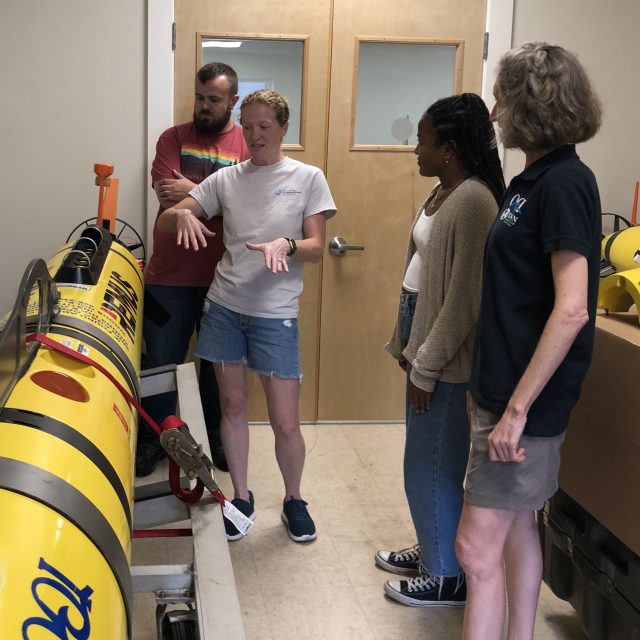
[media-caption path="https://oceanobservatories.org/wp-content/uploads/2024/01/IMG_126519-2.jpg" link="#"]CGSN Team member Diana Wickman (2nd from left) explains how the AUV moves during a deployment, with CGSN Team members Collin Dobson (far left) and Stace Beaulieu (far right) and student researcher Taina Sanchez (2nd from right). Credit: D. Trew Crist © WHOI.[/media-caption]
The Data Explorer provides access to all across-shelf and along-shelf AUV deployments at the Coastal Pioneer NES Array from 2016 to 2022.Future AUV transect data at the Coastal Pioneer MAB Array will also be published through Data Explorer as the data become available. As an example for reusability of these data in newly-available formats, a student examined across-shelf patterns in salinity, chlorophyll, and nitrate as part of Northeast U.S. Shelf Long-Term Ecological Research.
Read More
Biofouling Mitigation from Top to Bottom
OOI operates its arrays in challenging environments. At the sea surface, sea lions find the buoys attractive resting spots. At the bottom, instruments must collect data under varying temperatures at intense pressures. And, then throughout the water column’s photic zone is marine growth. Marine life finds OOI’s instrumentation and arrays irresistible, where it attaches and grows like gangbusters.
The folks who keep OOI’s arrays operational explain the conditions this way:
“Putting any kind of instrumentation – electrical or scientific instrumentation – in the water for a year or more at a time is always a challenge, said Dana Manalang, Engineer, OOI Regional Cabled Array (RCA). “It’s a harsh environment due to the high pressures and salt water so getting systems to operate sub-seas is the largest challenge we face.”
“It’s a challenging place to work,” concluded Coastal Endurance Array Project Manager Jonathan Fram, “And, we are very thankful to have the opportunity to make stuff that can survive in just about any marine environment.”
So how do they do it? OOI engineers develop creative ways to tackle the many challenges, particularly in terms of some of the peskier, persistent ones like keeping marine growth, referred hereafter as biofouling, at bay.
Diaper cream as a solution
Coastal and Global Scale Node (CGSN), Coastal Endurance, and RCA team members have implemented novel ways to minimize and in-situ clean marine growth on sensors, gliders, and components of the arrays that spend up to 12 months in the water.
One such novelty is the application of diaper cream. An inexpensive and convenient form of zinc oxide, diaper cream, has been used for decades as a marine anti-foulant, with moderate effectiveness. . “Its application for oceanographic equipment goes back at least to the 1990’s, and is considered non-toxic relative to other concoctions, “ explained Peter Brickley, CGSN Observatory Operations Lead. Other anti-fouling scheme exist, but some are expensive, some add weight, while others take too long to apply and don’t fit into the team’s operational deployment plans.
“The only downside is that diaper cream has be to done onboard right before deployment, or it’s a mess,” he added.
Coastal Endurance Project Manager Jonathan Fram said, “One key issue is that gliders are made of aluminum, so we can’t use copper-based antifouling material on them. Diaper cream is zinc-based, so it won’t corrode gliders’ aluminum.” The Coastal Endurance Team regularly applies diaper cream to its glider fleet, with measurable success. “Gliders with barnacles on them can’t swim straight or efficiently. The diaper cream provides a protective coating to which marine growth cannot readily adhere. It helps keep our gliders moving easily through the water and reporting data.”
[media-caption path="https://oceanobservatories.org/wp-content/uploads/2023/12/Diaper-cream-117.jpg" link="#"]Coastal Endurance team members Raelynn Heinitz and Alex Wick apply diaper cream before launch of a glider off the Oregon coast. The ointment prevents marine growth on gliders that traverse the shallow coastal waters near the Endurance Array’s Washington and Oregon-Newport lines. Marine organisms thrive in the shallow water where sunlight can penetrate, aiding marine growth. Credit: Kathy Hough, NOAA.[/media-caption] [media-caption path="https://oceanobservatories.org/wp-content/uploads/2023/12/without-diaper-cream.jpg" link="#"]Shown above is a recovered glider having spent three months in the upper coastal waters off the Washington coast. It would have been covered with marine life, imperiling its ability to maneuver, but the protective diaper cream kept most of them at bay. Credit: Kathy Hough, NOAA.[/media-caption]After being successfully tested on gliders, the Coastal Endurance Array and RCA teams then tried the protective diaper cream as an option to keeping acoustic transducers on the arrays clean, as suggested by the vendor. An acoustic transducer is an electrical device that vibrates, producing sound waves in water. OOI uses transducers in both echosounders and hydrophones. Here, too, the diaper cream proved to be an inexpensive and effective biofouling mitigation measure.
[media-caption path="https://oceanobservatories.org/wp-content/uploads/2023/12/acoustic-transducer.jpg" link="#"]An acoustic transducer covered with diaper cream to prevent biofouling during its six-months in the water. Credit: Kathy Hough, NOAA.[/media-caption]Addition of UV lights
Putting ultraviolet lights in the water to discourage marine growth is another proven biofouling mitigation measure. Early on, the Coastal Endurance team deployed two oxygen optodes, which measure dissolved oxygen, side-by-side at seven meters depth on the Oregon Shelf Surface Mooring with a UV light pointed at one of them. Data from the two sensors tracked each other for six weeks after which the unprotected sensor fouled. Within weeks, there were daily afternoon spikes of up to twice the oxygen level of the protected sensor, with slightly lower measurements than the unprotected sensor at night due to respiration of the biofilm. Since this test, optodes are regularly deployed with UV lights to aid their operation. (Annotations of OOI moored oxygen data note when a UV light was not operating with it.)
Following the success of the UV-light on dissolved oxygen sensors, the CGSN team tested this antifouling measure on a moored Coastal Pioneer Array spectral irradiance (SPKIR) sensor, which measures the amount of light energy that reaches a surface. The testing was conducted with Sea Bird Scientific, the SPKIR vendor. The vendor confirmed that the UV light did not damage the instrument’s optics nor did it interfere with its light measurements. After this confirmation and positive result, UV lights are now used on all SPKIR sensors on Surface Moorings, Coastal Surface Piercing Profilers, and uncabled digital still cameras moored at less than 70 meters. The teams adjust the on/off cycle of the UV lights so that biofouling is prevented without damaging the sensors, interfering with measurements, or using too much power.
[media-caption path="https://oceanobservatories.org/wp-content/uploads/2023/12/Screenshot-2023-11-27-at-6.02.17-PM.jpeg" link="#"]Sea Bird Scientific’s spectral irradiance sensor needs to be clean to effectively measure light energy in the water column. Shining UV lights on these sensors helps to minimize biofouling and clouding of the sensor.Credit: Sea Bird Scientific.[/media-caption]Lens-Cleaning Brushes
The RCA also has adopted novel ways to deal with biofouling on the Pacific Ocean seafloor. RCA operates and maintains a high-definition (HD) video camera (CAMHD) at the base of an actively venting hydrothermal chimney called “Mushroom” (see below) in the ASHES vent field of Axial Seamount Caldera. Live HD video of this > 4-m high chimney and surrounding seafloor is streamed to shore on an automated schedule for 14 minutes at 3-hour intervals, with longer non-stop monitoring for 24 hours twice a month and 72 hours at the beginning of each month.
[media-caption path="https://oceanobservatories.org/wp-content/uploads/2023/12/Figure-a.jpg" link="#"]RCA’s high-definition video camera installed next to “Mushroom” hydrothermal chimney in the ASHES vent field of Axial Caldera. Credit: UW/NSF-OOI/WHOI; J2-1534, V23.[/media-caption]The scene is fully scanned with programmable pan, tilt, and zoom functions of this instrument, which provides detailed imagery of the high-temperature water spigots, sea spiders, lipets tube worms and other biota covering both the chimney and surrounding lava-covered seafloor.
[media-caption path="https://oceanobservatories.org/wp-content/uploads/2023/12/Figure-b.jpg" link="#"]Close-up of the RCA HD video camera at the base of “Mushroom” hydrothermal chimney. Credit: UW/NSF-OOI/WHOI; J2-1534, V23.[/media-caption]Unfortunately, such live subjects, microorganisms, and other organic/inorganic processes often deposit a film on the camera lens which interferes with visualization. To ensure optimal clarity of HD video between site maintenance visits during annual RCA operation and maintenance expeditions, an automated lens cleaning protocol using a simple brush, installed on the instrument’s frame in the front of the lens has been instituted.
[media-caption path="https://oceanobservatories.org/wp-content/uploads/2023/12/Figure-c-.png" link="#"]Lens-cleaning brush, indicated by red arrow, installed in front of RCA’s HD video camera and used during an automated cleaning protocol. Credit: UW/NSF-OOI/WHOI; J2-1534, V23..[/media-caption]This programmed event occurs three times a month and tilts the camera down and pans it left and right, allowing the brush to gently clean the lens. The video streaming and lens cleaning schedules can be optimized remotely from shore by RCA personnel to provide the highest scientific and educational value from the HD video.
Eco Anti-fouling paint
Ever wonder why OOI’s buoys are painted blue? This eco-friendly paint serves the same purpose as diaper cream and UV lights—to minimize marine growth on the buoys and its metal components. The teams use a commercially available water-based and copper-free anti-fouling paint. Once recovered, the CGSN and Coastal Endurance Array components are taken apart and refurbished so they function like new once ready to be redeployed. All metal components and float areas are cleaned and receive a fresh coat of paint in the hope of diminishing their attractiveness to life below the surface.
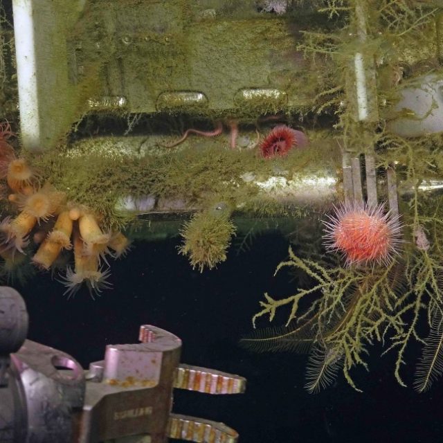
[media-caption path="https://oceanobservatories.org/wp-content/uploads/2023/12/predeployment.png" link="#"]Pre-deployment: The Coastal Pioneer buoys assembled, painted and ready for deployment for six months in the Atlantic Ocean, off the coast of Martha’s Vineyard. Credit: Derek Buffitt © WHOI.[/media-caption] [media-caption path="https://oceanobservatories.org/wp-content/uploads/2023/12/Biofouled-mooring-in-air-2023-03-17-13-33-17-2.jpg" link="#"]After six months in the northeast Pacific, the Coastal Endurance Surface mooring buoy had become a rich habitat for marine life. Credit: Kim Kenney, OSU.[/media-caption] [media-caption path="https://oceanobservatories.org/wp-content/uploads/2023/12/Pink-sea-urchins.jpg" link="#"]Biofouling can be beautiful, as demonstrated here as the ROV Jason prepares to recover the RCA Shallow Profiler during its annual operations and maintenance expedition. Credit: UW/NSF-OOI/WHOI; J2-1516: v23.[/media-caption]
Read More
Spreading Curiosity about Ocean Science with Summer Visitors
Summertime brings students from all over the country to Woods Hole, Massachusetts to learn about ocean science. June and July 2023 were particularly busy, with the Coastal and Global Scale Nodes (CGSN) division of the Ocean Observatories Initiative (OOI) at Woods Hole Oceanographic Institution (WHOI) hosting four different student groups. CGSN offers student tours of OOI facilities and the chance to talk directly with an ocean scientist or engineer. They engage with students this way in the hope of increasing student interest in marine science and possibly encouraging them to pursue an ocean-related career. During the tours and presentations, students learn about the moorings and vehicles OOI deploys throughout the year and the dissemination of ocean data collected. These hands-on experiences give student visitors the opportunity to see the full scale and complexity of OOI operations.
UMass-Dartmouth REU Students Visit
On June 26, 12 community college engineering student and faculty from a National Science Foundation (NSF) sponsored Research Experience for Undergraduate (REU) at the University of Massachusetts, Dartmouth (UMass-Dartmouth) visited OOI. CGSN staff provided a tour of their operations, including ocean-observing equipment stored outdoors because of its size.
[media-caption path="https://oceanobservatories.org/wp-content/uploads/2023/07/Sheri-with-REUs.jpg" link="#"]CGSN team members, Dr. Sheri White (blue jeans to right) and Irene Duran (next to Dr. White) gave a tour to UMass-Dartmouth REU students. Photo by: Kama Theiler © WHOI.[/media-caption] [media-caption path="https://oceanobservatories.org/wp-content/uploads/2023/07/Colin-Dobson-with-REU.jpg" link="#"]A UMass-Dartmouth REU student asks CGSN glider expert Colin Dobson a question regarding the gliders he works on. Photo by: Kama Theiler © WHOI.[/media-caption]PEP Students Visit
In early July, the CGSN team gave a presentation to Woods Hole Partnership Education Program (PEP) participants, who spend 10-weeks in Woods Hole at WHOI, the Marine Biological Laboratory, Woodwell Climate Research Center, National Oceanic and Atmospheric Administration’s Northeast Fisheries Science Center, Sea Education Association, or the United States Geological Survey’s Woods Hole Coastal and Marine Science Center. The PEP program is designed primarily for college juniors and seniors from underrepresented groups in marine and ocean sciences who want to spend a summer gaining practical experience in marine and environmental science.
Summer 2023 is the 15th summer of the PEP program in Woods Hole. Many former PEP students have returned to Woods Hole and WHOI both as students and professionals (including CGSN’s Irene Duran). Benjamin Harden, PEP professor, stated that OOI’s community outreach is a “great way for these students to hear about the frontiers of oceanography and really helped many of them frame possible careers in the field.”
Black Girls Dive Foundation Visit
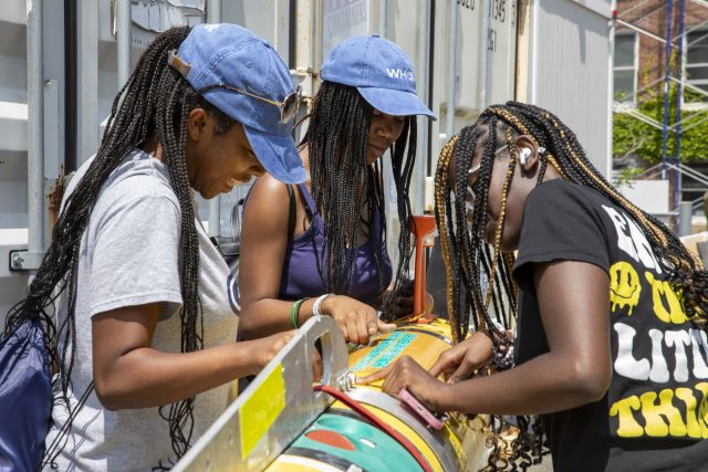
July 25th, CGSN’s Electrical Team provided a workshop to the Black Girls Dive Foundation (BGDF) program participants. BGDF provides the space and opportunity to empower young black women to explore their STEM (Science, Technology, Engineering and Mathematics) identity through marine science and conservation, and SCUBA diving. While visiting OOI, the BGDF students learned about pH and concerns about increasing ocean acidification. The students collected local sea water and with the help of the CGSN Instrument Team determined its pH with a probe they calibrated using a microcontroller.
[media-caption path="https://oceanobservatories.org/wp-content/uploads/2023/07/BGDF-with-AUV.jpg" link="#"]During their visit to WHOI, BGDF students had the opportunity to get up close to check out an Autonomous Underwater Vehicle (AUV). Photo by: Jayne Doucette © WHOI.[/media-caption] [media-caption path="https://oceanobservatories.org/wp-content/uploads/2023/07/Jennifer-with-BGDF.jpg" link="#"]CGSN Instrument Lead Jennifer Batryn (far left) shows how she checks OOI instruments operations on her laptop to one of the BGDF visitors. Photo by: Jayne Doucette © WHOI.[/media-caption]SEA Participants Visit
Also in late July a group of students participating in the Sea Education Association’s (SEA’s) High School program visited OOI’s Facility LOSOS on WHOI’s Quissett Campus. This is a study abroad program in Woods Hole for undergraduate, gap year, and high school students, that combines studies in ocean science with at-sea experiences. The students spent an afternoon learning about OOI, its operations, how data are collected and disbursed, and what scientists are learning from OOI data.
[media-caption path="https://oceanobservatories.org/wp-content/uploads/2023/07/Dee-and-Jon-With-SEA-students-2.jpg" link="#"]CGSN team members Dee Emrich (standing left) and John Lund explained OOI operations to high school students from the Sea Education Program. Photo by: Dr. Sheri White © WHOI.[/media-caption] [media-caption path="https://oceanobservatories.org/wp-content/uploads/2023/07/Irene-with-SEA-students.jpg" link="#"]CGSN Engineer Irene Duran (maroon top in center) showed mooring components to high school students from the Sea Education Program. Photo by: Paul Whelan © WHOI.[/media-caption] Read MoreGlobal Irminger Sea Array Expedition
New OOI Coastal Surface Mooring Design
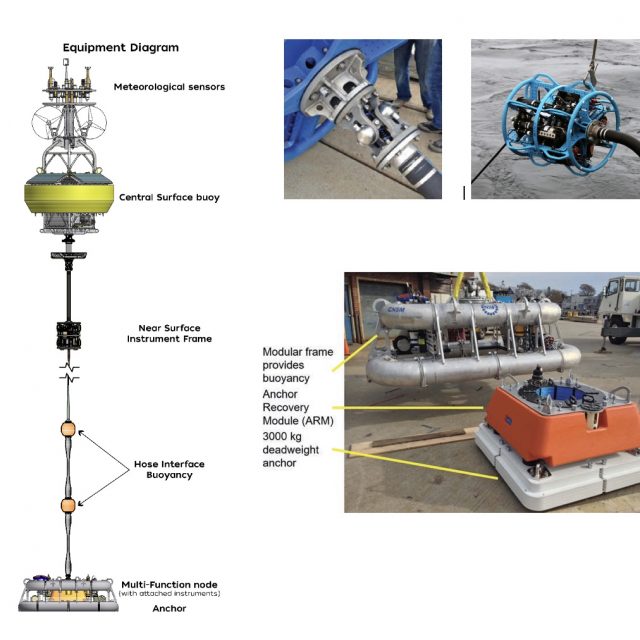
The OOI Coastal Surface Moorings (CSMs) showcase a variety of innovative mooring technologies. Although the design concepts were initially developed as elements of other mooring systems, they were brought together for the first time on the OOI CSM. A recent paper by Peters et al. (2022) describes three areas where new design concepts were particularly impactful: (1) components at the interface between the surface buoy and mooring riser, (2) mooring riser components, and (3) an integrated seafloor anchor and instrument frame. These components work together to provide mechanical integrity for the mooring as well as mounting points for instrumentation and a reliable electrical pathway for the transmission of power from the surface to the seafloor and data from the seafloor to the buoy (Figure above).
Components comprising the buoy-to-riser interface include a universal joint, an electro-mechanical (EM) chain, and a Near Surface Instrument Frame (NSIF). The universal joint, at the buoy base, reduces the translation of buoy pitch and roll motion into bending moments at the top of the mooring riser. The EM chain, a conventional chain wrapped with helically-wound conductors and encapsulated in urethane, provides a flexible strength member between the buoy and the NSIF. The NSIF provides a mounting point for instruments and a mechanical transition from the EM chain to the EM cable.
Components along the mooring riser include the EM cable, EM stretch hoses, and distributed buoyancy elements between stretch hoses. The EM cable employs a wire rope strength member mechanically terminated with a swaged fitting. A molded urethane strain relief boot at the upper end of the cable interfaces with the NSIF bellmouth. The lower termination assembly provides strain relief and a cavity for integration of underwater connectors. The EM stretch hoses were initially developed in the 1990s by WHOI engineer Walter Paul. A novel, multi-layer construction technique was developed for OOI to enable a 24-conductor stretch hose. Hose lengths from 9 to 30 m are employed on OOI moorings. Each hose has a breaking strength of over 10,000 lb and stretches to over twice its original length to provide variable mooring scope and reduction of peak dynamic loads.
At the buoy base is an integrated anchor and instrument frame assembly called the Mult-Function Node (MFN). The MFN frame is a buoyant structure made of air-filled aluminum pipe, configured to allow the mounting of instruments, data loggers and batteries. The MFN is weighted to the seafloor with an anchor assembly that sits in the center of the frame, connected with dual acoustic releases. The anchor assembly consists of a flat-plate anchor below a foam buoyancy element that contains an internal spool with several hundred meters of synthetic line. The buoyancy element is connected to the anchor with dual acoustic releases. This system allows for mooring and anchor recovery in three stages: First, the MFN is separated from the anchor and the mooring riser is recovered. Next, the buoyancy element is released from the anchor allowing it to rise to the surface while offspooling line. Finally, the anchor is hauled using the synthetic line.
This unique combination of design elements creates a mooring system capable of housing and powering complex instrument systems, transmitting data in near real-time, and contributing to the long-term reliability of the OOI Coastal Surface Moorings in the challenging environment of the continental shelf.
Peters, D.B, J.N. Kemp and A.J. Plueddemann (2022). Coastal Surface Mooring Developments for the Ocean Observatories Initiative (OOI). Marine Technol. Soc. J., 56(6), 70-74. doi.org/10.4031/MTSJ.56.6.2.
Read MoreChlorophyll Enhancement at the Shelfbreak
Adapted and condensed by OOI from Oliver et al., 2022, doi:/10.1029/2021JC017715.
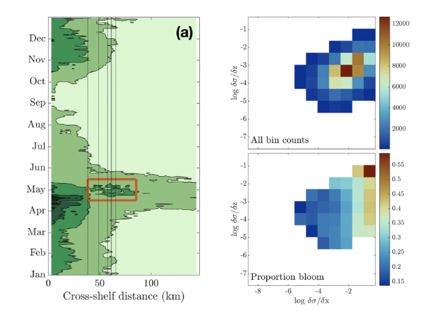
[media-caption path="/wp-content/uploads/2022/08/Screen-Shot-2022-08-18-at-3.10.51-PM.png" link="#"](left) Eighteen-year composite annual cycle of surface chlorophyll concentration from MODIS satellite. Vertical lines indicate the shelfbfreak region (depths 75 to 1,000 m); red box highlights chlorophyll enhancement at the shelfbreak. (right; upper) OOI glider data with more than 100 chlorophyll observations within horizontal and vertical density gradient bins and (lower) proportion of bins with chlorophyll > 2 mg/L, indicating a bloom. From Oliver et al., 2022.[/media-caption]The enhancement of chlorophyll due to phytoplankton blooms is recognized to occur near the frontal boundary of the New England Shelf, but the blooms are ephemeral and not consistently found in satellite remote sensing of ocean color. In a recent study, Oliver et al., (2021) show that enhanced surface chlorophyll concentrations at the shelfbreak are short lived events, and are associated with periods when a surface layer of lighter shelf water moves over denser slope water at the shelfbreak front. Both data and a computational model show that eastward, upwelling-favorable winds are the primary driver of the frontal restratification and localized enhanced surface chlorophyll.
The study used a variety of data sources, including MODIS satellite chlorophyll estimates, shipboard CTD casts from a Shelf-break Productivity Interdisciplinary Research Operation at the Pioneer Array (SPIROPA) cruise and a Pioneer mooring turn cruise, Pioneer glider density and chlorophyll, and atmospheric reanalysis winds after comparison with Pioneer surface mooring winds. A two-dimensional configuration of the Regional Ocean Model System (ROMS) coupled to a nitrogen-phytoplankton-zooplankton-detritus (NPZD) model was used to simulate the wind-driven response.
The eighteen-year time-evolution of the cross-shelf distribution of surface chlorophyll concentration from MODIS showed that shelf-break chlorophyll enhancements were evident in most years, followed an inshore spring bloom in April, and were typically seen during a short period in the spring (mid-April – mid-May; Figure above). For individual years, the shelf-break chlorophyll enhancements were short-lived, typically lasting less than a week. Pioneer Array glider data were used to explore the relationship between enhanced chlorophyll concentrations and both horizontal (assumed to be associated with the shelfbreak front) and vertical density gradients. Near surface (upper 30 m) chlorophyll concentrations were collected in log-transformed density gradient bins and then displayed according to the proportion of bins with chlorophyll > 2 mg/L, indicating a bloom. The “bloom bins” were associated with high horizontal density gradients and a range of vertical density gradients, indicating that frontal restratification is associated with enhanced chlorophyll at the shelfbreak (Figure above).
The study concludes that enhanced surface chlorophyll events at the New England shelfbreak occur consistently in the spring, but are transient, lasting only a few days to a week, and thus not discernible in seasonal climatologies. Periods of enhanced chlorophyll are associated with strong horizontal density gradients and appear to be triggered by the increase in stratification resulting from wind-driven cross-shelf advection of less dense shelf water over denser slope water. This process creates a shallow mixed layer at the front which alleviates light limitation and supports transient surface enhancements of chlorophyll.
Oliver, H., Zhang, W.G., Archibald, K.M., Hirzel, A.J., Smith, W.O. Jr, Sosik, H.M., Stanley, R.H.F and D.J. McGillicuddy Jr (2022). Ephemeral surface chlorophyll enhancement at the New England shelf break driven by Ekman restratification. Journal of Geophysical Research: Oceans, 127, e2021JC017715. https://doi.org/10.1029/2021JC017715.
Read MoreAtlantic Water Influence on Glacier Retreat
Adapted and condensed by OOI from Snow et al., 2021, doi:/10.1029/2020JC016509
The warming of Atlantic Water along Greenland’s southeast coast has been considered a potential driver of glacier retreat in recent decades. In particular, changes in Atlantic Water circulation may be related to periods of more rapid glacier retreat. Further investigation requires an understanding of the regional circulation. The nearshore East Greenland Coastal Current and the Irminger Current over the continental slope are relatively well studied, but their interactions with circulation further offshore are not clear, in part due to relatively sparse observations prior to establishing the OOI Irminger Sea Array and the Overturning in the Subpolar North Atlantic Program (OSNAP).
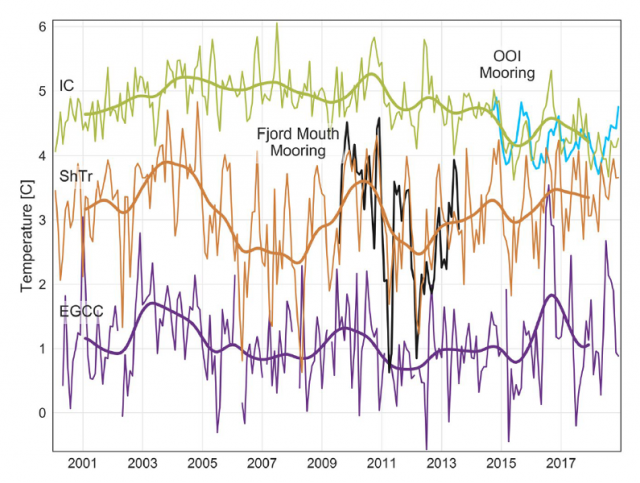
[media-caption path="/wp-content/uploads/2022/04/Pioneer-highlight.png" link="#"]Satellite-derived sea surface temperature after adjustment for the Irminger Current (IC; green), Shelf Trough (ShTr; orange), and East Greenland Coastal Current (EGCC; purple). Monthly values (thin lines) are shown for 2000-2018 with 24-month low-passed records overlain. In situ observations from the fjord mouth (290 m: Black) and OOI flanking mooring FLMA (180 m; blue) are shown for comparison.[/media-caption]
In a recent study (Snow et al., 2021) use in-situ mooring data to validate satellite SST records and then use the 19-year satellite record to investigate relationships between glacier melt and Atlantic Water variability. In order to use the satellite records for this purpose, several adjustments must be made, including accounting for cloud and sea ice contamination, eliminating seasonally-varying diurnal biases, and removing the influence of air temperature. This adjusted satellite SST can be compared to in-situ mooring data during a portion of the record. A coastal mooring near the Sermilik Fjord mouth and the OOI Irminger Sea Array provide useful records during 2009-2013 and 2014-2018, respectively (Figure 24). An interesting aspect is that the temperature record from OOI Flanking Mooring A (FLMA) is useful for this purpose even though the measurements are at 180 m depth. This is because the upper ocean is relatively homogeneous in this region, and the mixed layer is deeper than 180 m during much of the year. The authors find that the adjusted satellite SST is consistent with the in-situ records on monthly to interannual time scales (Figure above). This provided the motivation to investigate relationships between the 19 year satellite record and glacier discharge rates.
The study concludes that warmer upper ocean temperatures as far offshore as the OOI Irminger Sea Array were concurrent with increased glacier retreat in the early 2000s, in support of the idea that Atlantic Water circulation plays a role. However, they also note that this influence is not direct, because of substantial variation in how Atlantic Water is diluted as it flows across the shelf towards Sermilik Fjord. The idea that time-varying dilution of Atlantic Water governs the temperature of water reaching the glacier was not previously understood, and resolving such small-scale, time-varying processes is a challenge for models. The authors conclude that with appropriate adjustments, “[satellite] SSTs show promise in application to a wide range of polar oceanography and glaciology questions” and that the method can be generalized to other glacier outflow systems in southeast Greenland to complement relatively sparse in-situ records.
Snow, T., Straneo, F., Holte, J., Grigsby, S., Abdalati, W., & Scambos, T. (2021). More than skin deep: Sea surface temperature as a means of inferring Atlantic Water variability on the southeast Greenland continental shelf near Helheim Glacier. J. Geophys. Res: Oceans, 126, e2020JC016509. https://doi.org/10.1029/2020JC016509.
Read MorePioneer Relocation Update 2021-09-29
The Pioneer Array, currently sited on the New England Shelf (NES), was conceived within OOI as a re-locatable, coastal array (OOI Science Plan, 2001; OOI Science Prospectus, 2007). At the Fall 2020 American Geophysical Union meeting, the National Science Foundation announced the start of a process for relocation of the Array. After a variety of community engagement activities and two intensive Innovations Labs, it was determined that the Pioneer Array will be relocated to the southern Middle Atlantic Bight (MAB). Existing infrastructure, with some modifications, will be utilized to create a new Array to address compelling science questions at the new site.
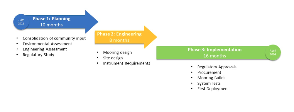
The OOI Program is consolidating the community input and preparing for Pioneer relocation activities. The overall effort is complex, and will span roughly 30 months. In order to provide a window for these efforts within the existing operational budget, there will be a pause in Pioneer field activities. Preliminary plans are for the final recovery of the NES Pioneer Array in the fall of 2022 and the initial deployment of the MAB Array in the spring of 2024. The figure below shows the anticipated timeline, with three main phases. Phase 1 will focus on preparatory activities, including environmental and engineering assessments, and a study of regulatory requirements. During Phase 2, the bulk of the engineering and design effort will be conducted. During Phase 3, environmental compliance and permitting will be completed, along with the preparation of the infrastructure for deployment.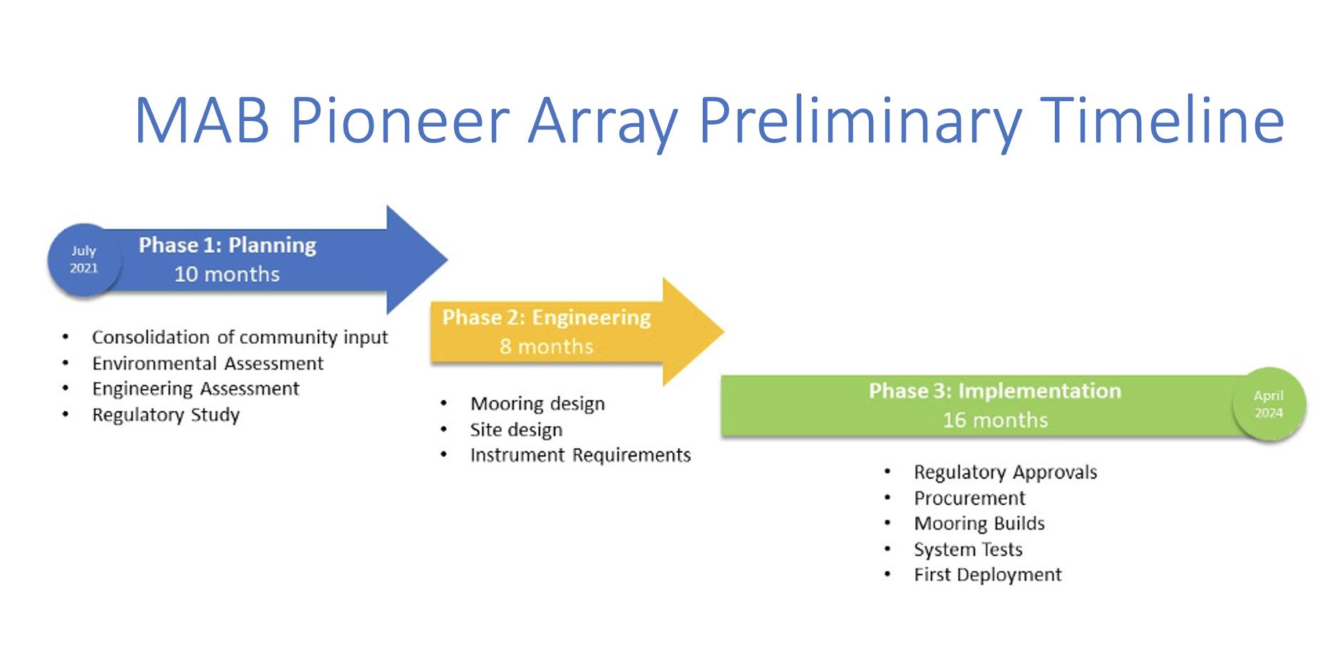
Read More

