
Posts Tagged ‘Coastal Pioneer’
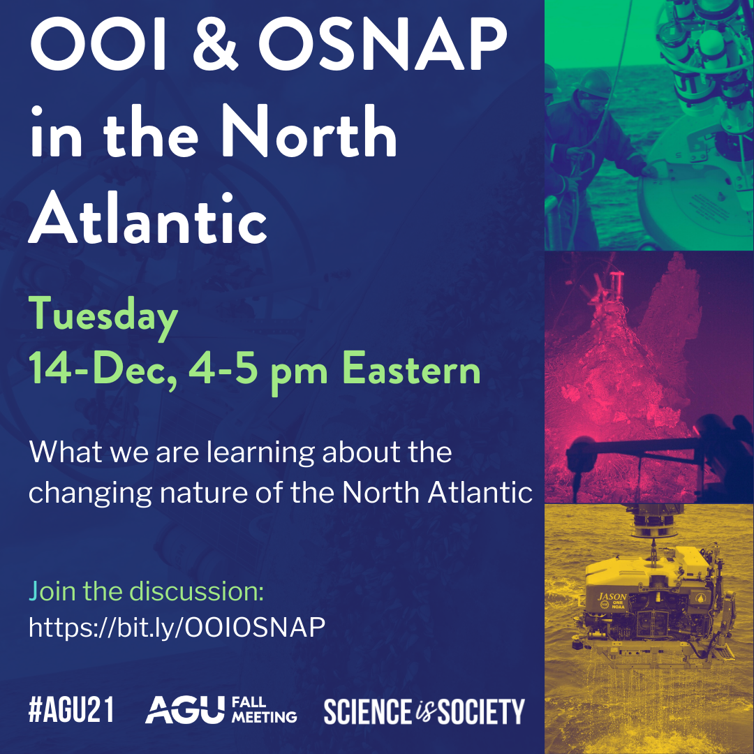
OOI Pioneer and Global Arrays: March Virtual Office Hours
The Ocean Observatories Initiative (OOI) Coastal Pioneer and Global Arrays Data Team at Woods Hole Oceanographic Institution is excited to introduce our virtual office hours, where we’ll be available to address any data related questions, assist with data access and navigating the data visualization and download system and offer general support. Hosted via Zoom, these sessions are open to all users; please register for Zoom link (using the form linked below).
Register: OOI Pioneer and Global Arrays Virtual Office Hours
What to expect:
- Join any time during the hour; stay as long as you like.
- When you join the Zoom you’ll enter the main room. There may already be a demo or discussion in progress. Feel free to post your question and/or ask for a breakout room in the Zoom chat.
- Breakout rooms will be available for smaller group discussion and/or to share screens.
These Office Hours will be guided by the AGU Meetings Code of Conduct; in addition, there will be no recording nor AI tools logging into the Zoom. Please report any issues to OOI Leadership.
Details: Tuesday, March 10th, 3-4pm ET
Read MoreTest Deployments Underway for Pioneer Relocation
Tuesday February 21, 2023, a team of scientists and engineers from Woods Hole Oceanographic Institution (WHOI) left Charleston, SC aboard the R/V Neil Armstrong to begin test deployments in preparation for the installation of an Ocean Observatories Initiative (OOI) ocean observing system in its new location in the southern Mid-Atlantic Bight (MAB). The science team will deploy two test moorings off the coast of North Carolina, occupying shallow and deep sites of the proposed array. The deployments will supplement computer modeling to ensure the mooring designs perform as expected in the MAB environment. Once the array is fully operational in 2024, the ocean data collected will be available online in near real-time to anyone with an Internet connection.
Ocean observing data helps to track, predict, manage, and adapt to changes in the marine environment. Coastal communities use ocean observing data to prepare for floods and other natural disasters. The instrumented arrays gather physical, chemical, geological, and biological data from the air-sea interface to the seafloor, providing a wealth of information for research and education.
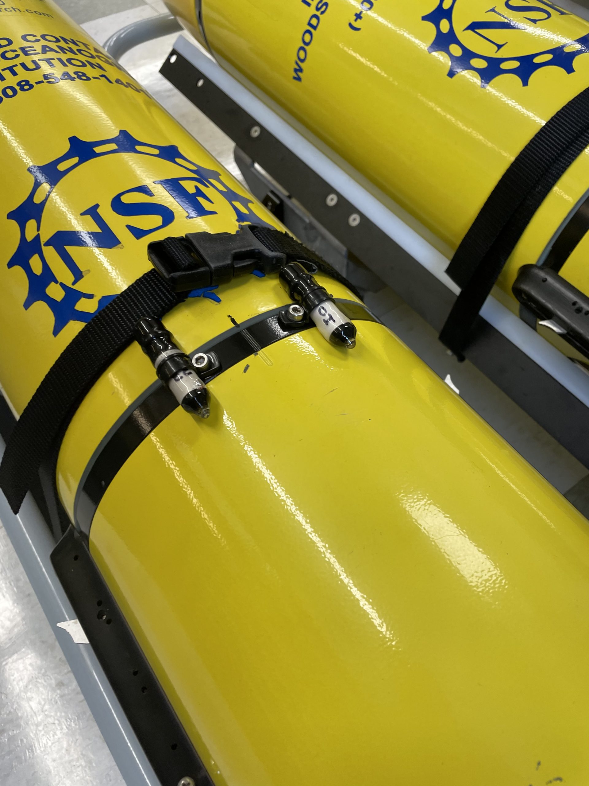
[media-caption path="https://oceanobservatories.org/wp-content/uploads/2023/02/CNSM_buoy_atsea-2-1.png" link="#"]Offshore conditions can be brutal for moorings that remain in the water for six-month deployments. The new location for the OOI’s Coastal Pioneer Array is designed to withstand treacherous conditions, including extreme storms. Credit: ©Woods Hole Oceanographic Institution.[/media-caption]“This new Pioneer Array location in the MAB offers many opportunities for scientists to obtain data to further their research, and will provide better insight into conditions in the area for a variety of stakeholders,“ said Al Plueddemann, Project Scientist for OOI’s Coastal and Global Scale Nodes group at WHOI, which is responsible for operation of the Pioneer Array. “We welcome researchers, educators, and industry members to reach out to us to explore ways we might work together to maximize the usefulness of the data.”
The OOI is funded by the National Science Foundation (NSF) to collect and deliver ocean data in select locations for 25 years or more. This longevity of data collection makes it possible for researchers to identify both short term processes and long-term trends in our changing ocean. The OOI’s Coastal Pioneer Array was designed to be relocatable, and its first deployment was off the coast of New England at the Continental Shelf/Slope interface, where it collected data from 2016 until it was recovered in September 2022. The new location off the coast of North Carolina was chosen by NSF based on input from the science community during a series of NSF-sponsored workshops in 2022.
Dr. Reide Corbett, Executive Director of the Eastern Carolina University’s Coastal Studies Institute (CSI), is enthusiastic about the opportunities the Pioneer Array will bring to the region. “The cross-shelf suite of instrumentation off northeastern North Carolina’s coast is in a region of complex physics and critical ecosystem dynamics that draws interest from many disciplines and creates opportunities for transformational science. This is also in a region with a growing renewable energy sector, including two active offshore wind leases, with opportunities to partner with the agencies involved. The Coastal Studies Institute is excited about the observations that will be made from these instruments, allowing us to better address climate change influences in the coastal ocean, and improve ocean/weather/storm forecasts through data sharing. Beyond just the instruments in the water, the new partnerships and collaborations created as part of this deployment will provide the ability to better engage this socio-economically diverse region, with disadvantaged groups more impacted by sea level rise and climate change compared to many coastal regions. This broad network of partnerships across the region will provide a mechanism to drive knowledge to action,” states Corbett.
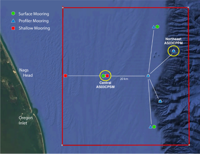
[media-caption path="https://oceanobservatories.org/wp-content/uploads/2023/02/Pioneer-MAB-schematic.png" link="#"]Schematic drawing of the Pioneer MAB moored array to be deployed off the coast of Nags Head, North Carolina. The full array, to be deployed in the spring of 2024, will consist of ten moorings at seven different sites (three sites contain mooring pairs). For the test deployment, one Coastal Surface Mooring will be deployed at the Central site and one Coastal Profiler Mooring will be deployed at the Northeast site.[/media-caption]The new MAB site represents a different environment than the New England Shelf location and offers opportunities to collect data on a variety of cross-disciplinary science topics, including cross-shelf exchange and Gulf Stream influences, land-sea interactions associated with large estuarine systems, a highly productive ecosystem with major fisheries, processes driving biogeochemical cycling and transport, and fresh-water outflows during extreme rain events.
The MAB location is expected to have different wind, wave, and current conditions than the Pioneer Array experienced on the New England Shelf. In addition, deployments in the new location will be in both shallower and deeper water depths than those off the New England coast.
A Coastal Surface Mooring (CSM) will be deployed at 30 meters depth at 35o 57.00’ N, 75o 07.5’ W. The CSM is specifically designed to examine coastal-scale phenomena and withstand the challenging conditions of shallow coastal environments. The Surface Mooring contains instruments attached to a Surface Buoy floating on the sea surface, a Near Surface Instrument Frame 7 meters below the surface, and a Seafloor Multi-Function Node (MFN) located on the seafloor. Additionally, the Surface Buoy contains wind turbines and solar panels for power generation and antennas to transmit data to shore via satellite.
A Coastal Profiler Mooring (CPM) will be deployed at 600 meters depth, 36o 03.80’ N, 74o 44.56’ W. The CPM contains a Wire-Following Profiler that houses instruments. The Wire-Following Profiler moves through the water column along the mooring riser, continuously sampling ocean characteristics from about 23 m below the surface to 23 m above the sea floor. The CPMs also carry an upward-looking Acoustic Doppler Current Profiler to measure ocean currents over the same region of the water column traversed by the profiler.
The test mooring data will be evaluated during the deployment and after recovery to determine whether any modifications are needed to the mooring designs. The plan is to deploy the full array in the spring 2024.
An update on the Pioneer Array relocation is planned for April 20 at 6 pm at the Coastal Studies Institute on East Carolina University’s Outer Banks Campus. Contributing to the CSI “Science on the Sound” lecture series, WHOI’s Dr. Plueddemann will discuss the Pioneer Array infrastructure, instrumentation, and what is planned for its upcoming move off the North Carolina coast. The event is free and open to the public. For those unable to attend, the program will be live-streamed, as well as archived for later viewing, on the CSI YouTube Channel.
[media-caption path="https://oceanobservatories.org/wp-content/uploads/2023/02/A-Frame.png" link="#"]An A-frame at the stern of the ship is used to lift an OOI Coastal Surface Mooring into the water at the start of the deployment. A team secures guidelines to ensure its movements are controlled. Credit: Darlene Trew Crist © WHOI.[/media-caption] [media-caption path="https://oceanobservatories.org/wp-content/uploads/2023/02/DSC0418-scaled.jpg" link="#"]Surface Mooring Recovery operations. Credit: Deidre Emrich © WHOI.[/media-caption]
Read More
Scientists and Fishers Learning from One Another

At a recent meeting of the Cape Cod Commercial Fishermen’s Alliance, it was evident how much can be learned when scientists and fishers share information. An example was the shifting location of the Gulf Stream. Fred Mattera, President of Commercial Fisheries Research Foundation of Rhode Island, wondered why the temperature of the continental shelf was 72 degrees in December. He contacted Glen Gawarkiewicz, a Woods Hole Oceanographic Institution senior scientist, to share his observation. Gawarkiewicz used data from OOI’s Coastal Pioneer Array to confirm that the Gulf Stream, which carries warm and salty water, had shifted 120 miles north. Gawarkiewicz explained to the audience that he would have never identified this change if it hadn’t been for Mattera’s contact.
This is but one example of how those who use the ocean and those who study it can benefit by sharing information. To read more:
Read More
Chlorophyll Enhancement at the Shelfbreak
Adapted and condensed by OOI from Oliver et al., 2022, doi:/10.1029/2021JC017715.
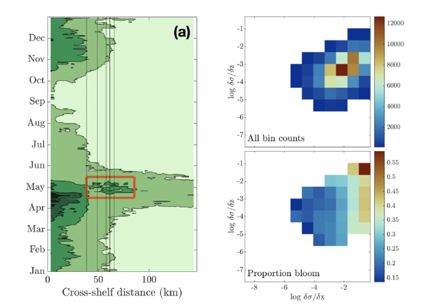
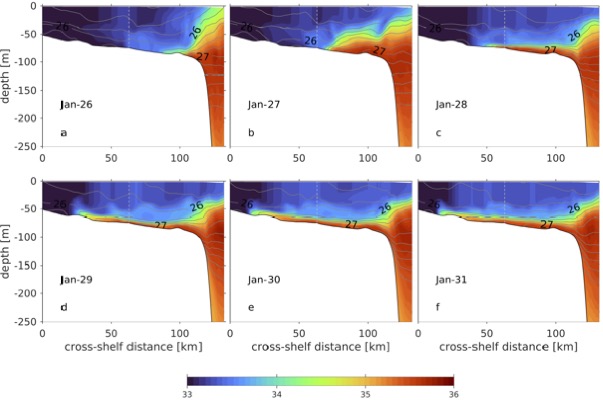
[media-caption path="/wp-content/uploads/2022/08/Screen-Shot-2022-08-18-at-3.10.51-PM.png" link="#"](left) Eighteen-year composite annual cycle of surface chlorophyll concentration from MODIS satellite. Vertical lines indicate the shelfbfreak region (depths 75 to 1,000 m); red box highlights chlorophyll enhancement at the shelfbreak. (right; upper) OOI glider data with more than 100 chlorophyll observations within horizontal and vertical density gradient bins and (lower) proportion of bins with chlorophyll > 2 mg/L, indicating a bloom. From Oliver et al., 2022.[/media-caption]The enhancement of chlorophyll due to phytoplankton blooms is recognized to occur near the frontal boundary of the New England Shelf, but the blooms are ephemeral and not consistently found in satellite remote sensing of ocean color. In a recent study, Oliver et al., (2021) show that enhanced surface chlorophyll concentrations at the shelfbreak are short lived events, and are associated with periods when a surface layer of lighter shelf water moves over denser slope water at the shelfbreak front. Both data and a computational model show that eastward, upwelling-favorable winds are the primary driver of the frontal restratification and localized enhanced surface chlorophyll.
The study used a variety of data sources, including MODIS satellite chlorophyll estimates, shipboard CTD casts from a Shelf-break Productivity Interdisciplinary Research Operation at the Pioneer Array (SPIROPA) cruise and a Pioneer mooring turn cruise, Pioneer glider density and chlorophyll, and atmospheric reanalysis winds after comparison with Pioneer surface mooring winds. A two-dimensional configuration of the Regional Ocean Model System (ROMS) coupled to a nitrogen-phytoplankton-zooplankton-detritus (NPZD) model was used to simulate the wind-driven response.
The eighteen-year time-evolution of the cross-shelf distribution of surface chlorophyll concentration from MODIS showed that shelf-break chlorophyll enhancements were evident in most years, followed an inshore spring bloom in April, and were typically seen during a short period in the spring (mid-April – mid-May; Figure above). For individual years, the shelf-break chlorophyll enhancements were short-lived, typically lasting less than a week. Pioneer Array glider data were used to explore the relationship between enhanced chlorophyll concentrations and both horizontal (assumed to be associated with the shelfbreak front) and vertical density gradients. Near surface (upper 30 m) chlorophyll concentrations were collected in log-transformed density gradient bins and then displayed according to the proportion of bins with chlorophyll > 2 mg/L, indicating a bloom. The “bloom bins” were associated with high horizontal density gradients and a range of vertical density gradients, indicating that frontal restratification is associated with enhanced chlorophyll at the shelfbreak (Figure above).
The study concludes that enhanced surface chlorophyll events at the New England shelfbreak occur consistently in the spring, but are transient, lasting only a few days to a week, and thus not discernible in seasonal climatologies. Periods of enhanced chlorophyll are associated with strong horizontal density gradients and appear to be triggered by the increase in stratification resulting from wind-driven cross-shelf advection of less dense shelf water over denser slope water. This process creates a shallow mixed layer at the front which alleviates light limitation and supports transient surface enhancements of chlorophyll.
Oliver, H., Zhang, W.G., Archibald, K.M., Hirzel, A.J., Smith, W.O. Jr, Sosik, H.M., Stanley, R.H.F and D.J. McGillicuddy Jr (2022). Ephemeral surface chlorophyll enhancement at the New England shelf break driven by Ekman restratification. Journal of Geophysical Research: Oceans, 127, e2021JC017715. https://doi.org/10.1029/2021JC017715.
Read More18th Turn of the Pioneer Array in April
Sixteen science party members will be on board the R/V Neil Armstrong during April for each of two legs comprising the eighteenth turn of the Pioneer Array, where moorings are recovered and new ones deployed. This April cruise will be extremely busy, with 32 overall objectives, as well as other ancillary operations. Pioneer 18 is the first cruise since 2020, when COVID-19 protocols were implemented, to support a larger science party to conduct ancillary activities.
The cruise plan calls for deployment of eight moorings and three gliders and recovery of 10 moorings. Autonomous underwater vehicle (AUV) missions will be conducted in the vicinity of the moored array, providing additional ocean observing measurements. CTD casts and water sampling will be done in conjunction with deployment/recovery operations and ship vs. buoy meteorological comparisons will be made at each Coastal Surface Mooring site.
[media-caption path="/wp-content/uploads/2022/03/DSC0507.jpg" link="#"]During Pioneer 18, ten moorings will be recovered. Once close to the ship, crew members grab the moorings with a hook, and direct them to the stern of the ship to be brought onboard. Credit: Darlene Trew Crist ©WHOI.[/media-caption]
“We are pleased to be approaching full capability for Pioneer 18 after multiple cruises with COVID-related restrictions,” said Al Plueddemann, chief scientist for Pioneer 18 and lead for the Ocean Observatories Initiative Coastal and Global Scale Node of which the Pioneer Array is part. “There is a lot to accomplish over our 21 days at sea, and having the opportunity again to bring collaborating scientists onboard will make full use of the ship and our time at sea.”
On Leg 1, Scientists Mei Sato of Woods Hole Oceanographic Institution (WHOI) will join Pioneer 18 to conduct zooplankton sonar testing, Peter Duley of the National Oceanic and Atmospheric Administration will conduct Marine Mammal Observations, and a student from the University of Rhode Island will oversee a glider deployment. Additionally, unattended underway sampling will be conducted in support of the Northeast U.S. Shelf (NES) Long-Term Ecological Research (LTER) project on Leg 1. On Leg 2, NES-LTER efforts will increase, with four participants (two from WHOI and two from the University of Rhode Island) onboard to conduct activities that include CTD and ring net casts and incubations, as well as continuing unattended underway sampling.
[media-caption path="/wp-content/uploads/2022/03/IMG_6146.jpeg" link="#"]Plans are to deploy three gliders that will collect data in the water column between the Pioneer moorings for the next sixth months. Credit: Darlene Trew Crist ©WHOI.[/media-caption]
Weather conditions and time constraints during the Pioneer 17 cruise precluded complete recovery of the Offshore and Upstream Offshore Profiler Moorings. Additional objectives for Pioneer 18, to be conducted if time and conditions permit, include completing the recovery of these two moorings, as well as several anchor recoveries using a remotely operated vehicle (ROV), glider tests, and surveys in the vicinity of the Pioneer moored array using shipboard systems (CTD, ADCP, EK-80).
“We have a very ambitious agenda for Pioneer-18, but our team is experienced and well-equipped to complete this large list of tasks ,” added Plueddemann. “We just need a good weather window to get the job done.”
Pioneer 18 team members will be sharing their progress during the month of April. Bookmark this page and follow along.
Read More
Tracking Fish with Acoustics
New RAFOS Ocean Acoustic Monitoring (ROAM) tags have recently been designed to allow geolocation of underwater assets, including pelagic fishes, over large areas in the ocean and even deep into the ocean’s twilight zone.
[caption id="attachment_22879" align="alignleft" width="350"]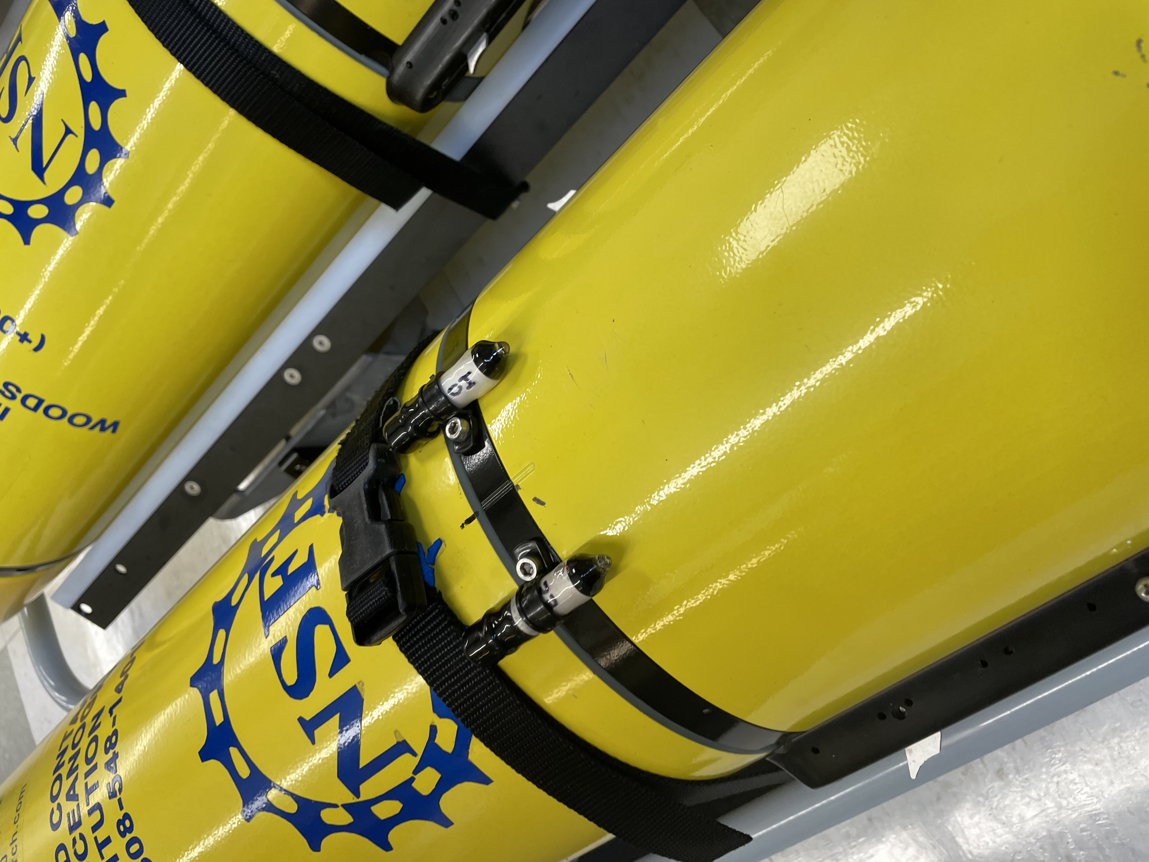 The ROAM tag is small (30 mm x 10 mm) and light enough (8 gm in water) to be attached to an ocean glider with no adverse impacts on performance. Here are two ROAM tags attached to OOI test glider 363 before deployment from the R/V Armstrong during the Pioneer 17 cruise. Credit: ©WHOI, Diana Wickman.[/caption]
An opportunity to test the new ROAM tags arose in conjunction with the October 2021 Pioneer Array mooring service cruise. “We had recently deployed moored sound sources in deep water between Cape Cod and Bermuda,” said Simon Thorrold who, with University of Rhode Island colleagues Melissa Omand and Godi Fischer, is leading the ROAM fish tag development. “One of our goals was to determine whether tagged fish near the continental slope south of New England could be detected using these distant sources.” Thorrold reached out to the OOI team to see if there was potential for a short-term test at the Pioneer Array site, located 75 nautical miles south of Martha’s Vineyard at the shelf-slope interface.
OOI Project Scientist Al Plueddemann and the OOI glider team determined that a glider test planned during the mooring service cruise in late October would be happening at the right place and the right time to be useful for testing the acoustic tags. “This technology is something we would like to consider for OOI, and in particular for the Pioneer Array in its new southern Mid- Atlantic Bight location,” said Plueddemann, “so the potential for a test was of interest to us.”
The glider team determined that the small (30×10 mm), light (8 gm in water) tags would have no measurable impact on glider performance and could be safely accommodated on the test glider. The tags were mounted to the glider by fitting the tags into plastic loop clamps and then securing the loop clamps to existing threaded holes in the glider hull. During the three-day test deployment, the glider made one dive to 50m, one dive to 200m, three dives to 500m, and approximately 76 dives to 200m.
The glider data and acoustic tag data are being evaluated, and will provide information about fish tag performance and the potential for future use within the OOI arrays.
This article was written by Woods Hole Oceanographic Institution colleagues: Senior Scientist Simon Thorrold and Senior Engineering Assistant II Diana Wickman.
Read MoreOOI’s Contributions to Understanding the Changing Ocean Cited in Boston Globe
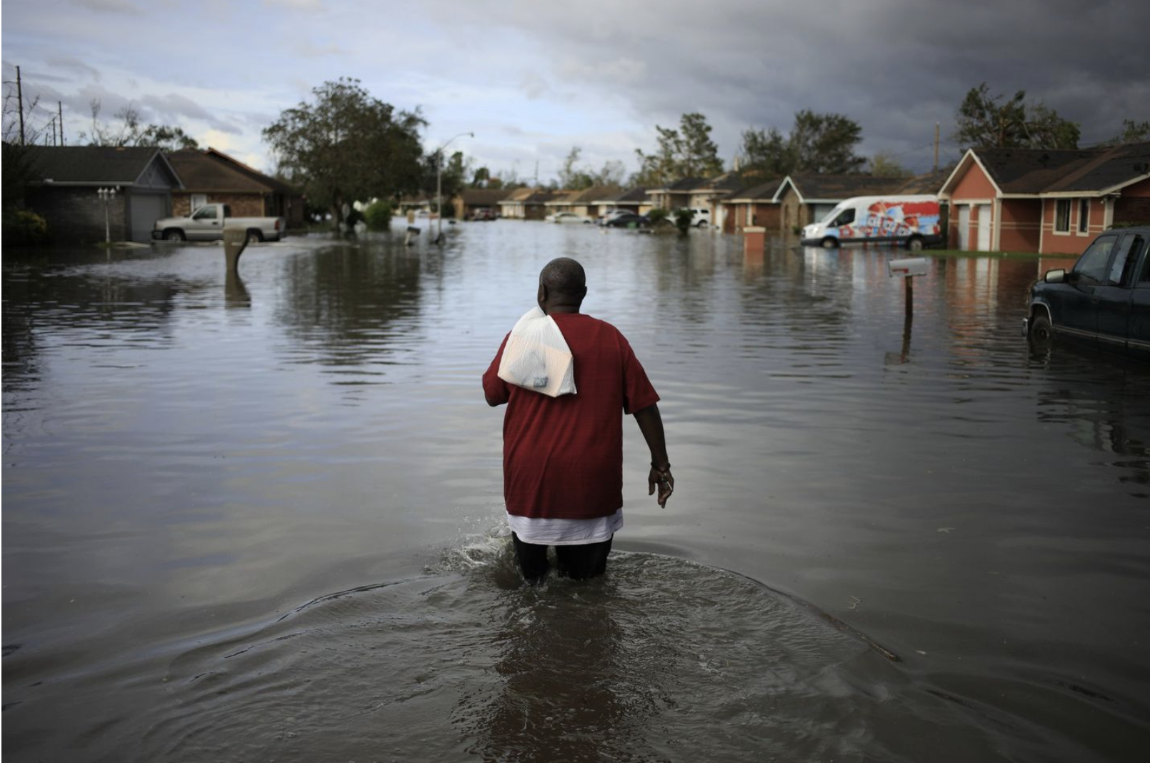
Woods Hole Oceanographic Institution Research Scientist Glen Gawarkiewicz cites how he uses OOI data to figure out what is happening in the changing ocean in an article on that appeared on the front page of the Boston Globe on December 28, 2021.
In a record-breaking year of weather, signs of a changed world.
[caption id="attachment_22801" align="alignnone" width="1610"] A resident walked through floodwaters left by Hurricane Ida in La Place Louisiana on August 30, 2921. Credit: Luke Sharrett/Bloomberg via the Boston Globe.[/caption]
Read More Gulf Stream Species in Cold North Waters Spur Scientific Discovery
In early 2017, something strange was going on in the waters off the coast of Rhode Island. Fishers were pulling up a very unusual bycatch of Gulf Stream flounder and juvenile Black Sea bass. The Gulf Stream flounder are typically found in warmer waters, and while black sea bass are a very common fish, they are typically not present in cold water in the middle of winter, particularly not their juveniles. The fish coming up in their nets were so unusual for this time of the year, that a member of the Commercial Fisheries Research Foundation (CFRF) sent a photograph to Woods Hole Oceanographic Institution (WHOI) scientist Glen Gawarkiewicz asking what he thought might be causing these tropical fish to end up in cold New England waters in the dead of winter.
[media-caption path="/wp-content/uploads/2021/12/Flounder-1.jpeg" link="#"]Anna Mercer from CFRF sent this photo of Gulf Stream flounder and juvenile Black Sea Bass to Glen Gawarkiewicz, launching an investigation that resulted in three research papers.[/media-caption]
“One fun thing about my relationship with the fishing community now is if they see unusual things, they send them to me. And then I’ll usually go right to the Pioneer Array website, look at the data and see if there’s some kind of a story, I can tell about the oceanographic conditions that might have given rise to unusual features, or unusual fish,” said Gawarkiewicz.
This query about an unusual catch prompted a scientific investigation whose results were recently published in the Journal of Geophysical Research: Oceans. The authors, WHOI colleagues Ke Chen, Glen Gawarkiewicz, and Jiayan Yang, identified for the first time the cause and multi-faceted dynamics at play in a subsurface marine heat wave (a high temperature anomaly event), expanding views of contributing factors to such ocean-altering events. They pinpointed the interplay between smaller scale cyclonic eddies and warm water intrusions that created an anomalous marine heat wave.
The research team started with the traditional hypothesis that warm core rings at the shelf break were pushing warm and salty water onto the shelf towards shore, generating a marine heat wave. But after analyzing the fishing data and oceanographic data from the Pioneer Array, the team was not able to pinpoint the exact process causing the marine heat wave. Chen took up the challenge and created a numerical model simulating ocean conditions during November 2016-February 2017.
The model, which was at an exceptionally fine scale of 1 kilometer resolution, captured what the team saw from the data. The model revealed warm core rings were not solely responsible for the increase in temperature of water moving into shore, but rather the heated, salty water was being moved by a combination of previously overlooked smaller scale cyclone-like eddies (circular currents of water) in the periphery of the warm core ring. The model also revealed a very persistent wind blowing from west to east in late January 2017 that worked jointly with the cyclonic eddies that had already changed the outer shelf conditions.
The winds brought the warm and salty water from the shelf break to around 50 meters depth for a distance larger than 100 kilometers over five-six days. The intrusion was localized. It moved along the slope, climbed up the shelf, and moved onshore.
“So this remarkable intrusion was really different from what has been known of the dynamics contributing to onshore intrusions for this region, “explained Chen. “It is a very new and exciting finding that such intrusions can be a combination of smaller scale eddies and wind causing warm water intrusions at a particular location.” The model shows the complexity of such intrusions that may result from multiple sources and conditions. “It provides a more complete picture of conditions and how they might ultimately impact what fish are caught and where they are caught,” added Chen.
Gawarkiewicz concluded, “The Pioneer Array has just worked wonders for our relationship with the fishing industry and has also allowed us to see ongoing changes in this ocean region that keep accelerating. The Pioneer Array just brilliantly combines both the cutting-edge research, like the modeling Ke is doing, with the real dire societal need of identifying and ultimately understanding changing ocean conditions. I only wish that we could have a Pioneer Array, basically in every region of the country.”
____________________________________________
See Boston Globe article on December 28, 2021 for other ways OOI data are contributing to scientific understanding of the changing ocean.
Read More
Videos of OOI’s Virtual Booth Sessions at AGU
In case you missed any sessions at OOI’s Virtual Booth at the AGU Fall 2021 meeting, you can watch them here at your leisure:
[embed]https://vimeo.com/657572792[/embed] [embed]https://vimeo.com/657554340[/embed] [embed]https://vimeo.com/657568018[/embed] [embed]https://vimeo.com/657540648[/embed] [embed]https://vimeo.com/657477409[/embed] [embed]https://vimeo.com/657874176[/embed] [embed]https://vimeo.com/657995699[/embed] Read MoreTesting of New Glider Models Underway
Last fall, the Coastal Endurance team conducted an initial test run of a Slocum G3 glider to determine its capabilities and operational differences to the G2 glider, currently used by the Endurance and Coastal & Global Scale Nodes (CGSN) teams. The test was prompted by glider vendor Teledyne’s announcement that it would no longer support the G2 glider past 2023.
Both the Endurance and CGSN teams have since expanded testing. The Endurance team recently completed a two-month deployment of a G3 glider, with plans to deploy another later this summer. The CGSN team, which operates the Pioneer and two global arrays, is testing three G3 gliders. One is being tested for use as a coastal glider at the Pioneer Array and the other two are being configured for the Irminger Sea and Station Papa global sites.
“Recent testing at the Pioneer Array was really valuable for us,” said Peter Brickley, CGSN Observatory Operations Lead. “We got a chance to see that our missions were workable, we found and made the changes that were needed, and we were also able to get a better estimate of how much energy these things were going to use.”
[media-caption path="https://oceanobservatories.org/wp-content/uploads/2021/07/IMG_3107-2-1-scaled.jpg" link="#"]Diana Wickman of the CGSN team at Woods Hole Oceanographic Institution is responsible for keeping the CGSN gliders operational. Here she has stripped the exterior of the glider to ensure that all internal parts are functional. Once refurbished, the gliders are tested in a water tank before being deployed at sea. Credit: Jade Lin ©WHOI.[/media-caption]The G3 gliders use more power than the G2 gliders, so the logistics of when and where they are deployed will require some adjustments. When powered by primary lithium batteries, for example, the G2 gliders can be deployed for about 90 days. The initial tests of the G3 gliders showed they could last in the water for around 75 days using primary lithium batteries. For trial runs using rechargeable batteries, the time in the water for the G3 gliders was reduced to about 30 days.
OOI is working with the vendor to evaluate operational alternatives to extend the operating window of the G3 gliders.
Improvements may require tweaking
“The rechargeable batteries are a really cool feature, but because they are about half of the energy density of the usual batteries, we’re going to have to adjust sampling schemes and plans for time in the water when we use the rechargeable batteries,” said Stuart Pearce, who works with the Endurance gliders. For now, the Endurance team intends to test the rechargeable batteries in the near shore gliders in the spring and summer when they can reliably get out to sea to recover and deploy the gliders.
G3 gliders also come equipped with larger volume buoyancy pumps than the G2 models in response to users’ feedback. “The gliders rise and fall in the water column by changing their volume and therefore density,” explained Pearce. “The new gliders have 800-1000 cubic centimeters of fluid volume to rise and dive with, compared to the 500 cubic centimeters of volume in the G2 gliders. This means that the G3 gliders can climb and dive in a greater buoyancy range.” One option being explored is whether power consumption can be reduced by adjusting the volume of the reservoir fluid needed to make the glider rise and fall.
The new G3 gliders incorporate some changes that address feedback from OOI and other users who have operated G2 gliders. “If you put anything in the ocean and use it as much as we do, you will find things that unexpectedly fail,” said Peter Brickley, CGSN Observatory Operations Lead. “We’ve been operating gliders since 2013, so we have lots of experience. In the early days, for example, we had a lot of problems with the digifin, the steering rudder that’s on the back of the vehicle. We worked closely with Teledyne to document and study this issue and they ultimately made needed improvements.” Other issues have been similarly addressed over the years.
Integrating the new G3 gliders into its Global Arrays may offer greater reliability as older G2 models are phased out. Diana Wickman, Senior Engineering Assistant II at Woods Hole Oceanographic Institution who keeps the CGSN gliders operational, explained “We need the equipment to work really well, and it needs to work for the entire year. At Pioneer, if we have problems, we can replace vehicles that are struggling with vehicles that we can refurbish in-house, but we simply can’t do that at the global sites.”
For now, the teams will continue with testing to make sure the new gliders will work for OOI’s purpose of long-term ocean monitoring.
OOI shares its glider data with the Integrated Ocean Observing System (IOOS) Glider Data Assembly Center and the OceanGliders project, which is a part of the Global Ocean Observing System (GOOS). Both serve as repositories for researchers interested in using glider data.
Read More