
Posts by Leslie Smith
OOIFB Administrative Support Office Solicitation
The NSF is accepting proposals for the Ocean Observatories Initiative Facility Board (OOIFB) Administrative Support Office.
Read MoreEos – Incorporating Observatory Data into Oceanography Courses
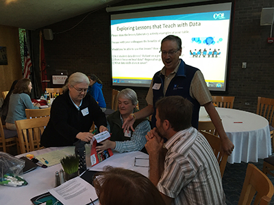
OOI Teaching with Data Workshops; New Brunswick, New Jersey, 19–21 May 2017 (chemistry) and 2–4 June 2017 (geology)
Read MoreMachine to Machine Interface Resources and Community Tools
The OOI is pleased to announce the release of the OOI Machine-to-Machine (M2M) interface for data download.
The M2M interface provides programmatic access to OOI data and metadata via a RESTful Application Programming Interface (API). It allows authenticated users to request small amounts of data via synchronous JSON requests, request larger amounts of data in NetCDF or CSV format in order to download multiple data streams or data from multiple platforms, or set up recurring downloads to procedurally update an existing dataset. Additional commands allow for searches of the asset management system to find deployment, calibration, quality control (QC) parameters, annotations, and other information, both in bulk and for specific instruments or platforms.
Full documentation of the M2M system is underway, but there are several existing “Community Tools” resources to assist in getting started using the API. Step by step instructions and sample code are now available on the OOI Website. In addition, the OOI Data Evaluation Team will be holding instructional webinars and posting additional guides and video tutorials in the Knowledge Base in the coming months.
For additional help using the interface, if you encounter errors, or if you have suggestions, please contact the HelpDesk.
Read MoreRFQ for OOI Location and Equipment Placement Maps

COL seeks a Contractor for graphic design services to design a suite of aesthetically consistent base maps and technical schematics for the project (further described in Section C and Attachment #1 (Statement of Work).
Read MoreGeekWire – Wave Broadband partners with UW to boost ocean observatory’s fiber connections
Wave Broadband is coming out in the open about its partnership with the University of Washington to provide broadband connectivity for the Regional Cabled Array, an undersea observatory that’s part of the federally backed Ocean Observatories Initiative.
Read MoreWEBINAR: Dec. 1, 2017 Cabled Array Staff Consultation
Friday, December 1, 2017 at 10 AM PST/1 PM EST
Cabled Array staff will provide an overview of the Cabled Array infrastructure currently deployed as well as engineering specifics including connectors, communication capabilities, testing procedures, and general timeline. The goal of the webinar is to provide researchers interested in adding instrumentation-infrastructure onto the Cabled Array the information required to submit an NSF proposal, which includes a letter from the Cabled Array team on technical feasibility. Awards have been made for addition of infrastructure onto the Cabled Array from NSF, ONR, and International collaborators.
[button link="https://docs.google.com/forms/d/e/1FAIpQLSemcNMpnYk1ekcZRHopOVnsETEVyTBGgf_PtqtVxisCipkgvg/viewform?usp=sf_link" bg_color="#00a9dd" window="yes"]Register Here[/button]
Please RSVP by Nov. 30
Maintenance Update: Shore Station Maintenance Successful with no Data Interruption
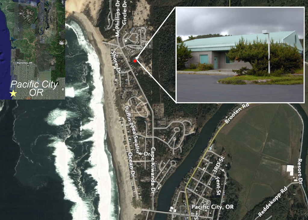
On Thursday 9 November 2017 the Cabled Array team conducted several required maintenance tasks at the Shore Station in Pacific City, OR. All maintenance tasks were successfully completed without powering down the system, as originally anticipated.
Read MoreOOI Update – Fall 2017
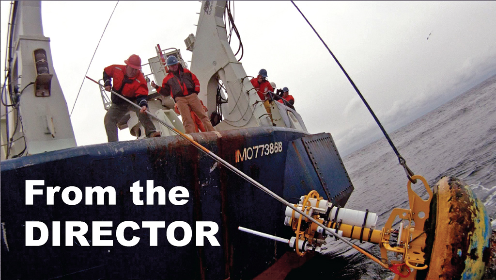
Letter from the Director
OOI User Community and Colleagues,
As leaves begin to change here in DC we have teed up a Fall Newsletter. We have had LOTS of other activities occurring over the past few months which kept our staff here at the Program Management Office (PMO) and university teams very busy.
Let’s start with a brief update on the status of the pending transition of OOI program management (see 2016 NSF RFP). Executive Summary: it’s still “pending.” The Consortium for Ocean Leadership (COL), the current awardee, did not re-compete for the award, so it will transition to a new awardee following selection by the NSF and National Science Board. This process is expected to complete in late Spring or early Summer 2018, with the transition to a new management team in Oct. 2018. In the meantime, COL has agreed to extend our management through Sept. 2018.
During this transition period the NSF has also approved the standup of a new range of tasks within the PMO. The first focuses on OOI Community Engagement. The PMO has established a new co-PI, Kristen Yarincik, to coordinate these emerging efforts and are advertising for a Senior Program Specialist position.
Secondly, we have created the new position of OOI Data Integrator, formally starting Jan. 2018. The OOI Data Integrator will directly report to me and be charged with coordinating our overall Cyber Infrastructure (CI) to ensure we are making the best use of our collective resources to maximize dissemination of data to you, our user community. We remain committed to ensuring that we are providing our user community with as much data as we can, as rapidly as we can, and that we remain responsive to your needs and input. I am confident that this new Data Integrator position will accelerate and sharpen our ongoing efforts to continually improve in this, our primary priority.
In September I enjoyed yet another opportunity to join a team from Rutgers and take OOI “on the road.” Team OOI manned a booth and ran a Town Hall meeting at the Oceans ’17 conference in Anchorage, AK. We continue to take advantage of every opportunity to share OOI with the broadest possible audience. In fact, we look forward to seeing you all in a few months at the Ocean Sciences Meeting in Portland, OR.
As always, I’d like to stress the importance we place on receiving feedback from you about our user interface and our data discovery, delivery, and display capabilities. Your feedback is the best and most rapid way we can identify shortfalls and enhance these capabilities. Please drop us a line and let us know about any problems or recommendations. Your inputs are vital, and they do drive our priorities!
Greg
SCIENCE HIGHLIGHTS
Global Array Provides Critical Weather Forecast Data
Global Southern Ocean Array data were recently integrated into the World Meteorological Organization’s (WMO) Global Telecommunication System. These data are being used by forecasters at European Centre for Medium-Range Weather Forecasts (ECMWF) to examine storms in the Southern Ocean as part of the Year of Polar Prediction Effort by the WMO. [Full Story]
New Computer Vision Routine Developed for CAMHD Video
A new computer vision routine, developed by Aaron Marburg at UW-APL and aided by Tim Crone at LDEO and Friedrich Knuth at Rutgers, is now able to correctly identify and tag scenes of scientific interest in the CAMHD video stream. [Full Story]
Endurance Array Captures Total Eclipse
On August 21, the path of totality of the “Eclipse Across America” passed directly over two OOI Coastal Endurance Array Surface Moorings, adjacent to one, and close to three others. These moorings were able “see” the eclipse minutes before it is seen from the mainland and examine it’s impact on the coastal ecosystem.
[Full Story] [LA Times Article]
INFRASTRUCTURE UPDATES
Irminger Sea Mooring Stopped Communications
On 12 October, 2017, the Surface Buoy on the OOI Global Irminger Sea Array Surface Mooring stopped all communications. There was no indication as to what may have caused the outage, and the current state of the buoy and mooring infrastructure was not known. [Full Story]
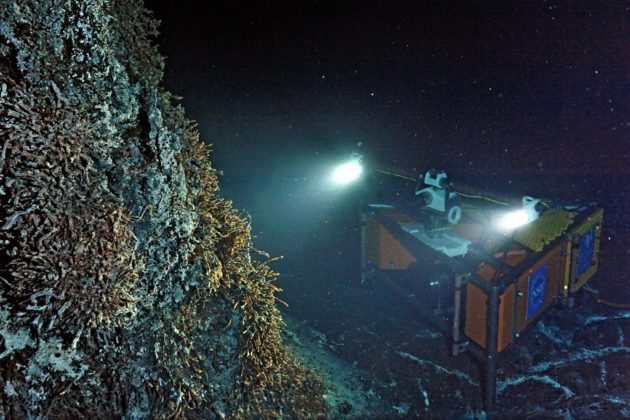
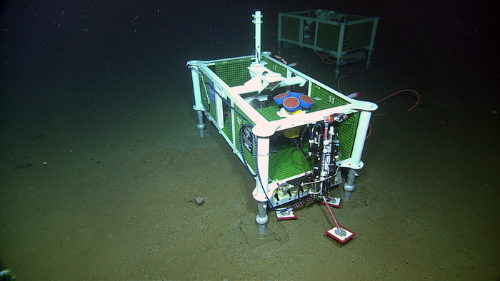
Endurance Array Oregon Offshore Cabled Shallow Profiler Mooring Disabled
On 16 September 2017 the Endurance Array Oregon Offshore Cabled Shallow Profiler Mooring was accidentally pulled off position and apparently damaged by fishing trawler gear. Communications to shore ceased. [Full Story]
Deployments Suspended at S. Hemisphere Arrays
NSF has instructed COL to develop and implement a plan for removal without replacement of the OOI global array moorings at 55 South latitude (Pacific) and the Argentine Basin (South Atlantic) during the scheduled Fall 2017 cruises. [Full Story]
DATA UPDATES
Over the last several months, a series of software updates have been successfully completed by the OOI Cyberinfrastructure team. Most noticeable is the addition of the OOI ERDDAP Server now online hosting uncabled telemetered data from OOI moorings and gliders. Additionally, the last three months have seen a surge in overall data availability following the successful introduction of new data ingestion capabilities in the OOI CI which have allowed our Data Team to improve data availability for our deployed sensors and instruments and accelerate ingest of archived and legacy datasets. For a full list of updates visit – https://ooinet.oceanobservatories.org/help
The OOI Data Team also continues to update the Community Tools page to include tools for quality control and testing as well as data download and plotting tools. Most recently, the Axial Seamount Earthquake Catalog (courtesy of Dr. William Wilcock, UW) was added. This catalog provides a near-real time catalog of earthquake detections and HYPOINVERSE locations for the OOI Cabled Array at Axial Seamount.
We are constantly making updates to our data services, including the data portal and Erddap server, based on user feedback. As always, if you have any suggestions or run into any issues, place contact the HelpDesk.
CRUISE UPDATES
During late Spring, Summer, and early Fall of 2017 our hard-working teams at WHOI, OSU, and UW completed both the Spring and Fall cruise for the Endurance and Pioneer arrays, the annual deployments to our global stations at Irminger Sea and Station Papa, and the annual maintenance cruise on the Cabled Array. Later this month Team WHOI will commence our operationally challenging annual deployments to our two high latitude Southern Ocean stations. Please note that these upcoming cruises will be “retrieve only,” following the decision to suspend deployments at these sites.
Read MoreUPDATE: Irminger Sea Surface Mooring Flyover Conducted
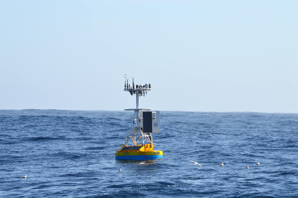
On 12 October, 2017, the Surface Buoy on the OOI Global Irminger Sea Array Surface Mooring stopped all communications. There remains no indication as to what may have caused the outage.
On 26 October an aerial survey and broad area search was conducted at the Irminger Sea Surface Buoy site and surrounding areas. The surface mooring was not sighted.
The next OOI Maintenance Cruise to the area is scheduled for June 2018. At which time a new Surface Mooring will be deployed.
Read MoreNew Community Tool – Near Real Time Earthquake Catalog
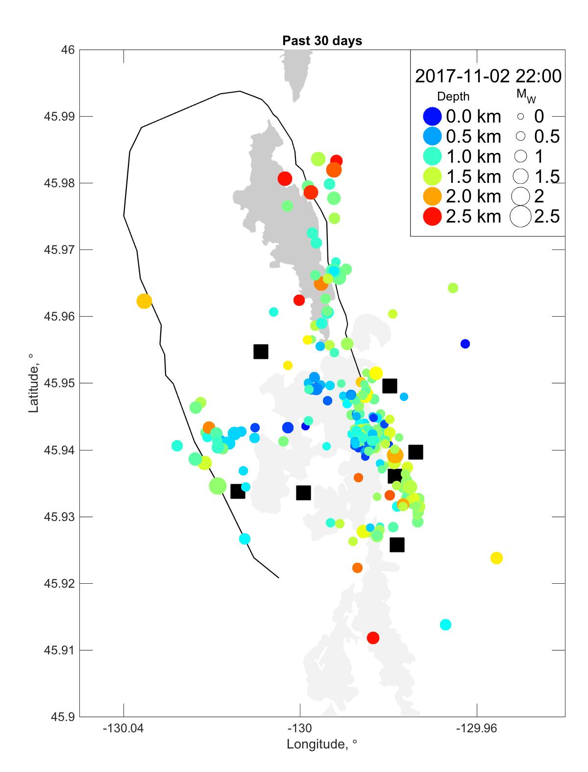
The OOI Cabled Array spans the Juan de Fuca tectonic plate in the NE Pacific, enabling monitoring of submarine earthquakes as well as volcanic activity, methane seeps, and water column processes. Seismometers installed at the Axial Seamount site focus on recording local earthquakes associated with volcanic eruptions, magma recharge and inflation of the summit caldera, tectonic extension, and hydrothermal circulation. Additionally, these seismometers are able to record regional and teleseismic earthquakes.
The Earthquake Catalog provides access to a near-real time catalog (updated hourly) of local earthquake detections and HYPOINVERSE locations for these seismometers. Along with the catalog of events, the site features maps of earthquake activity on 24-hour, 7-day, and 30-day intervals, as well as histogram plots of recent activity put into context with historic eruptions at Axial.
Support for this work comes from the National Science Foundation.
Check out the Community Tools page for more great tools and derived datasets created by our users. Do you have a tool& or database you created to work with OOI data that you would like share on the OOI Website? Contact the HelpDesk and let us know!
Read More