
Posts by ooistaff
R/V Oceanus Remembered as a Workhorse of the U.S. Academic Research Fleet
The long service of the R/V Oceanus (1976-2021) came to end on November 21, 2021 as the ship pulled into port after having successfully completed its last interdisciplinary cruise for Oregon State University (OSU). The Oceanus began its 45-year-run of scientific investigations at Woods Hole Oceanographic Institution (WHOI) in 1976. After a major mid-life refit, the ship was transferred to OSU in 2012, and contributed to the Ocean Observatories Initiative (OOI) off both coasts.
“The Oceanus proved to be a real workhorse for the Academic Research Fleet and also played a pivotal role for the OOI during its initial launch,” said Ed Dever, PI of OOI’s Coastal Endurance Array, who sailed on the ship many times. “While at WHOI, The Oceanus performed some of OOI’s at-sea-mooring test deployments and later the ship was used for the initial deployment of the Coastal Endurance Array off the Oregon coast.”
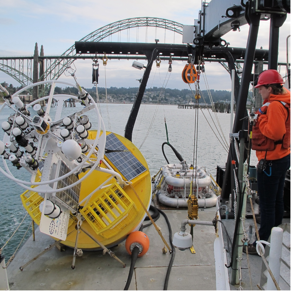
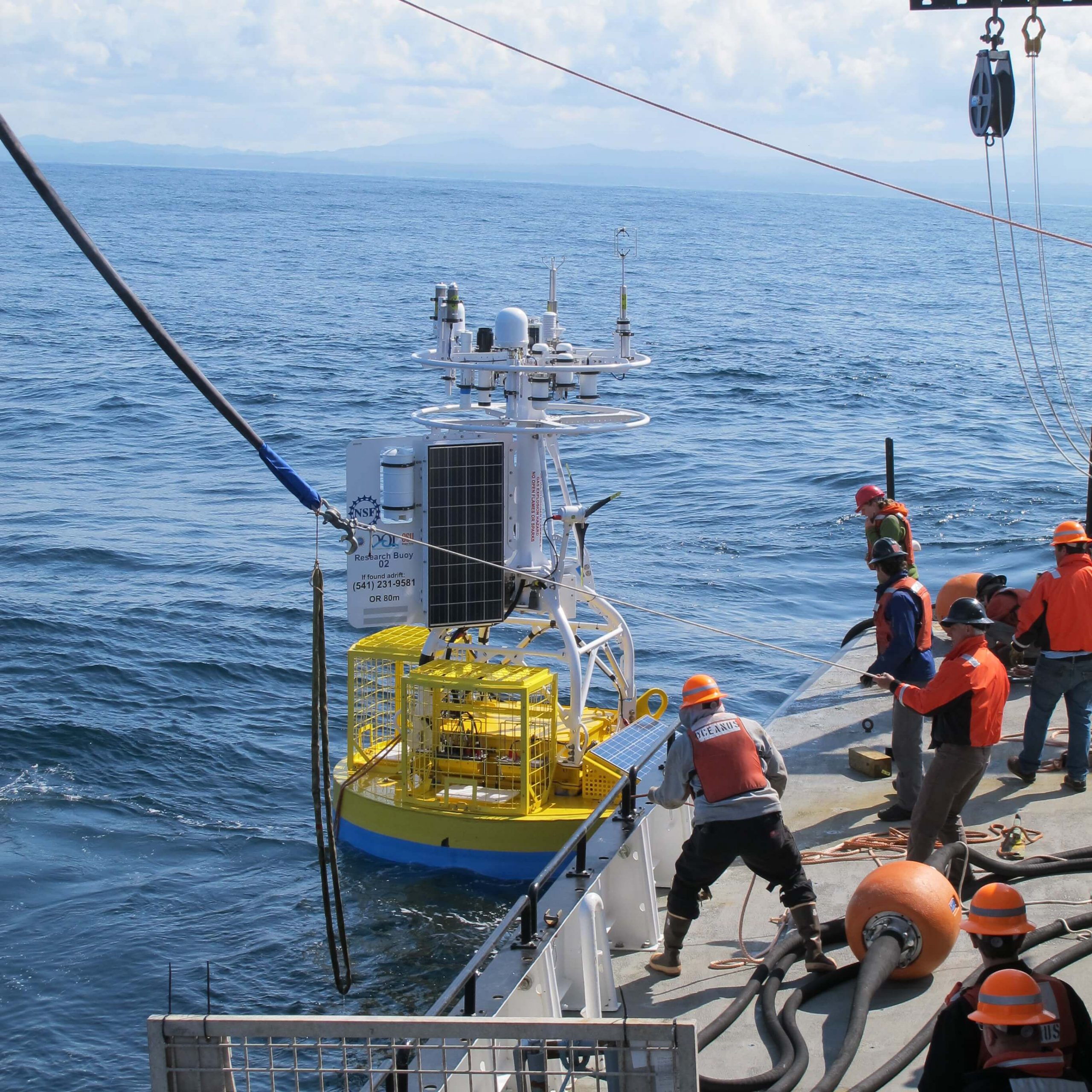
In spring and fall 2014, after moving to OSU, Oceanus performed the initial deployments of the Oregon and Washington inshore moorings and Washington profiler mooring. The real test for the Oceanus, however, came during 2015, when it was tasked with deploying the full scope of the Endurance Array, including the four large coastal surface moorings at the Oregon and Washington shelf and offshore sites.
Explained Dever, “Thanks to some excellent ship handling, care on the part of the deck crew and a huge assist from some very kind weather, we got the moorings safely in the water using the ship’s crane to deploy the 10,000-pound buoy off the starboard fantail and the heavy lift winch to deploy the 11,000-pound multifunction node (MFN, bottom lander) through the A-frame. The size of the buoys and MFNs meant that Oceanus could only carry one buoy out at a time and the cruise was completed in five legs with some very efficient port stops. By the end of the cruise, it was evident that we would need to move future operations to global and oceans class ships and after one more deployment in fall 2015 (with recoveries carried out on the R/V Thomas G. Thompson), we made that transition.”
[embed]https://youtu.be/pDRagMTDUTk[/embed]After the initial Endurance Array deployments, OOI transitioned to using larger global and oceans class ships needed to recover the bulky coastal surface moorings, with one exception. In spring 2019, with tight schedules on global class ships, UNOLS (University-National Oceanographic Laboratory System charged with ship scheduling) requested that OOI Endurance split the spring mooring recovery and deployment cruise between the R/V Sikuliaq and the R/V Oceanus. The Oceanus ably performed the profiler mooring deployment, anchor recoveries, coastal surface piercing profiler deployments, and glider deployments over five days in April and May 2019.
While not directly working with the OOI, the Oceanus continued to work off Oregon at and around the OOI arrays. Research and student cruises often sampled over the years near OOI’s Endurance and RCA Arrays at the Oregon inshore, shelf, offshore and Hydrate Ridge sites to compare shipboard measurements and OOI time series. This work included CTD profiles, net tows, coring, and sediment trap deployments.
The last Oceanus cruise, in fact, was one such interdisciplinary research cruise led by OSU researcher Clare Reimers, who also served as chief scientist. During its final official outing, the team aboard the Oceanus sampled the outer shelf at the northern end of Heceta Bank, Oregon to help scientists determine any changes that may have occurred to a swath of the margin that was reopened to commercial bottom trawling in 2020 after an 18-year closure. Reimers said, “The R/V Oceanus and crew performed flawlessly, and our science mission was fully completed.”
Added Dever, “What better way to end its long and illustrious career? We at OOI join many others in appreciation of the R/V Oceanus, and the dedication and skills of all who sailed on her and supported ocean science throughout her many years at sea.”
______________________________________________________________________________________
Special thanks to OOI Data Center Project Manager Craig Risien for sharing the GoPro time lapse of the loading of the Oregon Offshore mooring onto the R/V Oceanus in spring 2015.
Read MoreMarine Mammal Operations Aboard R/V Neil Armstrong During Pioneer 17
The Northeast Fisheries Science Center (NEFSC) had the opportunity to participate on leg two of the Pioneer Array research cruise aboard the R/V Neil Armstrong. The dates for the second leg this year were November 7 – 15 2021. This time frame was critical for us because our main asset for assessing right whale distribution, the NOAA (National Oceanic and Atmospheric Administration)Twin Otter aircraft was scheduled to depart for the Gulf of St. Lawrence Canada, and would not be available. Since 2010 the distribution of the North Atlantic Right whale has changed significantly, and it has become increasingly important to survey more broadly within the range to determine if there are aggregations of right whales in unprotected areas.
Participating scientists from the NEFSC for this cruise were Chris Tremblay and myself, Pete Duley. Chris was brought on for his expertise in acoustics, specifically with the deployment and monitoring of sonobuoys for the detection of North Atlantic Right whales and other large baleen whales. This additional element to our research plan was added to detect right whales in weather when visual observations were not ideal, and to access call types associated with different behaviors from observations with right whales in good visual conditions. Deployment of sonobuoys were conducted with very low or no impact to the mission of the work on the Pioneer array. November 12 was the only day of the entire cruise in which we were unable to conduct visual observations due to the weather. The Northeast U.S Shelf Long Term Ecological Research (NES-LTER) group was conducting a CTD survey across the shelf break and we used this opportunity to make four sonobuoy drops in association with their survey. We are still analyzing the acoustic recordings form the cruise, but at this point feel that they were a valuable addition to the research.
Sonobuoys are launched by hand from the back deck, once permission has been granted by the bridge. The instruments are not meant to be retrieved and can record for up to eight hours. The instruments send information from their hydrophones by VHF transmission (line of sight) to an antenna mounted on one of the upper decks (01), and scuttle themselves after eight hours of recording.
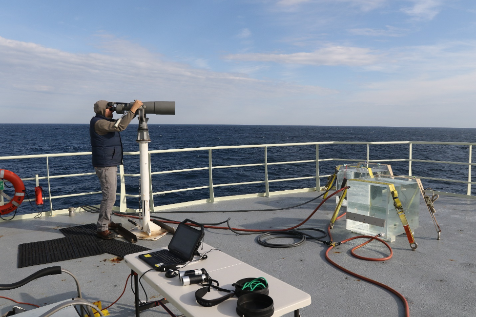
[media-caption path="/wp-content/uploads/2021/11/Bigeyes.png" link="#"]Marine Mammal Observer Chris Tremblay uses Bigeye binoculars to search for right whales during mooring operations by the Pioneer 17 team. Credit: Peter Duley. [/media-caption]
Marine mammal visual operations aboard the Neil Armstrong were conducted from the 01 Deck. Our Bigeye stand would not fit the predrilled holes in the 01 deck and this required Kyle Covert, the ship’s welder, to manufacture some iron fasteners to secure the stand and Bigeye binoculars. This issue was fixed during the staging prior to our departure and worked quite well. The marine mammal observation deck (deck 02) was unavailable to us this year because of Bigeye stand mounting issues. There are plates welded into the deck for the stands, but no predrilled bolt pattern in the deck. The marine mammal deck also has a desk with access to the ship’s SCS (Sea Control Ship) feed, and offers a better vantage point because it is higher. However, even while working in higher sea states we were unaffected by spray from the bow on the 01 deck, and this worked out quite well for this cruise. We brought with us a small desk, some deck chairs, and ratchet straps for securing everything.
The crane on the 01 deck is on the starboard side and caused a slight visual obstruction in panning from 090 to 270 degrees. The location of the Bigeyes aft on the port side, however, provided good visibility nearly to 180 degrees on the port side, which proved useful when stationary during the Pioneer Array mooring deployments and recoveries. We recorded whales aft of the ship during several of these stationary observation periods. Visual observations while underway were conducted from 07:30 to 16:45 and observers rotated from the Bigeyes to the recorder position on the half hour. At the locations where the ship was stationary working on mooring operations for extended periods of time, Chris and I did a scan of the area every 15 minutes. We are still working on analyses of the visual data, and although we did not observe any right whales during the Pioneer 17 cruise we feel that the ship is a great asset for our work and would love for the collaborative effort to continue. Thank you so much for the opportunity to participate this year!
Written by Peter Duley, Fisheries Wildlife Biologist, Northeast Fisheries Science Center
Read MoreWorkshop: OOI Data in Project EDDIE Materials
Project EDDIE and the SERC (Science Education Resource Center at Carleton College) have an exciting workshop coming up that you won’t want to miss! It offers opportunities to build teaching modules using OOI data.
The Project EDDIE Module Development & Community Building Experience will be held online via Zoom as half-day meetings on January 20, 27, and February 10. This workshop will facilitate participants developing teaching modules that pair scientific concepts and quantitative reasoning with teaching with data. The teaching modules follow a tested design rubric developed by Project EDDIE and resulting materials will be published as part of a growing collection of modules.
During the workshop, participants will construct a 1-day module that uses an openly available dataset for a specific ecology, limnology, geology, hydrology, oceanography or environmental science course. Each module will focus on a scientific concept and address a set of quantitative reasoning or analytical skills using large, openly available datasets, such as OOI, following the Project EDDIE module structure. Interactive peer review and module share out meetings following the workshop will help improve developed materials before you pilot them.
Participants will be expected to 1) attend the workshop and develop a module 2)attend one virtual peer review and one module share out and planning session 3) teach and revise their materials, 4) and make revisions from the peer review and an external review before publishing. Final modules will be published online by December 2022. Participants will be provided a $1,500 stipend for completing, testing, and publishing their module.
This workshop also provides special opportunities to:
- Understand how working with large datasets improves quantitative reasoning in students
- Incorporate your module into your syllabus/course schedule and develop an assessment plan
- Meet new people who share similar interests in teaching and working with data
There is no registration cost for attending this meeting. The successful completion and testing of a module includes up to a $1,500 stipend. Successful completion of the modules includes authoring, piloting, revising, and publishing the teaching and supporting materials.
The application deadline for this workshop is November 28, 2021. Apply now. Conveners are actively seeking modules focused on OOI data.
Read More
Student and Early Career Travel Funds Available: Apply Now!
Do you need travel funds to attend and present your OOI research at a conference?
If you need funding to offset conference expenses (registration fees, travel costs, accommodations, etc.), we encourage you to apply. Conference participation can be in-person or virtual. With the Fall AGU and Ocean Science Meetings approaching, we wanted to remind you of this opportunity.
Endurance Array to Provide Hourly Meteorological Data
On 11 October 2021, the National Oceanic and Atmospheric Administration (NOAA)requested that OOI’s Coastal Endurance Array buoys provide hourly meteorological data to the National Data Buoy Center (NDBC) because a nearby NDBC buoy (46029, Columbia River bar) had gone offline. OOI buoy data are typically telemetered every two hours due to sampling schedule and bandwidth constraints (the actual sampling rate is higher).
Endurance Array team members examined sampling and telemetry schedules for the Endurance offshore coastal surface moorings to see if they could accommodate NOAA’s request. The team concluded that meteorological data from the moorings could be updated hourly while still meeting OOI sampling requirements.
“To help ensure continuity of data to the NDBC, we plan to distribute hourly meteorological data from the Endurance Array Oregon and Washington offshore sites for the duration of the outage at NBDC 46029,” said Edward Dever, lead of the Coastal Endurance Team. “We’re pleased to respond to NOAA’s request and hope these data prove useful to operational weather forecasts and marine safety.” The Oregon and Washington offshore sites have NDBC buoys designations of 46098 and 46100, respectively.
The Endurance Array team will continue to review the performance of the buoys and ensure the updated telemetry schedule does not impact OOI sampling. If data users do experience any impacts from this change in sampling frequency, please contact Jon Fram at Jonathan.Fram@oregonstate.edu.
Read MoreOcean Data Lab Nuggets Providing Foundation for Accessible Oceans
Example of Integrated Ocean Observing System
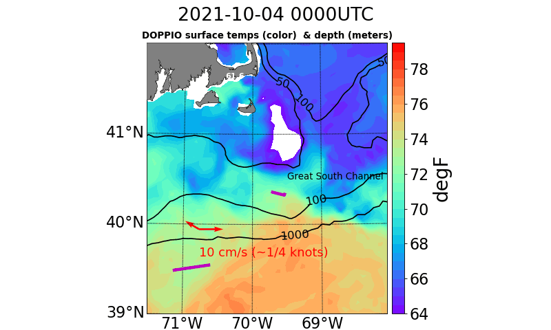
The potential of sharing ocean observations to determine ocean conditions in real-time was highlighted in last week’s update of the Environmental Monitors on Lobster Traps and Large Trawlers (eMOLT) project. EMOLT is a non-profit collaboration of industry, science, and academics focusing on monitoring the physical environment of the Gulf of Maine and Southern New England shelf.

Explained in the update, observers at the National Oceanic and Atmospheric Administration (NOAA) were watching oceanographic activity at the Southern New England shelf edge as a warm core ring impinged on an area south of Nantucket. As shown by the purple worm in the animation above a drifter (deployed off F/V Lady Rebecca back in June on Jeffreys Ledge) had drifted near the Great South Channel and seemed confused on which way to go. After traveling along a fairly normal track, it had been affected by “eddies off eddies, off eddies.” Earlier last week, a sensor-laden Central Falls, RI, High School miniboat, deployed by the University of Rhode Island’s R/V Endeavor, was entrained in the outer fringes of the actual Gulf Stream ring.The NOAA team used Ocean Observatories Initiative (OOI) moorings, which are just downstream of this area, to explore multiple variables throughout the water column to get a better idea of ocean conditions that aligned with the drifter’s movements. The animation also shows the current velocity (red arrow) near 400 meters as reported by OOI’s moored profiling instrument.
Read MoreRide Along with Pioneer 17
After a three-day weather delay, on Friday 29 October, the 14-member Pioneer Array science party will board the R/V Neil Armstrong in Woods Hole, MA and head toward the array, 75 nautical miles south of Martha’s Vineyard. The team will recover and deploy moorings and instrumentation to keep the array operational, collecting and sending data back to shore.
What’s novel about this mission is not only is it the 17th time the array will have been “turned,” but this time, you can follow along. Bookmark this link for regular updates of progress, conditions, and life at sea. The team promises a good ride along.
Read MoreNew Underwater Camera with Off-the-Shelf Components
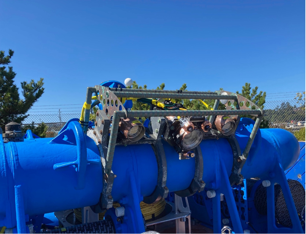
In September 2021, the Coastal Endurance Array began rolling out a much-needed upgrade to their underwater cameras. Endurance Array Innovator Chris Holm engineered a camera using off-the-shelf components to meet the specific needs of capturing environmental conditions and marine life in proximity to the Endurance Array moorings. The prototype was put in place on the inshore mooring (CE01) during the 15th turn of the Coastal Endurance Array.
[media-caption path="https://oceanobservatories.org/wp-content/uploads/2021/10/camera.png" link="#"]The newly configured Endurance Array underwater camera is attached to the inshore mooring, ready for deployment. Photo: Chris Holm, OSU.[/media-caption]The innovation came in multiple steps. Holm first tried to salvage the camera’s hardware and reprogram the camera with new software. He hit a snag, however, in that the motherboard that controlled the camera was no longer supported.
Since it didn’t make sense to rebuild the camera using an out-of-date motherboard, Holm looked into finding a new camera on the market. It had to be suitable for use underwater, with the capability to go into a low-power mode. “What is really needed for low-light conditions underwater is a camera with a large physical sensor, but with fewer megapixels,” explained Holm.
“Since the moorings run on battery power, the cameras need to be able to go into a very low-power sleep state in between taking photos,” said Holm. “If the sleep current is high, the deployment life is low. So, we were trying to find an off-the-shelf solution for a way to go into low power.”
After some searching, Holm obtained a Raspberry Pi High Quality Camera. Although the Raspberry Pi doesn’t come with native power management capabilities, Holm found he could use Sleepy Pi, an add-on-board from Spell Foundry that can power the Raspberry Pi on and off.
For its launch, the camera is programmed to autonomously take a burst of three images every four hours. The system can also take photos when triggered by a Data Concentration Logger (DCL) and can be partially configured remotely. Future iterations will be fully configurable remotely via the DCL.
The final touch to this first iteration was figuring out how to turn the lights and lasers on and off. Holm used a relay board from Waveshare Electronics to power the original systems lights and lasers. The lights adjust their brightness depending on the voltage being sent through a signal line which is controlled by the GPIO pins of the Raspberry Pi.
Altogether, the system is very suitable for the Endurance Array’s needs and is an extremely cost-effective, off-the-shelf solution. The cameras also can be easily swapped out if the Endurance team decides to upgrade the cameras.
Since this newly configured camera was put in place in early September, Holm said, it has been performing flawlessly, with the auto-exposure working well. Since this mooring uses a cell modem to transmit data, the team has been able to see the photos the camera is taking in near real-time. Once the formal approval process for the camera’s integration and use across the OOI is completed, Holm will be building more camera systems for the Endurance Array to deploy on the offshore and shelf moorings during the spring.
Since the cameras and its settings can be upgraded and/or optimized for different use cases, depending on what an investigator is interested in (such as marine snow or benthic organisms), Holm would like to hear from scientists about what they’d like the camera to focus on. He created a survey for data users interested in the underwater cameras.
“It would be very helpful to know what kind of data would be most useful to scientists using the system,” he said.
For those interested in seeing underwater, please complete the survey here.
[media-caption path="https://oceanobservatories.org/wp-content/uploads/2021/10/camera-output.png" link="#"]The Endurance Array team has the capability to adjust the settings of the underwater cameras based on researchers’ interests. In addition, some post-processing tools could be developed to sort images or extract useful information from them. Photo: Chris Holm, OSU.[/media-caption]
Read More
NERACOOS Makes Case for Ocean Observations
In an editorial opinion piece that ran in the Cape Cod Times and The Maritime Executive, Jake Kritzer, Executive Director of OOI’s partner organization Northeastern Regional Association of Coastal Ocean Observing Systems (NERACOOS), clearly and succinctly laid out the case for why ocean observing systems are so important and worthy of federal support. “Ocean infrastructure generates information that underpins our maritime economy, supporting navigation, safety and coastal resilience. We’re talking about the lighthouses of the 21st century.”
OOI data from the Pioneer Array are accessible on NERACOOS’ Mariner’s Dashboard, helping to provide a better picture of both current and long-term conditions on the New England Shelf. Together, this network of ocean observing systems is working to improve forecasting, enhance mariner’s safety, and ultimately helping to advance scientific understanding of ocean processes.
Read More