
News
Update: Winter 2017 Staff Consultations
Upcoming Coastal and Global Arrays Webinar
The CGSN and EA teams will host a Webinar Tues. Jan. 17, 2017 at 4:00 pm ET to present an overview of the Coastal Pioneer, uncabled Coastal Endurance and Global Array designs. This will include the configuration of the Arrays, descriptions of the various platforms, and engineering details including power, communications, etc. An opportunity to answer questions will also be available. The session is scheduled to last up to 1.5 hours.
[button link="https://docs.google.com/forms/d/e/1FAIpQLSfVe2gmnCbJ1CSn0aNP_HkGMbXU4mf5ONZbjh5gGj18RT9shw/viewform" bg_color="#00a9dd" window="yes"]Register Here[/button]
Please RSVP by Jan. 13
Cabled Array Webinar Recording and Presentation Posted
The presentation and recording of last weeks Cabled Array have now been posted.
Investigators interested in the Cabled Array can also schedule a one-one-one meeting to discuss their proposed plans and to learn more about the capabilities of the Cabled Array infrastructure. If you are interested in setting up a meeting, please send an email to ooicable@uw.edu.
Read MoreNSF Announcement: OOI Facility Board
The Division of Ocean Sciences (OCE) of the National Science Foundation (NSF) requests nominations, including self-nominations, for inaugural Members to serve on the newly established “Ocean Observatories Initiative Facility Board” (OOIFB). The OOIFB will provide independent input and guidance regarding the management and operation of the Ocean Observatories Initiative (OOI). All such input and guidance will be communicated both to the OOI Operator and NSF.
The Dear Colleague Letter (NSF 17-034) announcing this opportunity may be found here…
https://www.nsf.gov/pubs/2017/nsf17034/nsf17034.jsp
…and includes links to the “Terms of Reference of the OOIFB”, which may also be found here…
https://www.nsf.gov/geo/oce/programs/ooi/ooifb-tor.jsp
Read More2016 AGU Fall Meeting OOI Town Hall
DEADLINE EXTENDED – We will be accepting one slide submission until Thurs. 12/8. We look forward to seeing each of you at the upcoming 2016 AGU Fall Meeting in San Francisco, CA. The OOI will be hosting a town hall Tues. Dec. 13, from 6:15-7:15 PM in Moscone West Room 2008.
Read MoreManagement and Operation of the Ocean Observatories Initiative (OOI)
The Division of Ocean Sciences (OCE) of the National Science Foundation (NSF) has recently announced a solicitation (NSF 17-524) that seeks the services of a qualified organization to provide scientific and technical management and operation of the Ocean Observatories Initiative (OOI).
Read MoreOOI Endurance Array team sets sail on fall O&M cruise
On Sunday Sept. 18, the R/V Atlantis set sail off the coast of Oregon and Washington for a 17-day Operations and Maintenance cruise of the OOI Coastal Endurance Array. During this cruise, the OOI team led by Oregon State University (OSU) will recover and redeploy six surface moorings as well as the Washington Offshore Profiler Mooring and several uncabled surface piercing profilers. The team will also recover 1 coastal glider and deploy 5-6 more.
Biannual maintenance cruises are an important element of OOI Coastal Array operation and maintenance as it ensures that infrastructure and instrumentation in the ocean are constantly replaced before they break and are refreshed to minimize the influence of bio-fouling and sensor drift. The coastal ocean is a harsh environment; equipment are constantly blasted by sand and debris and beaten by waves. Additionally, full, high resolution, data sets are able to be downloaded from the recovered instrumentation, increasing the data available from the telemetered near-real time data sent to shore via satellite.
The OSU-team has been hard at work to prepare the OOI equipment for deployment. A time-lapse video (below) shows a mere 10 days of that effort as they integrate mooring elements and prepare to place these equipment out to sea for six-months.
[media type="video" path="https://www.youtube.com/watch?v=PKR8z10zKwM&feature=youtu.be" link="#"][/media] Read MoreOOI scientists and Data Team to present at MTS/IEEE Oceans 16 Meeting
Scientists and engineers from the OOI Marine Implementing Organizations (MIOs) and the OOI Data Team are gearing up to present at the 2016 MTS/IEEE Oceans conference in Monterey Bay, CA September 19 – 22, 2016.
The event is set to draw an international audience of more than 2,000 attendees. The conference will center around presentations and posters from over 500 professionally reviewed technical papers, including those submitted by OOI scientists and engineers.
We look forward to connecting with you all at the conference.
OOI Related Presentations
Tuesday Sept. 20
1:30-3:00, Marriott: San Francisco
- Wilcock, W.D.S., D.A. Schmidt, J.E. Vidale, M.J. Harrington, P. Boudin, et al. Designing an Offshore Geophysical Network in the Pacific Northwest for Earthquake and Tsunami Early Warning and Hazard Research
Manalang, D., and J.R. Delaney. Axial Seamount – Restless, Wired and Occupied: A Conceptual overview of Resident AUV Operations and Technologies.
Kelley, D.S., J.R. Delaney, and the Cabled Array Team. NSF’s Cabled Array: A Wired Tectonic Plate and Overlying Ocean
5:30-5:00, Marriott: San Francisco
- McRae, E. Continuous Real Time Scanning of the Upper Ocean Water Column.
Wednesday Sept. 21
10:30-12:00, Portola: Cotton Wood 2
- Philip, B.T., D.S. Kelley, E.A.Solomon, and J.R. Delaney. Monitoring Methane Emissions at Southern Hydrate Ridge using an OOI Cabled Array Acoustic Doppler Current Profiler.
1:30-3:00, Marriott: Santa Barbara
- Delaney, J.R., D.S. Kelley, A. Marburg, M. Stoermer, H. Hadaway, K. Juniper, and F. Knuth. Axial Seamount – Wired and Restless: A Cabled Submarine Network Enables Real-time tracking of a Mid-Ocean Ridge Eruption and Live Video of an Active Hydrothermal System Juan de Fuca Ridge, NE Pacific
Thursday Sept. 22
8:30-10:00, Marriott: Santa Barbara
- Marburg, A., and K. Bigham. Deep Learning for Benthic Fauna Identification
10:30-12:00, Portola: Cotton Wood 2
- Knuth, F., L. Belabassi, L. Garizio, M. Smith, M. Vardaro, and A. Marburg. Automated QA/QC and Time Series Analyses on OOI High-Definition Video Data
Belabbassi, L., L. Garzio, M. Smith, F. Knuth, J. Kerfoot, M. Vardaro, and M. Crowley. Successes and Lessons Learned from OOI End-to-End System Data Quality Audit
Two years of Pioneer Gliders: A track line view
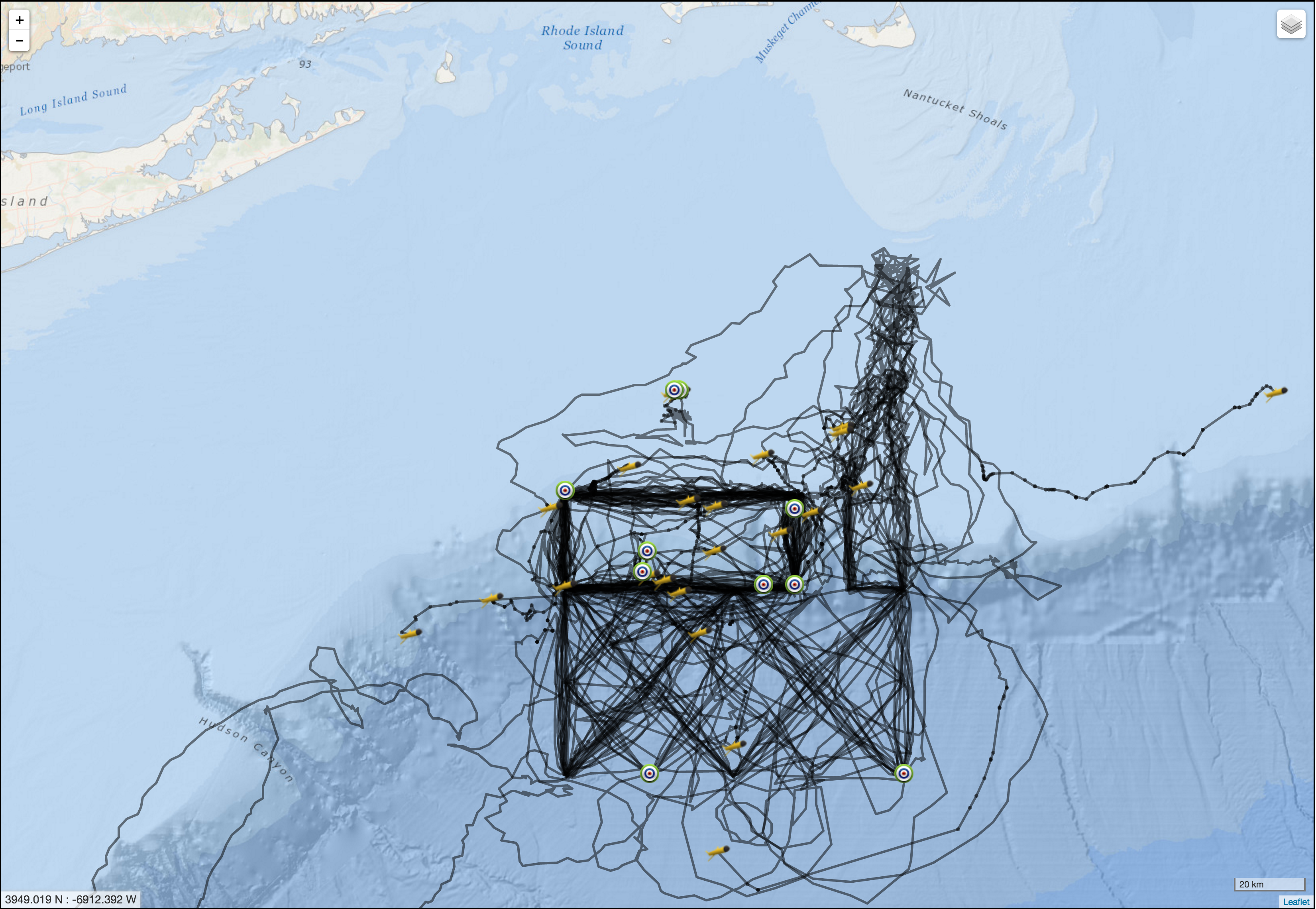
In July, the OOI CGSN operations team completed another “refresh” of the Pioneer glider fleet. The nominal lifetime for OOI coastal gliders (battery limited) is 90 days. The fleet is refreshed by recovery of exhausted gliders and deployment of refurbished gliders with fresh batteries.
The Coastal Pioneer Array is designed to have 6 Coastal Gliders deployed at a time. Each glider traverses a distinct path within and around the Pioneer Array, sampling an area measuring over 24,000 km2, roughly the size of New Hampshire.
The first three Pioneer Array Coastal Gliders were deployed just over two years ago in May 2014. The map on the right shows a composite of the tracks of all the gliders deployed at Pioneer since those initial deployments.
The impressive results of glider piloting in the complex coastal environment are evidenced by the match between the composite tracks (right) and the planned tracks (left). The tracks that diverge from the plan show the difficulty of maintaining the glider navigation in the face of severe weather and strong currents.
On average, each of the 25 gliders, for which data are shown, were deployed for a duration of 66 days and travelled a distances of approximately 1200 km (750 miles). The longest deployment was 118 days and the glider travelled a distance of 2,230 km (or 1,400 miles). That is roughly the same as driving halfway across the United States!
Congrats to the Pioneer team on a job well done. This is just the beginning!
[twocol_one][caption id="attachment_10832" align="alignright" width="276"]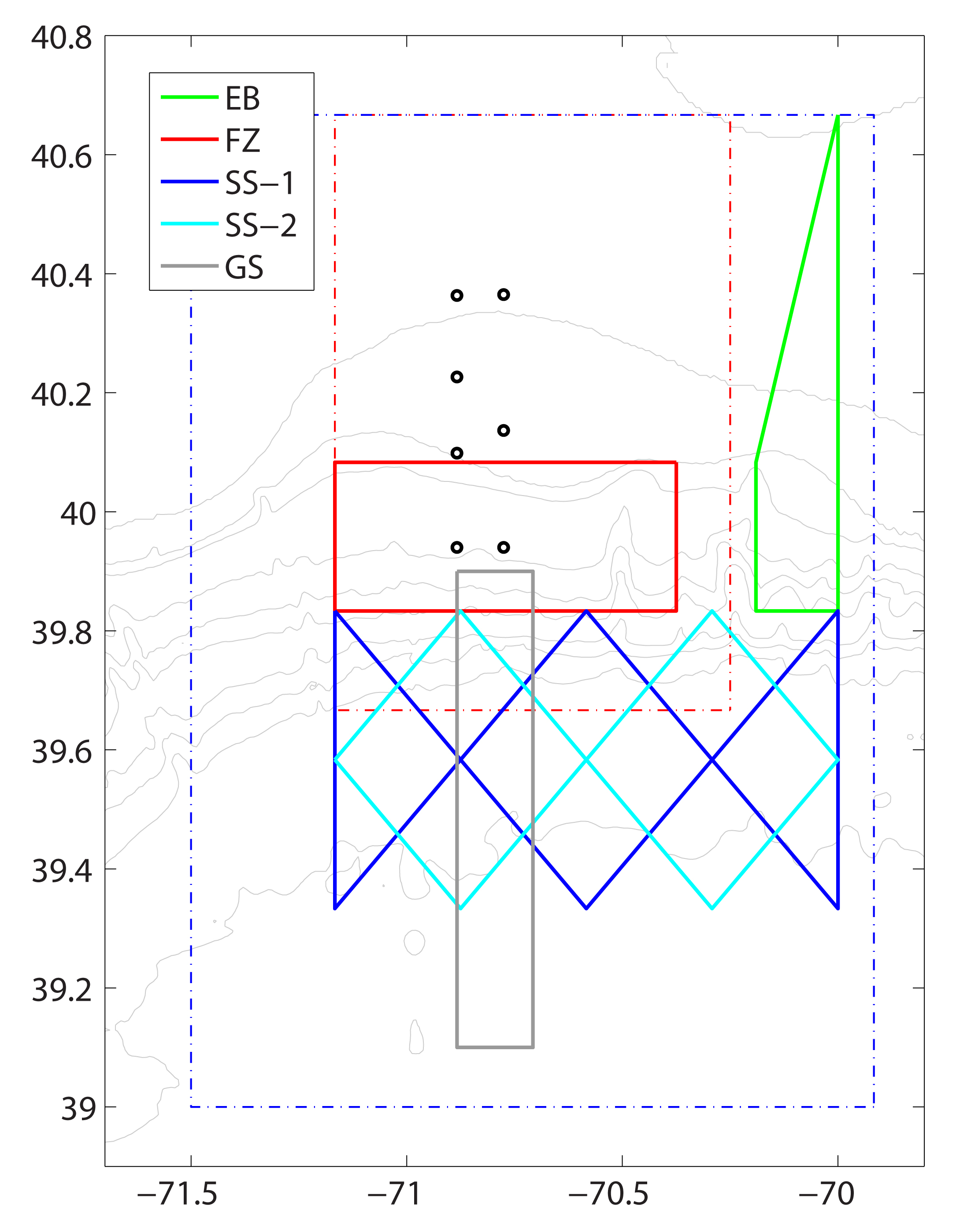 Pioneer Array gliders sample along five glider tracks off the coast of New England. The x- and y-axis are latitude and longitude in decimal degrees. Pioneer Array mooring sites are represented by circles. Boundaries of the glider and AUV operating areas are represented by the blue and red dashed lines, respectively. The five glider tracks are represented by the solid color lines:
-Eastern Boundary (EB) green
-Frontal Zone (FZ) red. Note: two gliders occupy this track
-Slope Sea: SS-1 blue; SS-2 cyan
-Gulf Stream (GS) gray[/caption]
[/twocol_one] [twocol_one_last]
[caption id="attachment_10715" align="aligncenter" width="507"] Each line represents the path of one glider. Glider symbols are the last location of the glider before recovery, green dots represent deployment locations.[/caption]
[/twocol_one_last] Read More
Observing the Oceans, a Photo Tour
Woods Hole Oceanographic Institution (WHOI), the Marine Implementing Organization for the OOI Coastal Pioneer and Global Arrays has created a photo tour of their journey with the OOI from the development and design of these arrays to the completion of construction.
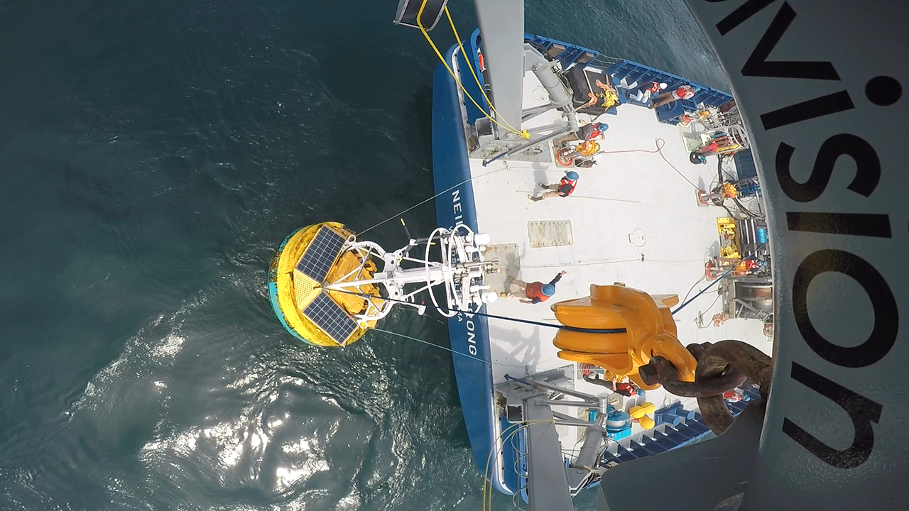
[media-caption type="image" path="/wp-content/uploads/2016/08/000_OOI_intro_GoPro_Armstrong_Paul_Matthias_435553.jpg" alt="The Ocean Observatories Initiative is moving full speed ahead at Woods Hole Oceanographic Institution." link="https://oceanobservatories.org/2016/08/observing-the-oceans-a-photo-tour/000_ooi_intro_gopro_armstrong_paul_matthias_435553"]The Ocean Observatories Initiative is moving full speed ahead at Woods Hole Oceanographic Institution. This unprecedented ocean science project is streaming a wealth of marine data straight from the ocean to the World Wide Web, making it free for anyone to use. In the image above, an OOI coastal surface buoy is recovered from the ocean and hoisted onto the fantail of the research vessel Neil Armstrong. Photo Credit: Paul Matthias, WHOI[/media-caption] [button link="http://www.whoi.edu/visualWHOI/observing-the-ocean"]Check it out![/button] Read MoreOOI data now available from NANOOS
Northwest Association of Networked Ocean Observing Systems (NANOOS) is now serving OOI data on their NANOOS Visualization System (NVS). Data from the OOI Coastal Endurance OR and WA Line Surface Moorings can now be viewed along side other sources including NANOOS, NSF CMOP, NOAA NDBC, and CDIP.
This effort marks the beginning of the larger effort to integrate OOI data into existing public data repositories to increase user access to these data and further facilitate interdisciplinary research by putting the OOI infrastructure in the context of other data available in the area.
Stay tuned as we continue to reach out to organizations, like IOOS, to cross post our data!
Interested in what else the community is up to with OOI data? Check out the Community Resources page on our website.
Read MoreVISIONS’16 OOI Cabled Array Maintenance Cruise Begins
On July 10, the R/V Sikuliaq left dock at the University of Washington to begin VISIONS’16, a 39-day mission to replace and maintain elements of the Cabled Array off the coasts of Oregon and Washington. Led by Chief Scientist Deb Kelley, this is the second Operations and Maintenance cruise for the Cabled Array implementing organization, as part of the National Science Foundation’s (NSF) Ocean Observatories Initiative.
During the cruise, scientists from the University of Washington School of Oceanography within the College of the Environment and engineers from the Applied Physics Laboratory will visit all of the Cabled Array sites where they will recover, install, and test over 100 instruments and nine junction boxes. They will also recover and reinstall the Deep Profiler Moorings at the Endurance Offshore and Slope Base sites. The remotely operated vehicle (ROV) Jason will also assist in the recovery and installation of the underwater infrastructure. This is Jason’s first time supporting the Cabled Array, which required special modifications to be made to the ROV over the past year.
The three legs of the cruise will run from July 10 to August 15, 2016.
You can learn more about the cruise on the VISIONS’16 website, which includes daily cruise logs, as well as image and video galleries. You can also follow along on Twitter (@VISIONSops), where up-to-the-minute updates about activities on board are posted.
Read More