
Posts Tagged ‘Coastal Pioneer Array’
Recovery of Pioneer Array in November
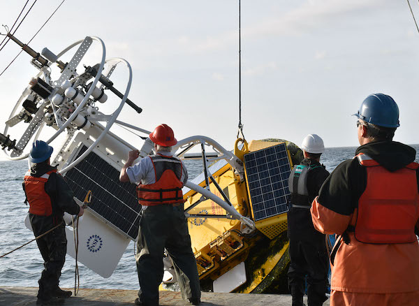
On November 9, 2022, a team of 18 scientists and engineers will leave the dock at Woods Hole, MA aboard the R/V Neil Armstrong on an historic expedition. It will be the nineteenth, and last, expedition to the Coastal Pioneer Array on the New England Shelf (NES). This is because the team will be recovering, but not redeploying the NES Pioneer array as in prior years. Designed to be relocatable, the array will be moved to a new location in theSouthern Mid-Atlantic Bight in early 2024. The ocean observing data collected since 2016 at the NES site, about 75 nautical miles south of Martha’s Vineyard, has provided valuable insights into changing ocean conditions at the Atlantic continental shelf and upper slope. The New England Shelf Pioneer data will remain available to the community for continued analysis.
“The Coastal Pioneer Array has been a true workhorse, providing valuable, consistent data from this important intersection in the ocean, where ocean currents meet in weather-like “fronts,” and where heat, salt, nutrients, and other properties are exchanged between the coast and the deep ocean “said Chief Scientist John Lund, who has been on 18 of Pioneer’s 19 expeditions.
“The impacts of the Coastal Pioneer Array have been many,” added Al Plueddemann, Principal Investigator of OOI Coastal and Global Scale Nodes. “To my knowledge, OOI Pioneer is the first sustained, interdisciplinary shelfbreak observatory. Pioneer data have allowed researchers to identify new shelf-slope dynamics and exchange mechanisms and have given us a first glimpse of what appears to be a changing coastal regime. It is very gratifying to see these outcomes, and to recognize the promise of continued findings using the data for years to come.”
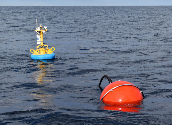
[media-caption path="/wp-content/uploads/2022/11/last_NES_CPM_PMUI-17.jpg" link="#"]This Coastal Profiler Mooring, PMUI-17, was the last Pioneer mooring deployed on the New England Shelf. After providing data through the summer and early fall, it will be recovered in November 2022 and relocated to the Southern Mid-Atlantic Bight in 2024. Credit: Al Plueddemann ©WHOI.[/media-caption]
The Pioneer 19 expedition will be conducted in two legs. The Armstrong will leave port with a nearly empty back deck to allow for carrying back the various parts of the array. During the expedition, three coastal surface moorings, five coastal profiler moorings four coastal gliders, and two global test gliders will be recovered. Additionally, Autonomous Underwater Vehicle (AUV) operations will be conducted in the vicinity of the moored array, as well as CTD (conductivity, temperature, and depth) casts and water sampling at the mooring, AUV, and glider recovery sites. To take full advantage of the time at sea, comparisons of ship and buoy meteorological measurements at the surface mooring sites will be made.
To carry on the collaborative nature of the Pioneer expeditions, during leg 1, the Pioneer Team will be joined by a marine mammal observer from the National Oceanic and Atmospheric Administration and a graduate student from Woods Hole Oceanographic Institution who will be measuring frontal systems, using the shipboard acoustic doppler current profiler and thermosalinograph. Leg 1 will also include a special deployment of a mini-boat surface drifter for an Educational Passages program. This mini-boat was built by students at Waterford School in Connecticut will coincide with the deployment of a similar boat built by students in Ireland.
Leg 2 will include investigators from the New England Shelf Long Term Ecological Research (NES-LTER) Program, who will be conducting underway sampling, and CTD and zooplankton net casts at LTER sites.
An intern from the Marine Advanced Technology Education (MATE) Center will be onboard during both legs.
“While we are all a bit nostalgic about this being the last journey to the Pioneer Array in this location, we are excited about the new science questions that will be answered by the array in its new location.” said Chief Scientist Lund. “We are proud to have been part of collecting nearly a decade’s worth of measurements, which are being used to better understand coastal processes in general with an emphasis on this important New England ocean region.”
Read More
Scientists and Fishers Learning from One Another

At a recent meeting of the Cape Cod Commercial Fishermen’s Alliance, it was evident how much can be learned when scientists and fishers share information. An example was the shifting location of the Gulf Stream. Fred Mattera, President of Commercial Fisheries Research Foundation of Rhode Island, wondered why the temperature of the continental shelf was 72 degrees in December. He contacted Glen Gawarkiewicz, a Woods Hole Oceanographic Institution senior scientist, to share his observation. Gawarkiewicz used data from OOI’s Coastal Pioneer Array to confirm that the Gulf Stream, which carries warm and salty water, had shifted 120 miles north. Gawarkiewicz explained to the audience that he would have never identified this change if it hadn’t been for Mattera’s contact.
This is but one example of how those who use the ocean and those who study it can benefit by sharing information. To read more:
Read More
Chlorophyll Enhancement at the Shelfbreak
Adapted and condensed by OOI from Oliver et al., 2022, doi:/10.1029/2021JC017715.
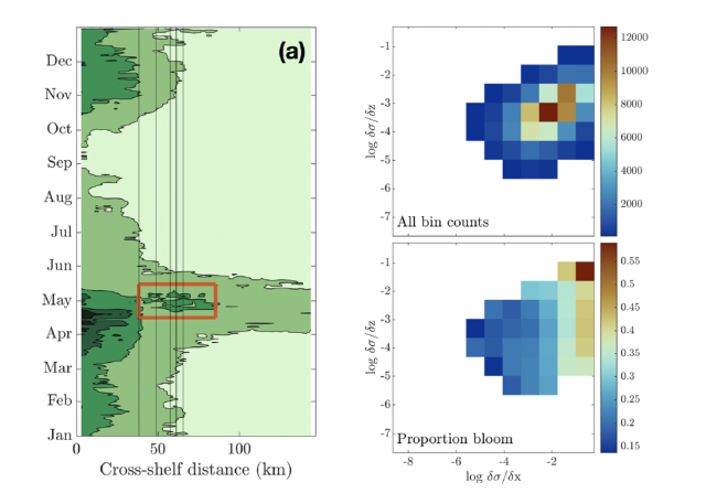
[media-caption path="/wp-content/uploads/2022/08/Screen-Shot-2022-08-18-at-3.10.51-PM.png" link="#"](left) Eighteen-year composite annual cycle of surface chlorophyll concentration from MODIS satellite. Vertical lines indicate the shelfbfreak region (depths 75 to 1,000 m); red box highlights chlorophyll enhancement at the shelfbreak. (right; upper) OOI glider data with more than 100 chlorophyll observations within horizontal and vertical density gradient bins and (lower) proportion of bins with chlorophyll > 2 mg/L, indicating a bloom. From Oliver et al., 2022.[/media-caption]The enhancement of chlorophyll due to phytoplankton blooms is recognized to occur near the frontal boundary of the New England Shelf, but the blooms are ephemeral and not consistently found in satellite remote sensing of ocean color. In a recent study, Oliver et al., (2021) show that enhanced surface chlorophyll concentrations at the shelfbreak are short lived events, and are associated with periods when a surface layer of lighter shelf water moves over denser slope water at the shelfbreak front. Both data and a computational model show that eastward, upwelling-favorable winds are the primary driver of the frontal restratification and localized enhanced surface chlorophyll.
The study used a variety of data sources, including MODIS satellite chlorophyll estimates, shipboard CTD casts from a Shelf-break Productivity Interdisciplinary Research Operation at the Pioneer Array (SPIROPA) cruise and a Pioneer mooring turn cruise, Pioneer glider density and chlorophyll, and atmospheric reanalysis winds after comparison with Pioneer surface mooring winds. A two-dimensional configuration of the Regional Ocean Model System (ROMS) coupled to a nitrogen-phytoplankton-zooplankton-detritus (NPZD) model was used to simulate the wind-driven response.
The eighteen-year time-evolution of the cross-shelf distribution of surface chlorophyll concentration from MODIS showed that shelf-break chlorophyll enhancements were evident in most years, followed an inshore spring bloom in April, and were typically seen during a short period in the spring (mid-April – mid-May; Figure above). For individual years, the shelf-break chlorophyll enhancements were short-lived, typically lasting less than a week. Pioneer Array glider data were used to explore the relationship between enhanced chlorophyll concentrations and both horizontal (assumed to be associated with the shelfbreak front) and vertical density gradients. Near surface (upper 30 m) chlorophyll concentrations were collected in log-transformed density gradient bins and then displayed according to the proportion of bins with chlorophyll > 2 mg/L, indicating a bloom. The “bloom bins” were associated with high horizontal density gradients and a range of vertical density gradients, indicating that frontal restratification is associated with enhanced chlorophyll at the shelfbreak (Figure above).
The study concludes that enhanced surface chlorophyll events at the New England shelfbreak occur consistently in the spring, but are transient, lasting only a few days to a week, and thus not discernible in seasonal climatologies. Periods of enhanced chlorophyll are associated with strong horizontal density gradients and appear to be triggered by the increase in stratification resulting from wind-driven cross-shelf advection of less dense shelf water over denser slope water. This process creates a shallow mixed layer at the front which alleviates light limitation and supports transient surface enhancements of chlorophyll.
Oliver, H., Zhang, W.G., Archibald, K.M., Hirzel, A.J., Smith, W.O. Jr, Sosik, H.M., Stanley, R.H.F and D.J. McGillicuddy Jr (2022). Ephemeral surface chlorophyll enhancement at the New England shelf break driven by Ekman restratification. Journal of Geophysical Research: Oceans, 127, e2021JC017715. https://doi.org/10.1029/2021JC017715.
Read MoreStriped Bass Link OOI Pioneer Array Locations
A recent article in the Martha’s Vineyard Gazette tells a fascinating tale of how fish like striped bass respond to changes in ocean conditions. The striped bass story also provides links between the current OOI Pioneer Array location on the New England Shelf (NES) and the new location in the southern Mid-Atlantic Bight (MAB).
The Northwest Atlantic has been warming due to both atmospheric and oceanographic influences (e.g., Chen et al., 2014; Gawarkiewicz et al., 2019) and the impacts can bee seen in the distribution of marine species like stripers. The stripers are typically found on the New England Shelf in the spring, with bass fishing tournaments a long-held tradition for islands like Martha’s Vineyard, Nantucket, and Cuttyhunk. But conditions are changing, and as the waters warm, the stripers appear to be moving further north. Data from the NES Pioneer Array are helping researchers and fishers understand the changes.
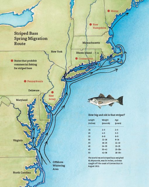
[media-caption path="/wp-content/uploads/2022/05/Striped-Bass-migration-map.jpg" link="#"]Striped bass spring migration route. Credit: Martha’s Vineyard Gazette and Dana Gaines Martha’s Vineyard Magazine.[/media-caption]
Stripers spawn in brackish water and spend their first few years in estuarine waters like those of the Chesapeake Bay. These waters are changing too, with earlier springs modifying spawning behavior. Understanding how environmental conditions impact the life cycle of stripers from estuary to open ocean requires knowledge of the atmosphere, continental shelf waters, and the Gulf Stream. Finally, it is necessary to investigate interactions that exchange properties between estuaries, shelf and slope sea – which will be the focus of the MAB Pioneer Array currently being planned for implementation in 2024.
References
Chen, K., G. G. Gawarkiewicz, S. J. Lentz, and J. M. Bane (2014), Diagnosing the warming of the Northeastern U.S. Coastal Ocean in 2012: A linkage between the atmospheric jet stream variability and ocean response, J. Geophys. Res. Oceans, 119, doi:10.1002/2013JC009393.
Gawarkiewicz G, Chen K, Forsyth J, Bahr F, Mercer AM, Ellertson A, Fratantoni P, Seim H, Haines S and Han L (2019), Characteristics of an Advective Marine Heatwave in the Middle Atlantic Bight in Early 2017. Front. Mar. Sci. 6:712. doi: 10.3389/fmars.2019.00712.
Schneider, P. (2022), Climate Change Clue: Follow the Stripers. Vineyard Gazette, 12 May 2022.
Read MoreSuccessful Last Deployment of Pioneer Array on NE Shelf
The Pioneer 18 Array team and crew of the R/V Neil Armstrong pulled into the dock at Woods Hole, MA, on April 27, a day earlier than expected, having completed all objectives of the expedition. Their mission included the last deployment of the Pioneer Array at its current location on the New England Shelf. The Pioneer Array components now in the water will be recovered in November 2022 and redeployed in the Southern Mid-Atlantic Bight in the Spring of 2024.
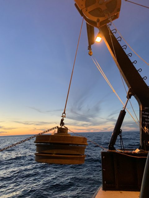
The expedition consisted of two legs. On leg #1, three Coastal Surface Moorings and multiple gliders were recovered and deployed and autonomous vehicle missions were completed. On leg #2, the team deployed five Coastal Profiler Moorings. Three Coastal Surface Moorings and seven Coastal Profiler Moorings were recovered, two of which could not be recovered during an earlier expedition because of weather conditions. The recovered equipment will be taken apart, refurbished, and in some cases, reconfigured for deployment at the new location.
Weather conditions allowed for multiple deployments of a remotely operated vehicle, to help assess the condition and assist in the recovery of mooring components that could not be recovered by standard techniques (using an acoustically-triggered release). The team also conducted additional activities that ranged from water sampling adjacent to the moorings to cross-shelf CTD (conductivity, temperature, and depth) surveys in the vicinity of the moored array, and surveys using shipboard sensors. A variety of ancillary activities, accommodating eight participants from five different institutions, were also facilitated during the cruise.
Al Plueddemann, Principal Investigator of the Coastal and Global Scale Nodes (CGSN) and Chief Scientist of Pioneer 18 said, “The successful completion of this expedition again demonstrates the capabilities and experience of the CGSN team and the R/V Armstrong, and bodes well for successful operation of the Pioneer Array in its new location in the Southern Mid-Atlantic Bight.”
[media-caption path="/wp-content/uploads/2022/05/last_NES_CPM_PMUI-17-copy.jpg" link="#"]The Coastal Profiler Mooring shown here, PMUI-17, will be the last Pioneer mooring deployed on the New England Shelf. After providing data through the summer and early fall, the current array will be recovered in November of 2022 and relocated to the Southern Mid-Atlantic Bight in 2024. Credit: Jess Kozik©WHOI.[/media-caption]
The Pioneer Array was originally commissioned in 2016 as a re-locatable coastal array suitable for moderate to high wind, wave and current regimes on the continental shelf and upper slope. The new location in the Southern Mid-Atlantic Bight was decided upon after a series of workshops in 2021, co-sponsored by the National Science Foundation and the Ocean Observatories Initiative Facility Board, to gain community input on a new location that would best address pressing science questions.
Plueddemann added, “The Pioneer Array has collected a remarkable data set from the New England Shelf, which scientists will continue to use to understand frontal dynamics and related ecosystem impacts in this important and dynamic region.”
[media-caption path="/wp-content/uploads/2022/05/heads_up-copy.jpg" link="#"]When the large Coastal Surface Mooring buoys are recovered everyone pays close attention. The buoy tower spins when the hull is picked out of the water, and the deck team needs to be ready with a snap hook to clip into the circular rails on the tower top and arrest the motion. Credit: Andrew Reed ©WHOI.[/media-caption]
As the Pioneer 18 team headed home, another CGSN expedition is about to hit the water. A team of scientists and engineers is already traveling to Seward, Alaska to mobilize for another OOI expedition. On May 12, they will be aboard the R/V Sikuliaq for a 19-day expedition to the Global Station Papa Array, in the Gulf of Alaska, about 620 nautical miles offshore. This team will deploy five moorings — three for OOI and one each for the National Oceanic and Atmospheric Administration and the University of Washington. Once on site, the team will first deploy the moorings onboard, then recover those that have been in the water for a year. Upon completion, the ship will transit to the demobilization port of Seattle, Washington. Bookmark this site, and follow along on their progress.
Read MoreRide Along with Pioneer 18
 Here’s an opportunity to travel along with the team of sixteen scientists and engineers as they conduct a bi-annual recovery and deployment of ocean observing equipment at the Coastal Pioneer Array. This is the 18th “turn” of the equipment since the observatory was put in place in 2015. The data collected has advanced understanding of the shelf/slope dynamics and impacts on ecosystems. Bookmark this page to follow along on the expedition, which runs through the end of April.
18th Turn of the Pioneer Array in April
Sixteen science party members will be on board the R/V Neil Armstrong during April for each of two legs comprising the eighteenth turn of the Pioneer Array, where moorings are recovered and new ones deployed. This April cruise will be extremely busy, with 32 overall objectives, as well as other ancillary operations. Pioneer 18 is the first cruise since 2020, when COVID-19 protocols were implemented, to support a larger science party to conduct ancillary activities.
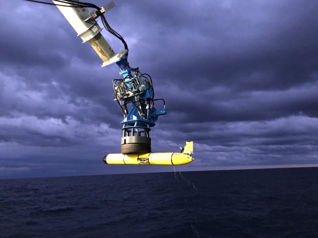
The cruise plan calls for deployment of eight moorings and three gliders and recovery of 10 moorings. Autonomous underwater vehicle (AUV) missions will be conducted in the vicinity of the moored array, providing additional ocean observing measurements. CTD casts and water sampling will be done in conjunction with deployment/recovery operations and ship vs. buoy meteorological comparisons will be made at each Coastal Surface Mooring site.
[media-caption path="/wp-content/uploads/2022/03/DSC0507.jpg" link="#"]During Pioneer 18, ten moorings will be recovered. Once close to the ship, crew members grab the moorings with a hook, and direct them to the stern of the ship to be brought onboard. Credit: Darlene Trew Crist ©WHOI.[/media-caption]
“We are pleased to be approaching full capability for Pioneer 18 after multiple cruises with COVID-related restrictions,” said Al Plueddemann, chief scientist for Pioneer 18 and lead for the Ocean Observatories Initiative Coastal and Global Scale Node of which the Pioneer Array is part. “There is a lot to accomplish over our 21 days at sea, and having the opportunity again to bring collaborating scientists onboard will make full use of the ship and our time at sea.”
On Leg 1, Scientists Mei Sato of Woods Hole Oceanographic Institution (WHOI) will join Pioneer 18 to conduct zooplankton sonar testing, Peter Duley of the National Oceanic and Atmospheric Administration will conduct Marine Mammal Observations, and a student from the University of Rhode Island will oversee a glider deployment. Additionally, unattended underway sampling will be conducted in support of the Northeast U.S. Shelf (NES) Long-Term Ecological Research (LTER) project on Leg 1. On Leg 2, NES-LTER efforts will increase, with four participants (two from WHOI and two from the University of Rhode Island) onboard to conduct activities that include CTD and ring net casts and incubations, as well as continuing unattended underway sampling.
[media-caption path="/wp-content/uploads/2022/03/IMG_6146.jpeg" link="#"]Plans are to deploy three gliders that will collect data in the water column between the Pioneer moorings for the next sixth months. Credit: Darlene Trew Crist ©WHOI.[/media-caption]
Weather conditions and time constraints during the Pioneer 17 cruise precluded complete recovery of the Offshore and Upstream Offshore Profiler Moorings. Additional objectives for Pioneer 18, to be conducted if time and conditions permit, include completing the recovery of these two moorings, as well as several anchor recoveries using a remotely operated vehicle (ROV), glider tests, and surveys in the vicinity of the Pioneer moored array using shipboard systems (CTD, ADCP, EK-80).
“We have a very ambitious agenda for Pioneer-18, but our team is experienced and well-equipped to complete this large list of tasks ,” added Plueddemann. “We just need a good weather window to get the job done.”
Pioneer 18 team members will be sharing their progress during the month of April. Bookmark this page and follow along.
Read More
Initiation of a Marine Heat Wave
Adapted and condensed by OOI from Chen et al., 2022, doi:epdf/10.1029/2021JC017927.
Marine heat waves are sustained, anomalous ocean warming events with significant regional extent. In some cases, these heat waves are driven by heating from the atmosphere. In new work (Chen et al. 2022), it is shown that ocean processes can also be responsible for marine heat waves. In this case, the presence of anomalously high temperatures on the New England shelf was detected by CTD observations made by commercial fishing vessels. The fishing vessel CTD data indicated that the heat wave was a “compound event”, i.e. one with large anomalies in both temperature and salinity. Because atmospheric heating would drive only a temperature anomaly, and because the Gulf Stream derived slope water offshore of the New England shelf is high in both temperature and salinity, it was surmised that this heat wave was driven by ocean advection.
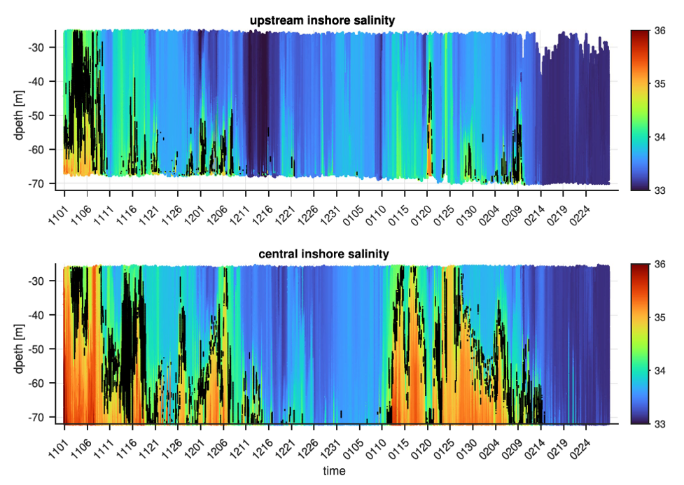
[media-caption path="/wp-content/uploads/2022/02/CGSN1.png" link="#"]Figure 23. Salinity contoured vs. depth and time for the Pioneer Upstream Inshore (PMUI) and Central Inshore (PMCI) profiler moorings from November 2016 to February 2017. The 34.5 isohaline is marked in black to highlight the boundary between the shelf and slope waters.[/media-caption]
The authors used data from Pioneer Array profiler moorings (PMUI and PMCI) to support this ocean advection hypothesis. Salinity records (Figure 23) show high salinity events in Nov/Dec 2016 and Jan 2017. The salinity anomalies are indicative of slope water (S > 34.5), are most intense at the bottom, and are more pronounced further offshore. This is consistent with a bottom intensified intrusion of warm, salty slope water onto the shelf to initiate the heat wave observed by the fishing fleet CTDs in January of 2017.
Further investigation was done to understand the cross-shelf exchange process, which presumably originated at the shelfbreak and penetrated large distances onshore as a bottom intrusion. The principal tool for the additional analysis was a new high-resolution regional model. The model was able to reproduce major features including shelf water properties, the shelf break front, and warm-core rings in the slope sea . Critically, the model showed the presence of cyclonic eddies (opposite in rotation, thinner and smaller than the warm core rings) that were responsible for driving cross-shelf flow and intensifying the front. The authors argue that these processes precondition the outer shelf by bringing warm salty water to the shelf break, i.e. roughly the 100 m isobath.
Another step is necessary to produce the dramatic, bottom intensified intrusion of warm salty water to ~50 m depth, as seen in January 2017. Further examination of the model, including runs with and without wind forcing, indicated that persistent upwelling-favorable winds along with topographic effects were the additional ingredients necessary to cause the dramatic intrusion. Although some onshore penetration results from the standard “two-dimensional” wind-driven upwelling, the authors found that details of the three-dimensional regional topography were critical to extensive slope water penetration in the form of a warm, salty, bottom-intensified tongue.
Identifying the unusually strong intrusion and finding the hints to a slope-sea origin shows the importance of sustained observing, in this case from both the Pioneer Array and the fishing fleet.
Unraveling this remarkable, multi-step process, with pre-conditioning by small-scale cyclonic eddies followed by a topographically-controlled, wind driven response, is a testament to the power of high-resolution models to fill in dynamical gaps in the observing systems. The authors note that “this study provides dynamical explanations of the observed water mass anomalies across the shelf, offers new insights about cross-shelf exchange… and lays the ground work for future studies.”
__________________________________________________________________
Chen, K., Gawarkiewicz, G., & Yang, J. (2022). Mesoscale and submesoscale shelf-ocean exchanges initialize an advective Marine Heatwave. Journal of Geophysical Research: Oceans, 127, doi:epdf/10.1029/2021JC017927.
Read MoreFishers and OOI Scientists Working Together to Advance Science

An article in the Cape Cod Commercial Fishermen’s Alliance newsletter highlighted the work between its members and scientists at Woods Hole Oceanographic Institution (WHOI), using OOI Pioneer Array data. The collaboration resulted in discovery of …“ all these things happening on the New England Shelf that we didn’t anticipate,” said Al Plueddemann, a senior scientist in physical oceanography at WHOI.
An important change in recent years is an increase in the meandering or “wiggliness” of the Gulf Stream. In addition the Gulf Stream has been generating more “Warm Core Rings,” large clockwise eddies.
Read more about how the collaboration is advancing science here.
Tracking Fish with Acoustics
New RAFOS Ocean Acoustic Monitoring (ROAM) tags have recently been designed to allow geolocation of underwater assets, including pelagic fishes, over large areas in the ocean and even deep into the ocean’s twilight zone.
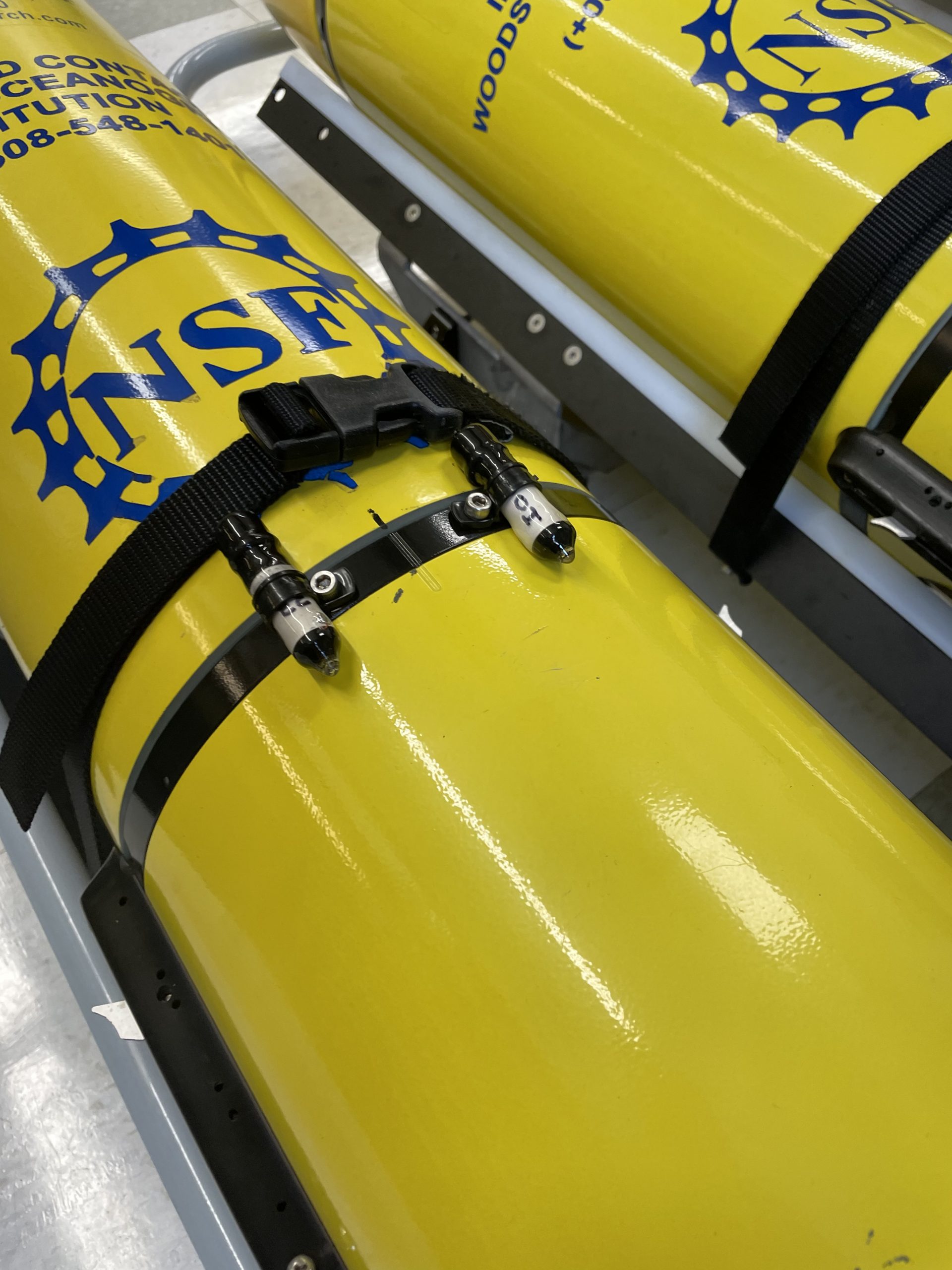
[caption id="attachment_22879" align="alignleft" width="350"]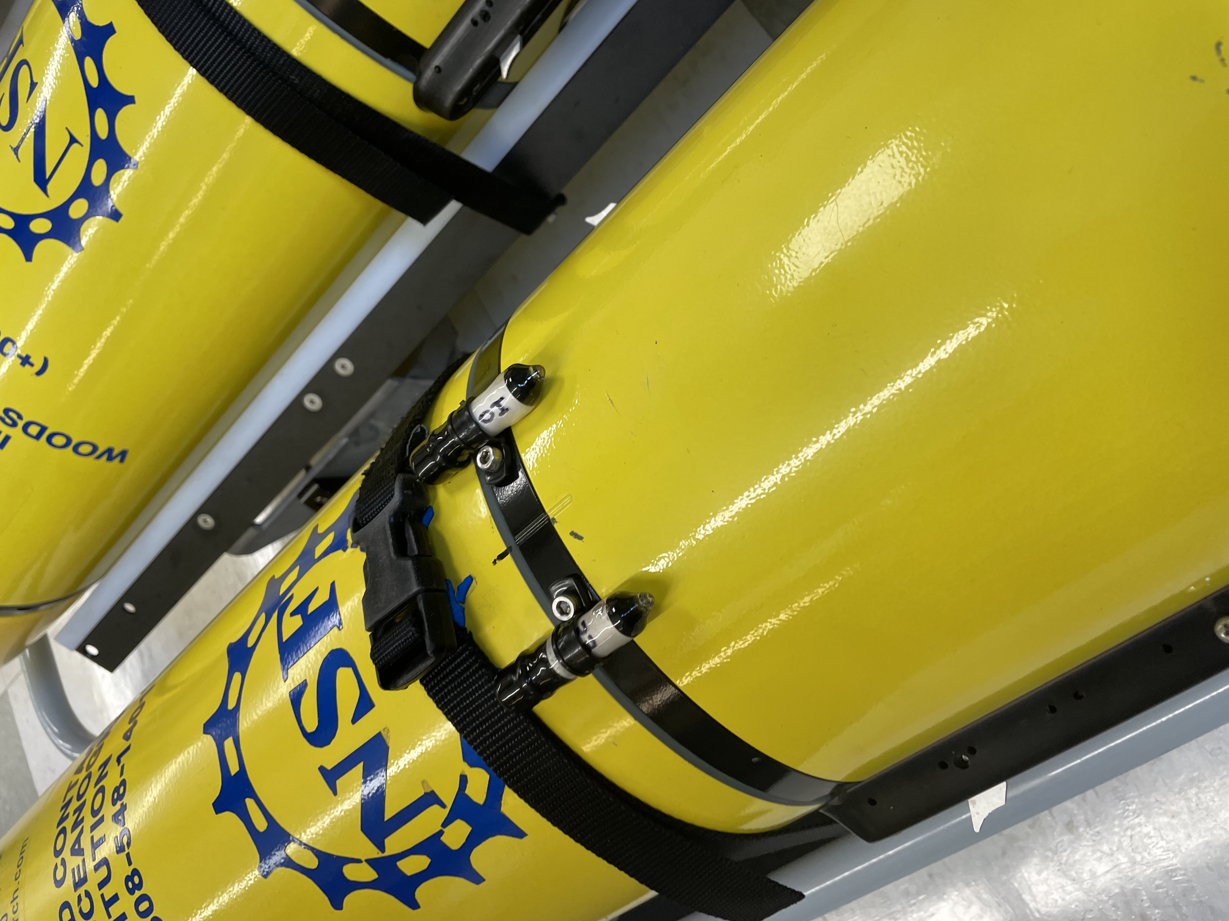 The ROAM tag is small (30 mm x 10 mm) and light enough (8 gm in water) to be attached to an ocean glider with no adverse impacts on performance. Here are two ROAM tags attached to OOI test glider 363 before deployment from the R/V Armstrong during the Pioneer 17 cruise. Credit: ©WHOI, Diana Wickman.[/caption]
An opportunity to test the new ROAM tags arose in conjunction with the October 2021 Pioneer Array mooring service cruise. “We had recently deployed moored sound sources in deep water between Cape Cod and Bermuda,” said Simon Thorrold who, with University of Rhode Island colleagues Melissa Omand and Godi Fischer, is leading the ROAM fish tag development. “One of our goals was to determine whether tagged fish near the continental slope south of New England could be detected using these distant sources.” Thorrold reached out to the OOI team to see if there was potential for a short-term test at the Pioneer Array site, located 75 nautical miles south of Martha’s Vineyard at the shelf-slope interface.
OOI Project Scientist Al Plueddemann and the OOI glider team determined that a glider test planned during the mooring service cruise in late October would be happening at the right place and the right time to be useful for testing the acoustic tags. “This technology is something we would like to consider for OOI, and in particular for the Pioneer Array in its new southern Mid- Atlantic Bight location,” said Plueddemann, “so the potential for a test was of interest to us.”
The glider team determined that the small (30×10 mm), light (8 gm in water) tags would have no measurable impact on glider performance and could be safely accommodated on the test glider. The tags were mounted to the glider by fitting the tags into plastic loop clamps and then securing the loop clamps to existing threaded holes in the glider hull. During the three-day test deployment, the glider made one dive to 50m, one dive to 200m, three dives to 500m, and approximately 76 dives to 200m.
The glider data and acoustic tag data are being evaluated, and will provide information about fish tag performance and the potential for future use within the OOI arrays.
This article was written by Woods Hole Oceanographic Institution colleagues: Senior Scientist Simon Thorrold and Senior Engineering Assistant II Diana Wickman.
Read More