
Posts Tagged ‘Pioneer Array’
Opportunity to Add New Sensors/Equipment to Pioneer MAB Array
The U.S National Science Foundation (NSF) Ocean Observatories Initiative (OOI) is excited to report that the relocation of the Pioneer Array to the Mid-Atlantic Bight (MAB) is now complete and the OOI facility is again considering requests by Principal Investigators to add new sensors and/or equipment to the Pioneer MAB Array. The process for requesting additions to the Array is described here.
The MAB deployment is the culmination of a three-year, multi-tiered process to relocate the Pioneer Array from its former location off the New England Shelf to the MAB. The NSF and the OOI Facilities Board (OOIFB) hosted a series of workshops in 2021 to elicit community input on where a relocated Pioneer Array might best meet science and educational needs. Based on input from these community workshops, the NSF gave its approval to the MAB site and the process was launched. Data from most instruments is available in real-time from the OOI Data Explorer. All non-telemetered data will be available after instruments are recovered on Array maintenance cruises that occur at nominal six-month intervals (April, October).
“Completing installation of the Pioneer Array in the MAB was the culmination of a significant effort by the OOI Team,” said Al Plueddemann, who served as the Chief Scientist for the first deployment of the array in the MAB and is Principal Investigator for OOI’s Coastal and Global Scale Nodes. “The time is right for researchers to propose additional sensors or equipment be added to the array so its full data collection potential can be realized.”
Notes:
- The installation of some sensors, especially acoustic sensors, may be subject to compliance with NSF’s Memorandum of Understanding with the US Navy.
- While the requests must be made for any additions to the Array, OOI would appreciate notification on plans to deploy stand-alone instrumentation within the OOI footprint.
 Pioneer MAB Layout[/caption]
Read More
Pioneer MAB Layout[/caption]
Read More NSF Issues Notice of Draft Supplemental Site-Specific Environmental Assessment for Pioneer Relocation
The NATIONAL SCIENCE FOUNDATION posted the following announcement today, September 29, 2023:
MEMORANDUM FOR: TRIBES, GOVERNMENT AGENCIES, ORGANIZATIONS, INDIVIDUALS, AND INTERESTED PARTIES
FROM: NATIONAL SCIENCE FOUNDATION (NSF)
RE: Notice of Availability of a Draft Supplemental Site-Specific Environmental Assessment for the NSF Ocean Observatory Initiative (OOI) Pioneer Array Modifications and Relocation to the Mid-Atlantic Bight
The National Science Foundation (NSF) gives notice of the availability of the “Draft Supplemental Site-Specific Environmental Assessment for Pioneer Array Modifications and Relocation to the Mid-Atlantic Bight” (Draft SSSEA) for review and public comment.
NSF proposes to fund the relocation, operation, and maintenance of the NSF Ocean Observatory Initiative’s (OOI) Pioneer Array to the Mid-Atlantic Bight (MAB) off North Carolina in the Northwest Atlantic Ocean (Proposed Action). The OOI is a globally distributed, networked, ocean-focused research observatory with arrays of sophisticated instruments that utilize cutting-edge technologies to observe and study ocean processes. The Pioneer MAB Array would represent a Coastal Scale Node component of the OOI. The Pioneer MAB Array is designed to resolve transport processes and ecosystem dynamics in the vicinity of the shelf-break front, a region of high biological productivity and complex oceanographic dynamics that include intense mesoscale variability and episodic event disturbances (i.e., hurricanes). It would collect high-resolution, multidisciplinary, synoptic measurements spanning the shelf break on horizontal scales from a few kilometers to several hundred kilometers. The array is designed and planned to be relocatable approximately (~) every 5 years with new locations proposed by the NSF with input from the scientific community.
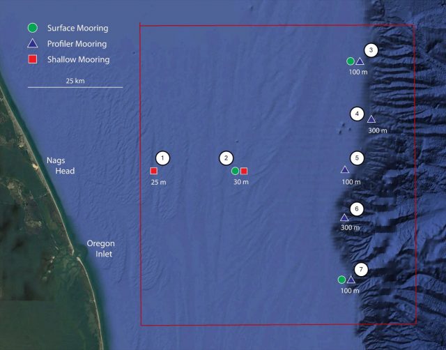
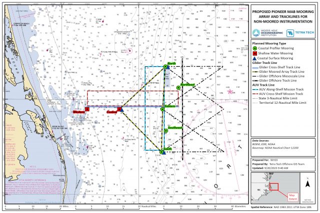
The Proposed Action would (1) relocate the Pioneer New England Shelf (Pioneer NES) Array to the southern MAB (Pioneer MAB Array, Figure 1); 2) modify the mooring designs for the new site water depths; and 3) include additional scientific instrumentation on the moorings. The Proposed Action would occur within the Exclusive Economic Zone (EEZ) of the U.S. but outside of state waters. The Pioneer MAB Array would be a T-shape array located off the coast of Nags Head, North Carolina, starting ~24 kilometers (km) (~13 nautical miles [nm]) offshore, extending ~59 km (~32 nm) east/west and ~49 km (~26 nm) north/south across the continental shelf, centered at the shelf-break front. The Project Area, including the surrounding area of potential effect, would consist of 10 moorings and a 2 km by 2 km (1 nm by 1 nm) square around the center point of each of the mooring locations. In addition, there would be mobile assets, such as autonomous underwater vehicles (AUVs) and gliders that would operate around the moorings. Gliders and AUVs would run underwater missions along tracks in the vicinity of the moored array. Two (2) AUVs and four (4) gliders would be used to provide underwater monitoring abilities along and across the shelf and within the waters of the continental slope. Gliders would be deployed on a 60-90-day rotation schedule and would be operated continuously along pre-determined paths, while the AUVs would be deployed for limited periods of ~4 days every 2 months.
[media-caption path="https://oceanobservatories.org/wp-content/uploads/2023/09/SSSEA-Figure-1-revised38-scaled.jpg" link="#"]Figure 1. Proposed Pioneer MAB Array of Moorings and Surface Projection of Underwater Track lines for Mobile Assets[/media-caption]The Pioneer MAB Array is proposed to be deployed in April 2024. The array and associated AUVs and gliders would be serviced primarily by vessels from the U.S. Academic Research Fleet (ARF) with support from local chartered vessels when needed; a proposed schedule for installation, operations, and maintenance is included in the Draft SSSEA. Installation, operations, and maintenance activities would use standard methods and procedures currently used by the ocean observing community. Like on the Pioneer NES Array, the moorings deployed at Pioneer MAB would include anchors and benthic nodes designed to be fully recoverable, minimizing impact on the seabed.
The Draft SSSEA evaluated the potential impacts of the Proposed Action on the human and natural environment, pursuant to the National Environmental Policy Act (NEPA) and tiers to existing OOI NEPA documentation1. The Draft SSSEA focused on activities and associated potential impacts on marine resources (e.g., geological, marine biological, socioeconomic, etc.) that were not previously assessed by existing OOI NEPA analyses. The conclusions from the Draft SSSEA were used to inform the NSF Division of Ocean Sciences (OCE) of potential environmental impacts of the Proposed Action.
1OOI NEPA documents are available on the NSF website.
Impacts from the placement of proposed mooring anchors or nodes on the seafloor would include temporary disturbance of soft sediments and coverage of relatively small areas of substrate by the anchors and scientific sensors (~37 m2) for the deployment period. Over time, the natural movement of sediments by ocean currents and burrowing organisms would reestablish natural bottom topography. Upon conclusion of operations, the entire system, including anchors and nodes, would be removed from the MAB Project Area. A small amount of Essential Fish Habitat (EFH) may potentially be impacted during installation activities. The short-term and minor increases in turbidity and sedimentation resulting from system installation, operations, maintenance, and removal would not affect the ability of EFH to support healthy fish populations, and affected areas are expected to recover quickly. The vessels and activity associated with installation and maintenance of the moorings may cause marine species, such as Endangered Species Act (ESA)-listed marine mammals, to avoid the immediate vicinity of the proposed Pioneer MAB Array sites, but this impact would be brief and temporary due to the nature of the proposed activities (estimated time to deploy a mooring with one vessel is 12 to 24 hours). Entanglement and vessel strike/collision threats to marine mammals or sea turtles are not anticipated due to the equipment design, slow operational speed (0.5 to 2 knots), and use of NMFS standard oceanographic marine mammal vessel strike avoidance measures, including special measures for North Atlantic Right Whale. The use of gliders and AUVs is not expected to affect marine species, as the proposed gliders and AUVs are self-contained and move slowly within the water column similar to a dolphin or whale. Additional new scientific instrumentation sensors would be mounted on or incorporated into the existing mooring designs; however no adverse effects to marine species are anticipated from the new sensors. Mooring sites were selected to avoid historic and cultural resources (e.g., shipwrecks).
Specific sensitive areas were considered during early planning and siting of the Pioneer MAB Array. The array would not overlap with or be anticipated to impact artificial reefs or fishery nursery areas. Four of the Pioneer MAB Array moorings would be located within the loggerhead sea turtle Constricted Migratory Corridor; however, they are not anticipated to impede sea turtle migration. The Pioneer MAB Array would not overlap with loggerhead sea turtle Coastal Critical Habitat Designation (sargassum habitat). The Pioneer MAB Array’s southernmost mooring would be located within a joint Snapper-grouper/Coral Reefs and Hardbottom/Dolphin and Wahoo Habit Areas of Particular Concern (HAPC) designated by the South Atlantic Fisheries Management Council (SAFMC). The small scale and temporary nature of the single mooring would have little to no impact on the HAPC. A survey conducted of the sites also did not indicate the existence of corals.
Due to the distance from shore, small footprint, localized and temporary nature (~5 years), interactions between the Proposed Action and other ocean users, including fishing operations, in the study area are expected to be limited. Other activities, including fisheries, could occur within the proposed project area; a safe distance, however, would need to be kept from Pioneer MAB Array individual moorings. Any potential space-use conflicts would be minimized through outreach and communication with ocean users. The USCG would be contacted prior to the deployment of moorings as part of the Private Aids To Navigation (PATON) approval process and the Pioneer MAB Array moorings would be easily visible and avoidable. All mooring locations and associated components of the Pioneer Array would be published in NOAA charts, Notice to Mariners and Local Notice to Mariners. Gliders and AUVs would be marked with the name of the owning organization and a contact telephone number that ocean users could call to report any encounters at sea.
The Draft SSSEA also assessed potential cumulative effects of the Proposed Action. Overall, the combination of the proposed activities with other activities occurring in the region is expected to produce only a negligible increase in overall disturbance effects on the marine environment. Given the distance from shore, small footprint, temporary nature, and experience with Pioneer NES, significant impacts from the Proposed Action are not anticipated on the marine environment. While the Proposed Action may affect EFH and ESA-listed species, adverse effects are not likely. NSF will consult with federal regulatory agencies as applicable and appropriate.
Additional information about the proposed Pioneer MAB Array can be found in the Draft SSSEA and tiered OOI NEPA documentation, including details on relocation, operations, and maintenance; scientific instrumentation; potential effects, and diagrams of the array components.
After reviewing and considering all public comments received during the public comment period and regulatory processes, NSF will issue a Final Supplemental Site-Specific Environmental Assessment (Final SSSEA), accompanied by a decision document.
Public Comments:
The Draft SSSEA regarding the proposed action is posted for public comment on the NSF website closing on October 28, 2023. We welcome any comments you may have on the Draft SSSEA. Comments may be submitted via email to: nsfnepaooipioneer@nsf.gov. Comments received will be addressed in the Final SSSEA.
Read MoreNew Controller Latest in OOI Innovations
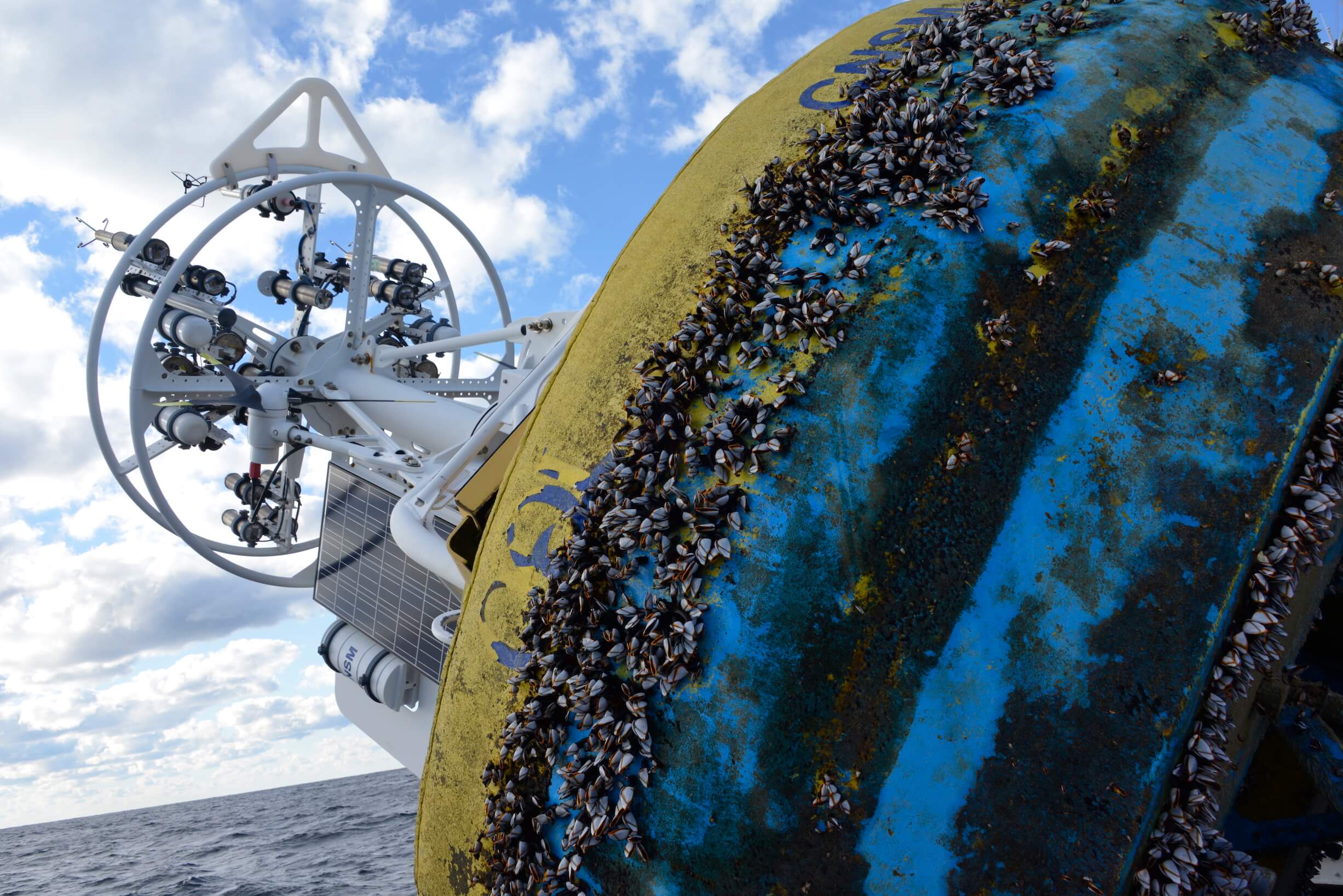
Having equipment in the water around the clock for six months at a time provides many challenges for the land-based OOI engineering team charged with keeping the equipment operational so there is a continual flow of data to shore. Maintaining consistent, reliable power for the ocean observing equipment is at the top of this list of challenges.
OOI’s data-collecting instruments attached to the moorings run on batteries charged by renewable wind and solar energy. OOI is in the process of replacing the current solar panels with new panels that are more efficient at generating energy, even when shaded. To supplement this upgrade, the OOI arrays are also being outfitted with a brand-new solar controller to manage the energy going into the batteries. Like with the new solar panels, OOI engineers looked for a controller that was available commercially for easier repair and replacement.
“What was important to us was finding a way to use these new solar panels in the best, most optimal way,” said Woods Hole Oceanographic Institution (WHOI) engineer Marshall Swartz. “We looked for a company that would help us specify and build a customized algorithm for a controller that would optimize the functionality of the panels by taking into account battery temperatures.”
[media-caption path="/wp-content/uploads/2021/12/DSC0486-2.jpeg" link="#"]Buoys get quite the workout when they are in the water for six months and more. Powered by wind, solar, and batteries, OOI has recently improved the way energy from the solar panels is managed with new controllers. Credit: ©WHOI, Darlene Trew Crist. [/media-caption]
Some larger, older controllers can consume up to 3-5% of the energy coming into the device, but the new controller is smaller and more efficient, helping to optimize the amount of energy harvested.
Temperature conditions play a big role in how effectively the energy is managed. Changing battery temperatures require the controller to adjust its charge settings to maintain battery life and capacity. The controllers used on OOI moorings sense battery temperature and automatically adjust to assure best conditions to assure reliable operation.
“It’s really essential for us to maintain the proper charge levels for existing temperature conditions,” said Swartz. The OOI buoys encounter a wide range of temperatures: from subfreezing temperatures up to 40°C (over 100°F) when a buoy is sitting in the parking lot before it is deployed. When the buoys are deployed, water temperatures can vary widely from -1 to 33°C (~30 to 91°F), depending on seasonal conditions.
The new controller automatically regulates the amount of electricity going into the battery under such varying temperature conditions. If the wind turbines are generating more energy than the battery needs, for example, the controllers direct excess power into an external load that dissipates heat and adds resistance to the spinning of the wind turbines, preventing the turbines from spinning too fast, possibly damaging their bearings.
“As parts of the OOI infrastructure need replacing or to be upgraded, this offers us the opportunity to find more efficient, and often times, off-the-shelf, less-expensive replacements that will help us keep the arrays functioning and data flowing,” Swartz said. “It’s a winning combination for all parts of the operation.”
Read More
Mission Accomplished: Nine Years of Ocean Data in Support of Solid Science
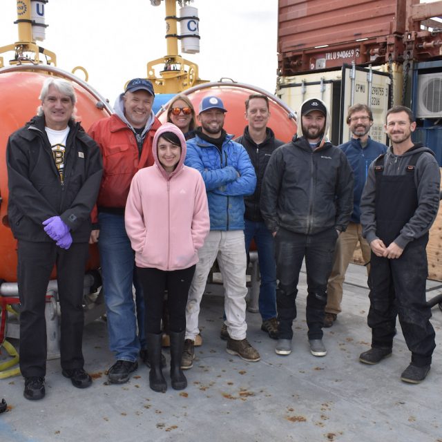
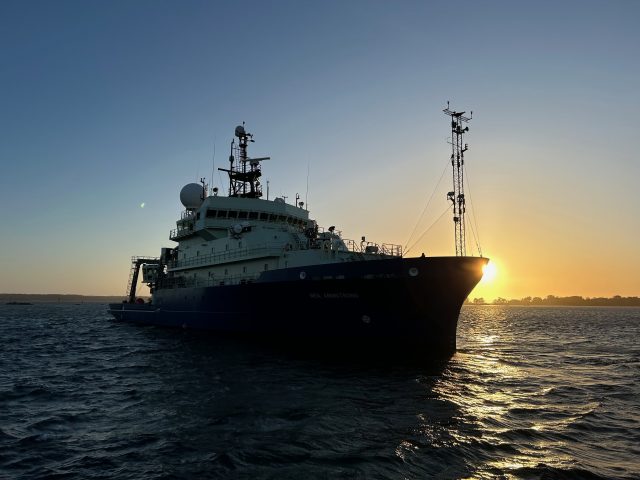
In November 2022 the Woods Hole Oceanographic Institution’s (WHOI) R/V Neil Armstrong made its final voyage off Cape Cod to the location of the Pioneer Array, marking the end of nearly a decade of data collection as part of the National Science Foundation’s (NSF) Ocean Observatories Initiative (OOI). The mission of this cruise, Pioneer 19, was to perform the final recovery of all ten instrumented moorings and four gliders that had been collecting multidisciplinary ocean and atmospheric measurements since Pioneer 1 was first deployed in 2013. Over the course of nine years, the array, weighing in at nearly 60 tons, was recovered and redeployed twice per year for a total of 18 times, while it collected and transmitted measurements from hundreds of instruments back to shore and over the internet without interruption.
[media-caption path="/wp-content/uploads/2022/11/DSC_0901.jpg" link="#"]The Pioneer 19 Science Party marks the occasion of the first deployment of the Central Surface Mooring that launched the Coastal Pioneer Array on November 21, 2013. The team had their photo taken aboard the R/V Neil Armstrong at the exact time (1:16 pm) when the very first mooring was in place. Credit: Rebecca Travis © WHOI.[/media-caption]
The Pioneer Array was conceived as part of the OOI, which represents a paradigm shift in oceanography. Unlike traditional oceangoing research cruises that may last for a few weeks and are often focused on a particular topic by a specific research group, multidisciplinary data from the OOI arrays are provided in near real-time 24 hours a day, 365 days per year to anyone with an internet connection, for an expected duration of 30 years. The OOI originally consisted of seven arrays in the North and South Atlantic, strategically deployed in water depths ranging from 25 to several thousand meters, to collect measurements related to ocean processes that impact life on the planet. Scientists, educators, and laypersons have taken full advantage of these data since the first of OOI’s array went into the water.
Charting a Trail-Blazing Path
To meet the need for reliable operations of uncrewed cabled and uncabled observatory platforms deployed to the world’s oceans for 30 years, the OOI adopted and tailored formal systems engineering processes established for mission critical systems by government organizations such as NASA and the Department of Defense. These processes included the establishment of science objectives for the OOI that were used to develop engineering requirements. The engineering requirements were decomposed to atomic, testable, “level four” requirements used to create preliminary and detailed software, mechanical, and electrical designs for the OOI infrastructure. While OOI leveraged technology from existing state-of-the-art ocean observing systems, some of the new requirements adopted by OOI included year-long deployments of moorings and gliders in some of the harshest locations in the global oceans. Some of the challenges included instrumenting active seafloor volcanic regions via cables that extend for hundreds of miles across the seabed, telemetering measurements from more than 900 instruments on the seabed, buoys, and free-swimming vehicles to shore via satellite for posting to the internet in near real-time, and piloting a glider fleet that is second in size to the US Navy around the clock.
Pioneer 1 departed on 20 November 2013 from the WHOI dock aboard the RV Knorr, a storied academic research vessel responsible for supporting some of the most significant ocean discoveries of the past century. The mission of Pioneer 1 was to deploy one surface mooring and two profiler moorings during seven days of operation on site. With a 14-person science party aboard, the Knorr steamed to the predetermined site for the “Central Surface Mooring” of the Pioneer Array and completed the deployment of the first mooring by 1:16 PM on 21 November 2013. Later Pioneer cruises would fully populate the array by increasing the number of deployed moorings to include three Surface Moorings, each weighing nine tons, and five Profiler Moorings, at six tons each, plus up to six free-swimming gliders.
Since 2013, the Pioneer Array has steadfastly done its job, collecting, and telemetering measurements to shore, which have been used in tens of science studies leading to new understandings about coastal processes and the health of the planet. The journey does not end with the completion of Pioneer 19. The Pioneer Array will be refurbished and adapted to meet new requirements associated with its next deployment site off North Carolina, with its first deployment scheduled for spring 2024. The wealth of data collected off the New England Shelf will remain available online and continue to be used to answer scientific questions about this region for years to come.
Written by Paul K. Matthias, Senior Program Manager for the OOI.
Read More
Students’ Mini-Boat and Drifter Launched from R/V Neil Armstrong
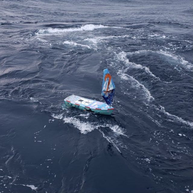
On Sunday November 13, 2022, the Pioneer 19 Team and crew of the R/V Neil Armstrong switched gears from their Pioneer recovery operations to launch a mini-boat and a drifter. Both were constructed by high school students from Waterford, CT, with the help of fourth grade Waterford students, who decorated its sails and hull. The boat is part of the Educational Passages program run by Cassie Stymiest in which the Connecticut high school students participate. The drifter is part of the Student Drifters program developed by the National Oceanic Atmospheric Association (NOAA) and now administered by the Gulf of Maine Lobster Foundation.
The boat, named Lady Lance, contains art inside and messages focused on climate hope and ocean optimism. The students will track the boat’s progress across the Atlantic, as well as the drifter, with the help of James Manning, a retired NOAA employee. Students in Michael O’Connor’s Early College Experience Marine Science Class at Waterford High School built the boat and will follow its progress for the remainder of the school year. The students will follow the progress of both, using GPS telemetry.
[media-caption path="/wp-content/uploads/2022/11/WhatsApp-Image-2022-11-14-at-9.53.24-AM.jpeg" link="#"]The mini-boat was successfully launched from the deck of the R/V Neil Armstrong on Sunday November 13. The boat hopes to make its way across the Atlantic as did its predecessor. Credit: John Lund ©WHOI.[/media-caption]
“We are delighted to be able to support the work of the Waterford students,“ said John Lund, Chief Scientist of the Pioneer Array recovery team aboard the R/V Neil Armstrong. “Their interest, curiosity, and enthusiasm for this project is contagious, and we all will be tracking Lady Lance as she moves through the Atlantic. We also hope that some students are so inspired by this work that they go on to be scientists.”
Lady Lance is the second of such trans-Atlantic launches. The first occurred in 2016 when Lady Lance’s sister ship, Lancer, was launched from the R/V Neil Armstrong. (A good explanation of the winds and currents Lady Lance may encounter is provided at 8:30). The boat’s journey will be influenced by the wind, while the drifter’s journey will be dictated by the currents, allowing for comparisons of conditions in the ocean region.
Lancer ultimately landed in Galway, Ireland, where it was found by a young girl who was also a Sea Scout. People in Connecticut and Galway raised money to have it refurbished and it was re-launched by The Irish Marine Institute. From Ireland, the boat made its way to the United Kingdom where it landed in Plymouth, England. The boat was refurbished by the Ocean Conservation Trust at the National Aquarium in Plymouth and served as a focus for their STEMFEST, which hosted more than 50 school groups from around the UK. STEMFEST students created projects that will be sent in an upcoming Lancer launch at the end of November. An affiliated project, Project Ocean Climate Nexus (Project OCN), is hosting a conference at the National Aquarium in March. Participants will see student research based on the data produced by the mini boats and drifters, students from the US and UK presenting projects.
The Spanish Institute of Oceanography will launch Lancer at the end of November, nearly in sync with Lady Lancer’s launch from the opposite side of the Atlantic.
[media-caption path="/wp-content/uploads/2022/11/WhatsApp-Image-2022-11-14-at-9.53.27-AM-2.jpeg" link="#"]A drifter was also successfully launched to spread messages of hope about the ocean across the Atlantic. Credit: John Lund ©WHOI.[/media-caption]
“While the students have put hard work into the development of these instruments, the real hard work begins upon launch. They will be following the boat and drifter, analyzing data from the boats and adding those data points to other data available from sources like the Pioneer Array and other data sets that are publicly available, to ask questions about the physical and chemical functions of the ocean and atmosphere,” said Michael O’Connor, Waterford High School Marine Science teacher. “The project serves as a launching point to do some independent analysis and to connect with and contribute to the world through science, art, and technology.”
The students have provided digital ways for everyone to follow along with these trans-Atlantic crossings:
- Both Lancer and Lady Lance are trackable from https://educationalpassages.org/events/atsea/
- Lady Lance and her drifter can be tracked here: https://studentdrifters.org/tracks/drift_whs_2022_1.html
- Lady Lance’s drifter data can be accessed here: https://studentdrifters.org/tracks/drift_whs_2022_1.dat or .csv
Read More
Recovery of Pioneer Array in November
On November 9, 2022, a team of 18 scientists and engineers will leave the dock at Woods Hole, MA aboard the R/V Neil Armstrong on an historic expedition. It will be the nineteenth, and last, expedition to the Coastal Pioneer Array on the New England Shelf (NES). This is because the team will be recovering, but not redeploying the NES Pioneer array as in prior years. Designed to be relocatable, the array will be moved to a new location in theSouthern Mid-Atlantic Bight in early 2024. The ocean observing data collected since 2016 at the NES site, about 75 nautical miles south of Martha’s Vineyard, has provided valuable insights into changing ocean conditions at the Atlantic continental shelf and upper slope. The New England Shelf Pioneer data will remain available to the community for continued analysis.
“The Coastal Pioneer Array has been a true workhorse, providing valuable, consistent data from this important intersection in the ocean, where ocean currents meet in weather-like “fronts,” and where heat, salt, nutrients, and other properties are exchanged between the coast and the deep ocean “said Chief Scientist John Lund, who has been on 18 of Pioneer’s 19 expeditions.
“The impacts of the Coastal Pioneer Array have been many,” added Al Plueddemann, Principal Investigator of OOI Coastal and Global Scale Nodes. “To my knowledge, OOI Pioneer is the first sustained, interdisciplinary shelfbreak observatory. Pioneer data have allowed researchers to identify new shelf-slope dynamics and exchange mechanisms and have given us a first glimpse of what appears to be a changing coastal regime. It is very gratifying to see these outcomes, and to recognize the promise of continued findings using the data for years to come.”
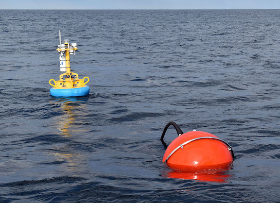
[media-caption path="/wp-content/uploads/2022/11/last_NES_CPM_PMUI-17.jpg" link="#"]This Coastal Profiler Mooring, PMUI-17, was the last Pioneer mooring deployed on the New England Shelf. After providing data through the summer and early fall, it will be recovered in November 2022 and relocated to the Southern Mid-Atlantic Bight in 2024. Credit: Al Plueddemann ©WHOI.[/media-caption]
The Pioneer 19 expedition will be conducted in two legs. The Armstrong will leave port with a nearly empty back deck to allow for carrying back the various parts of the array. During the expedition, three coastal surface moorings, five coastal profiler moorings four coastal gliders, and two global test gliders will be recovered. Additionally, Autonomous Underwater Vehicle (AUV) operations will be conducted in the vicinity of the moored array, as well as CTD (conductivity, temperature, and depth) casts and water sampling at the mooring, AUV, and glider recovery sites. To take full advantage of the time at sea, comparisons of ship and buoy meteorological measurements at the surface mooring sites will be made.
To carry on the collaborative nature of the Pioneer expeditions, during leg 1, the Pioneer Team will be joined by a marine mammal observer from the National Oceanic and Atmospheric Administration and a graduate student from Woods Hole Oceanographic Institution who will be measuring frontal systems, using the shipboard acoustic doppler current profiler and thermosalinograph. Leg 1 will also include a special deployment of a mini-boat surface drifter for an Educational Passages program. This mini-boat was built by students at Waterford School in Connecticut will coincide with the deployment of a similar boat built by students in Ireland.
Leg 2 will include investigators from the New England Shelf Long Term Ecological Research (NES-LTER) Program, who will be conducting underway sampling, and CTD and zooplankton net casts at LTER sites.
An intern from the Marine Advanced Technology Education (MATE) Center will be onboard during both legs.
“While we are all a bit nostalgic about this being the last journey to the Pioneer Array in this location, we are excited about the new science questions that will be answered by the array in its new location.” said Chief Scientist Lund. “We are proud to have been part of collecting nearly a decade’s worth of measurements, which are being used to better understand coastal processes in general with an emphasis on this important New England ocean region.”
Read More
Chlorophyll Enhancement at the Shelfbreak
Adapted and condensed by OOI from Oliver et al., 2022, doi:/10.1029/2021JC017715.
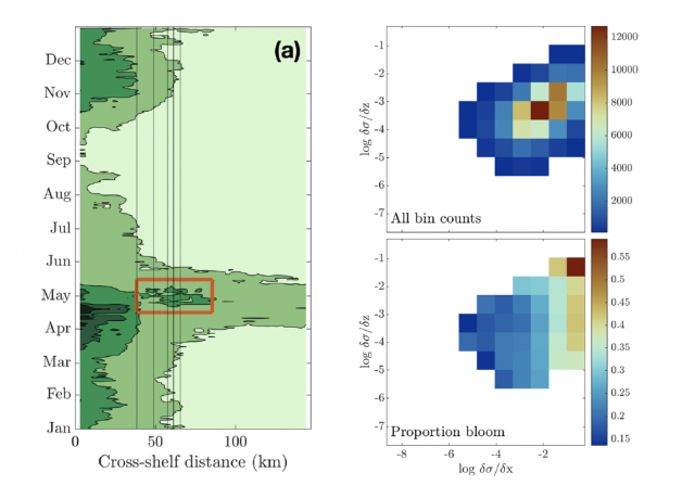
[media-caption path="/wp-content/uploads/2022/08/Screen-Shot-2022-08-18-at-3.10.51-PM.png" link="#"](left) Eighteen-year composite annual cycle of surface chlorophyll concentration from MODIS satellite. Vertical lines indicate the shelfbfreak region (depths 75 to 1,000 m); red box highlights chlorophyll enhancement at the shelfbreak. (right; upper) OOI glider data with more than 100 chlorophyll observations within horizontal and vertical density gradient bins and (lower) proportion of bins with chlorophyll > 2 mg/L, indicating a bloom. From Oliver et al., 2022.[/media-caption]The enhancement of chlorophyll due to phytoplankton blooms is recognized to occur near the frontal boundary of the New England Shelf, but the blooms are ephemeral and not consistently found in satellite remote sensing of ocean color. In a recent study, Oliver et al., (2021) show that enhanced surface chlorophyll concentrations at the shelfbreak are short lived events, and are associated with periods when a surface layer of lighter shelf water moves over denser slope water at the shelfbreak front. Both data and a computational model show that eastward, upwelling-favorable winds are the primary driver of the frontal restratification and localized enhanced surface chlorophyll.
The study used a variety of data sources, including MODIS satellite chlorophyll estimates, shipboard CTD casts from a Shelf-break Productivity Interdisciplinary Research Operation at the Pioneer Array (SPIROPA) cruise and a Pioneer mooring turn cruise, Pioneer glider density and chlorophyll, and atmospheric reanalysis winds after comparison with Pioneer surface mooring winds. A two-dimensional configuration of the Regional Ocean Model System (ROMS) coupled to a nitrogen-phytoplankton-zooplankton-detritus (NPZD) model was used to simulate the wind-driven response.
The eighteen-year time-evolution of the cross-shelf distribution of surface chlorophyll concentration from MODIS showed that shelf-break chlorophyll enhancements were evident in most years, followed an inshore spring bloom in April, and were typically seen during a short period in the spring (mid-April – mid-May; Figure above). For individual years, the shelf-break chlorophyll enhancements were short-lived, typically lasting less than a week. Pioneer Array glider data were used to explore the relationship between enhanced chlorophyll concentrations and both horizontal (assumed to be associated with the shelfbreak front) and vertical density gradients. Near surface (upper 30 m) chlorophyll concentrations were collected in log-transformed density gradient bins and then displayed according to the proportion of bins with chlorophyll > 2 mg/L, indicating a bloom. The “bloom bins” were associated with high horizontal density gradients and a range of vertical density gradients, indicating that frontal restratification is associated with enhanced chlorophyll at the shelfbreak (Figure above).
The study concludes that enhanced surface chlorophyll events at the New England shelfbreak occur consistently in the spring, but are transient, lasting only a few days to a week, and thus not discernible in seasonal climatologies. Periods of enhanced chlorophyll are associated with strong horizontal density gradients and appear to be triggered by the increase in stratification resulting from wind-driven cross-shelf advection of less dense shelf water over denser slope water. This process creates a shallow mixed layer at the front which alleviates light limitation and supports transient surface enhancements of chlorophyll.
Oliver, H., Zhang, W.G., Archibald, K.M., Hirzel, A.J., Smith, W.O. Jr, Sosik, H.M., Stanley, R.H.F and D.J. McGillicuddy Jr (2022). Ephemeral surface chlorophyll enhancement at the New England shelf break driven by Ekman restratification. Journal of Geophysical Research: Oceans, 127, e2021JC017715. https://doi.org/10.1029/2021JC017715.
Read MoreStriped Bass Link OOI Pioneer Array Locations
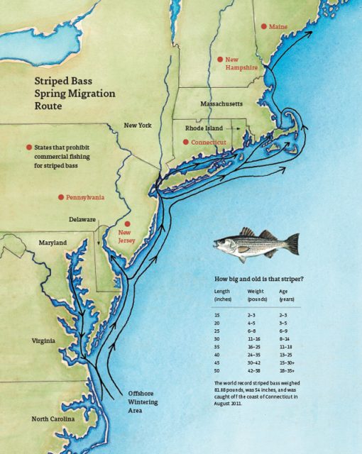
A recent article in the Martha’s Vineyard Gazette tells a fascinating tale of how fish like striped bass respond to changes in ocean conditions. The striped bass story also provides links between the current OOI Pioneer Array location on the New England Shelf (NES) and the new location in the southern Mid-Atlantic Bight (MAB).
The Northwest Atlantic has been warming due to both atmospheric and oceanographic influences (e.g., Chen et al., 2014; Gawarkiewicz et al., 2019) and the impacts can bee seen in the distribution of marine species like stripers. The stripers are typically found on the New England Shelf in the spring, with bass fishing tournaments a long-held tradition for islands like Martha’s Vineyard, Nantucket, and Cuttyhunk. But conditions are changing, and as the waters warm, the stripers appear to be moving further north. Data from the NES Pioneer Array are helping researchers and fishers understand the changes.
[media-caption path="/wp-content/uploads/2022/05/Striped-Bass-migration-map.jpg" link="#"]Striped bass spring migration route. Credit: Martha’s Vineyard Gazette and Dana Gaines Martha’s Vineyard Magazine.[/media-caption]
Stripers spawn in brackish water and spend their first few years in estuarine waters like those of the Chesapeake Bay. These waters are changing too, with earlier springs modifying spawning behavior. Understanding how environmental conditions impact the life cycle of stripers from estuary to open ocean requires knowledge of the atmosphere, continental shelf waters, and the Gulf Stream. Finally, it is necessary to investigate interactions that exchange properties between estuaries, shelf and slope sea – which will be the focus of the MAB Pioneer Array currently being planned for implementation in 2024.
References
Chen, K., G. G. Gawarkiewicz, S. J. Lentz, and J. M. Bane (2014), Diagnosing the warming of the Northeastern U.S. Coastal Ocean in 2012: A linkage between the atmospheric jet stream variability and ocean response, J. Geophys. Res. Oceans, 119, doi:10.1002/2013JC009393.
Gawarkiewicz G, Chen K, Forsyth J, Bahr F, Mercer AM, Ellertson A, Fratantoni P, Seim H, Haines S and Han L (2019), Characteristics of an Advective Marine Heatwave in the Middle Atlantic Bight in Early 2017. Front. Mar. Sci. 6:712. doi: 10.3389/fmars.2019.00712.
Schneider, P. (2022), Climate Change Clue: Follow the Stripers. Vineyard Gazette, 12 May 2022.
Read MoreSuccessful Last Deployment of Pioneer Array on NE Shelf
The Pioneer 18 Array team and crew of the R/V Neil Armstrong pulled into the dock at Woods Hole, MA, on April 27, a day earlier than expected, having completed all objectives of the expedition. Their mission included the last deployment of the Pioneer Array at its current location on the New England Shelf. The Pioneer Array components now in the water will be recovered in November 2022 and redeployed in the Southern Mid-Atlantic Bight in the Spring of 2024.
The expedition consisted of two legs. On leg #1, three Coastal Surface Moorings and multiple gliders were recovered and deployed and autonomous vehicle missions were completed. On leg #2, the team deployed five Coastal Profiler Moorings. Three Coastal Surface Moorings and seven Coastal Profiler Moorings were recovered, two of which could not be recovered during an earlier expedition because of weather conditions. The recovered equipment will be taken apart, refurbished, and in some cases, reconfigured for deployment at the new location.
Weather conditions allowed for multiple deployments of a remotely operated vehicle, to help assess the condition and assist in the recovery of mooring components that could not be recovered by standard techniques (using an acoustically-triggered release). The team also conducted additional activities that ranged from water sampling adjacent to the moorings to cross-shelf CTD (conductivity, temperature, and depth) surveys in the vicinity of the moored array, and surveys using shipboard sensors. A variety of ancillary activities, accommodating eight participants from five different institutions, were also facilitated during the cruise.
Al Plueddemann, Principal Investigator of the Coastal and Global Scale Nodes (CGSN) and Chief Scientist of Pioneer 18 said, “The successful completion of this expedition again demonstrates the capabilities and experience of the CGSN team and the R/V Armstrong, and bodes well for successful operation of the Pioneer Array in its new location in the Southern Mid-Atlantic Bight.”
[media-caption path="/wp-content/uploads/2022/05/last_NES_CPM_PMUI-17-copy.jpg" link="#"]The Coastal Profiler Mooring shown here, PMUI-17, will be the last Pioneer mooring deployed on the New England Shelf. After providing data through the summer and early fall, the current array will be recovered in November of 2022 and relocated to the Southern Mid-Atlantic Bight in 2024. Credit: Jess Kozik©WHOI.[/media-caption]
The Pioneer Array was originally commissioned in 2016 as a re-locatable coastal array suitable for moderate to high wind, wave and current regimes on the continental shelf and upper slope. The new location in the Southern Mid-Atlantic Bight was decided upon after a series of workshops in 2021, co-sponsored by the National Science Foundation and the Ocean Observatories Initiative Facility Board, to gain community input on a new location that would best address pressing science questions.
Plueddemann added, “The Pioneer Array has collected a remarkable data set from the New England Shelf, which scientists will continue to use to understand frontal dynamics and related ecosystem impacts in this important and dynamic region.”
[media-caption path="/wp-content/uploads/2022/05/heads_up-copy.jpg" link="#"]When the large Coastal Surface Mooring buoys are recovered everyone pays close attention. The buoy tower spins when the hull is picked out of the water, and the deck team needs to be ready with a snap hook to clip into the circular rails on the tower top and arrest the motion. Credit: Andrew Reed ©WHOI.[/media-caption]
As the Pioneer 18 team headed home, another CGSN expedition is about to hit the water. A team of scientists and engineers is already traveling to Seward, Alaska to mobilize for another OOI expedition. On May 12, they will be aboard the R/V Sikuliaq for a 19-day expedition to the Global Station Papa Array, in the Gulf of Alaska, about 620 nautical miles offshore. This team will deploy five moorings — three for OOI and one each for the National Oceanic and Atmospheric Administration and the University of Washington. Once on site, the team will first deploy the moorings onboard, then recover those that have been in the water for a year. Upon completion, the ship will transit to the demobilization port of Seattle, Washington. Bookmark this site, and follow along on their progress.
Read MoreRide Along with Pioneer 18
 Here’s an opportunity to travel along with the team of sixteen scientists and engineers as they conduct a bi-annual recovery and deployment of ocean observing equipment at the Coastal Pioneer Array. This is the 18th “turn” of the equipment since the observatory was put in place in 2015. The data collected has advanced understanding of the shelf/slope dynamics and impacts on ecosystems. Bookmark this page to follow along on the expedition, which runs through the end of April.