
Posts Tagged ‘Pioneer Array’
Initiation of a Marine Heat Wave
Adapted and condensed by OOI from Chen et al., 2022, doi:epdf/10.1029/2021JC017927.
Marine heat waves are sustained, anomalous ocean warming events with significant regional extent. In some cases, these heat waves are driven by heating from the atmosphere. In new work (Chen et al. 2022), it is shown that ocean processes can also be responsible for marine heat waves. In this case, the presence of anomalously high temperatures on the New England shelf was detected by CTD observations made by commercial fishing vessels. The fishing vessel CTD data indicated that the heat wave was a “compound event”, i.e. one with large anomalies in both temperature and salinity. Because atmospheric heating would drive only a temperature anomaly, and because the Gulf Stream derived slope water offshore of the New England shelf is high in both temperature and salinity, it was surmised that this heat wave was driven by ocean advection.
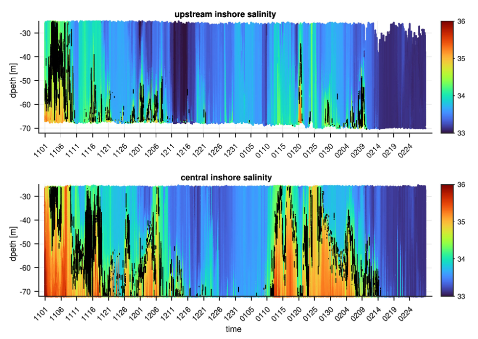
[media-caption path="/wp-content/uploads/2022/02/CGSN1.png" link="#"]Figure 23. Salinity contoured vs. depth and time for the Pioneer Upstream Inshore (PMUI) and Central Inshore (PMCI) profiler moorings from November 2016 to February 2017. The 34.5 isohaline is marked in black to highlight the boundary between the shelf and slope waters.[/media-caption]
The authors used data from Pioneer Array profiler moorings (PMUI and PMCI) to support this ocean advection hypothesis. Salinity records (Figure 23) show high salinity events in Nov/Dec 2016 and Jan 2017. The salinity anomalies are indicative of slope water (S > 34.5), are most intense at the bottom, and are more pronounced further offshore. This is consistent with a bottom intensified intrusion of warm, salty slope water onto the shelf to initiate the heat wave observed by the fishing fleet CTDs in January of 2017.
Further investigation was done to understand the cross-shelf exchange process, which presumably originated at the shelfbreak and penetrated large distances onshore as a bottom intrusion. The principal tool for the additional analysis was a new high-resolution regional model. The model was able to reproduce major features including shelf water properties, the shelf break front, and warm-core rings in the slope sea . Critically, the model showed the presence of cyclonic eddies (opposite in rotation, thinner and smaller than the warm core rings) that were responsible for driving cross-shelf flow and intensifying the front. The authors argue that these processes precondition the outer shelf by bringing warm salty water to the shelf break, i.e. roughly the 100 m isobath.
Another step is necessary to produce the dramatic, bottom intensified intrusion of warm salty water to ~50 m depth, as seen in January 2017. Further examination of the model, including runs with and without wind forcing, indicated that persistent upwelling-favorable winds along with topographic effects were the additional ingredients necessary to cause the dramatic intrusion. Although some onshore penetration results from the standard “two-dimensional” wind-driven upwelling, the authors found that details of the three-dimensional regional topography were critical to extensive slope water penetration in the form of a warm, salty, bottom-intensified tongue.
Identifying the unusually strong intrusion and finding the hints to a slope-sea origin shows the importance of sustained observing, in this case from both the Pioneer Array and the fishing fleet.
Unraveling this remarkable, multi-step process, with pre-conditioning by small-scale cyclonic eddies followed by a topographically-controlled, wind driven response, is a testament to the power of high-resolution models to fill in dynamical gaps in the observing systems. The authors note that “this study provides dynamical explanations of the observed water mass anomalies across the shelf, offers new insights about cross-shelf exchange… and lays the ground work for future studies.”
__________________________________________________________________
Chen, K., Gawarkiewicz, G., & Yang, J. (2022). Mesoscale and submesoscale shelf-ocean exchanges initialize an advective Marine Heatwave. Journal of Geophysical Research: Oceans, 127, doi:epdf/10.1029/2021JC017927.
Read MoreFishers and OOI Scientists Working Together to Advance Science

An article in the Cape Cod Commercial Fishermen’s Alliance newsletter highlighted the work between its members and scientists at Woods Hole Oceanographic Institution (WHOI), using OOI Pioneer Array data. The collaboration resulted in discovery of …“ all these things happening on the New England Shelf that we didn’t anticipate,” said Al Plueddemann, a senior scientist in physical oceanography at WHOI.
An important change in recent years is an increase in the meandering or “wiggliness” of the Gulf Stream. In addition the Gulf Stream has been generating more “Warm Core Rings,” large clockwise eddies.
Read more about how the collaboration is advancing science here.
OOI’s Contributions to Understanding the Changing Ocean Cited in Boston Globe

Woods Hole Oceanographic Institution Research Scientist Glen Gawarkiewicz cites how he uses OOI data to figure out what is happening in the changing ocean in an article on that appeared on the front page of the Boston Globe on December 28, 2021.
In a record-breaking year of weather, signs of a changed world.
[caption id="attachment_22801" align="alignnone" width="1610"] A resident walked through floodwaters left by Hurricane Ida in La Place Louisiana on August 30, 2921. Credit: Luke Sharrett/Bloomberg via the Boston Globe.[/caption]
Read More New Controller Latest in OOI Innovations
Having equipment in the water around the clock for six months at a time provides many challenges for the land-based OOI engineering team charged with keeping the equipment operational so there is a continual flow of data to shore. Maintaining consistent, reliable power for the ocean observing equipment is at the top of this list of challenges.
OOI’s data-collecting instruments attached to the moorings run on batteries charged by renewable wind and solar energy. OOI is in the process of replacing the current solar panels with new panels that are more efficient at generating energy, even when shaded. To supplement this upgrade, the OOI arrays are also being outfitted with a brand-new solar controller to manage the energy going into the batteries. Like with the new solar panels, OOI engineers looked for a controller that was available commercially for easier repair and replacement.
“What was important to us was finding a way to use these new solar panels in the best, most optimal way,” said Woods Hole Oceanographic Institution (WHOI) engineer Marshall Swartz. “We looked for a company that would help us specify and build a customized algorithm for a controller that would optimize the functionality of the panels by taking into account battery temperatures.”
[media-caption path="/wp-content/uploads/2021/12/DSC0486-2.jpeg" link="#"]Buoys get quite the workout when they are in the water for six months and more. Powered by wind, solar, and batteries, OOI has recently improved the way energy from the solar panels is managed with new controllers. Credit: ©WHOI, Darlene Trew Crist. [/media-caption]
Some larger, older controllers can consume up to 3-5% of the energy coming into the device, but the new controller is smaller and more efficient, helping to optimize the amount of energy harvested.
Temperature conditions play a big role in how effectively the energy is managed. Changing battery temperatures require the controller to adjust its charge settings to maintain battery life and capacity. The controllers used on OOI moorings sense battery temperature and automatically adjust to assure best conditions to assure reliable operation.
“It’s really essential for us to maintain the proper charge levels for existing temperature conditions,” said Swartz. The OOI buoys encounter a wide range of temperatures: from subfreezing temperatures up to 40°C (over 100°F) when a buoy is sitting in the parking lot before it is deployed. When the buoys are deployed, water temperatures can vary widely from -1 to 33°C (~30 to 91°F), depending on seasonal conditions.
The new controller automatically regulates the amount of electricity going into the battery under such varying temperature conditions. If the wind turbines are generating more energy than the battery needs, for example, the controllers direct excess power into an external load that dissipates heat and adds resistance to the spinning of the wind turbines, preventing the turbines from spinning too fast, possibly damaging their bearings.
“As parts of the OOI infrastructure need replacing or to be upgraded, this offers us the opportunity to find more efficient, and often times, off-the-shelf, less-expensive replacements that will help us keep the arrays functioning and data flowing,” Swartz said. “It’s a winning combination for all parts of the operation.”
Read More
Marine Mammal Operations Aboard R/V Neil Armstrong During Pioneer 17
The Northeast Fisheries Science Center (NEFSC) had the opportunity to participate on leg two of the Pioneer Array research cruise aboard the R/V Neil Armstrong. The dates for the second leg this year were November 7 – 15 2021. This time frame was critical for us because our main asset for assessing right whale distribution, the NOAA (National Oceanic and Atmospheric Administration)Twin Otter aircraft was scheduled to depart for the Gulf of St. Lawrence Canada, and would not be available. Since 2010 the distribution of the North Atlantic Right whale has changed significantly, and it has become increasingly important to survey more broadly within the range to determine if there are aggregations of right whales in unprotected areas.
Participating scientists from the NEFSC for this cruise were Chris Tremblay and myself, Pete Duley. Chris was brought on for his expertise in acoustics, specifically with the deployment and monitoring of sonobuoys for the detection of North Atlantic Right whales and other large baleen whales. This additional element to our research plan was added to detect right whales in weather when visual observations were not ideal, and to access call types associated with different behaviors from observations with right whales in good visual conditions. Deployment of sonobuoys were conducted with very low or no impact to the mission of the work on the Pioneer array. November 12 was the only day of the entire cruise in which we were unable to conduct visual observations due to the weather. The Northeast U.S Shelf Long Term Ecological Research (NES-LTER) group was conducting a CTD survey across the shelf break and we used this opportunity to make four sonobuoy drops in association with their survey. We are still analyzing the acoustic recordings form the cruise, but at this point feel that they were a valuable addition to the research.
Sonobuoys are launched by hand from the back deck, once permission has been granted by the bridge. The instruments are not meant to be retrieved and can record for up to eight hours. The instruments send information from their hydrophones by VHF transmission (line of sight) to an antenna mounted on one of the upper decks (01), and scuttle themselves after eight hours of recording.
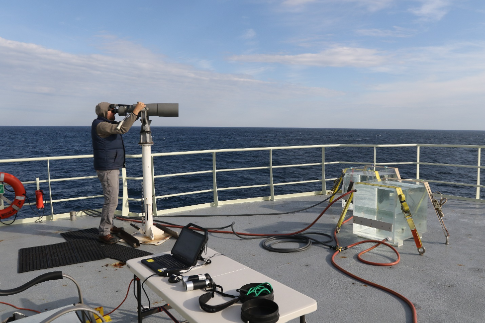
[media-caption path="/wp-content/uploads/2021/11/Bigeyes.png" link="#"]Marine Mammal Observer Chris Tremblay uses Bigeye binoculars to search for right whales during mooring operations by the Pioneer 17 team. Credit: Peter Duley. [/media-caption]
Marine mammal visual operations aboard the Neil Armstrong were conducted from the 01 Deck. Our Bigeye stand would not fit the predrilled holes in the 01 deck and this required Kyle Covert, the ship’s welder, to manufacture some iron fasteners to secure the stand and Bigeye binoculars. This issue was fixed during the staging prior to our departure and worked quite well. The marine mammal observation deck (deck 02) was unavailable to us this year because of Bigeye stand mounting issues. There are plates welded into the deck for the stands, but no predrilled bolt pattern in the deck. The marine mammal deck also has a desk with access to the ship’s SCS (Sea Control Ship) feed, and offers a better vantage point because it is higher. However, even while working in higher sea states we were unaffected by spray from the bow on the 01 deck, and this worked out quite well for this cruise. We brought with us a small desk, some deck chairs, and ratchet straps for securing everything.
The crane on the 01 deck is on the starboard side and caused a slight visual obstruction in panning from 090 to 270 degrees. The location of the Bigeyes aft on the port side, however, provided good visibility nearly to 180 degrees on the port side, which proved useful when stationary during the Pioneer Array mooring deployments and recoveries. We recorded whales aft of the ship during several of these stationary observation periods. Visual observations while underway were conducted from 07:30 to 16:45 and observers rotated from the Bigeyes to the recorder position on the half hour. At the locations where the ship was stationary working on mooring operations for extended periods of time, Chris and I did a scan of the area every 15 minutes. We are still working on analyses of the visual data, and although we did not observe any right whales during the Pioneer 17 cruise we feel that the ship is a great asset for our work and would love for the collaborative effort to continue. Thank you so much for the opportunity to participate this year!
Written by Peter Duley, Fisheries Wildlife Biologist, Northeast Fisheries Science Center
Read MoreExample of Integrated Ocean Observing System
The potential of sharing ocean observations to determine ocean conditions in real-time was highlighted in last week’s update of the Environmental Monitors on Lobster Traps and Large Trawlers (eMOLT) project. EMOLT is a non-profit collaboration of industry, science, and academics focusing on monitoring the physical environment of the Gulf of Maine and Southern New England shelf.

Explained in the update, observers at the National Oceanic and Atmospheric Administration (NOAA) were watching oceanographic activity at the Southern New England shelf edge as a warm core ring impinged on an area south of Nantucket. As shown by the purple worm in the animation above a drifter (deployed off F/V Lady Rebecca back in June on Jeffreys Ledge) had drifted near the Great South Channel and seemed confused on which way to go. After traveling along a fairly normal track, it had been affected by “eddies off eddies, off eddies.” Earlier last week, a sensor-laden Central Falls, RI, High School miniboat, deployed by the University of Rhode Island’s R/V Endeavor, was entrained in the outer fringes of the actual Gulf Stream ring.The NOAA team used Ocean Observatories Initiative (OOI) moorings, which are just downstream of this area, to explore multiple variables throughout the water column to get a better idea of ocean conditions that aligned with the drifter’s movements. The animation also shows the current velocity (red arrow) near 400 meters as reported by OOI’s moored profiling instrument.
Read MoreRide Along with Pioneer 17
After a three-day weather delay, on Friday 29 October, the 14-member Pioneer Array science party will board the R/V Neil Armstrong in Woods Hole, MA and head toward the array, 75 nautical miles south of Martha’s Vineyard. The team will recover and deploy moorings and instrumentation to keep the array operational, collecting and sending data back to shore.
What’s novel about this mission is not only is it the 17th time the array will have been “turned,” but this time, you can follow along. Bookmark this link for regular updates of progress, conditions, and life at sea. The team promises a good ride along.
Read MoreNERACOOS Makes Case for Ocean Observations
In an editorial opinion piece that ran in the Cape Cod Times and The Maritime Executive, Jake Kritzer, Executive Director of OOI’s partner organization Northeastern Regional Association of Coastal Ocean Observing Systems (NERACOOS), clearly and succinctly laid out the case for why ocean observing systems are so important and worthy of federal support. “Ocean infrastructure generates information that underpins our maritime economy, supporting navigation, safety and coastal resilience. We’re talking about the lighthouses of the 21st century.”
OOI data from the Pioneer Array are accessible on NERACOOS’ Mariner’s Dashboard, helping to provide a better picture of both current and long-term conditions on the New England Shelf. Together, this network of ocean observing systems is working to improve forecasting, enhance mariner’s safety, and ultimately helping to advance scientific understanding of ocean processes.
Read MorePioneer Relocation Update 2021-09-29
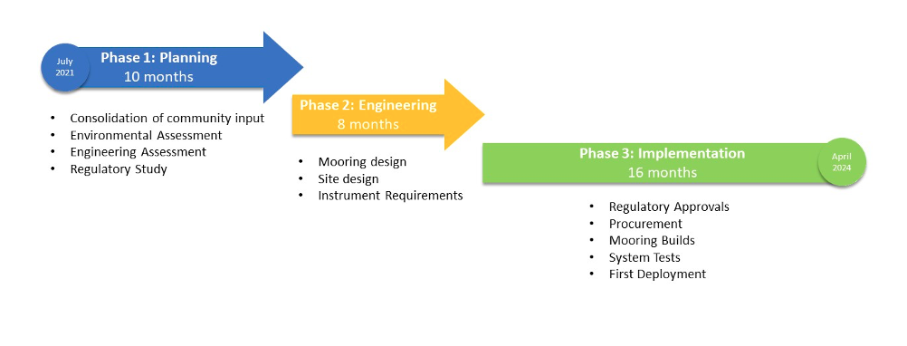
The Pioneer Array, currently sited on the New England Shelf (NES), was conceived within OOI as a re-locatable, coastal array (OOI Science Plan, 2001; OOI Science Prospectus, 2007). At the Fall 2020 American Geophysical Union meeting, the National Science Foundation announced the start of a process for relocation of the Array. After a variety of community engagement activities and two intensive Innovations Labs, it was determined that the Pioneer Array will be relocated to the southern Middle Atlantic Bight (MAB). Existing infrastructure, with some modifications, will be utilized to create a new Array to address compelling science questions at the new site.
The OOI Program is consolidating the community input and preparing for Pioneer relocation activities. The overall effort is complex, and will span roughly 30 months. In order to provide a window for these efforts within the existing operational budget, there will be a pause in Pioneer field activities. Preliminary plans are for the final recovery of the NES Pioneer Array in the fall of 2022 and the initial deployment of the MAB Array in the spring of 2024. The figure below shows the anticipated timeline, with three main phases. Phase 1 will focus on preparatory activities, including environmental and engineering assessments, and a study of regulatory requirements. During Phase 2, the bulk of the engineering and design effort will be conducted. During Phase 3, environmental compliance and permitting will be completed, along with the preparation of the infrastructure for deployment.
Read More
Seaweed May Be a Solution to Faster Climate Mitigation
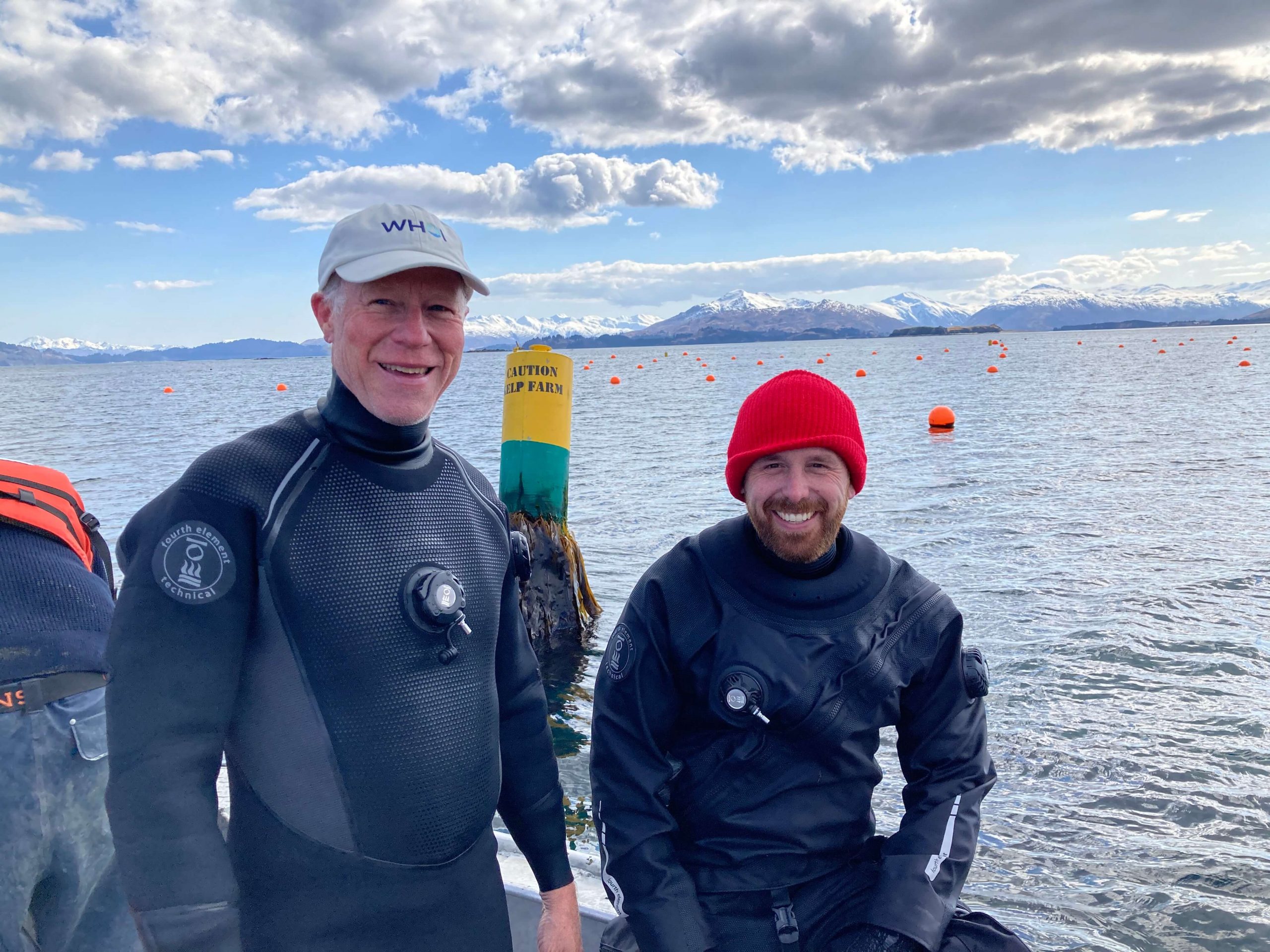
Scott Lindell wants to explore the potential to sequester carbon dioxide and help mitigate the climate crisis by growing seaweed and sinking it to the bottom of the Atlantic Ocean.
Lindell, a researcher at Woods Hole Oceanographic Institution, studies how marine aquaculture can be used for sustainable production of food and fuel. He started his scientific career studying fish farming, and “I’ve been working my way down the food chain ever since,” he says. With funding from the Department of Energy, Lindell’s team has already developed breeds of sugar kelp that yield four times the biomass of typical commercial production.
[media-caption path=”https://oceanobservatories.org/wp-content/uploads/2021/09/Scott-and-Dave-diving-in-Kodiak-1-scaled.jpg” link=”#”]Scott Lindell (l) and David Bailey post-dive on their demonstration kelp farm in Kodiak, AK. Credit: Domenic Manganelli[/media-caption]Seaweeds, like trees, uptake carbon dioxide and convert it into biomass. Oceanographic models predict that if humans sink that seaweed biomass to depths of 1000m or greater, then depending on microbial activity and dissolved oxygen in the water, it may take years or even decades for that carbon to break down. And, because the seaweed would be submerged at great depths, it would take centuries for that carbon to recirculate to surface water and re-equilibrate with the atmosphere.
Seaweed farming, like planting forests, could thus be a natural solution to taking carbon dioxide out of the atmosphere. But compared to planting forests, seaweed farming has the potential to scale up much more rapidly, with the added benefit of not competing for land used for farming crops.
“It would take an area on the order of twice the size of Texas and 40-50 years to create a forest that takes one gigaton of CO2 out of the atmosphere,” says Lindell. “And that forest might only store the carbon for another 40-50 years depending on forest fires, windfall, how fast the trees grow, and other factors.”
But with seaweed farming, Lindell says, “that same one gigaton removal of CO2 could be achieved by an operation as small as the state of Iowa in a year or two’s time, once the farms are developed.”
Lindell and his colleagues have already submitted proposals to study sinking kelp on the U.S. Pacific Coast, where the continental shelf drops off much faster and experiments can be done closer to shore. But he’s also interested in running experiments on the U.S. Atlantic Coast, where commercial farming of sugar kelp (Saccharina latissima) is growing rapidly.
“Our simple demonstration would be to bundle up a ton of seaweed and get it to the deepest parts of the OOI Pioneer Array, about 500 m deep. Then we’d surround it with a benthic lander equipped with cameras and sensors to monitor the rate of degradation and understand the environmental and ecosystem effects,” Lindell explains. He also plans to compare microbial activity and oxygen profile habitability in the sediments around the experimental site with those in sediments from an unimpacted site.
Lindell has started the process of user engagement with the OOI team to find ways to align these experiments with operations at the Pioneer array. “This works better if there’s already some environmental monitoring going on,” he explains. Since most seaweed farming operations on the East Coast are situated in New England waters, the area where Pioneer is currently deployed may be similar to the environments where sequestration efforts might take place.
Lindell believes it’s important to have thorough research on using seaweed as a carbon sequestration method before it becomes a larger operation.
“Iron fertilization has also been considered a climate solution, but early experiments were not carried out very carefully. That was a missed opportunity to learn more about how these solutions could work,” Lindell clarifies. “We want to get ahead of what’s become a building movement and make sure that early efforts are well monitored. We want to do it responsibly.”
Although it will take time to research and develop this carbon sequestration strategy into a commercially scalable operation, Lindell is optimistic about this method’s potential.
“We’ve got to do something,” he says. “I’m excited that this could be a short-term and expedient climate solution.”
Read More