
Posts Tagged ‘Pioneer Array’
VIDEO: Pioneer Observatory Investigates the Continental Shelfbreak
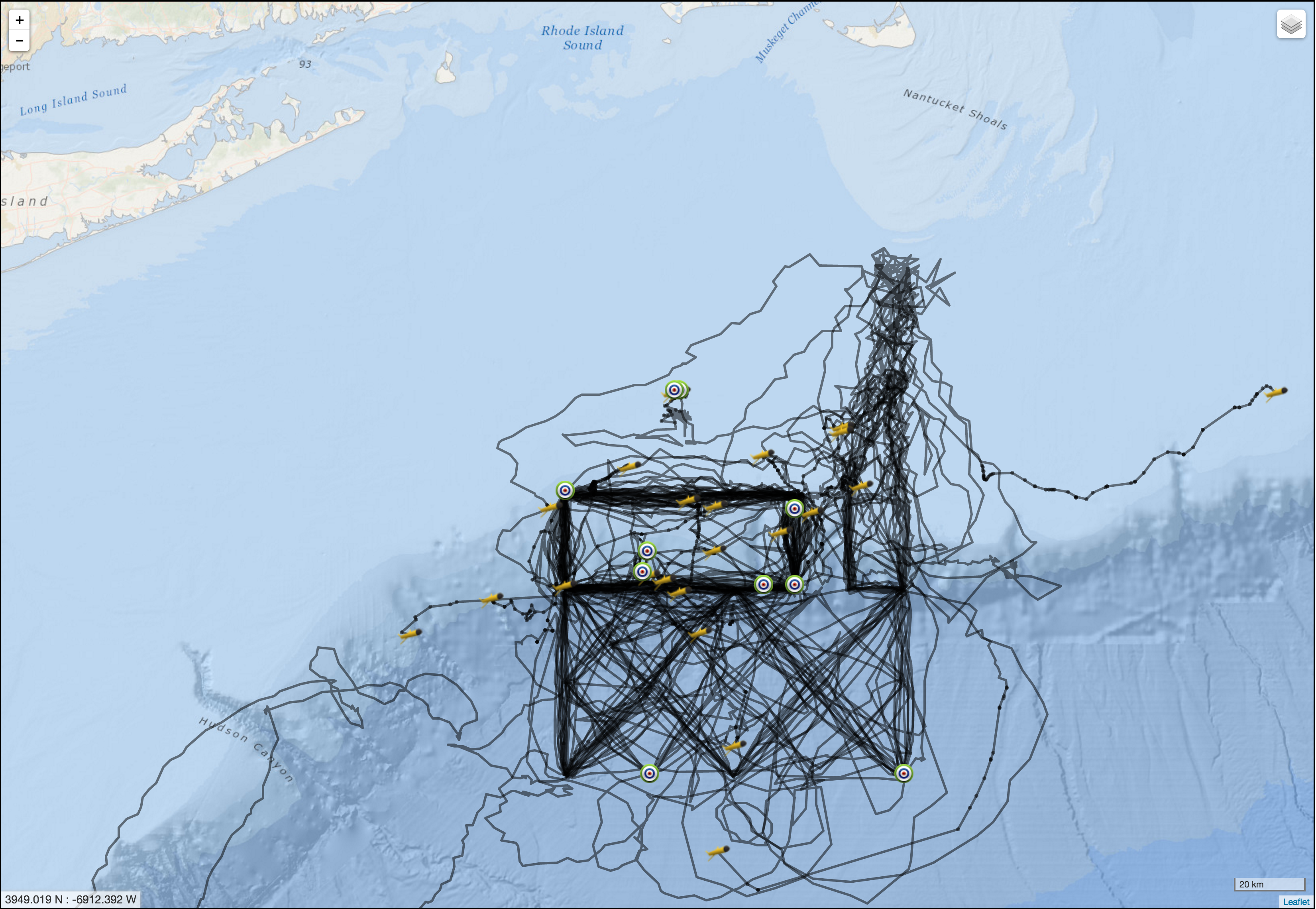
Two years of Pioneer Gliders: A track line view
In July, the OOI CGSN operations team completed another “refresh” of the Pioneer glider fleet. The nominal lifetime for OOI coastal gliders (battery limited) is 90 days. The fleet is refreshed by recovery of exhausted gliders and deployment of refurbished gliders with fresh batteries.
The Coastal Pioneer Array is designed to have 6 Coastal Gliders deployed at a time. Each glider traverses a distinct path within and around the Pioneer Array, sampling an area measuring over 24,000 km2, roughly the size of New Hampshire.
The first three Pioneer Array Coastal Gliders were deployed just over two years ago in May 2014. The map on the right shows a composite of the tracks of all the gliders deployed at Pioneer since those initial deployments.
The impressive results of glider piloting in the complex coastal environment are evidenced by the match between the composite tracks (right) and the planned tracks (left). The tracks that diverge from the plan show the difficulty of maintaining the glider navigation in the face of severe weather and strong currents.
On average, each of the 25 gliders, for which data are shown, were deployed for a duration of 66 days and travelled a distances of approximately 1200 km (750 miles). The longest deployment was 118 days and the glider travelled a distance of 2,230 km (or 1,400 miles). That is roughly the same as driving halfway across the United States!
Congrats to the Pioneer team on a job well done. This is just the beginning!
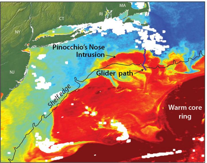
[twocol_one][caption id="attachment_10832" align="alignright" width="276"]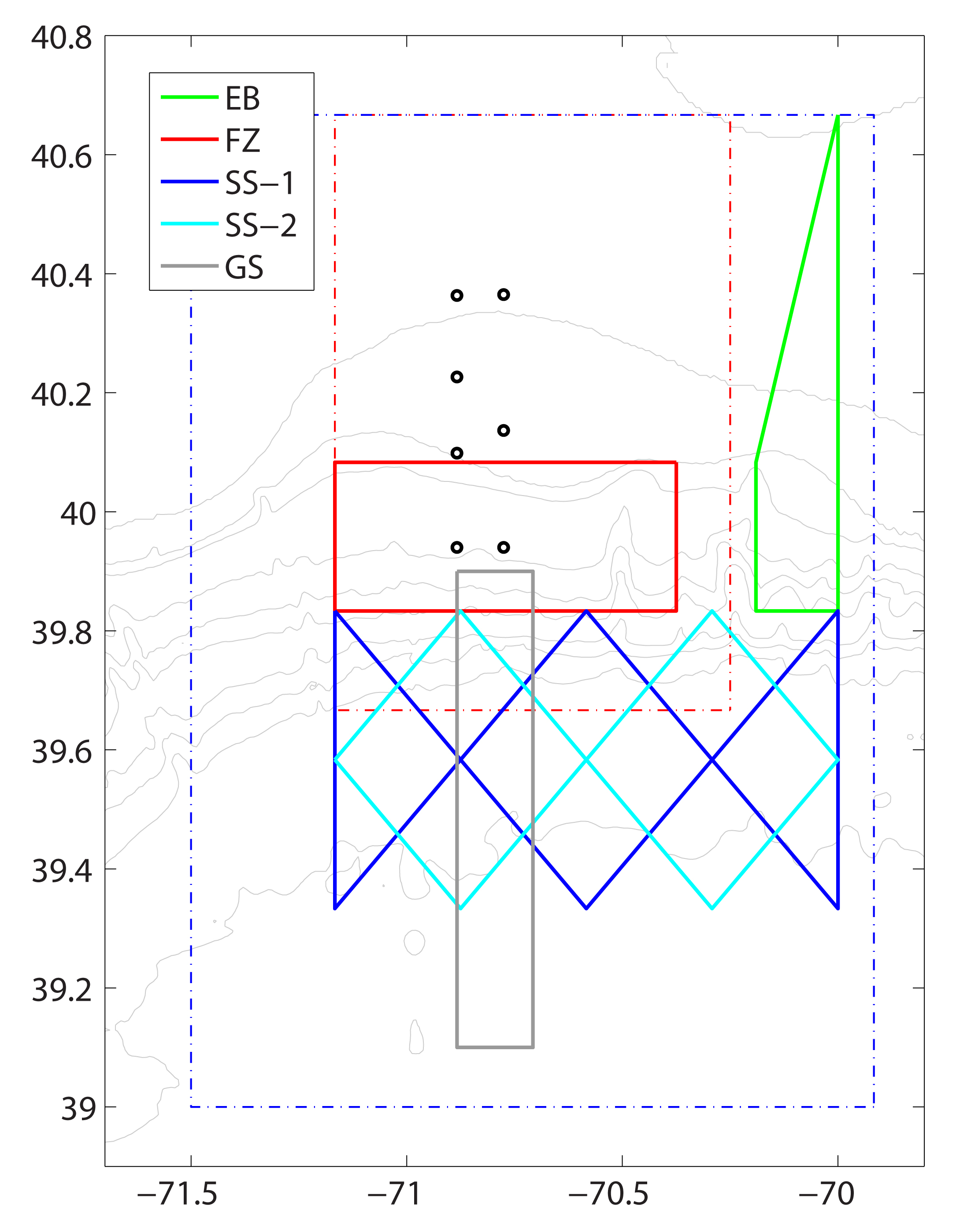 Pioneer Array gliders sample along five glider tracks off the coast of New England. The x- and y-axis are latitude and longitude in decimal degrees. Pioneer Array mooring sites are represented by circles. Boundaries of the glider and AUV operating areas are represented by the blue and red dashed lines, respectively. The five glider tracks are represented by the solid color lines:
-Eastern Boundary (EB) green
-Frontal Zone (FZ) red. Note: two gliders occupy this track
-Slope Sea: SS-1 blue; SS-2 cyan
-Gulf Stream (GS) gray[/caption]
[/twocol_one] [twocol_one_last]
[caption id="attachment_10715" align="aligncenter" width="507"] Each line represents the path of one glider. Glider symbols are the last location of the glider before recovery, green dots represent deployment locations.[/caption]
[/twocol_one_last] Read More
Observing the Oceans, a Photo Tour
Woods Hole Oceanographic Institution (WHOI), the Marine Implementing Organization for the OOI Coastal Pioneer and Global Arrays has created a photo tour of their journey with the OOI from the development and design of these arrays to the completion of construction.
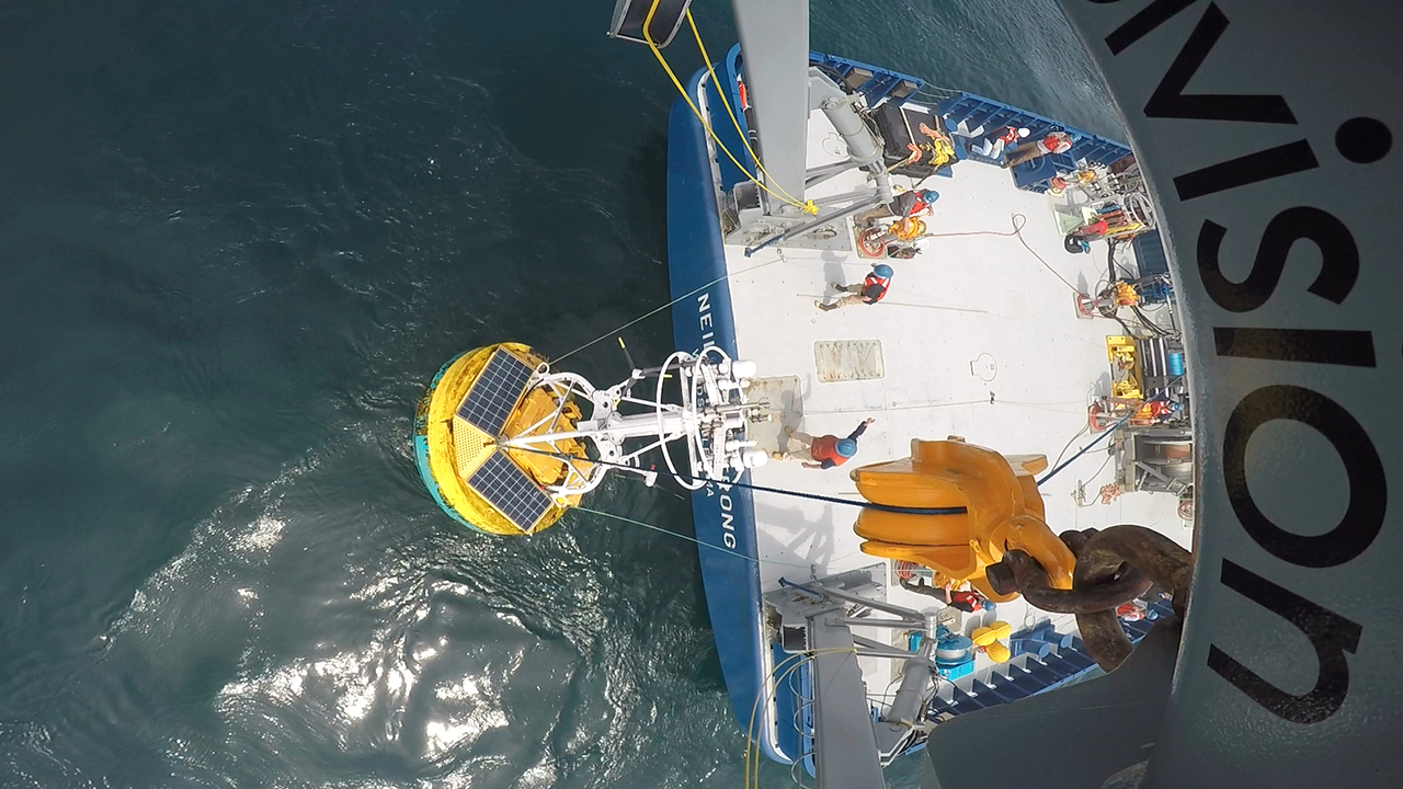
[media-caption type="image" path="/wp-content/uploads/2016/08/000_OOI_intro_GoPro_Armstrong_Paul_Matthias_435553.jpg" alt="The Ocean Observatories Initiative is moving full speed ahead at Woods Hole Oceanographic Institution." link="https://oceanobservatories.org/2016/08/observing-the-oceans-a-photo-tour/000_ooi_intro_gopro_armstrong_paul_matthias_435553"]The Ocean Observatories Initiative is moving full speed ahead at Woods Hole Oceanographic Institution. This unprecedented ocean science project is streaming a wealth of marine data straight from the ocean to the World Wide Web, making it free for anyone to use. In the image above, an OOI coastal surface buoy is recovered from the ocean and hoisted onto the fantail of the research vessel Neil Armstrong. Photo Credit: Paul Matthias, WHOI[/media-caption] [button link="http://www.whoi.edu/visualWHOI/observing-the-ocean"]Check it out![/button] Read MoreWelcome Aboard the R/V Neil Armstrong
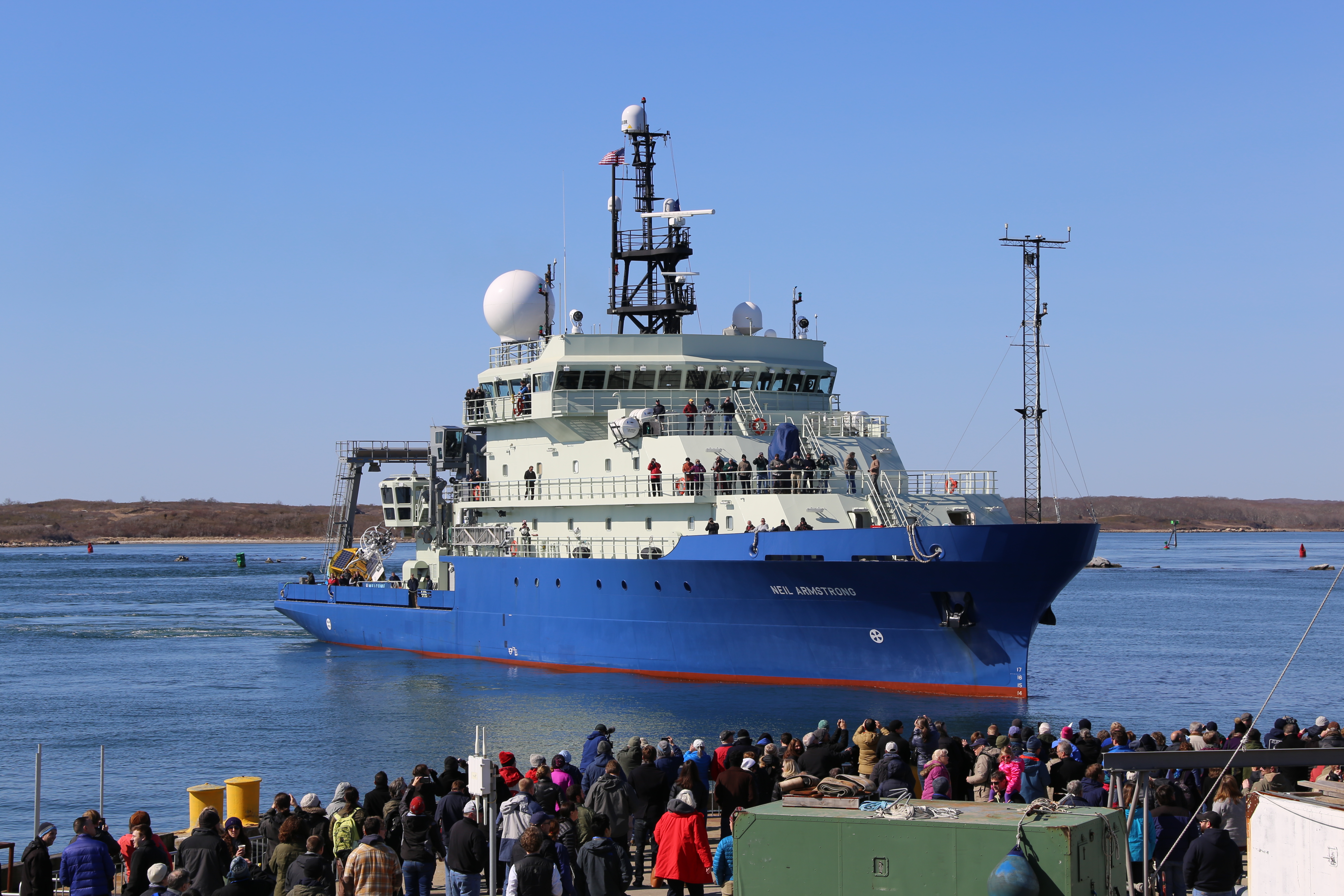
Welcome the newest member of the nation’s research vessel fleet, the R/V Neil Armstrong! Christened after the legendary explorer Neil Armstrong, the new ship will seek to follow his legacy of exploration and scientific discovery. Capable of ranging up to 11,500 nautical miles, the Neil Armstrong is 238 feet long, is equipped with two full-sized labs, and can support up to 44 scientists and crew.
The Ocean Observatories Initiative (OOI) is excited to be amongst the first to use this vessel as the R/V Armstrong recovered two OOI Moorings during its “Science Verification III (SVC III)” Cruise from Virginia to Woods Hole, MA. These moorings were the Coastal Pioneer Array Central Surface Mooring and Upstream Inshore Profiler Mooring located on the continental shelf south of Martha’s Vineyard.
Home-ported at the Woods Hole Oceanographic Institution, the Armstrong will be enlisted for future Pioneer Array maintenance cruises, as well as cruises to the Global Irminger Sea Array southeast of Greenland.
The Coastal Pioneer and Global Irminger Sea Arrays are the OOI’s two arrays in the North Atlantic. The Coastal Pioneer Array is one of two coastal arrays and is located along the continental shelf-break front off the coast of New England. The Pioneer Array’s oceanographic and meteorological observations from the highly productive region along the continental shelf-break off the coast of New England. This array allows scientists and educators to examine several important coastal processes, including shelf break fronts, frontal upwelling, and the role of filaments and eddies in cross-shelf exchange of parameters such as nutrients, heat, and biomass.
The Global Irminger Sea Array is one of four global sites in the OOI focusing on the critical, yet under-sampled, high-latitude regions of the Pacific and Atlantic. It includes a network of moorings that will support sensors for measurement of air-sea fluxes of heat, moisture and momentum; physical, biological and chemical properties throughout the water column.
The OOI, a project funded by the National Science Foundation, is an integrated infrastructure of science-driven platforms and sensor systems that measure physical, chemical, geological, and biological properties and processes from the seafloor to the sea surface. It was designed to provide data to address scientific challenges such as climate and ecosystem health.
Please continue to visit the OOI Website for the latest news on the program, sign up for our Mailing List, or submit comments or question through the HelpDesk.
Read MoreGulf Stream Ring Water Intrudes onto Continental Shelf Like “Pinocchio’s Nose”
Ocean robots installed off the coast of Massachusetts have helped scientists understand a previously unknown process by which warm Gulf Stream water and colder waters of the continental shelf exchange. The process occurs when offshore waters, originating in the tropics, intrude onto the Mid-Atlantic Bight shelf and meet the waters originating in regions near the Arctic. This process can greatly affect shelf circulation, biogeochemistry and fisheries.
In 2006, scientists using satellite imagery observed an elongated body of warm water from a Gulf Stream warm-core ring intruding along the shelf edge, extending hundreds of miles from Massachusetts towards Cape Hatteras, NC.
“A lot of people were surprised by this,” said Weifeng ‘Gordon’ Zhang, associate scientist at Woods Hole Oceanographic Institution (WHOI), and lead author of the study published today in Geophysical Research Letters. “Normally, the Gulf Stream water, which is very warm and buoyant, doesn’t come in direct contact with the water on the continental shelf, which is much colder. There is a cascade of potential implications that need further study.”
Until now, scientists had been unable to study the phenomenon because satellites can only sense the ocean surface, and no data about the structure of the intrusion water below the surface were available. However, in April 2014, water column data in this area became available from preliminary deployments from the National Science Foundation-funded Ocean Observatories Initiative (OOI). Specifically, autonomous vehicles called “gliders” that collect data along a pre-defined path in the ocean, were deployed at the OOI Pioneer Array site south of Cape Cod. Zhang and his colleagues used preliminary glider data, collected from April through June 2014 and publicly available on the OOI website, to generate the first profile of the complex, layered masses of water at this vital point in the ocean.
“The edge of the continental shelf is a key location where dense, nutrient rich water ‘upwells’ to the surface, stimulating growth at the base of the food web,” said co-author Glen Gawarkiewicz, a senior scientist at WHOI. “This water is normally sandwiched between colder, fresher water on the shelf and warmer Gulf Stream waters offshore. Understanding changes in this region has important societal and economic implications.”
Satellite imagery shows five similar-looking intrusion events have occurred between 2007-2014 in the winter and spring seasons. Zhang and Gawarkiewicz have dubbed the events “Pinocchio’s Nose Intrusions” (PNI) because the warm water intrudes onto the shelf and continues to “grow” for hundreds of miles, moving in the opposite direction from the northeastward movement of the Gulf Stream.
Until this new research was conducted, one proposed explanation was that the warm waters were swept up in the shelf break jet, a current that moves toward the southwest direction along the shelf edge. Zhang calls this “the deception or lie” of the Pinocchio’s Nose Intrusion. “If the intrusion was caused by the shelfbreak jet,” said Zhang, “this feature would most likely be a very thin, superficial feature on the surface.” In contrast, thanks to the data collected by the OOI Pioneer Array gliders before and after the PNI formed, the scientists determined these intrusions are nearly 100 meters deep, extending almost to the seafloor.
Rotating warm core rings form in the deep ocean and eventually pinch off from the Gulf Stream, heading in a northwest direction onto the shallower continental slope. The outer limbs of the rings hit the slope first, and are squeezed by the rising sea floor. Once reaching the shelf, they follow the shelf edge extending to the southwest forming the long nose shape. Eventually, the extension stops, and thin filaments coming out of the north side of the nose penetrate further onto the shelf.
The OOI Pioneer Array data also allowed scientists to understand the complexities of what is driving the density of the various water masses at this unique location. Under normal conditions, the density in the region is controlled by the salinity. The shelf water is fresher than offshore water and therefore more buoyant than saltier offshore water. However, during a PNI event, the shelf water is less buoyant than the offshore water because of a huge temperature difference–approximately 25-30 degrees Fahrenheit–between the shelf waters and the intrusion waters.
“Because the Gulf Stream water is so outrageously warm, density now is controlled by the temperature, and the intrusion water is more buoyant, despite being saltier,” said Zhang.
The changes in temperature, density and circulation all have major implications for the fisheries in the area.
“I showed the glider data to a group of commercial fisherman back in April, in Rhode Island, and they were very surprised,” said Gawarkiewicz. “They couldn’t believe the temperature can change by that much, that quickly.”
The scientists believe the PNI process might assist in the transport of young fish, like American eel, across the shelfbreak barrier and onto the shelf, where they can swim toward coastal estuaries. For American eels, this is an important step of their reproductive migration journey and crucial for their survival. The baby eels have to make it from the spawning ground in the tropics to their estuarine and freshwater habitats on the US northeast coast in the first year of their life. The direct intrusion of the Gulf Stream water onto the shelf can help them reach their destination without being swept away, and may increase their survival rate. But for other species, the intrusion might bring in the low nutrient Gulf Stream surface water and suppress the upwelling of cold, dense, nutrient-rich water, and thereby reduce biological productivity in a region that is otherwise known for its fertile fishing grounds.
“I just find it extraordinary that the Pioneer Array gliders were out for a month, and we have already identified a new shelf break exchange process,” said Gawarkiewicz. “It just goes to show how much more we have to learn in the shelf-wide ecosystem.”
“I am very proud of our WHOI scientists, Weifeng Zhang and Glen Gawarkiewicz,” said Representative William Keating (D-MA). “Their discovery serves as a reminder of the critical need for continued and more frequent ocean observation, as well as the interconnectedness of the health of our oceans and the health of our marine ecosystems. WHOI has long been an international leader in oceanography, with groundbreaking research unveiling countless discoveries that have changed the field. This breakthrough is no different. As we continue to study and understand the magnitude and impacts of the changes of ocean temperatures and circulation, WHOI’s research and resources will be invaluable.”
###
The research was funded by the National Science Foundation.
The Woods Hole Oceanographic Institution is a private, non-profit organization on Cape Cod, Mass., dedicated to marine research, engineering, and higher education. Established in 1930 on a recommendation from the National Academy of Sciences, its primary mission is to understand the ocean and its interaction with the Earth as a whole, and to communicate a basic understanding of the ocean’s role in the changing global environment. For more information, please visit http://www.
Ocean Observatories Initiative to Deploy First Infrastructure in the Atlantic
The OOI Program this month will install the first moored infrastructure in the Atlantic Ocean on the continental shelf and slope south of Martha’s Vineyard, MA.
Read MoreScientists Uncover Diversion of Gulf Stream Path in Late 2011

Warmer waters flowed to shelfbreak south of New England
Read MoreOcean Observatories Initiative (OOI) Program Successfully Completes At Sea Equipment Test

The Ocean Observatories Initiative (OOI) in April successfully recovered equipment deployed for at sea tests in the waters south of New England.
Read MoreInformation on East Coast Activities and Pioneer Array

The Ocean Observatories Initiative program currently is conducting At Sea Tests of equipment off the New England Coast.
Read MoreUniversity of Rhode Island Students Learn About Ocean Observatories Initiative
University of Rhode Island undergraduates participating on the Research Vessel (R/V) Endeavor’s 500th research cruise last month learned about the OOI program.
Read More