
Posts Tagged ‘RCA’
RCA’s Ninth Expedition: Best Laid Plans
Written by Deborah Kelley, PI of the Regional Cabled Array, September 17, 2023
The Regional Cabled Array, spanning the Cascadia Margin and Juan de Fuca tectonic plate and water depths of ~260 ft to 9500 ft, is an engineering marvel. It is the most advanced underwater observatory in the oceans comprised of >900 km of high power- and -bandwidth submarine fiber optic cables, a highly diverse suite of >150 instruments, and state-of-the-art moorings with instrumented profilers, which since 2014 have traversed >50 million meters of ocean water! The underwater substations and instruments are installed in some of the most extreme environments on Earth, including the most active submarine volcano off the Oregon-Washington coast ‘Axial Seamount’. Here, extension cables traverse glass covered lava flows and instruments are inserted into underwater, acidic hot springs, hot enough to rapidly dissolve aluminum and melt lead. Profiling science pods on moorings that traverse ocean depths from ~650 ft to 16 ft nine times a day, must be ‘smart’ enough to keep “their heads down” when storms, common in the waters of the NE Pacific Ocean, create waves reaching 30 feet in height or more. Yet, it is within these environments that the cabled observatory has thrived, largely due to its design, rigorous testing, and the hard work of the RCA Team, and Jason and Thompson crews during the annual operations and maintenance expeditions, such as the one nearing its end now: VISIONS’23.
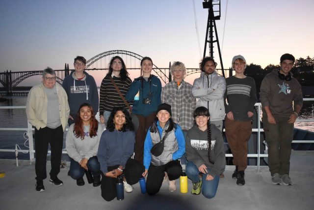
[media-caption path="https://oceanobservatories.org/wp-content/uploads/2023/09/Katie_Studenst_sm-20230908_200403_startL4_ME-copy-scaled-1.jpg" link="#"]First time RCA Chief Scientist Katie Bigham (top row, second from left) with Co-Chief Scientist J. Nelson (far left), RCA technician Andrew Paley (top row, far right) and Leg 4 VISIONS students. Katie was a VISIONS’14 student. Credit: M. Elend, University Washington, V23.[/media-caption]Planning for the RCA 2023 cruise began over a year ago as there is a high demand for NSF’s global class ships that operate throughout the worlds’ oceans. Scheduling is a complex process with lots of moving parts involving minimization of transit lengths, awareness of optimum weather windows, and researchers’ schedules. As soon as lasts year’s cruise ended, RCA instruments recovered in the Fall of 2022, were sent back to vendors for calibration and refurbishment, parts and cables were ordered, and the RCA teams’ eyes were already looking to this year. By late Spring, most of the refurbishment and integration testing of platforms and instruments was complete, the four Legs were planned out in detail, and the nearly 144 berthing assignments were finished. The careful layout of equipment on the aft deck of the Thompson was of critical importance, with nearly 200,000 lbs of gear on the fantail and the need for deck space free of gear to allow for mooring cables to be recovered and redeployed.
So that brings us to now, nearing the end of Leg 4, which will end on September 18 when the Thompson arrives back to Newport, Oregon. Working at sea is just tough, no way around it, and best laid plans are often adjusted before even leaving port (such as happened at the start of Legs 1 and 3) as the weather gods do not care about our schedule. The prior three Legs experienced numerous perturbations due to the loss of a week of operational days when the ROV Jason could not dive due to bad weather and additional loss of time due to ROV issues. Plans were adjusted on the ‘fly’ over and over again to best accomplish all of our goals, including the recovery and re-installation of >100 instruments. Because of this, some work was pushed out into Leg 4, an already complicated Leg because it was especially dependent on having good sea state conditions due to the planned installation and recovery of two deep profiler moorings, the largest of which rises >8000 ft above the seafloor at the base of Axial Seamount.
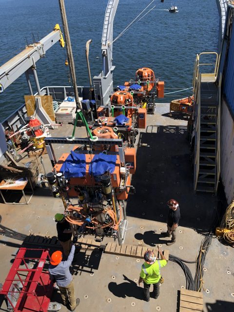
[media-caption path="https://oceanobservatories.org/wp-content/uploads/2023/09/Float.jpg" link="#"]The float for the Deep Profiler mooring at the Oregon Offshore site being brought onboard the Thompson. Credit: M. Elend, University of Washington; V23.[/media-caption]Almost immediately, Leg 4 plans were adjusted following the first operation – the recovery and reinstallation of the Deep Profiler Mooring at the Oregon Offshore site. The communications and power ‘dock’ at the base of the mooring would not respond after plugging in the seafloor extension cable that connects it to a small substation (junction box) on the seafloor. While the engineers tested various aspects of the cable, and puzzled over the cause, the RCA team continued their work at the Slope Base site. There, the Deep Profiler mooring cable was cleaned, and the instrumented profiling vehicle deployed in 2022 was replaced. Following this operation, the Thompson transited ~ 18 hrs to the base of Axial Seamount, where, instead of turning the mooring, it was decided to just swap out the vehicle, similar to Slope Base.
[media-caption path="https://oceanobservatories.org/wp-content/uploads/2023/09/getting-ready-to-bring-in-the-cable.sm_.PD01B_20230909_132549_recovery_ME-copy-scaled-1.jpg" link="#"]RCA engineers and ship crew getting ready to spool cable onboard from the Offshore Deep Profiler Mooring. Credit: M. Elend, University of Washington, V23.[/media-caption]With this work complete, a series of dives was planned to support researchers’ projects funded by the National Science Foundation outside of the Ocean Observatories Initiative. These dives were to include sampling of hydrothermal vent fluids to investigate viruses and microbes in these extreme environments, the recovery and installation of cabled CTD instruments to test the hypothesis that highly saline fluids are flushed from beneath the seafloor shortly following an eruption, and the recovery of a cabled multibeam sonar (COVIS) focused on making unique fluid flux measurements in the ASHES hydrothermal field. Time allowing, equipment on the Thompson would be used to “talk” to an acoustic array (FETCH) installed in the volcanoes’ caldera for investigation of deformation within this highly active volcano.
There was, however, a small window to complete this work. After investigation of the Deep Profiler Mooring at the Oregon Offshore site, it was determined that the Thompson would need to transit nearly 300 miles back to this area, to install a new extension cable, and/or recover and redeploy the mooring with the one just recovered at the beginning of Leg 4 – an exercise that could take 2-3 days. Indeed, Jason had other ideas because while working at the summit of Axial, there was an issue with the specialized hydrothermal vent sampler on the vehicle, followed by a failure of the power system, preventing more dives. The Jason team worked very hard overnight to fix the power supply, but with ever decreasing time to get the Deep Profiler work done back on the margin, it was decided to abandon remaining work at Axial (a very tough decision as this would impact researchers work over the entire next year) and head to the Offshore site. This also allowed optimal use of the transit time to thoroughly test the repaired power system for Jason. It also provided time for the APL engineers to ready a new extension cable for the Deep Profiler mooring, hoping that this simple fix would solve the problem, and to catch up on much needed sleep. With huge relief, the replacement of the extension cable did the trick on the first dive at the Offshore site. The docking station powered up and the vehicle completed its test profiling run — opening up a three-day window for additional work.
[media-caption path="https://oceanobservatories.org/wp-content/uploads/2023/09/ratail-sulis_20230916210321_rattail_probe_closeup.jpeg" link="#"]A rattail fish came to investigate the UFO fluid sampler as it obtained fluids for Dr. Rika Anderson at Marker 113, a diffuse flow site in Axial Caldera. Credit: UW/NSF-OOI/WHOI, Dive J2-1559, V23.[/media-caption]With a sigh of relief and desperately wanting to support the external researchers work, Chief Scientist, Katie Bigham, asked Captain Eric to turn the ship around and head back out to Axial Seamount. So away they went, following the same track line they had completed less than 24 hrs before. During the next 34 hrs, Jason pounded out the dives and completed all but the FETCH work, before it was time to once again head back to Slope Base to complete two final tasks.
The above description is only part of what goes on during the various legs of these RCA expeditions. It is hard to convey what it is like to be a Chief Scientist on an RCA cruise. As with this cruise, decisions must be made rapidly, but also strategically, with an eye towards the end of a leg and cruise – “Will this decision prevent other work from happening? What is the weather going to be like in 2-3 days? What is the status of equipment? How are the students doing and how are their projects going? Do they need help? Is the team getting enough sleep? Should we transit to another site to help with this? On and on it goes…Awareness of these questions and outcomes are always in a Chief Scientists’ thoughts and are combined with the everyday tasks of writing plans for the next day and operational reports.
This was Katie’s first time being a Chief Scientist. She has done an exceptional job making adjustments to our “best laid plans” on a cruise that has been one for the books in the near decade of RCA operations and maintenance expeditions.
For more information on the RCA’s ninth operations and maintenance expedition, visit here.
Read More
RCA Embarks on a 41-day Operations and Maintenance Expedition
Watch live video here.
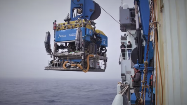
The numbers are remarkable for the Regional Cabled Array’s (RCA) Operations and Maintenance Expedition that left Newport, Oregon aboard the R/V Thomas G. Thompson on Sunday August 13. Because of its complexity and the need to move 100 different instruments, the expedition consists of four legs over 41-days. The legs are separated by ~2-3 days port call at NOAA Marine Operation Center in Newport, Oregon. A science team of 12 is conducting the scientific operations, with their work supported by an engineering team of 20 (not all onboard). The Remotely Operated Vehicle (ROV) Jason, operated by a team of 12 from the Woods Hole Oceanographic Institution, is recovering and deploying instrumentation on the RCA for the duration of the expedition.
Finally, 25 students in the University of Washington’s VISIONS Program are onboard during various legs to gain real sea-going experience and work side by side with the scientific team. Additionally, six other guest participants will be onboard, including a children’s author, engineers, and scientists.
The RCA annual expedition is always an exciting opportunity to watch real-life operations at sea. Operations will be live-streamed here. Details about the expedition, who’s involved, and what’s happening and planned can be found here. Daily updates can be found here.
[video width="608" height="1080" mp4="https://oceanobservatories.org/wp-content/uploads/2023/08/Thompson-loading.mp4"][/video] Read MoreSoundscape Ecology Through Automated Acoustic-Based Biodiversity Indices
Soundscape Ecology Through Use of Automated Acoustic-Based Biodiversity Indices: A Test Using RCA Broadband Hydrophone Data. Adapted by OOI from Ferguson et al., 2023.
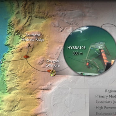
[media-caption path="https://oceanobservatories.org/wp-content/uploads/2023/07/Screenshot-2023-07-27-at-3.53.41-PM.png" link="#"]Figure a) Location of Regional Cabled Array broadband hydrophones used in this study. b) Acoustic Complexity Index associated with mammal calls, fish sounds, and anthropogenic noise. (After Ferguson et al., 2023).[/media-caption]Ferguson’s et al., 2003 paper explores the use of myriad biodiversity indices, generated by automated acoustic classifications, using data from three of the Regional Cabled Array (RCA) broadband hydrophones. As the authors point out, human in-the-loop evaluation of marine species and anthropogenic noise from very large data volumes generated by passive acoustic sensors is formidable. Yet, identification of marine organisms and anthropogenic noise is increasingly important for biodiversity conservation and ecosystem monitoring. Automated biodiversity indices have been utilized in terrestrial environments, but only limited studies have used machine learning to study soundscape ecology in marine systems. This study used broadband hydrophone (HYDBBA) data from Slope Base on the Shallow Profiler Mooring (200 m water depth and ~ 100 km offshore), at Oregon Offshore (580 m water depth and ~ 72 km offshore), and the Oregon Shelf site (80 m water depth and ~ 16 km offshore) (Figure 28a) to examine seven diversity indices. Note, these study sites are valuable to making progress in soundscape ecology because the Cascadia Margin is characterized by very high biological productivity impacted by the California current, it is the site of intense shipping lanes, and because of the availability of continuous, real-time acoustic data streams provide by the RCA.
In this initial study, Ferguson et al., evaluated one month of data from the three sites: January 2017 for HYBDDA 103 and 106 and April 2018 for HYBDDA 105. Five minute files were used with 7,101 files for Slope Base, 4,725 files for Oregon Offshore, and 6,410 files for the Oregon Shelf. Data from these instruments had been previously annotated, providing ground truthing for machine learning results. Periods of vocalization of marine mammals occurred less frequently at Slope Base. Three months of data were reviewed to examine periods of mammal vocalizations and anthropogenic sounds.
Identifying the relationship between numerous acoustic indices and species characteristics is complex and requires attention to a significant number of factors and computation of multiple tests, as described in detail in this paper. The Acoustic Complexity Index (ACI, Figure 28b), is generated from an algorithm to quantify biological sounds based on intensity, it is the most commonly used index to assess acoustic indices in marine systems, and has been demonstrated useful in identifying species diversity. Results from this work show that ACI measurements increased during vocalizations by dolphins and sperm whales. However, evaluation of the seven indices show that biodiversity cannot be explicitly determined from any single acoustic index. A significant finding from this study is that true assessment of large-scale ecosystem health and changes in indicator species, which may be due to differences in seasonal and interannual variability, requires co-located physical and chemical oceanographic data. The authors note that the RCA and Endurance Array instrumentation provides “an ideal scenario for accurately monitoring system health”.
_______________________________________________
Ferguson, E.L., H.M. Clayton, and T. Sakai (2023) Acoustic Indices Respond to Marine Mammal Vocalizations and Sources of Anthropogenic Noise. Frontiers in Marine Science. 10:1025464; doi: 10.3389/fmars.2023.1025464.
Read MoreRegional Cabled Array VISIONS Expedition
RCA Science and Data in K12 Classrooms
Dr. Kareen Borders, Executive Director, STEM Instruction and Outreach, South Kitsap School District and Executive Director of West Sound STEM Network and Dr. Deb Kelley, Professor, School of Oceanography, University of Washington and Director of the Regional Cabled Array, Ocean Observatories Initiative (OOI) teamed up to bring Regional Cabled Array science and data into K12 classrooms in northwest Washington.
After holding a series of curriculum development workshop, classroom units and lessons are now available on the Regional Cabled Array’s Interactive Ocean website. The teaching tools are are the products of a pilot program, funded by the National Science Foundation, that brought together a professional learning community of West Sound STEM Network K12 teacher leaders from northwest Washington school districts, and private and Tribal schools, in partnership with University of Washington, School of Oceanography scientists. They engaged in a series of K12 Ocean Observatories Initiative (OOI) education curriculum development workshops centered on marine science through use of Regional Cabled Array data.
This cohort of middle and high school teachers developed a series of OOI-integrated STEM Units utilizing stunning imagery from the OOI/ University of Washington Interactiveoceans website and live data from more than 150 instruments streaming from the Regional Cabled Array underwater observatory off the coast of Oregon. The use of rigorous and relevant instructional practices and culturally relevant pedagogical design connects students to technology as a tool for meaningful STEM learning and exploration of STEM career pathways.
The workshops resulted in cloud-based educational packages that cover Plate Tectonics and Volcanoes utilizing the Juan de Fuca Plate and Axial Seamount as prime examples, geohazards focused on seismicity along the Cascadia Subduction Zone and tsunamis, and climate change with an emphasis on heat waves. To access and use the workshop material, visit RCA’s link here.
Read MoreInternal Tide Impacts on Ocean Circulation
Internal tides (ITs) have critical roles in determining the meridional overturning circulation and oceanic heat budget. The Regional Cabled and Coastal Endurance Arrays data are making it possible to identify the impacts of changes associated with the ITs.
Read MoreMarine Heatwaves
The Coastal Endurance, the Regional Cabled, and the Global Station Papa Arrays were key in identifying and monitoring the approach of a marine heatwave known as the “Blob” and its links to multiple ecosystem impacts on the US west coast.
Read MoreAccelerating Marine Ecological Research
Mid-trophic level organisms, such as zooplankton and forage fish, play a critical role in mediating energy transfer from primary production to top predators in the marine ecosystem. Using Coastal Endurance Array echosounders, scientists are observing long-term changes in the distribution and abundance of this important part of the marine food web.
Read MoreRCA Technical Wizards: The Saga of Repairing an RCA Primary Node
Chuck McGuire and Larry Nielson were able to take a cabled power and communications substation that sat inoperable on the dark, cold seafloor of the Pacific for two years and make it work again. The odds were against them. There’s usually less than a 50-50 chance to make a complex technology operational again after this length of inactivity – inactivity compounded by the extreme pressure, cold temperature, and biofouling that occurs on the bottom of the Pacific Ocean. But these two engineering geniuses succeeded in repairing, rebuilding, and ultimately reconnecting Primary Node 1B (PN1B), which provides power to the Southern Hydrate Ridge portion of OOI’s Regional Cabled Array (RCA).
[embed]https://vimeo.com/user110037220/pn1b[/embed]It was an arduous, complicated journey, fraught with delays outside of the engineers’ control. The recovery, repair, and reinstallation took two years to complete. We share some of the highlights below for they illustrate the many challenges of operating seafloor cable infrastructure on an active tectonic plate in the Pacific Ocean.
Chuck McGuire, a senior principal engineer, is the chief engineer for the RCA and principal investigator for the engineering portion of the RCA, which is conducted at the University of Washington’s Applied Physics Laboratory (APL). Larry Nielson is a field engineer three at APL. They have been working on the RCA project since its inception in 2009 (Construction and deployment began in 2013).
When PN1B failed in 2020, the duo was stymied at first. They had to call in a variety of people with different skills to recover, rebuild, and redeploy it.
“Restoration of the PN1B is really a testament to the engineering that went into these nodes, which are good and work well under very harsh conditions, “explained McGuire. The Primary Nodes were designed and built by L3 Maripro with oversight by the APL Engineering team.
A Cable Fault Causes Power Loss
The saga began during RCA’s annual maintenance expedition in summer 2020. Everything was smooth sailing until suddenly the science team aboard the R/V Thomas G. Thompson learned of a cable fault on the southern cable line, which had shorted out. McGuire and team instantly went into troubleshooting mode and determined that the problem was in PN1B, which powers the Southern Hydrate Ridge section of the 900 kilometers of cable that comprise the RCA.
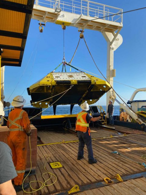
[media-caption path="https://oceanobservatories.org/wp-content/uploads/2023/03/202108-Recovery-of-Failed-PN1B-scaled.jpg" link="#"]Recovery of failed PN1B. Credit: NSF/OOI/UW.[/media-caption]Luckily, they were able to divert the ship, the R/V Thomas G. Thompson, to the PN1B location to investigate. McGuire was on shore at the Shore Station in Oregon where he could troubleshoot the power system. McGuire worked with a team onboard to use the Remotely Operated Vehicle (ROV) Jason, operated by the National Deep Submergence Laboratory of the Woods Hole Oceanographic Institution, to unplug and plug back in the science interface assembly (SIA) that provides power and communication to secondary infrastructure on the array (e.g. extension cables, junction boxes, instruments, and moorings). The SIA was attached to and powered by PN1B. The SIA wasn’t the cause of the short, so the next step was a visual inspection of the cable with the ROV, tracing the cables back from the node to see if there was any external aggression or damage to that cable. None was seen. The next step was to determine where the power was lost. By controlling the power from the Shore Station and sending “tones” (an oscillating frequency) down the cable, they were able to isolate the affected area. They determined that the PN1B was no longer transmitting any power to the southern cable line running east of the node.
McGuire and Nielson set to figuring out how to replace the damaged node with a spare. A specialized cable ship would be required. A request for proposal was released and the cable ship IT Integrity was secured.
With a cable ship lined up, the engineering team set about reconfiguring the Primary Node and a replacement SIA, which would be plugged into PN1B when both were back on the seafloor. The assembly was complicated and required reconfiguration of all the optics in the SIA’s interior. “Larry was able to get the SIA unassembled and rigged up in a way that made it possible for me to go in and remove and replace the components that needed to be replaced,” explained McGuire. “All of this was unexpected work, which took time, and there was much aggravation. But Larry had some amazing solutions to some interesting rigging problems.”
The two engineers had to rely on their experience to tear down the SIA and then reconstruct it. Their challenge included having to create specialized tools to get into extremely tight spaces. McGuire likened the work to repairing a car engine, where one slowly takes things off, working through the engine until finding the problem. The difference between the Primary Node and a car, however, was that spare parts to fix any issues found weren’t readily available and would have to be manufactured if needed. Here, again, the skill, experience, and tenacity of this duo were called into play. After taking the node apart and putting it back together again, they are now experts.
Their work was driven by a tight schedule needed to get the node and SIA ready for the next RCA recovery and deployment cruise in July 2021. The plan was to have the cable ship work simultaneously with the ROV Jason that was aboard the Thompson. During the 2021 expedition, Jason successfully unplugged and recovered the SIA. The cable ship Integrity then dropped a recovery line next to the node and Jason hooked the recovery line to the node. The cable ship recovered the node, returned it to the dock in Newport, where it picked up the replacement node. All seemed to be going well and on schedule.
While the transit and offloading were taking place, the team had tied the cables to a surface buoy to keep them accessible for reconnection to the new node. When back at the buoy, engineers on the Integrity began the process of jointing—essentially splicing—the tied-off cables and attaching them to new cables connected to the replacement node. When all was connected, the next step was to use a cable winch to lower the cables down to the bottom. Unfortunately, during deployment of the replacement PN1B, the system was damaged which resulted in a shunt fault. Tests indicated the damage was most likely in or very close to the cable termination assembly (CTA) making a repair with the node, at that time, not possible. The replacement PN1B was recovered to deck.
Rather than admit defeat, McGuire came up with the idea to bypass the replacement node and connect the cable downslope from the west to the eastern cable together to provide power and communication to Primary Nodes PN1C and PN1D. McGuire figured that if optical power was too high, communications would fail since PN1B would not be in the system to attenuate the signal. After a few quick calculations, McGuire determined what the attenuation needed to be in the line so that the power wasn’t too high to prevent communication down the cable. The required attenuators were driven down to Newport while the ship headed to port to retrieve the critical parts. The cables were then jointed with the attenuators in the optical circuit, restoring about 65 percent of the power and communications lost to the cable system initially and allowing RCA instruments and moorings at the Oregon Offshore and Oregon Shelf sites to become operational again. The maneuver was innovative and an engineering feat.
Upon returning to the lab, the team faced other challenges. They had to reverse engineer a CTA. Because many of the parts could not be seen without destroying other critical parts, a CT scanner was used to scan its many parts, and point clouds (discrete set of data points in space) were developed. These cloud points were then fed into Solidworks, a software program, to create models of each part that needed to be machined or refurbished.
“CTAs are a very complex component,“ explained McGuire. “They terminate a cable into an object that must retain its watertight integrity at over 3000 meters water depth, while withstanding 35,000 pounds of pulling force and protecting the optical fibers in the cable. Also, there’s not a rock solid on-land way to test its water tight integrity once it’s been built with the cable, ready for deployment.”
In getting ready for the next deployment attempt, the engineering duo encountered other obstacles from COVID-related delivery delays to manufacturers who no longer manufactured needed components. They persevered. The team tore down the replacement node a second time and rebuilt it, with the same deliberate process given the first replacement node. Once completed, they took the replacement node through a complete battery of tests, making sure that it was capable of being powered up, could communicate with the SIA, and provide power to the cabled system. They then shipped the node to Portland to be loaded on a larger cable ship, the C.S. IT Intrepid.
In June 2022, the replacement node was again ready for deployment. McGuire boarded the Intrepid with field engineer Paul Aguilar to oversee deployment. After two days of bad weather, the ship finally was on site. The deployment went without incident except that the node landed 400 meters short of where it was to connect to the cable. To reposition the node, PN1B would have to be lifted back on deck and four kilometers of cable would have to be “peeled” off the seafloor. This would greatly increase the risk to PN1B and the cable, so the team came up with the idea of essentially creating an extension cord to make the cables meet.
“The node was working, the whole system was working except we couldn’t plug anything into it yet, because it was too far away from where it needed to be,” said McGuire. “That was in the middle of June. We had until the end of July, (for the 2022 RCA recovery and deployment expedition) to acquire the parts, build an extension cable and come up with a plan to connect the two cable segments. “
As they do, McGuire and Nielson came up with a plan. By the July departure date, McGuire was aboard the Thompson to oversee the connection. Nielson was onshore to support logistics and attend to any contingent plans that might be needed. The deployment included coming up with a new rigging configuration that required hanging 500 meters of cable off the bottom of the Remotely Operated Platform for Ocean Sciences (ROPOS), a 40 hp Science/Work Class ROV operated by the Canadian Scientific Submersible Facility, using Yale grips every 100 meters or so to allow for proper positioning once the cable was on the sea floor. Using ROPOS, the team guided the end of the cable lit with a transponder and put the end right next to the Primary Node. They then “walked” the ship towards where the cable had to be plugged into the node, essentially laying out a long string in the water to the correct spot.
“And it worked on the first shot, which still amazes me today,” concluded McGuire. “I cried and went to bed.”
Read More
Axial Seamount Helping Scientists Forecast Eruptions
On March 20, 2023, Oregon Public Radio reported about scientists work at Axial Seamounts, a seamount and submarine volcano on the Juan de Fuca Ridge, about 480 kilometers off the coast of Oregon. The story details how bottom pressure recorders connected to OOI’s Regional Cabled Array are helping reveal the inner workings of the Axial Seamount and helping scientists forecast when it might erupt next. Featured are Oregon State University Professor Bill Chadwick, University of North Carolina Professor Scott Nooner, Oregon State University Assistant Professor Jeff Beeson, and College of Charleston Assistant Professor Haley Cabannis.
Access the article here.
Read More