News
Passing of Dr. Larry Atkinson
[caption id="attachment_20086" align="alignleft" width="240"]
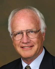
Larry P. Atkinson[/caption]
The OOI Team notes with great sadness the passing of Dr. Larry Atkinson on December 22nd, 2020. Larry was Eminent Scholar Emeritus and Professor Emeritus of Ocean, Earth and Atmospheric Sciences in the Department of Ocean, Earth and Atmospheric Sciences and the Center for Coastal Physical Oceanography at Old Dominion University. In addition to significant contributions to oceanographic research and education throughout a distinguished career at a number of institutions, Larry served for many years as Chair and then Past Chair of the OOI Facilities Board (OOIFB), which provides independent input and guidance regarding the management and operation of the OOI to the National Science Foundation.
Throughout his many years of service on the OOIFB, Larry provided valuable advice and consistent encouragement as the program was being implemented and developed. In 2020, in recognition of his many contributions, the OOIFB established the Larry P. Atkinson Travel Fellowship for Students and Early Career Scientists, which will enable students and scientists from across the globe to meet and advance the understanding of the ocean. Larry will be greatly missed by those members of the OOI Team who worked closely with him, and by the many more who were influenced and impacted by his steadfast wisdom and support.
Larry’s obituary can be read here.
Read MoreOcean Visions: New RCA Video Tells Grand Visual Story
Ocean Visions – The story of the Regional Cabled Array
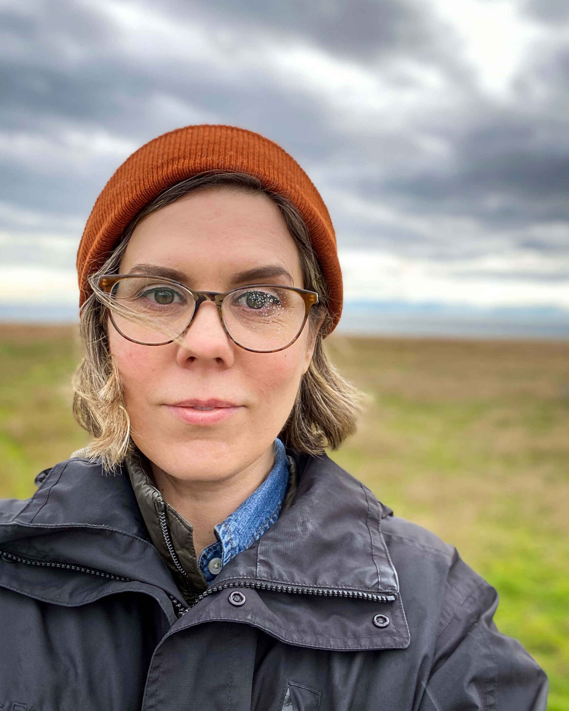
Sarah Smith is not your typical undergraduate. She is a 41-year-old communications major at the University of Washington (UW) Tacoma, who used her life experience and creative talent to produce a nine-minute video Ocean Visions that tells the story of the Ocean Observatories Initiative Regional Cabled Array. The production is stunning and Smith achieved her goal of showing the human side of science. Smith served as writer, producer, and director of the production.
“I wanted to show the human side of science…that people come up with big ideas like the Regional Cabled Array. And, these big ideas that take years to come to fruition and so much money to realize, “ Smith explained. “I also wanted to convey that there are these dedicated people out there working hard at what they are passionate about, continually asking questions. While people might romanticize ocean research, it’s really hard work. It’s dangerous and conditions can be wild. I wanted viewers to see and understand all that it takes to make these big ideas happen.”
Smith’s former work as a photographer and visual artist is apparent in this nine-minute video, about the Regional Cabled Array, which provides electricity and Internet to >150 instruments measuring ocean and Earth conditions. Working initially with UW oceanography professor Cheryl Greengrove, Smith had hoped to be aboard the R/V Thomas G. Thompson this past summer with the scientific team as part of their educational VISIONS program. COVID-19 put an end to those plans. Instead, she spent hours and hours going through footage in RCA’s considerable archive of video and images of life below the surface, Interactive Oceans. (She’s hoping that the stars will align and a trip aboard the R/V Revelle will be possible next summer during RCA’s regular operations and maintenance cruise.)
“It’s hard to estimate how many hours I spent on the project. Sometimes it felt like I was living and breathing the project, but it was an incredible experience for which I am grateful,” she said. Smith did everything from schlepping the camera equipment, making sure the lighting was right, asking the questions, and spending hours in the editing room to ensure the story of the RCA was accurate and compelling.
Smith will graduate next month with a major in communications. She has an internship lined up after that with NASA where she will be working with its STEM program connecting students with the International Space Station. From there, she plans on heading to graduate school in a cinema and media studies program. “I just want to keep exploring. Video and film are such important communication tools, which are constantly evolving. I want to be part of that changing story to continue to tell stories of people who doggedly follow their curiosity as did those involved in making the RCA a reality.”
Read More
Recordings of OOI Events at AGU
Just in case you missed some of the events at OOI’s virtual booth at AGU, we’ve compiled some recordings and information so you can watch as your schedule allows:
[embed]http://https://youtu.be/Wuc-Be-IFVA[/embed] [embed]https://www.youtube.com/watch?v=WuEXjlXl-HM&t=5s[/embed] [embed]https://www.youtube.com/watch?v=bWqvOzyYirE[/embed]How Scientists are Using OOI Data to Advance Their Research
Learn How to Create a Data View
[embed]https://youtu.be/uRd0Js9L0-I[/embed]Virtual Tours
[embed]https://www.youtube.com/watch?v=3w3RyvUGeLA[/embed] [embed]https://www.youtube.com/watch?v=GqJdkqI-unw&t=19s[/embed] [embed]https://youtu.be/epkV9K6_w4U[/embed] Read MoreJoin in the Conversation: New Forum Live!

[media-caption path="/wp-content/uploads/2020/11/Discourse_logo.png" link="#"]Source: Discourse Team[/media-caption]
The Ocean Observatories Initiative would like to hear from all data users and potential data users. To that end, we have launched a platform on Discourse to encourage “discourse.” The OOI Data Users Discussion Forum is a place where scientists, educators, and other data users can come together to ask and have questions answered and share how OOI data are being used to advance research and learning.
Some of the topics covered are
- data tools (where you can learn new techniques for using data)
- known data and system issues and updates on their status
- potential funding and job opportunities
- FAQS that will help you navigate and use OOI data
- HelpDesk, where you can seek help and learn about other help requests that may shed light on your question
- news and announcements that are relevant to using OOI data in research and in the classroom.
Since it is a user-based forum, you can add categories and questions of interest to you.
Sign on today or bookmark this url https://discourse.oceanobservatories.org/ for future engagement. Once you sign up, you will receive an email confirming you are not a bot, then the conversation can begin.
We are looking forward to some lively discussions! See you online.
Read More
OOI’s AGU Virtual Booth and Sessions Schedule 2020
OOI’s Virtual Booth
The Ocean Observatories Initiative has a full plate of activities at its virtual AGU booth during AGU’s exhibit hall hours. Registration is required for the 11 am-noon time slots, indicated below.
Friday 11 December
- 11 am-noon Eastern: Learn how to create data views using the new Date Explorer: Register here.
OOI Data Team and Coastal Endurance team member Craig Risien will guide us through the steps of creating a data view using Coastal Endurance array data to demonstrate this feature of OOI’s new data discovery tool, Data Explorer.
- 1-1:30 pm Eastern: Ask an expert about what scientists are learning using OOI data. Join here.
Join William Wilcock, University of Washington, and Hilary Palevsky, Boston College, to hear what they have learned using OOI data and how you might do the same.
- 6-7 pm Eastern: Early Career Scientists’ Happy Hour. Join here.
Close down the OOI virtual booth by joining your friends and colleagues at a virtual hour. This is an opportunity to network, reconnect with friends and colleagues, and raise a glass together.
All activities other than the 11 am time slots and Friday’s happy hour can be accessed here. Look forward to seeing you soon!
___________________________________________________________________________________________
OOI-Related Sessions
Friday, 11 December 2020
07:00 – 23:59
Posters
B060-0022 Western boundary current instability gives rise to extraordinary subsurface diatom blooms in the Middle Atlantic Bight slope sea
Hilde Oliver1, Weifeng Gordon Zhang1, Walker O Smith Jr2, Philip Alatalo3, Dreux Chappell4, Andrew Hirzel1, Gwyneth Packard5, Corday Selden6, Judson Poole1, Heidi M Sosik1, Rachel Stanley7, Yifan Zhu4 and Dennis Joseph McGillicuddy Jr8, (1)Woods Hole Oceanographic Institution, Woods Hole, MA, United States, (2)Virginia Inst Marine Sciences, Gloucester Point, VA, United States, (3)Woods Hole Oceaonographic Institution, Woods Hole, MA, United States, (4)Old Dominion University, Ocean, Earth and Atmospheric Sciences, Norfolk, VA, United States, (5)Woods Hole Oceanographic Institution, Woods Hole, United States, (6)Cuernavaca, Mexico, (7)Wellesley College, Wellesley, MA, United States, (8)Woods Hole Oeanographic Institution, Woods Hole, MA, United States
Monday, 14 December 2020
07:00 – 23:59
Posters
OS037-0009 Sustained Ocean Observatories Initiative Glider Measurements Over the Oregon and Washington Shelves
Stuart Pearce, Oregon State University, College of Earth, Ocean, and Atmospheric Sciences, Corvallis, OR, United States, Jonathan Whitefield, Oregon State University, College of Earth Ocean and Atmospheric Sciences, Corvallis, OR, United States and Edward Paul Dever, Oregon State University, Corvallis, OR, United States
A151-0011 On the Impact of High-Frequency Wind Variability on Upper Ocean Stratification
Natalie M Freeman, University of Colorado at Boulder, Department of Atmospheric and Oceanic Sciences, Boulder, CO, United States, Donata Giglio, University of Colorado Boulder, Department of Atmospheric and Oceanic Sciences, Boulder, CO, United States, Sarah T Gille, UCSD, La Jolla, CA, United States and Momme Claus Hell, University of California San Diego, Scripps Institution of Oceanography, La Jolla, CA, United States
ED037-0031 What drives variability in nitrate concentration off the Oregon Coast?
Bailey Armos, University of Washington, Oceanography, Seattle, WA, United States and Edward Paul Dever, Oregon State University, Corvallis, OR, United States
ED037-0035 Ocean pCO2 Variability and Drivers at the US Atlantic Coastal Pioneer Array
Alison Thorson, Sarah Lawrence College, Bronxville, NY, United States and Rachel Eveleth, Oberlin College, Oberlin, United States
OS036-0005 Dissolved Oxygen Over The Oregon And Washington Shelves Observed From Sustained Glider, Profiler, And Fixed Depth Time Series
Edward Paul Dever1, Jonathan P Fram2, Michael Vardaro3,4, Wendi Ruef5, Orest Eduard Kawka5, Jack A Barth6, Craig M Risien2, Christopher E Wingard2, Stuart Pearce2 and Jonathan Whitefield1, (1)Oregon State University, Corvallis, OR, United States, (2)Oregon State University, College of Earth, Ocean, and Atmospheric Sciences, Corvallis, OR, United States, (3)Rutgers University, Department of Marine and Coastal Sciences, NJ, United States, (4)University of Washington Seattle Campus, Oceanography, Seattle, WA, United States, (5)University of Washington, School of Oceanography, Seattle, WA, United States, (6)Oregon State University, Marine Studies Initiative, Corvallis, OR, United States
ED037-0044 Vertical Zooplankton Distribution on Continental Slope off Oregon Coast
Lydia Sgouros, Case Western Reserve University, Cleveland, OH, United States and Edward Paul Dever, Oregon State University, Corvallis, OR, United States
Wednesday 16, December 2020
07:00 – 23:59
Posters
V040-0016 Monitoring Hydrothermal Plumes at ASHES Vent Field, Axial Seamount through Quantitative Acoustic Imaging
Guangyu Xu, Applied Physics Laboratory University of Washington, Acoustics, Seattle, WA, United States, Karen G Bemis, Rutgers, The State University of New Jersey – New Brunswick, Marine and Coastal Sciences, New Brunswick, NJ, United States, Darrell Jackson, University of Washington Seattle Campus, Applied Physics Laboratory, Seattle, WA, United States and Anatoliy N. Ivakin, Applied Physics Laboratory University of Washington, Seattle, WA, United States
14:50 – 14:54
Virtual Talk
V043-06 Repeated Short-Term Deflation Events Observed During Long-Term Inflation at Axial Seamount
William W. Chadwick Jr1, Scott L Nooner2, William S D Wilcock3, Suzanne M Carbotte4, Audra Meaghan Sawyer5, Erik K Fredrickson3 and Jeff W Beeson1, (1)Oregon State University, CIMRS, Newport, OR, United States, (2)University of North Carolina at Wilmington, Dept of Earth and Ocean Sciences, Wilmington, NC, United States, (3)University of Washington, School of Oceanography, Seattle, WA, United States, (4)Lamont-Doherty Earth Obs, Palisades, NY, United States, (5)University of North Carolina at Wilmington, Wilmington, NC, United States
Read More
OOI at AGU 2020
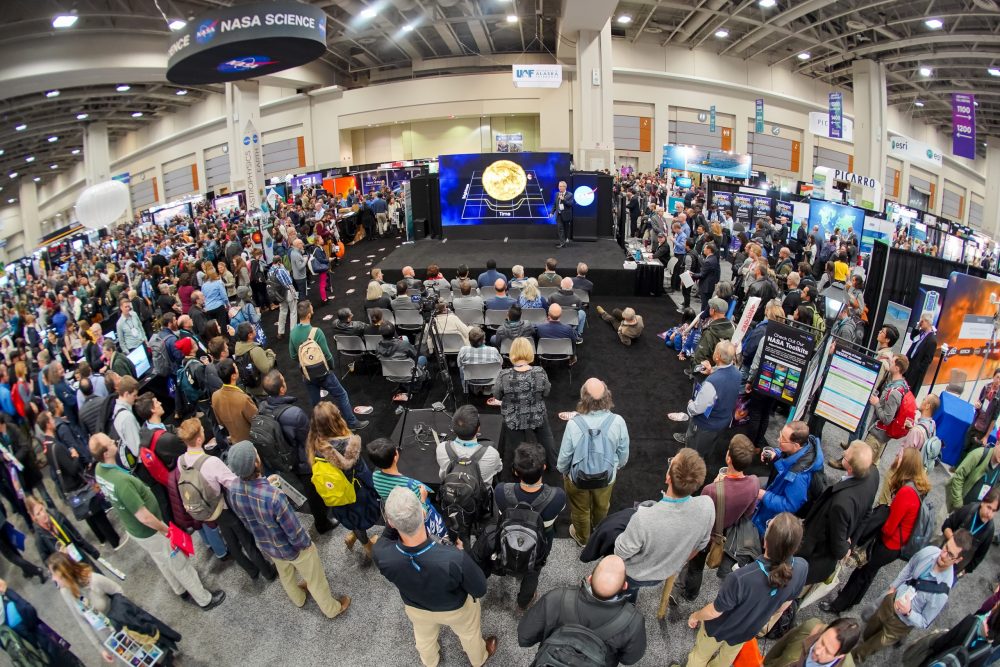
[media-caption path="/wp-content/uploads/2020/10/agufront2-scaled-e1603490292321.jpeg" link="#"]The AGU 2020 Fall Meeting will not be like the 2019 pictured here, but OOI will still have a large presence. [/media-caption]
OOI will be a force at the first online AGU Fall meeting. Join your colleagues as they present their latest scientific findings made possible using OOI data. OOI will also be hosting a virtual booth at AGU this year. Like the meeting of the past, it will provide a place to gather, share experiences, and learn more about OOI.
We have a robust schedule of activities at the OOI exhibit booth (each day at 11 am, 1 pm, and 6 pm) during the week of 7 December. Have a look here. Pre-registration is needed for the 11 am time slots, but all others are accessible with a click of a link. Hope to see you there!
If we’ve missed any OOI-related sessions, please contact dtrewcrist@whoi.edu and we will be happy to add them. Otherwise, see you all online. Hope you will share your stories at #AGU20OOI.
Monday, 7 December 2020
07:00 – 23:59
Posters
ED004-0045 Magnitude and Drivers of the Seasonal Cycle and Interannual Variability of pCO2 in the Washington Coast OOI Endurance Array
Brianna Velasco, Humboldt State University, Arcata, CA, United States, Rachel Eveleth, Oberlin College, Oberlin, United States and Alison Thorson, Sarah Lawrence College, Bronxville, NY, United States
Tuesday, 8 December 2020
10:00-11:00
Ocean Observatories Initiative Facility Board Town Hall
Wednesday, 9 December 2020
19:42 – 19:45
Virtual Talk
V018-14 Submarine Volcano-Hydrothermal Systems and Their Impacts on the Overlying Ocean: Quantification of Erupting Mid-Ocean Ridge Volcanoes- A Generational Goal
John R Delaney1, Dana Manalang2, Kendra L Daly3, Deborah S Kelley4, William S D Wilcock1, Edward T Baker5 and Douglas S Luther6, (1)University of Washington, School of Oceanography, Seattle, WA, United States, (2)University of Washington, Applied Physics Lab, Seattle, WA, United States, (3)University of South Florida, College of Marine Science, St. Petersburg, FL, United States, (4)University of Washington Seattle Campus, School of Oceanography, Seattle, WA, United States, (5)NOAA Pacific Marine Environmental Laboratory, Seattle, WA, United States, (6)Univ Hawaii Manoa, Honolulu, HI, United States
Friday, 11 December 2020
07:00 – 23:59
Posters
B060-0022 Western boundary current instability gives rise to extraordinary subsurface diatom blooms in the Middle Atlantic Bight slope sea
Hilde Oliver1, Weifeng Gordon Zhang1, Walker O Smith Jr2, Philip Alatalo3, Dreux Chappell4, Andrew Hirzel1, Gwyneth Packard5, Corday Selden6, Judson Poole1, Heidi M Sosik1, Rachel Stanley7, Yifan Zhu4 and Dennis Joseph McGillicuddy Jr8, (1)Woods Hole Oceanographic Institution, Woods Hole, MA, United States, (2)Virginia Inst Marine Sciences, Gloucester Point, VA, United States, (3)Woods Hole Oceaonographic Institution, Woods Hole, MA, United States, (4)Old Dominion University, Ocean, Earth and Atmospheric Sciences, Norfolk, VA, United States, (5)Woods Hole Oceanographic Institution, Woods Hole, United States, (6)Cuernavaca, Mexico, (7)Wellesley College, Wellesley, MA, United States, (8)Woods Hole Oeanographic Institution, Woods Hole, MA, United States
Monday, 14 December 2020
07:00 – 23:59
Posters
OS037-0009 Sustained Ocean Observatories Initiative Glider Measurements Over the Oregon and Washington Shelves
Stuart Pearce, Oregon State University, College of Earth, Ocean, and Atmospheric Sciences, Corvallis, OR, United States, Jonathan Whitefield, Oregon State University, College of Earth Ocean and Atmospheric Sciences, Corvallis, OR, United States and Edward Paul Dever, Oregon State University, Corvallis, OR, United States
A151-0011 On the Impact of High-Frequency Wind Variability on Upper Ocean Stratification
Natalie M Freeman, University of Colorado at Boulder, Department of Atmospheric and Oceanic Sciences, Boulder, CO, United States, Donata Giglio, University of Colorado Boulder, Department of Atmospheric and Oceanic Sciences, Boulder, CO, United States, Sarah T Gille, UCSD, La Jolla, CA, United States and Momme Claus Hell, University of California San Diego, Scripps Institution of Oceanography, La Jolla, CA, United States
ED037-0031 What drives variability in nitrate concentration off the Oregon Coast?
Bailey Armos, University of Washington, Oceanography, Seattle, WA, United States and Edward Paul Dever, Oregon State University, Corvallis, OR, United States
ED037-0035 Ocean pCO2 Variability and Drivers at the US Atlantic Coastal Pioneer Array
Alison Thorson, Sarah Lawrence College, Bronxville, NY, United States and Rachel Eveleth, Oberlin College, Oberlin, United States
OS036-0005 Dissolved Oxygen Over The Oregon And Washington Shelves Observed From Sustained Glider, Profiler, And Fixed Depth Time Series
Edward Paul Dever1, Jonathan P Fram2, Michael Vardaro3,4, Wendi Ruef5, Orest Eduard Kawka5, Jack A Barth6, Craig M Risien2, Christopher E Wingard2, Stuart Pearce2 and Jonathan Whitefield1, (1)Oregon State University, Corvallis, OR, United States, (2)Oregon State University, College of Earth, Ocean, and Atmospheric Sciences, Corvallis, OR, United States, (3)Rutgers University, Department of Marine and Coastal Sciences, NJ, United States, (4)University of Washington Seattle Campus, Oceanography, Seattle, WA, United States, (5)University of Washington, School of Oceanography, Seattle, WA, United States, (6)Oregon State University, Marine Studies Initiative, Corvallis, OR, United States
ED037-0044 Vertical Zooplankton Distribution on Continental Slope off Oregon Coast
Lydia Sgouros, Case Western Reserve University, Cleveland, OH, United States and Edward Paul Dever, Oregon State University, Corvallis, OR, United States
Wednesday 16, December 2020
07:00 – 23:59
Posters
V040-0016 Monitoring Hydrothermal Plumes at ASHES Vent Field, Axial Seamount through Quantitative Acoustic Imaging
Guangyu Xu, Applied Physics Laboratory University of Washington, Acoustics, Seattle, WA, United States, Karen G Bemis, Rutgers, The State University of New Jersey – New Brunswick, Marine and Coastal Sciences, New Brunswick, NJ, United States, Darrell Jackson, University of Washington Seattle Campus, Applied Physics Laboratory, Seattle, WA, United States and Anatoliy N. Ivakin, Applied Physics Laboratory University of Washington, Seattle, WA, United States
14:50 – 14:54
Virtual Talk
V043-06 Repeated Short-Term Deflation Events Observed During Long-Term Inflation at Axial Seamount
William W. Chadwick Jr1, Scott L Nooner2, William S D Wilcock3, Suzanne M Carbotte4, Audra Meaghan Sawyer5, Erik K Fredrickson3 and Jeff W Beeson1, (1)Oregon State University, CIMRS, Newport, OR, United States, (2)University of North Carolina at Wilmington, Dept of Earth and Ocean Sciences, Wilmington, NC, United States, (3)University of Washington, School of Oceanography, Seattle, WA, United States, (4)Lamont-Doherty Earth Obs, Palisades, NY, United States, (5)University of North Carolina at Wilmington, Wilmington, NC, United States
Read More
Potential Relocation of the OOI Pioneer Array Discussion 8 Dec
The National Science Foundation (NSF) will present plans to use an “Ideas Lab”, a participatory, immersive process designed to innovative the decision-making process for the potential move of the Ocean Observatories Initiative (OOI) Pioneer Array at the American Geophysical Union Fall Meeting. The presentation will be at the OOI virtual booth, on 8 December 11:15-noon Eastern. Lisa Clough, Section Head from NSF’s Division of Ocean Sciences, will describe the “Ideas Lab” process that will be used to determine if the Pioneer Array should be moved, and if so, to what location. She will be joined by Al Plueddemann, Project Scientist for OOI’s Coastal and Global Scale Nodes, who will speak to the operational considerations involved in a potential move of the Pioneer Array.
The Coastal Pioneer Array is currently located in the Middle Atlantic Bight, centered about 75 nautical miles south of Martha’s Vineyard, where the continental shelf-slope is highly productive. The area was chosen as the initial placement of the Pioneer Array to examine exchanges between the shelf and slope and the shelf ecosystem and provide insight into air-sea gas exchange, including carbon dioxide absorption. From the outset, NSF has committed to re-evaluating the placement of the Pioneer Array every five-to-seven years.
“Ideas Lab are designed to bring together people to innovate and invigorate their scientific and educational approaches. We hope by using this participatory process, current and future users of OOI data will deeply explore the opportunities of having an open-data real-time coastal ocean array in various locations within the US EEZ,” explained Clough. “It is our hope that by collectively considering what the optimal location for the Pioneer Array is, and to a certain extent what types of data will be collected and how, the decision-making process will also encourage new thinking.”
Plueddemann, who has been involved with 15 successful missions to recover and deploy equipment at the Pioneer Array, will introduce some of the technological, logistical and environmental considerations inherent in a decision to relocate the array.
“My role in this decision-making process is solely as an information broker,” explained Plueddemann. “Neither I nor anyone involved in the current Pioneer Array team will be involved in the process of deciding how and where the Pioneer Array might be relocated. Our role will be to inform and advise on the feasibility of different concepts.”
Regardless of the location decision, the current team at Woods Hole Oceanographic Institution will continue to operate the Pioneer Array. Their formal role as operators of the Array entails expertise in the deployment, recovery, and maintenance of the equipment.
REGISTER NOW!
Potential Relocation of the Pioneer Array: Participate in the Process
8 December from 11:15 am-noon
Read More
OOI Links Up with U.S. National Committee for the Ocean Decade
[media-caption path="/wp-content/uploads/2020/11/ODUS-Announcements-02-OS.jpg" link="#"]Ocean Decade U.S. is seeking innovative, potentially transformational, ideas about ocean science research. Honor your creativity and submit an “Ocean Shot.” Deadline is 1 December.[/media-caption]
The Ocean Observatories Initiative (OOI) has signed on as partner with the UN Decade of Ocean Science for Sustainable Development, which is geared toward scientists, policy makers, managers, and service users working together to ensure that ocean science delivers greater benefits for the ocean ecosystem and for society. OOI is part of the Ocean Decade’s Ocean Science and Technology community, making its ocean data available to the world community.
To help advance the United States involvement in the UN Decade program, OOI has also joined forces as a nexus organization with the U.S. National Committee for the Ocean Decade (Ocean Decade U.S.). The goal is to ensure that the U.S. ocean science community is aware of and participating in activities related to the UN Decade of Ocean Science.
“OOI offers a wealth of ocean data that is being used to advance understanding of ocean processes,” said John Trowbridge, lead of OOI’s program office at Woods Hole Oceanographic Institution. “We think it is important to offer this valuable resource up to the world community, and by so doing, contribute to the advancement of a sustainable ocean that benefits all users.”
Two opportunities currently exist for members of the OOI community to get involved:
Share your transformative research ideas
The Ocean Decade U.S. is seeking transformative research ideas known as “Ocean-Shots,” that draw inspiration and expertise from multiple disciplines and fundamentally advance ocean science for sustainable development. The hope is that such innovative ideas will spark potentially disruptive advances in ocean science for sustainable development. Applications are due before December 1, 2020, so the time is now to gather your colleagues together and consider proposing some innovative research ideas. To learn more, click here or if you already have a great innovative idea, use a simple online form to submit your winning idea. Submitted “Ocean Shots” will be presented at the Ocean Decade U.S. Kickoff meeting, January 13-14, 2021.
Early Career Scientist Candidates Sought
Knowing that the fate of the global ocean rests with future generations, the US National Committee for the Ocean Decade is also seeking to include early career perspectives in the activities of the Committee. Early career natural scientists, social scientists, engineers, resource managers, and policy specialists are encouraged to apply as liaisons to the Committee. Again, the application deadline is December 1, 2020. If you are looking to have a voice in what the ocean may look like in the future and how it is used, consider applying today.
Adds Trowbridge, “There is no better time than now to consider the future ocean and how it might can be sustainably used now so its many wonders and resources will be available to future generations.”
Read More
Rolling Seas, Followed by Blue Skies During Pioneer 15
The weather for the 15-day Pioneer 15 expedition aboard the R/V Neil Armstrong came in like a lion and left like a lamb. As the ship departed the Woods Hole dock on 28 October, the sky was gray, the air damp, and the forecast foreboding as the 10- member scientific team and the crew of the R/V Neil Armstrong headed toward the Pioneer Array, about 75 nautical miles south of Martha’s Vineyard.
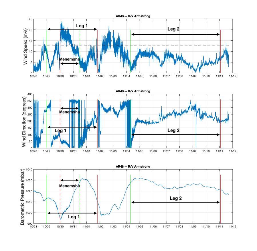
During Leg 1, the ship had some rocky days and briefly sought the protection of Menemsha Bight on the northwest side of Martha’s Vineyard as Tropical Storm Zeta passed through and brought her fury with her. Leg 2 of the journey brought with it clear skies and smooth sailing. The following shows the wind and pressure data from the ship throughout the Pioneer 15 cruise.
[media-caption path="/wp-content/uploads/2020/11/AR48_Weather-1_annotated.jpg" link="#"]Wind speed, direction, and barometric pressure from the met mast of the R/V Neil Armstrong. The green lines indicate when the ship arrived at the Array, the red lines show when it departed. The solid lines are for Leg 1 and Leg 2, and the dashed lines are the excursion to Menemsha in Leg 1. Credit: Sheri N. White (WHOI)[/media-caption]
Chief Scientist Sheri N. White said, “Despite the difficult weather, we had a very successful mission. The team recovered and deployed three coastal surface moorings and a profiler mooring, and deployed two winter coastal profiler moorings. We also were able to recover three gliders, and collect shipboard and CTD data in the vicinity of the Array. We planned on a bit of flexibility in the schedule due to the late fall departure, which always brings with it unpredictable conditions.”
The expedition was conducted in two legs because all of the moorings could not be accommodated on the ship at the same time. The Team returned to home port at the conclusion of the cruise on 11 November, when they disembarked after a month of being either in isolation or at sea away from friends and family.
The recovered moorings are now undergoing refurbishment onsite at WHOI so they will be ready for the next equipment turn in spring 2021. Next on tap for the Pioneer Array is the deployment of four gliders, Next on tap for the Pioneer Array is the deployment of four gliders, which will be done from a small vessel when the weather allows a safe transit.
Pioneer 15 in Pictures
[media-caption path="/wp-content/uploads/2020/11/DSC_0138-scaled.jpg" link="#"]The Pioneer 15 Team deploys the Central Surface Mooring on Leg 1 in dreary weather. Credit: Dee Emrich©WHOI[/media-caption]
[media-caption path="/wp-content/uploads/2020/11/DSC_0685-scaled.jpg" link="#"]The Pioneer 15 Team recovers the Inshore Surface Mooring. It had been in deployed in the water for 12 months. Credit: Dee Emrich©WHOI[/media-caption]
[media-caption path="/wp-content/uploads/2020/11/IMG_4234-scaled.jpg" link="#"]The Team dressed as oceanographers for Halloween… and deployed the Inshore Profiler Mooring in the few hours of clear skies between two storms at the Pioneer Array. Credit: Sheri N. White©WHOI[/media-caption]
[media-caption path="/wp-content/uploads/2020/11/IMG_4244-scaled.jpg" link="#"]The R/V Neil Armstrong left the WHOI dock on Leg 2 of the Pioneer 15 expedition, with the Central Surface Mooring in position for deployment. Credit: Sheri N. White©WHOI[/media-caption]
[media-caption path="/wp-content/uploads/2020/11/IMG_4245-scaled.jpg" link="#"]The Offshore Surface Mooring is ready for deployment on the stern of the R/V Neil Armstrong on Leg 2. Credit: Dee Emrich©WHOI[/media-caption]
[media-caption path="/wp-content/uploads/2020/11/IMG_4245-scaled.jpg" link="#"]Beautiful weather on Leg 2 made recovering the large surface moorings a bit easier. The surface moorings were deployed for 12 months, rather than six, due to the COVID pandemic. Credit: Jennifer Batryn©WHOI[/media-caption]
[media-caption path="/wp-content/uploads/2020/11/PMOU-16_deploy.jpg" link="#"]This is what a Profiler Mooring looks like during deployment. Profiler Moorings collect data from the entire water column using a McLane Moored Profiler, which crawls up and down the mooring line. Credit: Sheri N. White©WHOI[/media-caption]
[media-caption path="/wp-content/uploads/2020/11/ISSM_Biofouling.jpg" link="#"]This is some of the biology that has taken up residence on the Inshore Surface Mooring during its year-long stay on the Atlantic continental shelf. Credit: Dee Emrich©WHOI[/media-caption]
Read More
OOIFB Town Hall 8 Dec, Includes Lightning Talks
The Ocean Observatories Initiative Facilities Board (OOIFB) will host a Town Hall during the virtual 2020 Fall AGU meeting. The Town Hall is scheduled for Tuesday, December 8th from 10:00 am to 11:00 am EST. The community will have the opportunity to hear the latest information about the OOI facility, meet the OOIFB members, and learn about research using OOI data. The new OOI Data Explorer tool will be demonstrated, the exciting activities of OOI education programs will be featured, and early career scientist activities will be highlighted.
The Town Hall is aimed at researchers who are now using or are considering using OOI data, researchers interested in adding instrumentation to the OOI infrastructure, and educators at all levels interested in the OOI. Lightning talks will be presented during the Town Hall, as well as at OOI’s virtual booth on Thursday 10 December from 6-7 pm. For those interested in the Thursday presentation, join the discussion here.
Event: OOI Facility Board Town Hall
When: Tuesday, December 8th from 10:00 am to 11:00 am EST (7:00 am to 8:00 am Pacific)
Additional Details: https://ooifb.org/meetings/2020-agu-meeting-ooifb-town-hall/
Town Hall Agenda
1000 Welcome, Introductions, Activity Update – Kendra Daly (USF), OOIFB Chair
1005 Updates from the National Science Foundation – Lisa Clough (NSF)
1015 Updates from the OOI Operator – John Trowbridge (WHOI)
1020 OOI Date Explorer Demo – Brian Stone (Axiom)
1025 OOI Education Data Labs Report – Janice McDonnell (Rutgers U)
1030 OOI Activities initiatives by Early Career Scientists – Sophie Clayton (ODU)
1035 Lightning Talk Presentations
1055 Questions, Answers, and Discussion
1100 End of Town Hall
Lightning Talk Presenters
Shima Abadi, University of Washington
Bill Chadwick Oregon State University
Bill Davis, BeachNecessities.com
Rachel Eveleth, Oberlin College
Erik Fredrickson, University of Washington, School of Oceanography
Natalie Freeman, University of Colorado Boulder
Matthew Lobo, Portland State University
Aaron Mau, University of South Carolina
Chris Russoniello, West Virginia University
William Wilcock, University of Washington
Guangyu Xu, Applied Physics Laboratory, University of Washington
Read More