
OOI In The News
Striped Bass Link OOI Pioneer Array Locations
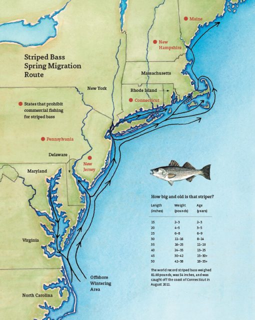
A recent article in the Martha’s Vineyard Gazette tells a fascinating tale of how fish like striped bass respond to changes in ocean conditions. The striped bass story also provides links between the current OOI Pioneer Array location on the New England Shelf (NES) and the new location in the southern Mid-Atlantic Bight (MAB).
The Northwest Atlantic has been warming due to both atmospheric and oceanographic influences (e.g., Chen et al., 2014; Gawarkiewicz et al., 2019) and the impacts can bee seen in the distribution of marine species like stripers. The stripers are typically found on the New England Shelf in the spring, with bass fishing tournaments a long-held tradition for islands like Martha’s Vineyard, Nantucket, and Cuttyhunk. But conditions are changing, and as the waters warm, the stripers appear to be moving further north. Data from the NES Pioneer Array are helping researchers and fishers understand the changes.
[media-caption path="/wp-content/uploads/2022/05/Striped-Bass-migration-map.jpg" link="#"]Striped bass spring migration route. Credit: Martha’s Vineyard Gazette and Dana Gaines Martha’s Vineyard Magazine.[/media-caption]
Stripers spawn in brackish water and spend their first few years in estuarine waters like those of the Chesapeake Bay. These waters are changing too, with earlier springs modifying spawning behavior. Understanding how environmental conditions impact the life cycle of stripers from estuary to open ocean requires knowledge of the atmosphere, continental shelf waters, and the Gulf Stream. Finally, it is necessary to investigate interactions that exchange properties between estuaries, shelf and slope sea – which will be the focus of the MAB Pioneer Array currently being planned for implementation in 2024.
References
Chen, K., G. G. Gawarkiewicz, S. J. Lentz, and J. M. Bane (2014), Diagnosing the warming of the Northeastern U.S. Coastal Ocean in 2012: A linkage between the atmospheric jet stream variability and ocean response, J. Geophys. Res. Oceans, 119, doi:10.1002/2013JC009393.
Gawarkiewicz G, Chen K, Forsyth J, Bahr F, Mercer AM, Ellertson A, Fratantoni P, Seim H, Haines S and Han L (2019), Characteristics of an Advective Marine Heatwave in the Middle Atlantic Bight in Early 2017. Front. Mar. Sci. 6:712. doi: 10.3389/fmars.2019.00712.
Schneider, P. (2022), Climate Change Clue: Follow the Stripers. Vineyard Gazette, 12 May 2022.
Read MoreOOI’s Tools Could Be Leveraged to Support Blue Economy
In an opinion piece published on March 2, 2022 in The Hill, Woods Hole Oceanographic Institutions’s President and Director Peter de Menocal and Scripps Institution of Oceanography’s Director and Vice Chancellor for Marine Sciences and Dean of the School of Marine Sciences at the University of California San Diego Margaret Leinen laud OOI and Argo’s contributions to learning about the ocean:
The full text of the opinion piece can be accessed here:
IPCC’s words matter — and so does the ocean
Fishers and OOI Scientists Working Together to Advance Science

An article in the Cape Cod Commercial Fishermen’s Alliance newsletter highlighted the work between its members and scientists at Woods Hole Oceanographic Institution (WHOI), using OOI Pioneer Array data. The collaboration resulted in discovery of …“ all these things happening on the New England Shelf that we didn’t anticipate,” said Al Plueddemann, a senior scientist in physical oceanography at WHOI.
An important change in recent years is an increase in the meandering or “wiggliness” of the Gulf Stream. In addition the Gulf Stream has been generating more “Warm Core Rings,” large clockwise eddies.
Read more about how the collaboration is advancing science here.
OOI’s Contributions to Understanding the Changing Ocean Cited in Boston Globe
Woods Hole Oceanographic Institution Research Scientist Glen Gawarkiewicz cites how he uses OOI data to figure out what is happening in the changing ocean in an article on that appeared on the front page of the Boston Globe on December 28, 2021.
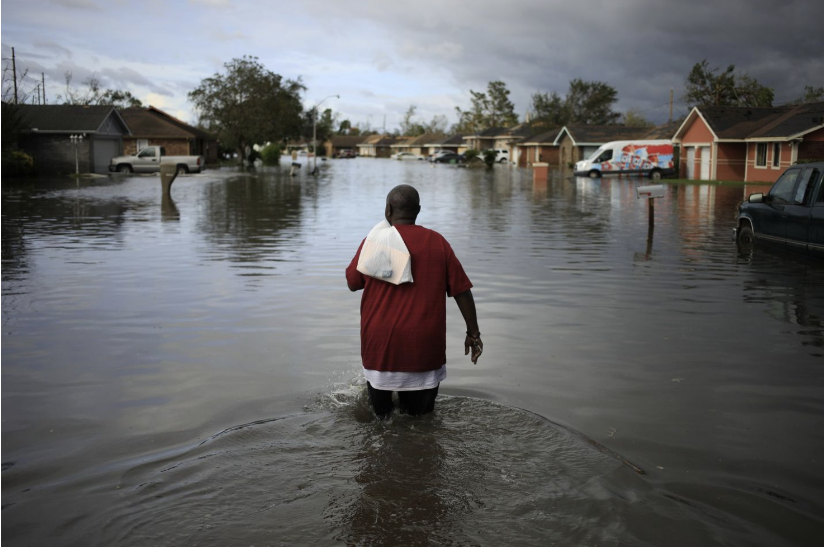
In a record-breaking year of weather, signs of a changed world.
[caption id="attachment_22801" align="alignnone" width="1610"] A resident walked through floodwaters left by Hurricane Ida in La Place Louisiana on August 30, 2921. Credit: Luke Sharrett/Bloomberg via the Boston Globe.[/caption]
Read More Ocean Data Lab Nuggets Providing Foundation for Accessible Oceans
Oregon Sea Grant Spotlights Partner OOI
In its August 2021 newsletter, Oregon Sea Grant highlights the work of OOI’s Endurance Array Team at Oregon State University. Sea Grant Scholar Charlotte Klein interviewed the Endurance Array Principal Investigator Ed Dever, who describes some of challenges in keeping arrays operational in a challenging offshore environment.
The article can be found here, on page four.
Read MorePioneer Data Sheds Light on Massive Plankton Blooms
“The big mystery about plankton is what controls its distribution and abundance, and what conditions lead to big plankton blooms,” said Dennis McGillicuddy, Senior Scientist and Department Chair in Applied Ocean Physics and Engineering at the Woods Hole Oceanographic Institution (WHOI).
Two new papers explore this question and provide examples of conditions that lead to massive plankton blooms with vastly different potential impacts on the ecosystem, according to McGillicuddy, co-author of both papers. Both papers also point to importance of using advanced technology—including video plankton recorders, autonomous underwater vehicles, and the Ocean Observatories Initiative’s Coastal Pioneer Array—to find and monitor these blooms.
In one paper, Diatom Hotspots Driven by Western Boundary Current Instability, published in Geophysical Research Letters (GRL), scientists found unexpectedly productive subsurface hotspot blooms of diatom phytoplankton.
In the GRL paper, researchers investigated the dynamics controlling primary productivity in a region of the Mid-Atlantic Bight (MAB), one of the world’s most productive marine ecosystems. In 2019, they observed unexpected diatom hotspots in the slope region of the bight’s euphotic zone, the ocean layer that receives enough light for photosynthesis to occur. Phytoplankton are photosynthetic microorganisms that are the foundation of the aquatic food web.
It was surprising to the researchers that the hotspots occurred in high-salinity water intruding from the Gulf Stream. “While these intrusions of low‐nutrient Gulf Stream water have been thought to potentially diminish biological productivity, we present evidence of an unexpectedly productive subsurface diatom bloom resulting from the direct intrusion of a Gulf Stream meander towards the continental shelf,” the authors note. They hypothesize that the hotspots were not fueled by Gulf Stream surface water, which is typically low in nutrients and chlorophyll, but rather that the hotspots were fueled by nutrients upwelled into the sunlight zone from deeper Gulf Stream water.
With changing stability of the Gulf Stream, intrusions from the Gulf Stream had become more frequent in recent decades, according to the researchers. “These results suggest that changing large‐scale circulation has consequences for regional productivity that are not detectable by satellites by virtue of their occurrence well below the surface,” the authors note.
“In this particular case, changing climate has led to an increase in productivity in this particular region, by virtue of a subtle and somewhat unexpected interaction between the physics and biology of the ocean. That same dynamic may not necessarily hold elsewhere in the ocean, and it’s quite likely that other areas of the ocean will become less productive over time. That’s of great concern,” said McGillicuddy. “There are going to be regional differences in the way the ocean responds to climate change. And society needs to be able to intelligently manage from a regional perspective, not just on a global perspective.”
The research finding demonstrated “a cool, counterintuitive biological impact of this changing large scale circulation,” said the GRL paper’s lead author, Hilde Oliver, a postdoctoral scholar in Applied Ocean Physics and Engineering at WHOI. She recalled watching the instrument data come in. With typical summertime values of about 1-1.5 micrograms of chlorophyll per liter of seawater, researchers recorded “unheard of concentrations for chlorophyll in this region in summer,” as high as 12 or 13 micrograms per liter, Oliver said.
Oliver, whose Ph.D. focused on modeling, said the cruise helped her to look at phytoplankton blooms from more than a theoretical sense. “To go out into the ocean and see how the physics of the ocean can manifest these blooms in the real world was eye opening to me,” she said.
Another paper published in the Journal of Geophysical Research: Oceans (JGR: Oceans), A Regional, Early Spring Bloom of Phaeocystis pouchetii on the New England Continental Shelf, also was eye opening. Researchers investigating the biological dynamics of the New England continental shelf in 2018 discovered a huge bloom of the haptophyte phytoplankton Phaeocystis pouchetii.
However, unlike the diatom hotspots described in the GRL paper, Phaeocystis is “unpalatable to a lot of different organisms and disrupts the entire food web,” said Walker Smith, retired professor at the Virginia Institute of Marine Science William and Mary, who is the lead author on the JGR: Oceans paper. The phytoplankton form gelatinous colonies that are millimeters in diameter.
When Phaeocystis blooms, it utilizes nutrients just like any other form of phytoplankton would. However, unlike the diatoms noted in the GRL paper, Phaeocystis converts biomass into something that doesn’t tend to get passed up the rest of the food chain, said McGillicuddy.
“Understanding the physical-biological interactions in the coastal system provides a basis for predicting these blooms of potentially harmful algae and may lead to a better prediction of their impacts on coastal systems,” the authors stated.
Massive blooms of the colonial stage of this and similar species have been reported in many systems in different parts of the world, which Smith has studied. These types of blooms probably occur about every three years in the New England continental shelf and probably have a fairly strong impact on New England waters, food webs, and fisheries, said Smith. Coastal managers need to know about these blooms because they can have economic impacts on aquaculture in coastal areas, he said.
“Despite the fact that the Mid-Atlantic Bight has been well-studied and extensively sampled, there are things that are going on that we still don’t really appreciate,” said Smith. “One example are these Phaeocystis blooms that are deep in the water and that you are never going to see unless you are there because satellites can’t show them. So, the more we look, the more we find out.”
Both of these studies were carried out as part of the National Science Foundation-funded Shelfbreak Productivity Interdisciplinary Research Operation at the Pioneer Array involving partners at WHOI, University of Massachusetts Dartmouth, Massachusetts Division of Marine Fisheries, Virginia Institute of Marine Science, Wellesley College, and Old Dominion University. Additional support has been provided by the Dalio Explorer Fund.
For more information, see the video “Life at the Edge: Plankton Growth at the Shelf Break Front,” produced by ScienceMedia.nl for WHOI.
Read MoreJohn Trowbridge interviewed on SeaState podcast
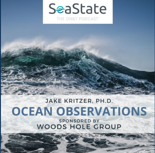
OOI’s Principal Investigator John Trowbridge and NERACOOS Executive Director Jake Kritzer have a lively discussion about the value of ocean observing systems on the SeaState podcast sponsored by Ocean News & Technology Magazine. Choose the podcast “Jake Kritzer on Ocean Observations” and listen in here.
Read More
RCA Video Shared via Oregon Coast Beach Connection
The Oregon Coast Beach Connection reports:
(Newport, Oregon) – There’s a whole lotta Sci-Fi-like action taking place off the Washington and Oregon coast, and no one really knows. Think the movie “Sphere” with a touch of “The Abyss,” throw in some X-Files and even a handful of high seas adventures, and you may have what’s going on with the Ocean Observatories Initiative (OOI), its enormous cabled array around the ocean floor, and the occasional research vessel – all studying the Axial Mount undersea volcano and the entirety of that area where the two tectonic plates meet…
Read More
New Power Sources Being Tested for Gliders
Battery longevity and funding are limiting factors for glider deployment at present. OOI Engineer Matt Palanza weighs in on what the future may hold should new power sources prove successful in an article in Wired magazine. Spoiler alert: the future looks bright!
[threecol_one][button link="https://www.wired.com/story/the-plan-to-build-a-global-network-of-floating-power-stations/" bg_color="#00a9dd" border="#004377" class="bigbutton"]Read Full Article[/button]
[/threecol_one]