
Posts Tagged ‘Regional Cabled Array’
Close-up View of An Active Hydrothermal Vent Now Easily Accessible
Now accessible on OOI’s Data Explorer: 47,000 hours of video from a high-definition (HD) camera at an active hydrothermal vent and underwater volcano, 1500 meters below the ocean’s surface!
The HD camera has been streaming live video since 2015, offering a close-up look at what’s been happening within the caldera of Axial Seamount, a highly active underwater volcano about 300 miles off the coast of Oregon. The SubC 1Cam video camera was modified by the Applied Physics Lab (APL) at the University of Washington for deployment on OOI’s Regional Cabled Array (RCA) in the NE Pacific Ocean. The camera is connected via a roughly 4 km dedicated 10 Gb extension cable that runs across the caldera from the camera in the ASHES vent field to Primary Node PN3B located near the eastern edge of the caldera. From there imagery are streamed at the speed of light over 521 km of submarine fiber optic cable to the shore station in Pacific City, OR.
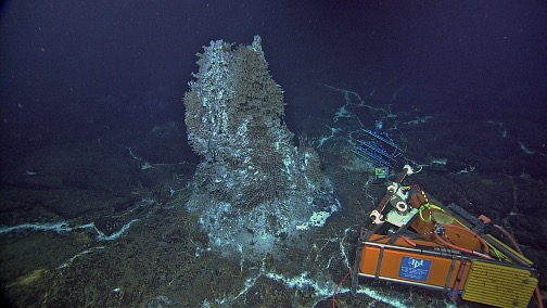
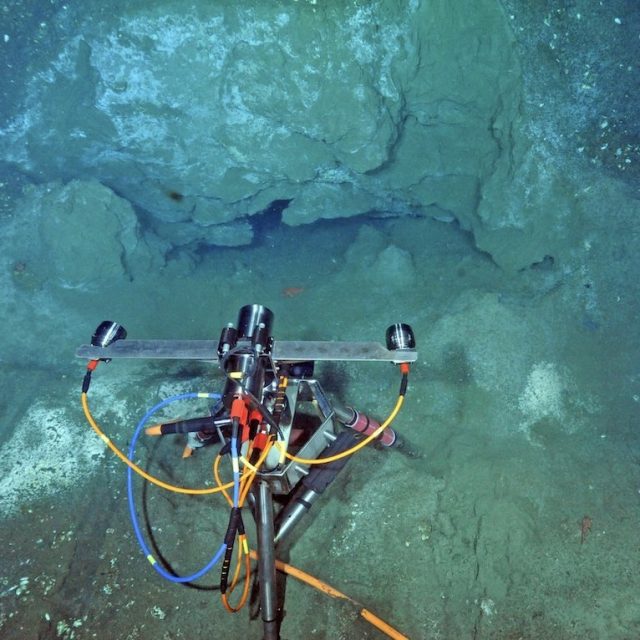
[media-caption path="https://oceanobservatories.org/wp-content/uploads/2024/05/HD-Camera.jpg" link="#"]The HD camera (orange triangular frame) images the 14 ft-tall actively venting hot spring deposit ‘Mushroom’ located within the caldera of Axial Seamount. Credit: NSF-OOI/UW/CSSF; Dive R1730; V14.[/media-caption]Up until recently, the footage has been available on the OOI raw data server in 14-minute increments as both high resolution MOV files and compressed MP4 formats, but the imagery was not easily reviewed or searchable. To make this unique nearly decade of footage more readily available to researchers, a new gallery feature on Data Explorer was created that allows researchers to easily view, search, and download the stunning video. All files created over each 24-hour period are used to create a sped-up, compressed, and time-stamped preview video allowing rapid overviews of daily events. Associated metadata and quick links provide access to the raw and log files, and a higher-resolution version of the preview is also available for download.
“The camera faces an active hydrothermal edifice called Mushroom that is completely encased in a dense biological community thriving in fluids emanating from the chimney walls,” explained Michael Vardaro, a research consultant for the RCA, who has been involved in OOI since construction began in 2011. “Mushroom hosts an active chemosynthetic community with 300 ºC hydrothermal fluids streaming out its top and from a small, highly dynamic chimney at its base. The camera allows the research community to see how the flow of hydrothermal fluid and the activity of all the different creatures living on it change over time, as well as the growth and evolution of the sulfide structure.”
Vardaro also said that the video allows viewers to watch what is happening in the short term. “You can catch predation events that include little scale worms nibbling on the gills of the tube worms. You can observe sea spiders [pycnogonids] crawling around the base of the chimney and watch as new vent openings develop. It’s a very changeable environment, because as the hydrothermal fluid hits the cold seawater, the metals and other chemicals dissolved in the superheated water precipitate out as solid minerals, creating fragile projections that then repeatedly crumble over time as the flow changes. The camera imagery provides important insights into linkages among geological, chemical and biological process at seismically active underwater volcano that has erupted in 1998, 2011, and 2015 and is poised to erupt again.”
[embed]https://youtu.be/oiDxkHWB3rI[/embed]The chimney stands about 14 feet high. The camera sits on a tripod at the base of the chimney with a pan and tilt unit. It follows an automated, 14-minute routine with the camera moving up, down and across the chimney and water column, stopping at pre-selected key areas of interest. What’s more, the APL team onshore can stop and alter the viewpoint if something interesting is happening or a question needs answering. “The Data Explorer now offers a hugely rich dataset of video footage extremely rare in mid-ocean ridge settings that offers a unique window into what is happening on the seafloor at an active hydrothermal vent site,” Vardaro added. “As development on the gallery continues, we also plan to add annotations and eventually incorporate machine learning and event detection to tag interesting biological features or significant changes to the site”.
In addition to the Data Explorer access, the live video stream is available every three hours for 14-minutes online (at 2:00, 5:00, 8:00, and 11:00 EDT & PDT). The camera also runs for 24 hours straight on the 10th and 20th of the month, with a 72-hour run on the 1st-3rd of the month as a means of gaining a fuller picture of activity at the site.
[embed]https://youtu.be/VjqduffxNyU[/embed]
Read More
QARTOD Flag Statistics Using Cloud-Based Resources and Zarr Data Formats
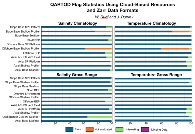
Central to the Regional Cabled Array (RCA) Quality Assurance/Quality Control (QA/QC) workflow is a cloud-based data harvest and visualization platform that allows for efficient and timely review of the high-frequency and high-density time series data streaming from RCA instruments. A key component of this workflow is a Zarr-based version of the OOI RCA data, a cloud optimized file format that stores metadata separately, allowing data chunks to be retrieved without loading the entire dataset. Using Zarr files and Amazon Web Services (AWS) cloud computing resources for QA/QC has made it possible to create a dashboard that is refreshed daily for multiple high-density datasets and parameters. This also results in minimization of both costs and OOI-Cyberinfrastructure load by appending only new data daily, with a full dataset refresh occurring only when necessary. Because the Zarr files contain time-series data records that include all variables served through M2M (Machine to Machine Learning), this workflow also allows for the efficient deep data review that is currently required for compiling and reviewing QARTOD (Quality Assurance/Quality Control for Real-Time Oceanographic Data) data flag tables.
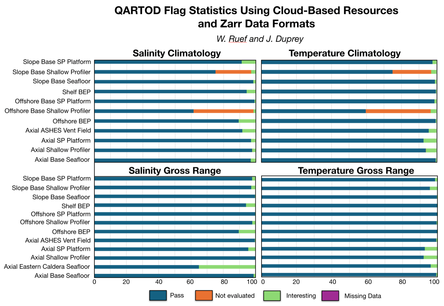
With the existing Zarr files, we were able to quickly access all active QARTOD flags in the RCA data streams for gross range and climatology and produce basic summary statistics for each parameter using minimal AWS cloud and data team resources. The figures above include the results from CTD (Conductivity, Depth, and Temperature) streams across the RCA for temperature and salinity, for both gross range and climatology QARTOD tests. In this initial compilation over 90% of all data points pass the gross range tests for temperature, and all except 2 pass gross range tests for salinity. Similar results were seen with the climatology tests, with nearly all streams having less than 10% of data points flagged as “suspect or interesting”. Most of the flags for non-passing data points in the climatology results were values of “not evaluated” in the Offshore and Slope Base Shallow Profiler streams. Our first set of investigations will focus on these streams to identify the cause for these flags. A suspected cause may be that the isoclines in the water column are not being accurately represented in the climatology depth bins.
Read More
RCA to be Offline on May 6 for Maintenance
Maintenance is scheduled on the Regional Cabled Array (RCA), which will require the system to be powered down at 0800 PT on Monday, 6 May. The system will be powered after completion of maintenance activities, but no later than 0800 PT on Tuesday, 7 May. Over the course of the week there may be temporary network interruptions as maintenance continues.
Read MoreA Post Doc Project with Ten Years of Ready-made Data
Katie Bigham has been around OOI for nearly a decade. Her involvement began in 2014 when she was an undergraduate at the University of Washington (UW) and took part in the marathon 83-day OOI Regional Cabled Array’s (RCA) final construction cruise that installed over 100 instruments, 9 moorings, 18 junction boxes and thousands of meters of extension cables. At the time, she was onboard as part of UW’s VISIONS program, an at-sea education program designed for students to experience all aspects of seagoing research and life aboard a global class oceanographic research vessel hosting a remotely operated vehicle (ROV). With a taste of Axial Seamount and hydrothermal vents on the ocean floor provided by her first sea-going experience, Katie landed on a direct career path to where she is today — a benthic ecologist post-doc at UW, using OOI data. It’s a repeat pattern for Katie. She first used RCA OOI data to write her senior thesis focused on life thriving at Southern Hydrate Ridge methane seeps before graduating with a degree in Oceanography from UW in 2017.
[media-caption path="https://oceanobservatories.org/wp-content/uploads/2024/04/2Katie_Studenst_sm-20230908_200403_startL4_ME-copy-scaled-1.jpg" link="#"]Chief Scientist Katie Bigham (back row, second from left) and VISIONS’23 students on the R/V Thompson during Leg 4 of the OOI-RCA operations and maintenance cruise. Credit: M.Elend, University of Washington. [/media-caption]After graduation, Katie took a couple of gap years, where she worked as a research associate for the OOI RCA and continued to go out on RCA’s annual recovery and deployment expeditions. She then decided to go for a PhD, relocating to Victoria University of Wellington in New Zealand during the height of COVID. While other colleagues’ research was stymied by the effects of the worldwide lockdown, Katie, luckily, had access to years of data on benthic communities in Kaikōura Canyon, a highly productive submarine canyon. As a benthic ecologist, she is interested in how and why biological communities change over time. Her dissertation focused on the impact of the magnitude 7.8 Kaikōura Earthquake in 2016 on the benthic community and it’s recovery. To assess this, she used co-registered detailed bathymetric and multicore data, as well as repeat photographic surveys from both before and after the disturbance.
“For a lot of these deep communities, we don’t really know what the baseline is for them. We don’t know what normal is,” Katie said. “I’m really interested in how to get the most out of multiscale, complex data sets to answer these important questions. Ship time is expensive. It’s hard to work in the deep sea and conditions there are really tough on instruments and equipment. That’s why projects like OOI are a great way to provide critical data over the long haul.”
During her PhD, Katie applied for and was awarded a National Science Foundation Postdoctoral Research Fellowship within the Ocean Sciences Division. “Funny, but my original thought was to try to Pandemic-proof my post-doc. I wanted to formulate a project that would advance our knowledge of benthic communities thriving in dynamic environments and be achievable in a 2-year time period. I was looking for something that would be cohesive and with readily available data that wouldn’t be at risk from COVID impacts, such as requiring laboratory studies. After considering available datasets, from my senior thesis work, I remembered the tens of thousands of images and terabytes of video collected at Southern Hydrate Ridge (SHR) since 2008 during the early days of the RCA and follow-on annual cruises, as well as the now nearly decade of data provided by the cabled instrumentation. Using these data, I was able to immediately start asking questions about long term temporal changes in biological communities associated with methane seeps. The wealth of high quality imagery collected at SHR, is nearly unparalleled for these environments.”
Katie is using imagery from the SHR digital still camera and ROV imagery for her research project. The cabled camera located at the Einsteins’ Grotto methane seep turns on its lights every half hour, takes three pictures, and then turns off. “It’s a highly dynamic environment where we’ve seen significant changes since the camera and the other equipment was first put in place there. This site hosts ‘vagrants’ or non-endemic megafauna, along with chemosynthetic bacteria that form extensive mats and clams with symbiotic bacteria. But, we also see rockfish, flounders, hagfish, eelpouts, and other visitors that come into the area, as well as soft corals and Neptunea nurseries because we think the seep is acting as a kind of an oasis for these organisms.”
[media-caption path="https://oceanobservatories.org/wp-content/uploads/2024/04/For-Katies-piece-good.camdsr1767_02826.sm_-scaled-2.jpg" link="#"]The SHR digital camera located at the Einsteins Grotto methane seep provides Katies with imagery for her research. Credit: OOI/UW/CSSF; Dive R1767; V14. [/media-caption]The visual imagery available is helping Katie better understand cold seeps and how and why they are attracting other species. “Better understanding of methane seeps is important because of the potential interest in mining them, and because places like SHR are deemed “essential fish habitats.” Hence, we need to understand their relevance to fish stocks, including that perhaps they may be serving as nursery areas. Over 1,000 sites along the Cascade Margin are known to venting methane, but less than ~five have been studied in any detail.”
The imagery allows researchers like Katie to begin to look at the temporal dynamics of these communities and determine whether they respond to particular cycles, such as tides, changes in the chemosynthetic concentrations, or pulses of macroalgae from the surface, as well as the long term impacts of ocean warming. “The images are helping us understand the colonization of specific organism types and how benthic communities are using these sites over time. Because the datasets are so high-resolution with data every half hour, we can look at larger annual cycles and changes from season to season and year to year,” Katie added. Other SHR co-located cabled instrumentation also allows for investigation of changing conditions due to seismic events, for example.
The Challenges of Big Data
Katie’s task over the next two years is not an easy one. The digital still camera alone produces over 50,000 images a year. These data, coupled with terabytes of 4K and HD imagery, as well as thousands of images taken during ROV dives in the area, creates a huge amount of imagery to process. She’s tackling this effort in two stages: The first is to bring in machine learning and computer vision techniques to aggregate the datasets. Once that is accomplished, there’s the bigger task of looking at the imagery and classification output to determine what can be learned about the inhabitants of the seep area.
The first task to incorporate AI into helping sort the imagery is to label various features. “Obviously, the holy grail would be, the computer just does it for you. But because this still camera is looking at generally the same scene all the time, it’s ripe for putting an event detector or machine assisted annotation, where the computer can help differentiate today’s picture from yesterday’s picture,” she added. With such computerized assistance, researchers like Katie can then spend their time looking at the animals and observing their behavior rather than having to annotate each image. She gave an example: sometimes a crab will find a home on the camera and hang out there, blocking images of the area. A computer “trained to identify when this happens,” could allow researchers to avoid this occurrence when they can’t see behind the crab.
“I’m super stoked about this project. It’s been an exciting thing to be working on and it’s been really cool to bring together my scientific background and access to RCA-OOI data,” Katie said. “I’m developing automated digital analyses techniques that when I worked on my undergraduate thesis thought it’d be so cool to do and I’m doing it now.”
With a powerful computer and multiple monitors in hand, in two years when her post doc ends (December 2025), Katie will have moved the world of AI forward to analyze an unprecedented amount of data within this marine ecosystem, resulting in one or more scientific papers about the temporal dynamics of benthic communities and how and why they change over time–in her words “a nice, cohesive, achievable effort!”
Read More
Diel Vertical Migrators Respond to Short-Term Upwelling Events
Sato and Benoit-Bird, in their 2024 publication, explore how animals remain in a productive yet highly advective environment in the Northern California Current System using NSF OOI Regional Cabled Array (RCA) and Endurance Array (EA) data from the Oregon Shelf site. They characterized fish biomass using upward-looking active bio-acoustic sonar data from the RCA and interpreted results in consideration of upwelling and downwelling using EA wind data and combined cross-shelf velocity data from the RCA and EA.
Acoustic scatterers, consistent with swim bladder-bearing fish, were only present during the downwelling season as these animals avoided the cold waters associated with strong upwelling conditions in summer and fall. Fish responded to short-term upwelling events by increasing the frequency of diel vertical migration. Throughout the study, their vertical positions corresponded to the depth of minimum cross-shelf transport, providing a mechanism for retention. The observed behavioral response highlights the importance of studying ecological processes at short timescales and the ability of pelagic organisms to control their horizontal distributions through fine-tuned diel vertical migration in response to upwelling.
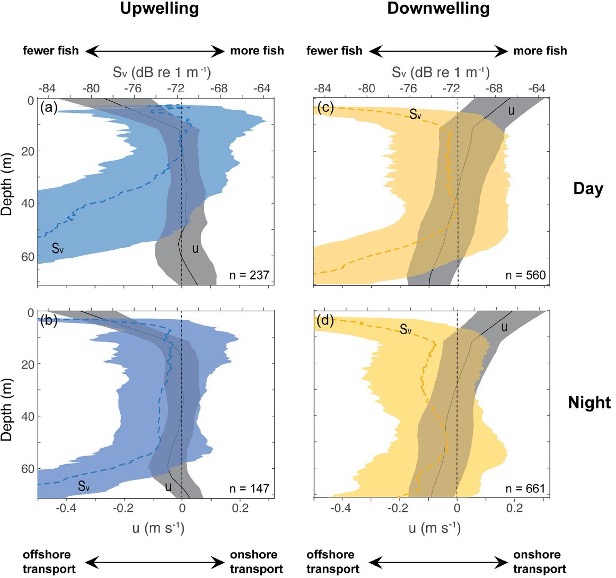
Time series data provided by the combined EA and RCA data made it possible for Sato and Benoit-Bird to perform consistent statistical analyses of bio-acoustic sonar, wind and ocean velocity data [Figure 22, after Figure 4, Sato and Benoit-Bird (2023)]. The vertical positions of scattering layers relative to the cross-shelf velocities revealed the careful positioning of animals at the depth of minimum onshore- offshore transport. The authors focused on cross-shelf transport, the most significant mechanism affecting population dynamics of pelagic organisms. During strong upwelling periods, cross-shelf velocities were strong near the surface and became nearly zero below 15-m depth. The peak scattering layers were in the upper 20 m of the water column during daytime, but organisms avoided the strong offshore currents at the surface (Figure 22a). At night, the scattering layers expanded their vertical distributions, but avoided the region nearest the bottom where onshore currents were strong (Figure 22b). During downwelling periods, scattering layers were located at the depth of minimal transport during day and night and animals avoided strong onshore currents near the surface and offshore currents near the bottom (Figures 22c and 22d).
[media-caption path="https://oceanobservatories.org/wp-content/uploads/2024/02/Science-Highlight-Feb-2024.jpg" link="#"]Figure 22: The influence of upwelling and downwelling on diel vertical migration[/media-caption]Sato and Benoit-Bird show that animals respond to the risk of offshore advection through active changes in their vertical movement that depend on upwelling conditions at daily time scales. Rapid behavioral response of animals to short-term upwelling events highlights their ability to finely tune their vertical positions relative to physical forcing which ultimately controls their horizontal distributions. This work expands our understanding of the ecological role of diel vertical migration beyond its role as a predator avoidance strategy and reveals a tight coupling between animal behavior and physical forcing.
Vertical profiles of cross-shelf velocities (u; gray, solid lines) and volume backscattering strength (Sv; colors, dotted lines), shown as mean ± standard deviations, during (a, b) strong upwelling periods with diel vertical migration and (c, d) strong downwelling periods without diel vertical migration. Data points qualified for strong upwelling and downwelling periods were selected from the time series over 14 months. Negative values in u indicate offshore transport and positive values indicate onshore transport, and larger Sv values suggest higher density of swim bladdered fish.
Read More
NSF Funds Creation of Offshore Subduction Zone Observatory as part of OOI’s Regional Cabled Array
With support from the US National Science Foundation, the Ocean Observatories Initiative’s (OOI) Regional Cabled Array (RCA) will be expanded to include an Offshore Subduction Zone Observatory on the Cascadia margin. This new addition to the RCA will produce real-time data to help answer fundamental questions about how subduction zone faults work and can enhance existing systems for earthquake and tsunami warning.
The University of Washington (UW) will lead a team that includes Scripps Institution of Oceanography to implement the “Creating an Offshore Subduction Zone Observatory in Cascadia with the Ocean Observatories Initiative Regional Cabled Array” (COSZO) project to add geohazard sensing instruments, including seismic sensors and calibrated seafloor pressure gauges, to the existing NSF-funded Regional Cabled Array. The UW received one of four Mid-Scale Research Infrastructure-1 (Mid-scale RI-1) awards announced by the US National Science Foundation for Fiscal Year 2023-2024.
“The four awardees NSF has selected — the University of Rochester, Iowa State University, the University of Washington, and the University of Southern California — exemplify the most novel, innovative infrastructure being designed and built in our country to advance the best ideas and train the highly skilled talent in science and engineering for our future,” said NSF Director Sethuraman Panchanathan. “By investing in the most innovative infrastructure, NSF aims to strengthen opportunities for all Americans and advance the frontiers of science and technology.”
Earth’s greatest geological hazards are concentrated in subduction zones. These places where two tectonic plates converge and collide not only produce large-scale earthquakes but suffer from their cascading effects such as devastating tsunamis. The Cascadia subduction zone, spanning the offshore coasts from northern California to British Columbia, hosts earthquakes up to magnitude 9 every few hundred years, the last of which was in 1700. The RCA currently brings power and internet into the ocean offshore of Newport, Oregon.
Today seismic and geodetic sensor networks on land in the Pacific Northwest can quickly alert authorities to geohazards, but the offshore region, where almost all the locked plate boundary and expected earthquake slip would occur, is largely devoid of such instruments.
“There’s a huge amount of interest in subduction zones, from Sumatra to Chile,” said oceanographer William Wilcock, one of several investigators on this project. “Because of the risks and hazards of subduction zones, the National Science Foundation and others have invested in studies to understand a wide variety of subduction zones because they all behave a bit differently and can have devastating impacts.”
“This award will make it possible for scientists to have a front-row seat of the subduction zone with real-time data from 2900 to 80 meters below the ocean’s surface” said Deborah Kelley, Principal Investigator of the Regional Cabled Array. “It builds upon some of the ideas that motivated the OOI. It clearly demonstrates the opportunities for growth through the RCA’s ability to provide power and unprecedented bandwidth to instruments that are monitoring conditions around the clock on the seafloor and throughout the water column. From this will come important new discoveries about how our planet works.”
“We are excited by the addition of COSZO to the Regional Cabled Array,” said Jim Edson, who leads OOI’s Program Office at Woods Hole Oceanographic Institution. “The data made available from COSZO via NSF’s Seismological Facility for the Advancement of Geoscience, will help scientists and engineers understand the hazards from earthquakes and tsunamis, with the potential for improvement of early warning systems, which can ultimately help save human lives. “
A story about the COSZO project can be found here.
——————————————
The Ocean Observatories Initiative is a science-driven ocean observing network that delivers real-time data from more than 900 instruments to address critical science questions regarding the world’s oceans. The National Science Foundation has funded the OOI, under Cooperative Agreement No. 1743430, to encourage scientific investigation. OOI data are freely available online to anyone with an Internet connection.
The U.S. National Science Foundation is an independent federal agency that supports science and engineering in all 50 states and U.S. territories.
Any opinions, findings, and conclusions or recommendations expressed in this material are those of the author(s) and do not necessarily reflect the views of the National Science Foundation.
October 19, 2023
Read More
RCA’s Ninth Expedition: Best Laid Plans
Written by Deborah Kelley, PI of the Regional Cabled Array, September 17, 2023
The Regional Cabled Array, spanning the Cascadia Margin and Juan de Fuca tectonic plate and water depths of ~260 ft to 9500 ft, is an engineering marvel. It is the most advanced underwater observatory in the oceans comprised of >900 km of high power- and -bandwidth submarine fiber optic cables, a highly diverse suite of >150 instruments, and state-of-the-art moorings with instrumented profilers, which since 2014 have traversed >50 million meters of ocean water! The underwater substations and instruments are installed in some of the most extreme environments on Earth, including the most active submarine volcano off the Oregon-Washington coast ‘Axial Seamount’. Here, extension cables traverse glass covered lava flows and instruments are inserted into underwater, acidic hot springs, hot enough to rapidly dissolve aluminum and melt lead. Profiling science pods on moorings that traverse ocean depths from ~650 ft to 16 ft nine times a day, must be ‘smart’ enough to keep “their heads down” when storms, common in the waters of the NE Pacific Ocean, create waves reaching 30 feet in height or more. Yet, it is within these environments that the cabled observatory has thrived, largely due to its design, rigorous testing, and the hard work of the RCA Team, and Jason and Thompson crews during the annual operations and maintenance expeditions, such as the one nearing its end now: VISIONS’23.
[media-caption path="https://oceanobservatories.org/wp-content/uploads/2023/09/Katie_Studenst_sm-20230908_200403_startL4_ME-copy-scaled-1.jpg" link="#"]First time RCA Chief Scientist Katie Bigham (top row, second from left) with Co-Chief Scientist J. Nelson (far left), RCA technician Andrew Paley (top row, far right) and Leg 4 VISIONS students. Katie was a VISIONS’14 student. Credit: M. Elend, University Washington, V23.[/media-caption]Planning for the RCA 2023 cruise began over a year ago as there is a high demand for NSF’s global class ships that operate throughout the worlds’ oceans. Scheduling is a complex process with lots of moving parts involving minimization of transit lengths, awareness of optimum weather windows, and researchers’ schedules. As soon as lasts year’s cruise ended, RCA instruments recovered in the Fall of 2022, were sent back to vendors for calibration and refurbishment, parts and cables were ordered, and the RCA teams’ eyes were already looking to this year. By late Spring, most of the refurbishment and integration testing of platforms and instruments was complete, the four Legs were planned out in detail, and the nearly 144 berthing assignments were finished. The careful layout of equipment on the aft deck of the Thompson was of critical importance, with nearly 200,000 lbs of gear on the fantail and the need for deck space free of gear to allow for mooring cables to be recovered and redeployed.
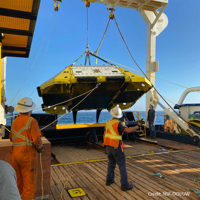
So that brings us to now, nearing the end of Leg 4, which will end on September 18 when the Thompson arrives back to Newport, Oregon. Working at sea is just tough, no way around it, and best laid plans are often adjusted before even leaving port (such as happened at the start of Legs 1 and 3) as the weather gods do not care about our schedule. The prior three Legs experienced numerous perturbations due to the loss of a week of operational days when the ROV Jason could not dive due to bad weather and additional loss of time due to ROV issues. Plans were adjusted on the ‘fly’ over and over again to best accomplish all of our goals, including the recovery and re-installation of >100 instruments. Because of this, some work was pushed out into Leg 4, an already complicated Leg because it was especially dependent on having good sea state conditions due to the planned installation and recovery of two deep profiler moorings, the largest of which rises >8000 ft above the seafloor at the base of Axial Seamount.
[media-caption path="https://oceanobservatories.org/wp-content/uploads/2023/09/Float.jpg" link="#"]The float for the Deep Profiler mooring at the Oregon Offshore site being brought onboard the Thompson. Credit: M. Elend, University of Washington; V23.[/media-caption]Almost immediately, Leg 4 plans were adjusted following the first operation – the recovery and reinstallation of the Deep Profiler Mooring at the Oregon Offshore site. The communications and power ‘dock’ at the base of the mooring would not respond after plugging in the seafloor extension cable that connects it to a small substation (junction box) on the seafloor. While the engineers tested various aspects of the cable, and puzzled over the cause, the RCA team continued their work at the Slope Base site. There, the Deep Profiler mooring cable was cleaned, and the instrumented profiling vehicle deployed in 2022 was replaced. Following this operation, the Thompson transited ~ 18 hrs to the base of Axial Seamount, where, instead of turning the mooring, it was decided to just swap out the vehicle, similar to Slope Base.
[media-caption path="https://oceanobservatories.org/wp-content/uploads/2023/09/getting-ready-to-bring-in-the-cable.sm_.PD01B_20230909_132549_recovery_ME-copy-scaled-1.jpg" link="#"]RCA engineers and ship crew getting ready to spool cable onboard from the Offshore Deep Profiler Mooring. Credit: M. Elend, University of Washington, V23.[/media-caption]With this work complete, a series of dives was planned to support researchers’ projects funded by the National Science Foundation outside of the Ocean Observatories Initiative. These dives were to include sampling of hydrothermal vent fluids to investigate viruses and microbes in these extreme environments, the recovery and installation of cabled CTD instruments to test the hypothesis that highly saline fluids are flushed from beneath the seafloor shortly following an eruption, and the recovery of a cabled multibeam sonar (COVIS) focused on making unique fluid flux measurements in the ASHES hydrothermal field. Time allowing, equipment on the Thompson would be used to “talk” to an acoustic array (FETCH) installed in the volcanoes’ caldera for investigation of deformation within this highly active volcano.
There was, however, a small window to complete this work. After investigation of the Deep Profiler Mooring at the Oregon Offshore site, it was determined that the Thompson would need to transit nearly 300 miles back to this area, to install a new extension cable, and/or recover and redeploy the mooring with the one just recovered at the beginning of Leg 4 – an exercise that could take 2-3 days. Indeed, Jason had other ideas because while working at the summit of Axial, there was an issue with the specialized hydrothermal vent sampler on the vehicle, followed by a failure of the power system, preventing more dives. The Jason team worked very hard overnight to fix the power supply, but with ever decreasing time to get the Deep Profiler work done back on the margin, it was decided to abandon remaining work at Axial (a very tough decision as this would impact researchers work over the entire next year) and head to the Offshore site. This also allowed optimal use of the transit time to thoroughly test the repaired power system for Jason. It also provided time for the APL engineers to ready a new extension cable for the Deep Profiler mooring, hoping that this simple fix would solve the problem, and to catch up on much needed sleep. With huge relief, the replacement of the extension cable did the trick on the first dive at the Offshore site. The docking station powered up and the vehicle completed its test profiling run — opening up a three-day window for additional work.
[media-caption path="https://oceanobservatories.org/wp-content/uploads/2023/09/ratail-sulis_20230916210321_rattail_probe_closeup.jpeg" link="#"]A rattail fish came to investigate the UFO fluid sampler as it obtained fluids for Dr. Rika Anderson at Marker 113, a diffuse flow site in Axial Caldera. Credit: UW/NSF-OOI/WHOI, Dive J2-1559, V23.[/media-caption]With a sigh of relief and desperately wanting to support the external researchers work, Chief Scientist, Katie Bigham, asked Captain Eric to turn the ship around and head back out to Axial Seamount. So away they went, following the same track line they had completed less than 24 hrs before. During the next 34 hrs, Jason pounded out the dives and completed all but the FETCH work, before it was time to once again head back to Slope Base to complete two final tasks.
The above description is only part of what goes on during the various legs of these RCA expeditions. It is hard to convey what it is like to be a Chief Scientist on an RCA cruise. As with this cruise, decisions must be made rapidly, but also strategically, with an eye towards the end of a leg and cruise – “Will this decision prevent other work from happening? What is the weather going to be like in 2-3 days? What is the status of equipment? How are the students doing and how are their projects going? Do they need help? Is the team getting enough sleep? Should we transit to another site to help with this? On and on it goes…Awareness of these questions and outcomes are always in a Chief Scientists’ thoughts and are combined with the everyday tasks of writing plans for the next day and operational reports.
This was Katie’s first time being a Chief Scientist. She has done an exceptional job making adjustments to our “best laid plans” on a cruise that has been one for the books in the near decade of RCA operations and maintenance expeditions.
For more information on the RCA’s ninth operations and maintenance expedition, visit here.
Read More
Soundscape Ecology Through Automated Acoustic-Based Biodiversity Indices
Soundscape Ecology Through Use of Automated Acoustic-Based Biodiversity Indices: A Test Using RCA Broadband Hydrophone Data. Adapted by OOI from Ferguson et al., 2023.
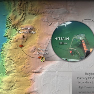
[media-caption path="https://oceanobservatories.org/wp-content/uploads/2023/07/Screenshot-2023-07-27-at-3.53.41-PM.png" link="#"]Figure a) Location of Regional Cabled Array broadband hydrophones used in this study. b) Acoustic Complexity Index associated with mammal calls, fish sounds, and anthropogenic noise. (After Ferguson et al., 2023).[/media-caption]Ferguson’s et al., 2003 paper explores the use of myriad biodiversity indices, generated by automated acoustic classifications, using data from three of the Regional Cabled Array (RCA) broadband hydrophones. As the authors point out, human in-the-loop evaluation of marine species and anthropogenic noise from very large data volumes generated by passive acoustic sensors is formidable. Yet, identification of marine organisms and anthropogenic noise is increasingly important for biodiversity conservation and ecosystem monitoring. Automated biodiversity indices have been utilized in terrestrial environments, but only limited studies have used machine learning to study soundscape ecology in marine systems. This study used broadband hydrophone (HYDBBA) data from Slope Base on the Shallow Profiler Mooring (200 m water depth and ~ 100 km offshore), at Oregon Offshore (580 m water depth and ~ 72 km offshore), and the Oregon Shelf site (80 m water depth and ~ 16 km offshore) (Figure 28a) to examine seven diversity indices. Note, these study sites are valuable to making progress in soundscape ecology because the Cascadia Margin is characterized by very high biological productivity impacted by the California current, it is the site of intense shipping lanes, and because of the availability of continuous, real-time acoustic data streams provide by the RCA.
In this initial study, Ferguson et al., evaluated one month of data from the three sites: January 2017 for HYBDDA 103 and 106 and April 2018 for HYBDDA 105. Five minute files were used with 7,101 files for Slope Base, 4,725 files for Oregon Offshore, and 6,410 files for the Oregon Shelf. Data from these instruments had been previously annotated, providing ground truthing for machine learning results. Periods of vocalization of marine mammals occurred less frequently at Slope Base. Three months of data were reviewed to examine periods of mammal vocalizations and anthropogenic sounds.
Identifying the relationship between numerous acoustic indices and species characteristics is complex and requires attention to a significant number of factors and computation of multiple tests, as described in detail in this paper. The Acoustic Complexity Index (ACI, Figure 28b), is generated from an algorithm to quantify biological sounds based on intensity, it is the most commonly used index to assess acoustic indices in marine systems, and has been demonstrated useful in identifying species diversity. Results from this work show that ACI measurements increased during vocalizations by dolphins and sperm whales. However, evaluation of the seven indices show that biodiversity cannot be explicitly determined from any single acoustic index. A significant finding from this study is that true assessment of large-scale ecosystem health and changes in indicator species, which may be due to differences in seasonal and interannual variability, requires co-located physical and chemical oceanographic data. The authors note that the RCA and Endurance Array instrumentation provides “an ideal scenario for accurately monitoring system health”.
_______________________________________________
Ferguson, E.L., H.M. Clayton, and T. Sakai (2023) Acoustic Indices Respond to Marine Mammal Vocalizations and Sources of Anthropogenic Noise. Frontiers in Marine Science. 10:1025464; doi: 10.3389/fmars.2023.1025464.
Read MoreRegional Cabled Array VISIONS Expedition
RCA Science and Data in K12 Classrooms
Dr. Kareen Borders, Executive Director, STEM Instruction and Outreach, South Kitsap School District and Executive Director of West Sound STEM Network and Dr. Deb Kelley, Professor, School of Oceanography, University of Washington and Director of the Regional Cabled Array, Ocean Observatories Initiative (OOI) teamed up to bring Regional Cabled Array science and data into K12 classrooms in northwest Washington.
After holding a series of curriculum development workshop, classroom units and lessons are now available on the Regional Cabled Array’s Interactive Ocean website. The teaching tools are are the products of a pilot program, funded by the National Science Foundation, that brought together a professional learning community of West Sound STEM Network K12 teacher leaders from northwest Washington school districts, and private and Tribal schools, in partnership with University of Washington, School of Oceanography scientists. They engaged in a series of K12 Ocean Observatories Initiative (OOI) education curriculum development workshops centered on marine science through use of Regional Cabled Array data.
This cohort of middle and high school teachers developed a series of OOI-integrated STEM Units utilizing stunning imagery from the OOI/ University of Washington Interactiveoceans website and live data from more than 150 instruments streaming from the Regional Cabled Array underwater observatory off the coast of Oregon. The use of rigorous and relevant instructional practices and culturally relevant pedagogical design connects students to technology as a tool for meaningful STEM learning and exploration of STEM career pathways.
The workshops resulted in cloud-based educational packages that cover Plate Tectonics and Volcanoes utilizing the Juan de Fuca Plate and Axial Seamount as prime examples, geohazards focused on seismicity along the Cascadia Subduction Zone and tsunamis, and climate change with an emphasis on heat waves. To access and use the workshop material, visit RCA’s link here.
Read More