
Posts Tagged ‘Regional Cabled Array’
Understanding Factors Controlling Seismic Activity Along the Cascadia Margin
Excerpted from the OOI Quarterly Report, 2022.
The Cascadia Subduction Zone extends from northern California to British Columbia. It has experienced magnitude 9 megathrust events with a reoccurrence rate of every ~500 years over the past 10,000 years [5] and large earthquakes at intervals of ~ 200-1200 years [6]. The last Cascadia megathrust rupture occurred on January 26, 1700 [5]. When the next event occurs, it is estimated that financial losses would be ~ $60 billion USD with substantial loss of life. Hence, there is significant research focused on understanding seismic processes along this ~ 1100 km subduction zone, the generation of slow earthquakes, and causes of variation in seismicity along strike.
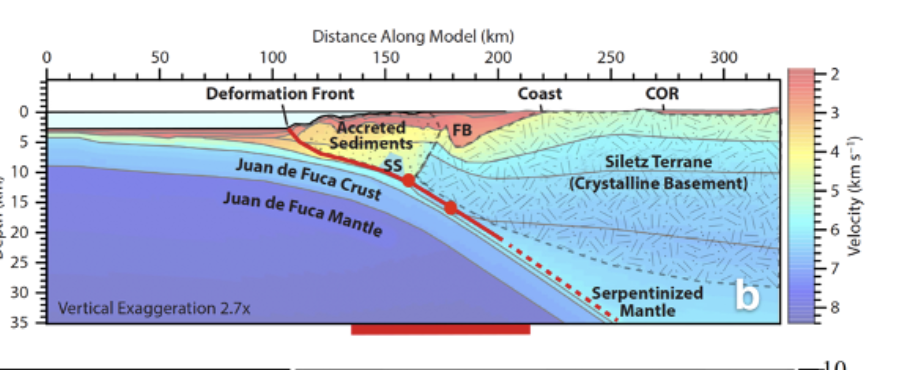
[media-caption path="/wp-content/uploads/2020/10/RCA-science-highlight-pic.png" link="#"]Figure 20. Earthquake generating processes in the central portion of the Cascadia Margin. a) Location of ≥4 magnitude earthquakes (red dots) 1989-August 2017 from the Advanced National Seismic System Comprehensive Earthquake catalog. The short dashed line is the 450°C contour, and short-long dashed line is the updip limit of tremor from 2005-2011 [after 1]. b) Interpreted cross section through the Cascadia Subduction Zone crossing the location of the Regional Cabled Array (RCA) margin sites. Red dots are projected positions of two 4.7-4.8 magnitude earthquakes in 2004 [1]. Basement rocks of the upper plate – the Siletz Terrane – comprise accreted anomalously thick mafic oceanic crust [1-3]. SS indicates the position of a subducted seamount west of the Siletz terrane [1]. c) Detected seismicity (blue dots – 222 earthquakes) approximately centered on the location of RCA ocean bottom seismometers on the Juan de Fuca Plate at Slope Base and on the margin at Southern Hydrate Ridge (purple triangles) [4]. Dot size is proportional to magnitude. A southern cluster centered at depths of ~ 5-10 km, is associated with the location of the subducted seamount, while the northern cluster may be associated with possibly accreted seamount [4].)[/media-caption]Understanding the factors that control seismic events was/is a major driver in the siting of OOI-RCA core geophysical instrumentation on the southern line of the Regional Cabled Array: the RCA is one of the few places in the world where seismic-focused instrumentation occurs on both the down-going tectonic plate and on the overlying margin. The offshore network is especially valuable in determining earthquake source depths that inform on interpolate dynamics [1]. The central section of the Cascadia Margin is the only area that experiences repeat, measurable shallow crustal earthquakes [1-3]. RCA data flowing from the seismic network at Slope Base and Southern Hydrate Ridge, and from the Cascadia Initiative are providing new insights into factors controlling seismicity along this portion of the margin [1,4] (note because the RCA broadband seismometers are buried, they have lower noise levels at higher frequencies than the Cascadia Initiative instruments [1]).
Most recently, Morton et al., [4] examined data from the Cascadia Initiative [7] and the RCA. Shallow earthquakes are focused in the area of a subducted seamount [1-3] and another cluster to the north (Fig. 1b and c). Based on earthquake locations, they suggest that subduction of the seamount produces stress heterogeneities, faulting, fracturing of the overriding Siletz terrane (old oceanic crust) (Fig 1b), and fluid movement promoting seismic swarms. Because this area is the most seismically active area along the Cascadia margin, it is an optimal area to examine the impacts of local earthquakes on, for example, gas hydrate deposits and fluid expulsion.
[1] Tréhu, A.M., Wilcock, W.S.D., Hilmo, R., Bodin, P., Connolly, J., Roland, E.C., and Braunmiller, R., (2018) The role of the Ocean Observatories Initiative in Monitoring the offshore earthquake activity of the Cascadia Subduction Zone. Oceanography, 31, 104-113.
[2] Tréhu, A.M., Blakely, R.J., and Williams, M., (2012) Subducted seamounts and recent earthquakes beneath the central Cascadia Forearc. Geology, 40, 103-106.
[3] Tréhu, A.M., Braunmiller, J., and Davis, E., (2015) Seismicity of the Central Cascadia Continental Margin near 44.5° N: a decadal view. Seismological Research Letters, 86, 819-829.
[4] Morton, Bilek, S.L., and Rowe, C.A. (2018) Newly detected earthquakes in the Cascadia subduction zone linked to seamount subduction and deformed upper plate. Geology, 46, 943-946.
[5] Satake, K.Shimazaki, K., Tsuji, Y., and Ueda, K., (1996) Time and size of a giant earthquake in Cascadia inferred from Japanese tsunami records of January 1700. Nature, 379, 246-249.
[6] Goldfinger, C., Nelson, C.H., Eriksson, E., et al., (2012) Turbidite event history: Methods and implications for Holocene paleoseismicity of the Cascadia Subduction Zone. US Geological Survey Professional Paper (1661-F), 184 pp.
[7] Toomey, D.R., Allen, R.M., Barclay, A.H., Bell, S.W., Bromirski, P.D. et al., (2014) The Cascadia Initiative: A sea change in seismological studies of subduction zones. Oceanography, 27, 138-150.
Read More
Partnerships Expand Use of OOI Data
The OOI’s primary mission is to make its data widely available to multiple users. One way it achieves this, on a broad scale, is by establishing partnerships with other organizations that also distribute ocean observing data. For example, OOI currently partners with the Integrated Ocean Observing System (IOOS), which provides integrated ocean information in near real-time and tools and forecasts to apply the data, the National Data Buoy Center (NDBC), which maintains a network of data collecting buoys and coastal stations as part of the National Weather Service, the Global Ocean Acidification Observing Network (GOA-ON), which uses international data to document the status and progress of ocean acidification, and Incorporated Research Institutions for Seismology (IRIS), a consortium of over 120 US universities dedicated to the operation of science facilities for the acquisition, management, and distribution of seismological data.
NANOOS: Making data relevant for decision-making
NANOOS, the Northwest Association of Networked Ocean Observing Systems, which is part of IOOS, has been operational since 2003, establishing trusting, collaborative relationships with those who use and collect ocean data in the Pacific Northwest. NANOOS has been an exemplary partner in ingesting and using OOI data. Part of its success lies in advance planning. NANOOS, for example, had determined that OOI assets, in addition to achieving the scientific goals for which they were designed, could fill a data void in IOOS assets running north and south in an area between La Push, WA, and the Columbia River, well before the OOI assets came online.
[media-caption type="image" class="external" path="https://oceanobservatories.org/wp-content/uploads/2020/09/Screen-Shot-2020-09-22-at-2.25.24-PM.png" alt="Endurance Array" link="#"]OOI’s Coastal Endurance Array provides data from the north and south in an important upwelling area in the northeastern Pacific. Gliders also traverse this region, with glider data available through both the IOOS Glider Data Assembly Center and the NANOOS Visualization System. Credit: Center for Environmental Visualization, University of Washington.[/media-caption]According to Jan Newton, NANOOS executive director at the University of Washington, “One of the reasons NANOOS is so effective is that our guiding principle is to be cooperative and not compete. If the public is looking for coastal data, for example, we want to make sure they can access it and use it, rather than having them trying to sort through whether it is a product of IOOS or OOI. We operate with the philosophy of maximizing the discoverability and service of the data and OOI has been a great partner in our mission. We’ve been really happy about how this partnership has played out.”
[media-caption type="image" class="external" path="https://oceanobservatories.org/wp-content/uploads/2020/09/Regional-Cable-Array-revised-.jpg" alt="Revised RCA" link="#"]OOI’s Regional Cabled Array also contributes data in the NANOOS region from its Slope Base and the Southern Hydrate Ridge nodes. Credit: Center for Environmental Visualization, University of Washington.[/media-caption]NANOOS has made a huge effort on its data visualization capabilities, so people can not only find data, but look at it in a relative way to use it for forecasting, modeling, and solving real-world problems. OOI data are integral in helping support some of these visualization and modeling efforts, which commonly play a role in situations facing a wide cross-section of society.
An example of this applicability played out in improved understanding of hypoxia (oxygen-deficient conditions) off the coast of Oregon, which had resulted in mass mortality events of hypoxia-intolerant species of invertebrates and fish, in particular, Dungeness crabs. Allowing access through NANOOS to near real-time oxygen data from OOI assets has allowed the managers and fishers to come up with some plausible solutions to maintaining this valuable resource. The Dungeness crab fishery is the most valuable single-species fishery on the U.S. West Coast, with landed values up to $250 million per year, and plays an enormous cultural role in the lives of tribal communities in the region, as well.
[media-caption type="image" class="external" path="https://oceanobservatories.org/wp-content/uploads/2020/09/Dungeness-Crab.jpg" alt="Dungeness Crab" link="#"]OOI oxygen data have helped resource managers and fishers maintain the valuable Dungeness crab fishery, which is the most valuable single-species fishery on the U.S. West Coast.[/media-caption]Researcher Samantha Siedlecki, University of Connecticut, reports that in late June of 2018, for example, fishers in the region were pulling up dead crabs in pots without knowing the cause. Scientists accessed near real-time OOI observations through the NANOOS data portal and found that the Washington Inshore Surface Mooring of the Coastal Endurance Array (EA) had measured hypoxia from June 7th onwards. So, the data confirmed real-life conditions and explained the crab mortalities.
This is important because such occurrences are helping to confirm models and enhance forecasting to better manage these events by providing guidance to fishers and resource managers. In this instance, the forecast indicates what regions will likely require reduced time for crabs to remain “soaking,” caged in the environment during hypoxia events, to ensure crabs are captured alive, and also aid in spatial management of the fishery itself. OOI data will play a role in continual improvements in forecasting in this region and the fishery by providing data during winter months, ensuring historical data are available and quality controlled for use in forecasting, and continuing to serve data in near real-time.
Adds Newton, “I can’t tell you how many OOI and other PIs come up and tell me how they love that their data are having a connection to real world problems and solutions. It makes their research go farther with greater impact by being part of this NANOOS network.”
Explains Craig Risien, Coastal Endurance Array senior technician at Oregon State University, “OOI is collecting an incredible wealth of data, offering a treasure chest of material to write papers, write proposals, include in posters, and now it is being used in practical ways for finding scientific solutions to environmental problems. Every time we look at the data, there’s a new story to tell. We always find something new, something interesting, and encourage everyone to have a look and experience the same usefulness and excitement about OOI data.”
Sharing OOI data
The OOI is in talks with the IOOS regions serving the Northeast Atlantic and the Mid-Atlantic to see how OOI data might enhance their networks, as well. The OOI also has been providing data to the National Data Buoy Center since 2016, supplementing the data collected by NDBC’s 90 buoys and 60 Coastal Marine Automated Network stations, which collectively provide critical data on unfolding weather conditions. And, the OOI has been providing data to Global Ocean Acidification Observing Network (GOA-ON), since mid-2019, ground-truthing on site conditions in real to near real-time, which is critical to understanding conditions contributing to ocean acidification and improving modeling capabilities to determine when it might occur. OOI’s Regional Cabled Array has been providing seismological, pressure and hydrophone data to Incorporated Research Institutions for Seismology (IRIS) since 2014, providing a wealth of data from Axial Seamount and on the Cascadia Margin. For example, on April 24, 2015 a seismic crisis initiated at the summit of Axial Seamount with >8,000 earthquakes occurring in 24 hrs, marking the start of the eruption. Starting at 08:01 that same day, the network recorded ~ 37,000 impulsive events delineating underwater explosions, many of which were associated with the formation of a 127 meter thick lava flow on the northern rift.
Data examples
If you would like to test drive some of the OOI data in NANOOS, NDBC, and GOA-ON, here are some examples below:
IOOS
· OOI data in the NANOOS Visualization System (NVS)
NDBC
· Coastal Endurance Array data (Stations 46097, 46098, 46099, 46100)
· Coastal Pioneer Array data (Stations 44075, 44076, 44077)
· Global Irminger Array data (Station 44078)
GOA-ON
· Coastal Endurance Array data
IRIS
· Regional Cabled Array (While searching within IRIS for OOI data, use the two-letter IRIS network designator “OO.”)
Read More
Discovery of the Roots of the Axial Seamount
Excerpted from the OOI Quarterly Report, 2020.
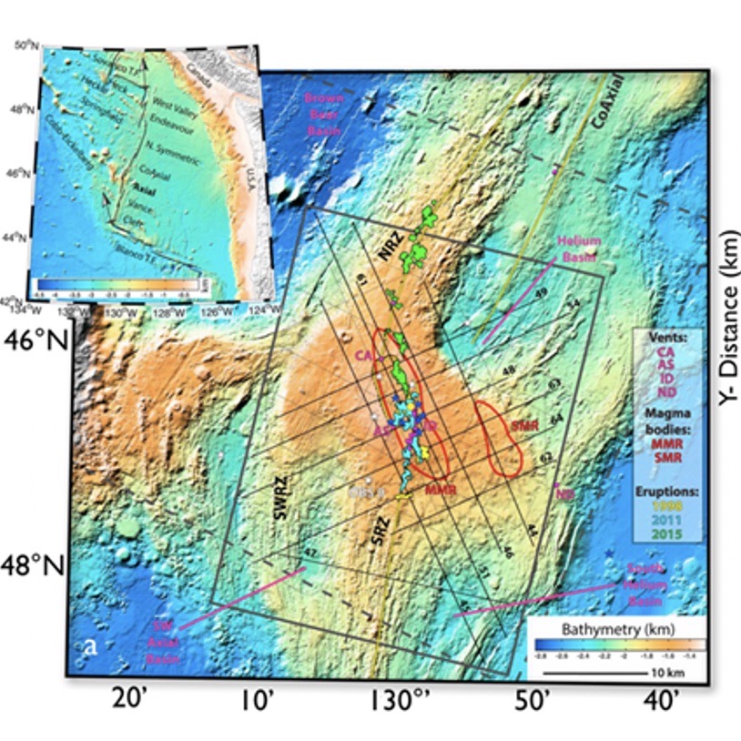
[media-caption type="image" class="external" path="https://oceanobservatories.org/wp-content/uploads/2020/09/Screen-Shot-2020-09-17-at-1.21.46-PM.png" alt="Axial Seamount Roots" link="#"]. Figure 14: a) Location of 1998, 2011, and 2015 lava flows at the summit of Axial Seamount, two magma chambers (re outlines MMR & SMR) and seismic lines (after [1]). b) Map view and perspective view of the MMR magma reservoir, seismicity and fault mechanisms from 10/2014 to 9/2015 (after [1]).[/media-caption]Two- and 3D-imaging of Axial Seamount, coupled with real-time monitoring of seismicity and seafloor deformation, is providing unprecedented insights into submarine volcanism, the nature of melt transport, and caldera dynamics (Figure 14) [1-15]. Recently acquired 3D imaging of the volcano [2] and analyses of 1999 and 2002 multichannel seismic data [4-7] have led to the remarkable discovery of a root zone 6 km beneath the volcano [2,5]. Carbotte et al., [5] describe a 3-to-5 km wide conduit that is interpreted to be comprised of numerous quasi-horizontal melt lenses spaced 400-500 m apart. The conduit is located beneath a 14-km-long magma reservoir (MMR) that spans the caldera of Axial Seamount and a secondary, smaller magma chamber (SMR) located beneath the eastern flank of the volcano [1,3]. This smaller reservoir presumably Dymond hydrothermal field hosting up to 60 m-tall actively venting chimneys, which was discovered on a 2011 RCA cruise. Seismicity prior to, during and subsequent to the 2015 eruption delineates outward dipping normal faults in the southern half of the caldera that extend from near the seafloor to 3-3.25 km depth [3,8-9]. In contrast, a conjugate set of inward dipping faults in the northern portion of the caldera extend to depths of ~ 2.25 km. The outward dipping ring faults were active during inflation and syn-eruptive deformation [[3,8-9]. Source fissures for the 1998, 2011, and 2015 eruptions are located within ± 1 km of where the MMR roof is shallowest (<1.6 km beneath the seafloor) and skewed toward the eastern caldera wall [3]. In concert, these studies are changing long-held views of magma chamber geometry and the deep-rooted feeder systems in mid-ocean ridge environments [2,5].
[1] Arnulf, A. F., Harding, A. J., Kent, G. M., Carbotte, S. M., Canales, J. P., and Nedimovic, M. R. (2014) Anatomy of an active submarine volcano. Geology, 42(8), 655–658. https://doi.org/10.1130/G35629.1.
[2] Arnulf, A.F., Harding, A.J., Saustrup, S., Kell, A.M., Kent, G.M., Carbott, S.M., Canales, J.P., Nedimovic, M.R., Bellucci M., Brandt, S., Cap, A., Eischen, T.E., Goulin, M., Griffiths, M., Lee, M., Lucas, V., Mitchell, S.J., and Oller, B. (2019) Imaging the internal workings of Axial Seamount on the Juan de Fuca Ridge. American Geophysical Union, Fall Meeting 2019, OS51B-1483.
[3] Arnulf, A.F., Harding, A.J., Kent, G.M., and Wilcock, W.S.D. (2018) Structure, seismicity and accretionary processes at the hot-spot influenced Axial Seamount on the Juan de Fuca Ridge. Journal of Geophysical Research, 10.1029/2017JB015131.
[4] Carbotte, S. M., Nedimovic, M. R., Canales, J. P., Kent, G. M., Harding, A. J., and Marjanovic, M. (2008) Variable crustal structure along the Juan de Fuca Ridge: Influence of on-axis hot spots and absolute plate motions. Geochemistry, Geophysics, Geosystems, 9, Q08001. doi.org/10.1029/2007GC001922.
[5] Carbotte, S.M., Arnulf, A.F., Spiegelman, M.W., Harding, A.J., Kent, G.M., Canales, J.P., and Nedimovic, M.R. (2019) Seismic images of a deep melt-mush feeder conduit beneath Axial Volcano. American Geophysical Union, Fall Meeting 2019, OS51B-1484.
[6] West, M., Menke, W., and Tolstoy, M. (2003) Focused magma supply at the intersection of the Cobb hotspot and the Juan de Fuca ridge. Geophysical Research Letters, 30(14), 1724. https://doi.org/10.1029/2003GL017104.
[7] West, M., Menke, W., Tolstoy, M., Webb, S., and Sohn, R. (2001). Magma storage beneath Axial volcano on the Juan de Fuca mid-ocean ridge. Nature, 413(6858), 833–836. doi.org/10.1038/35101581.
[8] Wilcock, W.S.D., Tolstoy, M., Waldhauser, F., Garcia, C., Tan, Y.J., Bohnenstiehl, D.R., Caplan-Auerbach, J., Dziak, R., Arnulf, A.F., and Mann, M.E. (2016) Seismic constraints on caldera dynamics from the 2015 Axial Seamount eruption. Science, 354, 1395-399; https://doi.org/10.1126 /science.aah5563.
[9] Wilcock, W.S.D., Dziak, R.P., Tolstoy, M., Chadwick, W.W., Jr., Nooner, S.L., Bohnenstiehl, D.R., Caplan-Auerbach, J., Waldhauser, F., Arnulf, A.F., Baillard, C., Lau, T., Haxel, J.H., Tan, Y.J, Garcia, C., Levy, S., and Mann, M.E. (2018) The recent volcanic history of Axial Seamount: Geophysical insights into past eruption dynamics with an eye toward enhanced observations of future eruptions. Oceanography, 31,(1), 114-123.
[10] Chadwick, W.W., Jr., Nooner, S.L., and Lau, T.K.A. (2019) Forecasting the next eruption at Axial Seamount based on an inflation-predictable pattern of deformation. American Geophysical Union, Fall Meeting 2019, OS51B-1489.
[11] Chadwick, W.W., Jr., Paduan, J.B., Clague, D.A., Dreyer, B.M., Merle, S.G. Bobbitt, A.M. Bobbitt, Caress, D.W. Caress, Philip, B.T., Kelley, D.S., and Nooner, S. (2016) Voluminous eruption from a zoned magma body after an increase in supply rate at Axial Seamount. Geophysical Research Letters, 43, 12,063-12,070; https://doi. org/10.1002/2016GL071327.
[12] Nooner, S.L., and Chadwick, W.W. Jr. (2016) Inflation- predictable behavior and co-eruption deformation at Axial Seamount. Science, 354, 1399-1403; https://doi.org/10.1126/ science.aah4666.
[13] Nooner, S.L., and Chadwick, W.W. Jr. (2016) Inflation- predictable behavior and co-eruption deformation at Axial Seamount. Science, 354, 1399-1403; https://doi.org/10.1126/ science.aah4666.
[14] Hefner, W.L., Nooner, S.L., Chadwick, W.W., Jr., and Bohnenstiehl, D.R. (2020) Magmatic deformation models including caldera-ring faulting for the 2015 eruption of Axial Seamount. Journal of Geophysical Research, https://doi:10.1029/2020JB019356.
[15] Levy, S., Bohnenstiehl, D.R., Sprinkle, R., Boettcher, M.S., Wilcock, W.S.D., Tolstoy, M., and Waldhouser, F. (2018) Mechanics of fault reactivation before, during, and after the 2015 eruption of Axial Seamount. Geology, 46(5), 447-450; https://doi.org/10.1130/G39978.1.
Read More
Mission Complete: 23 Days at Sea
By Darlene Trew Crist and Debbie Kelley
23 days at sea.1200 miles of transit. 44 ROV Jason Dives. Over 80,000 lbs of equipment mobilized. Turned, deployed or recovered 225 pieces of infrastructure on the seafloor and in the water column. More than 500 hours of continuous livestreaming video from ship to shore through a satellite 22,000 miles overhead, and daily updates of cruise activities.
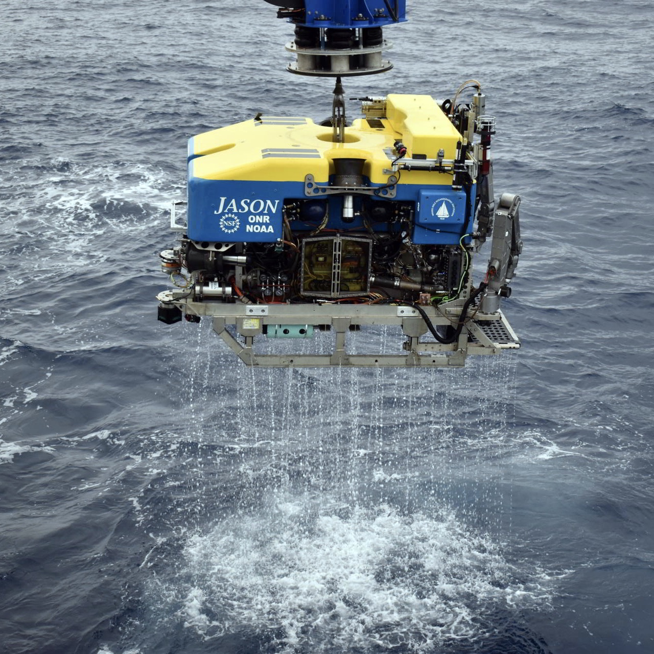
These numbers provide only a glimpse of what was accomplished by a team of scientists and engineers from the University of Washington (UW), pilots of the ROV Jason from Woods Hole Oceanographic Institution, and the captain and the crew of the R/V Thomas G. Thompson, during a nearly month-long expedition in the northeast Pacific Ocean to maintain OOI’s Regional Cabled Array (RCA), operated and maintained by UW. After a mandatory two-week quarantine, the scientific party departed aboard the R/V Thompson from Newport, Oregon on 1 August to begin the journey to replace and install equipment on the array. The ship returned to Newport on 13 August to offload the recovered equipment and load a new supply for the second Leg, which left on 15 August, finally returning to port on 26 August.
Funded by the National Science Foundation (NSF), the cruise was highly complex, involving a diverse array of ~109 Core instruments, three junction boxes, two Benthic Experiment Platforms, six instrumented pods on the Shallow Profiler Moorings, which were recovered and installed, and three Deep Profiler vehicles, which were turned. In addition, six instruments conducting scientific experiments for principal investigators external to OOI were recovered, one was installed and another turned.
While the overall mission was clear, the cruise plan remained flexible to allow the Chief Scientists to modify operations, as needed, depending upon weather conditions. The expedition traveled to all of the RCA sites — Slope Base, Oregon Offshore, Oregon Shelf, Southern Hydrate Ridge, and Axial Base and Axial Caldera, with multiple 22-hour transits to Axial Seamount.
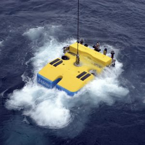
[media-caption type="image" class="external" path="https://oceanobservatories.org/wp-content/uploads/2020/09/Regional-Cabled-Array.-.jpg" alt="Regional Cabled Array" link="#"]Location of RCA infrastructure showing installed backbone cable (solid lines), extension opportunities (dashed lines) Primary Nodes (red boxes), cabled moorings (green dots), and Endurance uncabled moorings (yellow dots). Credit: University of Washington.[/media-caption]All Objectives Completed on Leg One
All instrument and platform installations scheduled for Leg 1 were completed by mid-day on 12 August during 26 dives. Six instrumented platforms on the Shallow Profiler Moorings and three instrumented Deep Profiler vehicles were turned, two junction boxes and over 80 instruments recovered and reinstalled.
Taking advantage of the good weather and the early completion of anticipated tasks, the RCA team transited to the Endurance Shelf site (80 meters), where they recovered several cabled platforms and instruments that were planned for Leg 2 of the expedition. Again, taking advantage of ideal visibility at the seafloor there, the RCA team performed three Jason dives, successfully recovering the Zooplankton Sonar, the Benthic Experiment Package (BEP), and a digital still camera.
After the completion of these dives, the R/V Thomas G.Thompson headed back to shore. The ship arrived at the NOAA Marine Operations Center-Pacific dock in Newport, Oregon on 13 August and began mobilization/demobilization for the changeover from Leg 1 to Leg 2 of the cruise.
[media-caption type="image" class="external" path="https://oceanobservatories.org/wp-content/uploads/2020/09/Combined-picture-RCA.jpg" alt="Combined picture" link="#"]Deploying the new Deep Profiler vehicle at Slope Base on 11 August (left) Credit: M. Elend, University of Washington, V20.; Recovering the Benthic Experiment Package (BEP) at the Endurance Shelf site (right): Credit: UW/NSF-OOI/WHOI.V20.[/media-caption] [media-caption type="image" class="external" path="https://oceanobservatories.org/wp-content/uploads/2020/09/Combined-2.jpg" alt="Combined 2" link="#"]R/V Thomas G. Thompson, Leg 1 Demobilization / Leg 2 Mobilization of two BEPs, a Zooplankton sonar platform, and platforms to be installed at Axial Seamount Credit: University of Washington, V20.[/media-caption]Weather Challenges on Leg Two
The ship departed from Newport again on 15 August and headed to the Endurance Array Oregon Shelf site to resume maintenance operations. There, the team deployed the cabled Zooplankton Sonar, however, installation of the BEP, which weighs over 3,000 lbs and is latched underneath Jason for installation and recovery, was postponed due to large swells.
The ship next transited over 300 miles offshore to Axial Seamount to complete the maintenance activities there. When the Thompson arrived at Axial, it successfully turned a secondary node at the Eastern Caldera site that provides power and bandwidth to a geophysical suite of instruments and now hosts a new CTD funded by NSF to Dr. W. Chadwick (one of three instruments for installation on the RCA as part of this award). It was a notable event because the junction box had been deployed on 22 July 2013 and had spent the last 2,583 days or 7.1 years in 1516 meters of water within Axial Caldera!
For the next eight days, cruise operations proceeded smoothly with intermittent weather delays. Even though weather was not completely cooperative, the team was able to complete a total of 14 dives during which they turned a BEP, two digital still cameras, two uncabled seafloor instruments, and a CTD. They also recovered three cabled instruments and an uncabled instrumented platform for principal investigators conducting research at Southern Hydrate Ridge. One dive was dedicated to an inspection and troubleshooting of Primary Node PN1B, which was offline.
Later in the cruise, weather put onboard activities on hold, however, a cohort of enthusiastic students onshore (due to COVID) virtually ‘visited’ the ship and Jason operations van as part of the NSF-funded STEMSEAS program, which provides at-sea experiences for undergraduates. The students had the opportunity to interact with Chief Scientist Brendan Philip, who completed his oceanography undergraduate and masters’ degree at the University of Washington, as well as a visit with two UW and Queens College undergraduate students sailing onboard as science aides as part of the UW VISIONS experiential learning program. They were also introduced to RCA engineers and members of the Jason team inside the control van.
[media-caption type="image" class="external" path="https://oceanobservatories.org/wp-content/uploads/2020/09/Katie_Steve_sm.Newport_20200815_111023_L2_start-copy-2-scaled.jpg" alt="Katie_Steve" link="#"]K. Gonzalez, UW Oceanography undergraduate, and S. Karaduzovic, Queens College undergraduate, gaze out into the NE Pacific as the R/V Thomas G. Thompson sails through the Yaquina Bay channel on its way to begin Leg 2 of the RCA expedition. Credit. M. Elend, University of Washington. V20.[/media-caption] [media-caption type="image" class="external" path="https://oceanobservatories.org/wp-content/uploads/2020/09/J1267_20200809_155656_THSPHA301_deploy-copy.jpg" alt="Screen" link="#"]Video, sonar, and navigation panels inside the ROV Jason control van as the team works nearly a mile beneath the oceans’ surface at the International District Hydrothermal Field atop Axial Seamount. Credit: University of Washington. V20.[/media-caption]With lessening swell heights, the team completed RCA maintenance tasks at Southern Hydrate Ridge. Additional efforts were focused on the recovery of a cabled multi-beam sonar and a 4K camera funded by Germany to Drs. Y. Marcon and G. Bohrmann, Bremen University, to quantify methane flux and turning of a CTD. In addition, a methane microbial fuel cell platform was recovered as part of an Office of Naval Research (ONR)-funded project to Dr. C. Reimers (Oregon State University)—sailing as a member of the Leg 2 shipboard party. Upon completion of instrumentation work at Southern Hydrate Ridge, the Thompson transited back to the Endurance Array Oregon Shelf site to complete the remaining maintenance task, the deployment of the cabled BEP.
During the latter part of the cruise, weather again impacted what the team was able to do, but the science team continued to improvise to utilize ship time as efficiently as possible. For example, when winds (>20 knots) and large swells in the Shelf Area prevented the team from deploying the final (heavy) BEP, Dr. Reimers used some of her remaining ONR-supported at-sea time to conduct a Jason dive in the region of the West Coast Rockfish Conservation Area to survey fish, invertebrates, seeps, and trawl marks along a downslope transect. These data will be useful for collaborative work between Oregon State University and the Oregon Department of Fish and Wildlife scientists in decision-making about the reopening of the region in 2020, after 19 years of being closed to bottom trawling.
When the weather cleared, the team performed its final maintenance task of the cruise. They deployed the cabled Shelf BEP in 80 meters of water, after which the ship headed back to Newport to reunite with friends and family after six weeks away. The expedition ended having met all objectives, in spite of the weather.
Unique Views of the Seafloor
The RCA expedition literally offered a “bird’s eye view” of seafloor life. Below is a collection of some of the activities conducted and life witnessed on the seafloor.
Crab-infested Primary Node
[media-caption type="image" class="external" path="https://oceanobservatories.org/wp-content/uploads/2020/09/News_Crabs_PN1B-use-sulis2_20200818202445--scaled.jpg" alt="News_Crabs" link="#"]The ROVJason inspects Primary Node PN1B. These 12,000 lb nodes and primary backbone cable were built and installed in 2014 through an award to L3MariPro. This large seafloor substation converts 10,000 volts to 374 volts, and 10 Gb/s bandwidth to be distributed to cabled platforms and instruments. Here, extension cables plugged inside the node with wet-mate connectors provide power and bandwidth to Southern Hydrate Ridge, and upstream to the Oregon Offshore and Shelf sites. Credit: UW/NSF-OOI/WHOI. V20.[/media-caption]Octopus Abound
[media-caption type="image" class="external" path="https://oceanobservatories.org/wp-content/uploads/2020/09/Octopus-on-the-seafloor.jpg" alt="Octopus on the seafloor" link="#"]Octopus on the seafloor at Endurance Array Oregon Offshore Site. Credit: UW/NSF-OOI/WHOI. V20.[/media-caption]Islands of Sea Life
[media-caption type="image" class="external" path="https://oceanobservatories.org/wp-content/uploads/2020/09/news_SHllow-Profier_Offshore_20200803_133613180.framegrab03-copy.jpg" alt="Shallow_Profiler" link="#"]The ROV Jason installs a refurbished instrumented platform onto the Shallow Profiler Mooring at the cabled Oregon Offshore site. The platform hosts a zooplankton sonar, and instruments that measure pH, dissolved CO2, salinity, temperature, and dissolved oxygen. The 12 ft-across large mooring platforms at 200 m depth stay in the water for several years and become islands inhabited by a wealth of sea life. Credit: UW/NSF-OOI/WHOI.V20.[/media-caption]Big Red
[media-caption type="image" class="external" path="https://oceanobservatories.org/wp-content/uploads/2020/09/Big_Red_Jelly_sm.sulis2_20200817205124-copy-2-scaled.jpg" alt="Big Red Jellyfish" link="#"]A “Big Red” jellyfish swam past the ROV Jason 68 miles offshore of Oregon. Credit; UW/NSF-OOI/WHOI.V20.[/media-caption]Methane Seeps
[media-caption type="image" class="external" path="https://oceanobservatories.org/wp-content/uploads/2020/09/News_Abundant-Life-SHR_good_sulis2_20200826014741-copy-2-scaled.jpg" alt="Abundant_Sea_Life" link="#"]The Regional Cabled Array team always enjoys dives to the methane seep site at the Southern Hydrate Ridge. It is rich in animals — e.g. red striped rockfish, lavender hagfish, crabs, spotted sole — that thrive among the carbonate blocks and adjacent to the seeps where methane streams from the seafloor. Credit: UW/NSF-OOI/WHOI.V20.[/media-caption]Axial Seamount Summit
[media-caption type="image" class="external" path="https://oceanobservatories.org/wp-content/uploads/2020/09/News_use_J2-1277_Great-Crab-collapse_sulis2_20200817132525-copy-scaled.jpg" alt="Spider Crab" link="#"]A spider crab explores a collapsed, frozen lava lake at the summit of Axial Seamount, an active underwater volcano 4970 ft beneath the oceans’ surface, which is poised to soon erupt. Credit: UW/NSF-OOI/WHOI.V20.[/media-caption]
Read More
Axial Seamount: One of the Longest Records for Tsunami Research in the Ocean
Adapted and condensed by OOI from Fine et al., 2020, doi:/10.1029/2020GL087372.
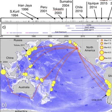
[caption id="attachment_18951" align="aligncenter" width="794"] Figure 22. a) Location of bottom pressure recorders (BPRS) at Axial Seamount and vicinity (Cleft segment not shown in this illustration), including DART buoys and an IODP Corked site (after [1]). Most of the pressure data for this investigation were from Axial Seamount. b) Source regionals for the tsunamis recorded at Axial with yellow circles indicating earthquake locations and circle size proportional to magnitudes. The thin blue lines mark the leading edge of tsunamis at 2 hr intervals after an earthquake. c) Temporal coverage of the BPR records and recorded tsunamis at Axial and adjacent areas 1986-2018. Magenta lines are BPR recordings from the Cleft Segment, south of Axial on the Juan de Fuca Ridge.[/caption]This study by Fine et al., [1] examines a 32 year record of high resolution bottom pressure recorder (BPR) measurements made by cabled instruments installed on Axial Seamount in 2014, and uncabled instruments at Axial, the Cleft Segment of the Juan de Fuca Ridge, DART buoys, and an IODP cored observatory (Hole 1026): most of the measurements in this study are from Axial (Figure 22). A total of 41 tsunamis were documented from 1986-2018 with all events associated with tsunamigenic earthquakes with magnitudes of 7.0 or greater. In contrast to coastal tide gauge observations, open ocean measurements by BPRs are advantageous because of the high signal-to-noise ratio. Based on this study, it is possible to forecast the effect of a tsunami originating from a source near a historical source, not only for Axial, but also for locations along the British Columbia‐Washington‐Oregon coast. These results allow a size-frequency model world-wide. The RCA cabled bottom pressure-tilt instruments, with 20 Hz sampling rates and with resolutions of 2 mm of seawater depth, provide especially high-resolution measurements.
[1] Fine, I.V., Thomson, R.E., Chadwick, W.W., Jr., and Fox, C.G., (2020) Toward a universal frequency occurrence distribution for tsunamis: statistical analyses of a 32-year bottom pressure record at Axial Seamount. Geophysical Research Letter, https://doi.org/10.1029/2020GL087372.
Read More
Live Video from Regional Cabled Array Expedition
Don’t miss this rare opportunity to participate in a research cruise from aboard the ship and below the surface. Live video is being broadcast from the Regional Cabled Array’s eighth Operations and Maintenance expedition aboard the R/V Thomas G. Thompson. It is really an extraordinary way to watch first-hand the complexity of the operation involved in keeping a network of 900 kilometers of electro-optical cables supplying unprecedented power, bandwidth (10 Gigabit Ethernet, and two-way communication to scientific sensors on the seafloor and throughout the water column, so data are continuously collected and research conducted. Bookmark these links and tune in often!
Streaming live video from the ship and from the ROV ROPOS.
Credit: NSF-OOI/UW/CSSF.[/caption]
Read More
Live Video from Regional Cabled Array Expedition
For the month of August, you can be a scientist aboard the R/V Thomas G. Thompson Regional Cabled Array expedition and explore the ocean floor and biologically-rich waters of the northeastern Pacific Ocean in real-time. A livestream is being broadcast of onboard activities and from the ROV, as it recovers and deploys instrumentation to maintain the Regional Cabled Array. Bookmark this livestream link and during August you can experience life and science at sea.
Please note: The livestream video is transmitted from the ship to a satellite, then to shore. Occasionally, the land-based down-link system goes down and depending on the ship’s heading, there may be an intermittent pause in the satellite connection. If the screen is blank or you see an error code, please check back soon as the connection should refresh shortly.
Read More
RCA Embarks on a Month of Discovery in August
The University of Washington (UW) Regional Cabled Array (RCA) team entered a two-week quarantine period on 16 July before heading out to sea August 1, aboard the UW global class research ship the R/V Thomas G. Thompson for a month-long expedition in the northeastern Pacific. The expedition is funded by the National Science Foundation as part of the Ocean Observatories Initiative. The team will need whatever rest they can muster during the quarantine, as the expedition promises to be replete with round-the-clock activity, including multiple dives a day by the remotely operated vehicle (ROV) Jason.
During this expedition, the team will recover and reinstall more than 200 instruments with the ROV, while broadcasting livestream video from the ROV Jason to the ship, to a satellite over 22,000 miles above the Earth. From space, the video will then be transmitted to the UW, where it will be publicly available on the UW InteractiveOceans website. A daily blog will provide updates on the expeditions progress. Throughout the month, viewers will witness life thriving at depths 2900 m (>9500 ft) beneath the ocean surface and at Axial Seamount, the most active submarine volcano off the coast of Oregon and Washington.
[media-caption type="image" path="https://oceanobservatories.org/wp-content/uploads/2020/07/Control-room-_Jason_Hell_-Vent-scaled.jpg" link="#"] An example of some of the stunning imagery that will be live-streamed during the RCA expedition. Credit: Ramya Ravichandran Asha, UW, V19.[/media-caption]The RCA consists of 900 kilometers of cable that provide high-power, bandwidth, and two-way communication to 150 scientific instruments on the seafloor and to state-of-the art instrumented moorings that relay a constant stream of real-time ocean data to shore, 24 hours 365 days a year. All data are freely available to the community.
Being in corrosive saltwater for a 12-month stint is a hostile environment for equipment, so every summer a team of UW scientists and engineers head out to the array to recover equipment and deploy replacement ocean observing instrumentation These recovery and redeployment missions ensure that data continuously flow to shore from this Internet-connected array. At the RCA, cabled instruments are located across the Cascadia Margin, the Southern Hydrate Ridge, and at Axial seamount, each making an important contribution to better understanding the subseafloor environment. Cascadia Margin is one of the most biologically productive areas in the global ocean. Explosions of methane-rich bubbles issuing from beneath the seafloor rise > 1000 feet into the overlying water column at Southern Hydrate Ridge. Axial seamount has erupted in 1998, 2011, and 2015 and hosts some of the most extreme environments on Earth—underwater hot springs venting fluids at >700°C.
Dr. Orest Kawka, an RCA Senior Research Scientist, and Brendan Philip from the UW will sail as Chief Scientists – directing the cruise during the four weeks at sea. As an undergraduate, Philip sailed on numerous RCA cruises as part of the UW educational VISIONS at sea experiential learning program, which has taken over 160 undergraduate students to sea, and later as a member of the RCA team. He is now pursuing a master’s degree in Technology, Science, and Policy at George Washington University in Washington, DC.
Because of the large amount of gear (over 80,000 pounds of equipment) to load onto the fantail of the Thompson for deployment, the cruise will consist of two legs.
[media-caption type="image" path="https://oceanobservatories.org/wp-content/uploads/2020/07/RCA-Jason-manipulator-with-sea-anemones.jpg" link="#"]The manipulator arm of the ROV Jason operates in front of an anemone-covered junction box in the highly productive waters at the Oregon Shelf site. Credit: UW/OOI-NSF/WHOI, V19.[/media-caption]During more than 30 Jason missions to the deep, viewers will witness parts of the ocean rarely seen by humans. The team hopes to revisit some of the scientific highlights of last year’s expedition. One such highlight was Jason being investigated by a swarm of large sable fish. At another site at 80 meters, a junction box became an island completely encrusted in beautiful sea anemones. At Southern Hydrate Ridge, the team saw rarely seen exposed methane hydrate and a moonscape topography dramatically changed from the year before, marked by new explosion pits and collapsed areas. And, on many past expeditions, team members have seen a novel prehistoric-looking fish, which was first filmed in the ocean on the 2014 RCA cruise at the Slope Base site at a depth of 9500 ft. The RCA team fondly refers to this creature as “the weird fish,” (Genioliparis ferox), which also has been documented off Antarctica.
“We’ve got a fantastic team sailing this year, who have been putting in an incredible amount of work for months to get us ready. But like all cruises sailing this year, we’re dealing with the necessary challenge of having a smaller science party and still making sure we can safely accomplish the science and recovery and deployments. We will be in constant communication with the rest of the team back on shore, who will contribute as much to getting our work done as will the science party on the ship. The RCA team is grateful for the opportunity to sail during what has turned out to be a challenging year for ocean science and we’re looking forward to helping other oceanographers continue their research, even if they’re unable to sail this year,” said Chief Scientist Brendan Philip.
[media-caption type="image" path="https://oceanobservatories.org/wp-content/uploads/2020/07/FACT_Cage-scaled.jpg" link="#"]Manipulators on the ROV Jason work on a small frame located ~ 200 m beneath the oceans’s surface, which is encrusted in beautiful feathery creatures called crinoids. Credit: UW/NSF-OOI/WHOI[/media-caption]The Daily Grind
The daily schedule aboard the R/V Thompson promises to be intense, exacerbated by a smaller than normal scientific party due to COVID-19 precautions. “Science teams, when using Jason, tend to keep the vehicle down for a long time, but because the tempo of this cruise is more like an industry cruise, the team will be diving and recovering the vehicle as rapidly as safely possible, sometimes with only a couple hours on deck between dives. It can be exhausting work, particularly for a team that will be onboard for a month,” explained Deb Kelley, RCA Director and principal investigator. “But, being out at sea, seeing the sites and miles of ocean reaching the horizon, and working on this state-of-the-art marine facility makes it all worthwhile.” This year, for the first time, Kelley will be intently observing operations from onshore through the live video stream.
COVID Prevention
A reality in the new COVID-19 world is that the team can only mobilize gear onboard the ship after completing a strict quarantine period. Two weeks prior to boarding, members of the scientific party have lived in their homes (with all family members in quarantine for the duration), hotels or Airbnbs. Team members were tested for COVID prior to entering quarantine and conducted twice day temperature checks during their quarantine. Testing occurred again before being allowed to board the Thompson.
This expedition is novel in another way as a result of COVID precautions. Only two students will be onboard. Prior cruises have had 8-10 VISIONS students on each leg to help out and experience firsthand what it’s like to go to sea. “We are hoping that many students and others tune in to experience this amazing environment that Jason will be revealing over the next month. It’s really an opportunity to visit some of the most extreme environments on Earth and see incredible life forms that has adapted to these harsh environments, which may be particularly uplifting to our spirits now that many folks are stuck at home,” said Kelley.
Livestreaming video will be available here and at InteractiveOceans.
Read MoreAltered Carbon: Improvement to CO2 Measurements Enhance OOI Data Quality
Global carbon dioxide (CO2) concentrations are increasing in the atmosphere, largely due to the use of fossil fuels. The oceans are absorbing about 25-30 percent of the atmospheric CO2, resulting in a shift in seawater acid-base chemistry and a decrease in ocean pH, making seawater more acidic. To help scientists assess this changing ocean chemistry, the Ocean Observatories Initiative (OOI) uses the Sunburst SAMI-CO2 instrument to measure the partial pressure of carbon dioxide (pCO2) from 150-700 microatmospheres (μatm) in the upper 200 meters of the water column.
The distribution of pCO2 in seawater is dependent on gas exchange with the atmosphere at the ocean surface, the breakdown of plant material by microbial processes, and removal by photosynthesis, calcium carbonate formation, and rising temperatures. Increases in pCO2 can also be caused by dissolution of calcium carbonate, which is of particular importance because calcium carbonate minerals are the building blocks for the skeletons and shells of many marine organisms, such as oysters.
Using the SAMI-CO2 instrument, OOI researchers determine the partial pressure of CO2 by equilibrating a pH sensitive indicator solution (Bromothymol Blue) to sampled seawater. Aqueous carbon dioxide in seawater diffuses across a permeable silicone membrane equilibrator within the instrument, which changes the color of the indicator solution from blue to yellow. The equilibrated indicator solution is then pumped through a chamber where light passes through the liquid and into a receptor that uses the wavelength to determine the amount of color change, and thus the amount of CO2 dissolved in the water.
“The OOI system parses the raw data from the instrument, applies a ‘blank’ value to correct for instrument drift, and then delivers calibrated pCO2 data to users on demand,” explained Michael Vardaro, OOI Research Scientist at the University of Washington. “We recently created a fix to apply the correct ’blank’ values to the pCO2 data to improve data accessibility and data quality.”
Blank values (e.g., optical absorbance ratios in the pco2w_b_sami_data_record_cal data stream) are used to calculate the data product “pCO2 Seawater (µatm)” at a specific timestamp. Blank values, however, are recorded intermittently to correct for drift of the electro-optical system, about once a week, which is a longer interval than the instrument sampling rate of one sample per hour.
The recent correction will ensure that any pCO2 data request will use a linearly interpolated value from the closest blanks if no blank value is found within the requested time range. This means that for an hourly pCO2 measurement that falls between weekly blank values the system will calculate the appropriate drift correction to apply based on the surrounding blank values, instead of trying to find a specific blank value that might be outside the date range of the requested data. In addition to improving data quality, this fix prevents the system from returning fill values or empty datasets. Additional restrictions were put on data delivery to prevent interpolation across deployments, which could pull blanks from different instrument serial numbers, potentially creating bad data. These fixes apply to all OOI pCO2 data. Users who have pCO2 data products generated prior to 4 February 2020 are encouraged to re-request their data to ensure that the correct interpolation code is applied.
Any questions about this data fix, or any other OOI data issues, should be directed to help@oceanobservatories.org.
Images
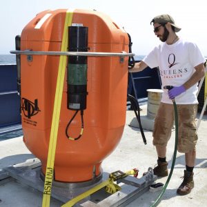
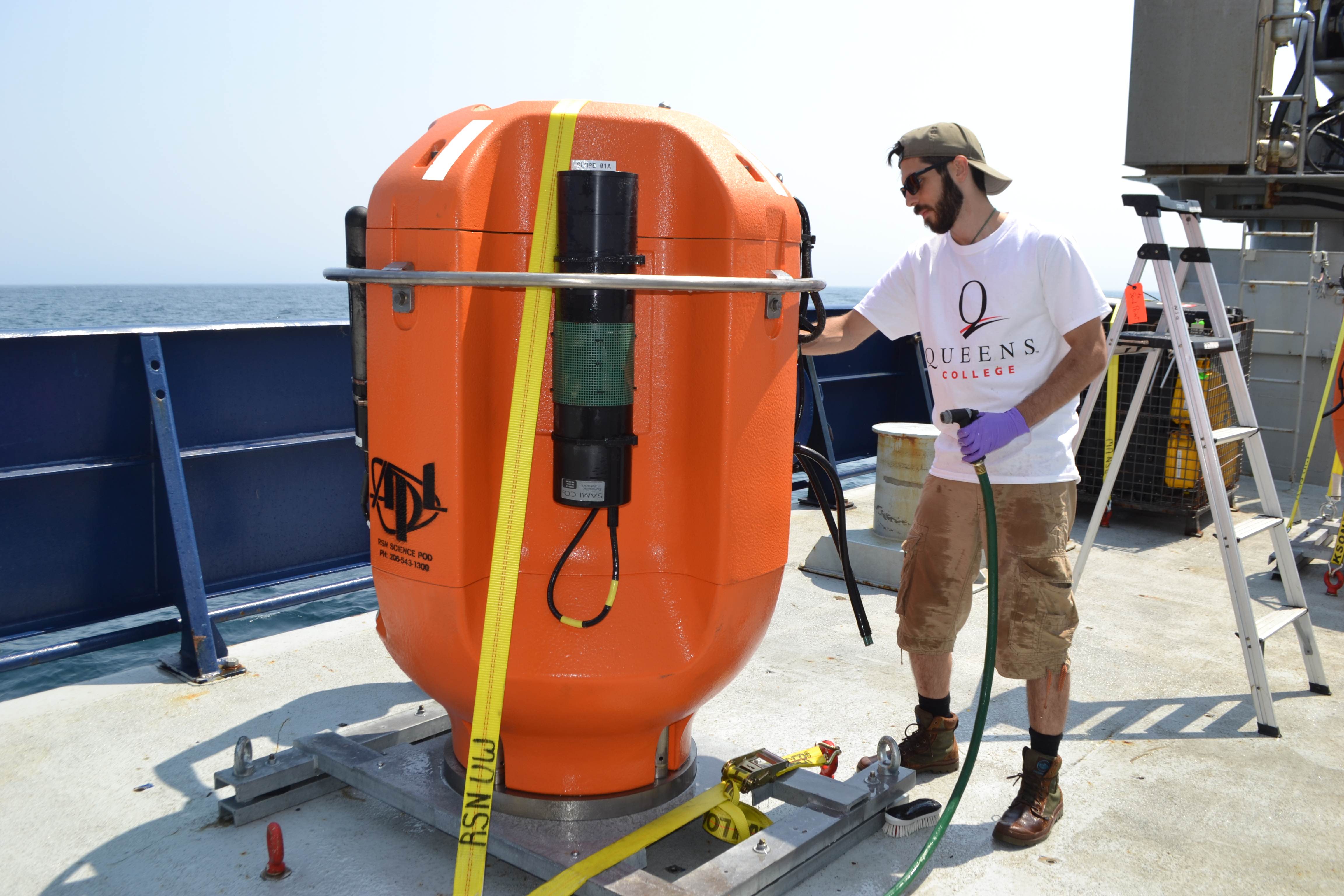
Top: Alex Andronikides, a VISIONS’17 student from Queens College, New York helps clean a Regional Cabled Observatory Shallow Profiler Mooring science pod that was installed off the Washington-Oregon coast. Credit: M. Elend, University of Washington, V17.
Bottom: Pre-deployment photo of a Sunburst SAMI-CO2 sensor attached to the Oregon Offshore Cabled Shallow Profiler pod, which moves up and down in the water column between 200 meters and near the surface off the coast of Newport, OR. Credit: M. Elend, University of Washington, V19.
Read MoreFrom Whale Songs to Volcanic Eruptions: OOI’s Cable Hears the Sounds of the Ocean
Sound is omnipresent in the ocean. Human-induced noise has the potential to affect marine life.
After the global recession in 2008, the ocean became quieter as shipping declined. Off the coast of Southern California, for example, scientists at Scripps Institution of Oceanography found that noise amplitudes measured from 2007-2010 were lowered by 70 percent with a reduction in one ship contributing about 10 percent.
A similar quieting of the ocean can be expected as global ship traffic continues its decline in response to the corona virus pandemic. This quieter ocean offers scientists ways to expand their ongoing research on ocean sound and its impact on marine life.
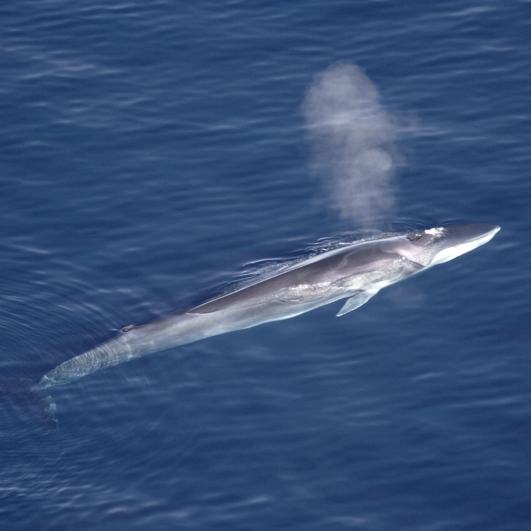
[media type="image" path="https://oceanobservatories.org/wp-content/uploads/2020/04/Finhval_1.jpg" link="#" alt="Fin Whale"][/media]“It takes time to document real change in the ocean, but University of Washington oceanographers have reported that over the past decade, fin whales have been communicating more softly in the Pacific,“ said Deborah Kelley, professor of oceanography at the University of Washington and director of the OOI’s Regional Cabled Array (RCA) component. “A quieter ocean allows us to hear more clearly life and other natural processes within the ocean.”
Years of listening to whales
John Ryan, a biological oceanographer at the Monterey Bay Aquarium Research Institute (MBARI), has been “listening in” on whales and other marine creatures since 2015 using a hydrophone on the Monterey Accelerated Research System (MARS), a cabled observatory, which was in part established as a test bed for the OOI Regional Cabled Array. Ryan and colleagues studied the occurrence of humpback whale (Megaptera novaeangliae) song in the northeast Pacific using three years of continuous recordings off the coast of central California.
[media type="image" path="https://oceanobservatories.org/wp-content/uploads/2020/04/Humpback_Whale_underwater_shot.jpg" link="#" alt="Humpback Whale"][/media]“We’ve been listening almost continuously since July 28, 2015, using a broadband, digital, omnidirectional hydrophone connected to MARS. Listening continuously for that long at such a high sample rate is not easy; only by being connected to the cable is this possible,” explained Ryan.
The researchers were able to discern whale songs from the busy ocean soundscape in Monterey Bay National Marine Sanctuary, which is a feeding and migratory habitat for humpback whales. The humpbacks’ song was detectable for nine months of the year (September–May) and peaked during the winter months of November through January. The study revealed strong relationships between year-to-year changes in the levels of song occurrence and ecosystem conditions that influence foraging ecology. The lowest song occurrence coincided with anomalous warm ocean temperatures, low abundances of krill – a primary food resource for humpback whales, and an extremely toxic harmful algal bloom that affected whales and other marine mammals in the region. Song occurrence increased with increasingly favorable foraging conditions in subsequent years.
Because the hydrophone is on the cabled observatory, its operation can be adjusted to achieve new goals. For example, the sampling rate of the hydrophone was doubled during an experiment that successfully detected very high frequency echolocation clicks of dwarf sperm whales (with Karlina Merkens, National Oceanic and Atmospheric Administration). “And that’s a beautiful aspect of being on the cable,” added Ryan. “Not only do we know that it is working, we catch any network glitches pretty quickly so we don’t lose data, and we can do real-time experiments like these.”
William Wilcock of the University of Washington and his students have compiled a decade worth of data on fin whales in the northern Pacific. Fin whales call at about 20 HZ, which is too low of a frequency for humans to hear, but perfect for seismometers to record. The researchers aggregated ten years of data from both temporary recorders and now permanent RCA hydrophones and seismic sensors and looked at the frequency of the calls and calling intervals. The researchers found both have changed over time.
The fin whales call seasonally and the frequency of the calls has gone down with time.
[audio mp3="https://oceanobservatories.org/wp-content/uploads/2020/04/Fin_whale_10x.mp3"][/audio]Calls peak in late fall, early winter in relation to mating season. Gradually through the season the frequency decreases. At the start of the next season, the call frequency jumps up again, but not quite to where it was the year before. Over ten years, the frequency has gone down about 2 HZ, and scientists are puzzled as to why this is occurring. It is unlikely to be due to increasing ship noise, because this lower sound frequency is getting closer to the range of the noise level of container ship propellers, about 6-10 HZ.
In some settings, ship noise is known to affect whale behavior and the permanent network of hydrophones operated by the OOI and Ocean Networks Canada will provide an opportunity to study whether whales are avoiding the shipping lanes to Asia.
Volcanoes also rumble in the deep
Whale sounds are but one of many acoustic signals being recorded and monitored using hydrophones and broadband seismometers. The OOI’s RCA off the Oregon Coast includes 900 kilometers (~560 miles) of submarine fiber-optic cables that provide unprecedented power, bandwidth, and communication to seafloor instrumentation and profiler moorings that span water depths of 2900 m to 5 m beneath the ocean surface. Using a suite of instruments connected to the cable, which continuously stream data in real time, scientists are listening in on the sounds of submarine volcanism, which accounts for more than 80 percent of all volcanism on Earth.
More than 300 miles off the Oregon coast in 1500 meters of water, 20+ cabled seafloor instruments are located at the summit of Axial Seamount, the most active volcano on the Juan de Fuca Ridge, including hydrophones and seismometers, which can also record sounds in the ocean.
“Scientists were able to hear(as acoustic noises traveling through the crust) >8000 earthquakes that marked the start of the Axial eruption in 2015. Coincident with this seismic crisis bottom pressure tilt instruments showed that the seafloor fell about 2.4 meters (~8 feet).
[video width="670" height="384" m4v="https://oceanobservatories.org/wp-content/uploads/2020/04/Axial-seamount-audio-.m4v"][/video]It was a remarkable collaborative event with scientists from across the country witnessing the eruption unfold live,” added Kelley. Such real-time documenting of an eruption in process was possible because of how Axial is wired. It is the only place in the oceans where numerous processes taking place prior to, during, and following a submarine eruption are captured live through data streaming 24/7. William Wilcock, University of Washington, and Scott Nooner, University of North Carolina, Wilmington, and colleagues reported these findings in Science, 2016.
Data collected from the hydrophones at the seamount’s base supported another discovery about Axial, indicating that it explosively erupted in 2015. Hydrophones recorded long-duration diffusive signals traveling through the ocean water consistent with explosion of gas-rich lavas, similar to Hawaiian style fissure eruptions. Follow-on cruises documented ash on some RCA instruments, again indicating the likelihood of explosive events during the 2015 eruption.
“Having the opportunity to listen in while a submarine volcano is active offers a really interesting window into things,” said Jackie Caplan-Auerbach, associate dean at Western Washington University and lead author of a G-cubed article that reported the possible eruptive findings. “While we cannot say with utter certainty that there were explosions at Axial, there’s a lot of evidence that supports this. We know from having listened to other eruptions that this was the same type of sound. It’s distinct, like the hissing sound of a garden hose on at top speed. We also found these really fine particulates, which could only have resulted from an eruption, had collected on one of the instruments at the site.”
[audio wav="https://oceanobservatories.org/wp-content/uploads/2020/04/axial_explosive.wav"][/audio]Added Caplan-Auerbach, “My favorite part of having OOI is it offers an ability for pure discovery. Its real time nature makes it possible to observe and see what happens. And sometimes the planet just hands you a gift that you didn’t expect. Not always being hypothesis driven is a very valuable aspect of science that I hope does not get lost. I’m very appreciative of projects like this that open our eyes into signals that we didn’t know were there.”
More opportunities to expand knowledge about sound and the sea are on the horizon. The US. Navy has funded Shima Abadi, University of Washington, Bothell, for a comprehensive study of sounds recorded by the OOI hydrophones. Stay tuned!
Image credits: Top fin whale: Wikipedia, Aqqa Rosing-Asvid – Visit Greenland. Second from top: humpback whale: Public domain, National Oceanic and Atmospheric Administration.
Read More