
Posts Tagged ‘University of Washington’
2025 OOIFB Summer School on Acoustics: Applications Now Open
The Ocean Observatories Initiative Facility Board (OOIFB), funded by the U.S. National Science Foundation (NSF), is hosting the 2025 Summer School on Acoustics from July 14–18, 2025, at the University of Washington in Seattle, WA.
This five-day, in-person program will provide targeted lectures, hands-on tutorials, and practical exercises using real-world examples and NSF Ocean Observatories Initiative (OOI) data products. Participants will focus on accessing, analyzing, and interpreting acoustic data alongside complementary oceanographic datasets available through OOI.
By the end of the program, participants will have a deeper understanding of underwater sound propagation, passive and active acoustic instruments (e.g., hydrophones and echosounders) deployed through OOI, and the available datasets. They will also learn how to navigate OOI data portals, apply basic acoustic data processing methods, and explore how these data can support scientific research. The program also offers opportunities to connect with a professional network of researchers using OOI data.
There are no registration fees, and travel support is available for participants from U.S. institutions. For details on program requirements, eligibility, a draft agenda, and the application process, visit the OOIFB Summer School on Acoustics webpage.
Please share this opportunity with your colleagues and networks. For questions, contact Holly Morin (holly@ooifb.org).
Read MoreRegional Cabled Array: Monitoring Axial Seamount in Real Time
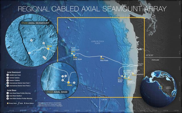
The Regional Cabled Array (RCA) is the world’s most extensive undersea volcano monitoring system, located off the Oregon coast. Operated by the University of Washington as part of the Ocean Observatories Initiative (OOI), the RCA features a network of submarine cables extending 200 miles offshore from Pacific City and Newport. This system monitors the Axial Seamount, a submarine volcano expected to erupt this year.
In a recent interview, Deb Kelley, OOI Principal Investigator and Director at the University of Washington School of Oceanography, discussed how the RCA collects near-time data to track seismic activity, hydrothermal systems, and chemical changes associated with volcanic activity. The RCA’s data supports long-term research on ocean dynamics and tectonic processes, providing critical insights into the Earth’s underwater systems.
Watch the full interview with KPTV FOX 12 here: https://www.youtube.com/watch?v=PUJMTdka8KI
[caption id="attachment_35589" align="alignnone" width="640"] Credit: Center for Environmental Visualization, University of Washington[/caption]
Read More National Science Foundation Renews OOI for Another Five Years
The National Science Foundation (NSF) announced that it has awarded a coalition of academic and oceanographic research organizations a second, five-year contract to operate and maintain the Ocean Observatories Initiative (OOI). The coalition, led by the Woods Hole Oceanographic Institution (WHOI), and including the University of Washington (UW) and Oregon State University (OSU), will continue operations of the OOI, a science-driven ocean observing network that delivers real-time data to address critical science questions regarding the world’s oceans.
WHOI has led the operations and management aspects of the OOI since 2018 and will continue to serve as the home for the next five years of the OOI Project Management Office, led by Principal Investigator James B. Edson and Sr. Program Manager Paul Matthias.
The OOI collects and serves measurements from more than 900 autonomous instruments on the seafloor and on moored and free-swimming platforms that are serviced during regular, ship-based expeditions to the array sites. Data from each instrument are transmitted to shore and are freely available to users worldwide, including scientists, policy experts, decision-makers, educators, and the public.
Under this new $220 M investment, each institution will continue to operate and maintain the portion of OOI assets for which it is currently responsible: WHOI will operate the Pioneer Array in the mid-Atlantic Bight off the North Carolina coast, subject to environmental permitting, and the Global Arrays in the Irminger Sea off the southern tip of Greenland and at Station Papa in the Gulf of Alaska; UW will operate the Regional Cabled Array that extends across the Juan de Fuca tectonic plate and through the overlying ocean; and OSU will operate the Endurance Array off the coast of Washington and Oregon. OSU also houses and operates OOI’s Data Center that ingests and delivers all OOI data.
“OOI has proven to be an exceedingly valuable source of information about the ocean,” said NSF Program Officer for OOI George Voulgaris. “Its freely available data are contributing to better understanding of ocean processes and how the ocean is changing. Scientists are using OOI data as the source of cutting-edge scientific discoveries—everything from getting close to predicting underwater volcanic eruptions to changing ocean circulation patterns that have real life implications for weather and fishing patterns. OOI data also are serving as inspiration for students in the classroom, who are excited about learning about the ocean with access to real-time ocean data. We at NSF are proud of our continued investment in making these data available.”
“WHOI is honored to have been selected to continue the mission of the OOI, which is providing valuable ocean data at a time when it is critically needed,” said Peter de Menocal, President and Director of the Woods Hole Oceanographic Institution. “The continued extreme weather events reinforce the importance of this ocean monitoring program to provide science-based data that is accessible to researchers, modelers, agencies, and the public, and we look forward to being part of the continued scientific advancements from this transformational program in the years ahead.”
The Project Management Office at WHOI collaborates with NSF to provide high-level oversight and financial management of the project. In addition, the office coordinates with partner institutions to establish annual priorities for each of the arrays individually and for the network. “The WHOI team and our partners at UW and OSU have learned a great deal over the past five years and are grateful that our efforts to perfect OOI and its data delivery system have been recognized,” said WHOI Senior Scientist Jim Edson, lead principal investigator on the OOI. “We look forward to the next five years where we can continue to perfect our collection and serving of data, while encouraging its increased use and collaboration among ocean scientists funded by NSF and other agencies.”
——————————————
About the Ocean Observatories Initiative
The Ocean Observatories Initiative is a science-driven ocean observing network that delivers real-time data from more than 900 instruments to address critical science questions regarding the world’s oceans. The National Science Foundation has funded the OOI, under Cooperative Agreement No. 1743430, to encourage scientific investigation. OOI data are freely available online to anyone with an Internet connection.
The U.S. National Science Foundation is an independent federal agency that supports science and engineering in all 50 states and U.S. territories.
Any opinions, findings, and conclusions or recommendations expressed in this material are those of the author(s) and do not necessarily reflect the views of the National Science Foundation.
Read More
UW Students Catalog Visual Treasures from the Undersea World
Watch a squid change color or a spider crab move out of the way of the arm of a Remotely Operated Vehicle (ROV), or have a closeup view as a deep sea skate gracefully swims over the seafloor at Axial Seamount. These are but some of the magical moments captured and cataloged by University of Washington (UW) students who have participated in the UW at-sea experiential learning program associated with the Ocean Observatories Initiative Regional Cabled Array’s (RCA) VISIONS cruises.
[media-caption path="/wp-content/uploads/2022/03/Sponge.png" link="#"]The Poralia rufescens was seen at Slope Base. It was found floating in the water column at 2867 meters. Another one was spotted swimming among the dust kicked up by ROPOS at about 2900 meters. Photo Credit: NSF-OOI/UW/CSSF; Dive 1757; V14.[/media-caption]Since 2014, a team of students has been sorting, cataloging, and making publicly available high-definition video and images captured by underwater cameras on ROVs during RCA expeditions. While the primary work of the ROVs is to recover and deploy ocean observing equipment powered by RCA’s high-power and bandwidth submarine cables that stream data live to the Internet, a side benefit is reams of footage and still images of marine life on and near the seafloor and throughout the water column collected during the ROV dives. As part of their shipboard experience during VISIONS expeditions, students stand daily watches in the ROV control labs, working alongside scientists, engineers, and the ship and ROV teams. The students help catalog and timestamp the video footage streaming live from the ROV back to the ship.
The idea for a publicly available online biology catalog was the brainchild of seven VISIONS’14 students on the cruise that year. They were prompted to develop a community resource by perpetually trying to answer the question in the control room: “What do you think that animal is?”
“The initial idea was to create a repository specific to the cabled array and specific to the sites that we visit each year to help answer that question for students and people on shore,” explained Katie Bigham, who evolved from VISIONS student to co-chief scientist for VISIONS’21 and contributed significantly to the catalog during its inception. “We first started the catalog with images and video from Axial Seamount and it grew from there. And Lottie Gonzalez, who has been on every VISIONS cruise since 2017, was instrumental in the catalog’s expansion from Axial to coastal sites.”
[media-caption path="/wp-content/uploads/2022/03/Cockatoo-Squid.png" link="#"]A cockatoo squid (Galiteuthis phyllura) encountered at 585 meters depth during a site survey between the 2-legged mooring EOM leg anchor and the low-voltage node LV01C at Endurance Oregon Offshore. The squid was red when we first encountered it, and then it turned clear as we took video. Photo Credit: NSF-OOI/UW/CSSF, Dive R1752, V14.[/media-caption]
Lottie Gonzalez was hooked on the catalog from here first time at sea. “I wasn’t really sure where to get information on relevant biology that I was seeing in the ROV control room. I was initially directed by Deb Kelley (RCA’s Principal Investigator and Lead of the VISIONS program) to take a look at the biology catalog. As soon as I saw it, it became my first project.” Gonzalez continually added to and updated the catalog during her summer shipboard experiences with the VISIONS program. Gonzalez has also used the catalog as the foundation for training programs and other educational resources she has developed to help guide other VISIONS students and is continuously looking for ways to streamline and improve it.
With input from VISIONS students and professors, the catalog now contains images and videos of eight taxonomic groups and 61 species, along with descriptions of animals’ feeding habits, behaviors, and environmental ranges. Student curators have always welcomed input from experts to help improve content and validate species identification.
The biology catalog was originally designed as a growing archive for students and researchers, but has quickly evolved into an educational and visually spectacular resource for everyone interested in seeing and learning about deep-sea organisms that live in some of the most extreme environments on Earth.
“Part of our job as oceanographers is to share what we know about the vast and unseen ocean below the surface because it is so important to life on the planet,” said Dr. Deborah Kelley, Principal Investigator of the RCA and a UW oceanography professor. “This student-created catalog is serving to inform and excite people about life in the deep ocean, and is a resource for not only scientists, but members of the media, documentarians, educators, and students all over the globe.”
All thanks to the efforts of a few students looking for answers to “What do you think this animal is?”
More images and videos can be seen at the Biology Catalog.
[media-caption path="/wp-content/uploads/2022/03/Dumbo.png" link="#"]A small “dumbo” octopus sits atop a lobate flow at the summit of Axial Volcano – water depth ~ 1500 m (nearly 5000 feet beneath the surface). VISIONS ’13. Photo credit: OOI-NSF/UW/CSSF.[/media-caption]
Read More
RCA Recording Swarm of Earthquakes in Real Time

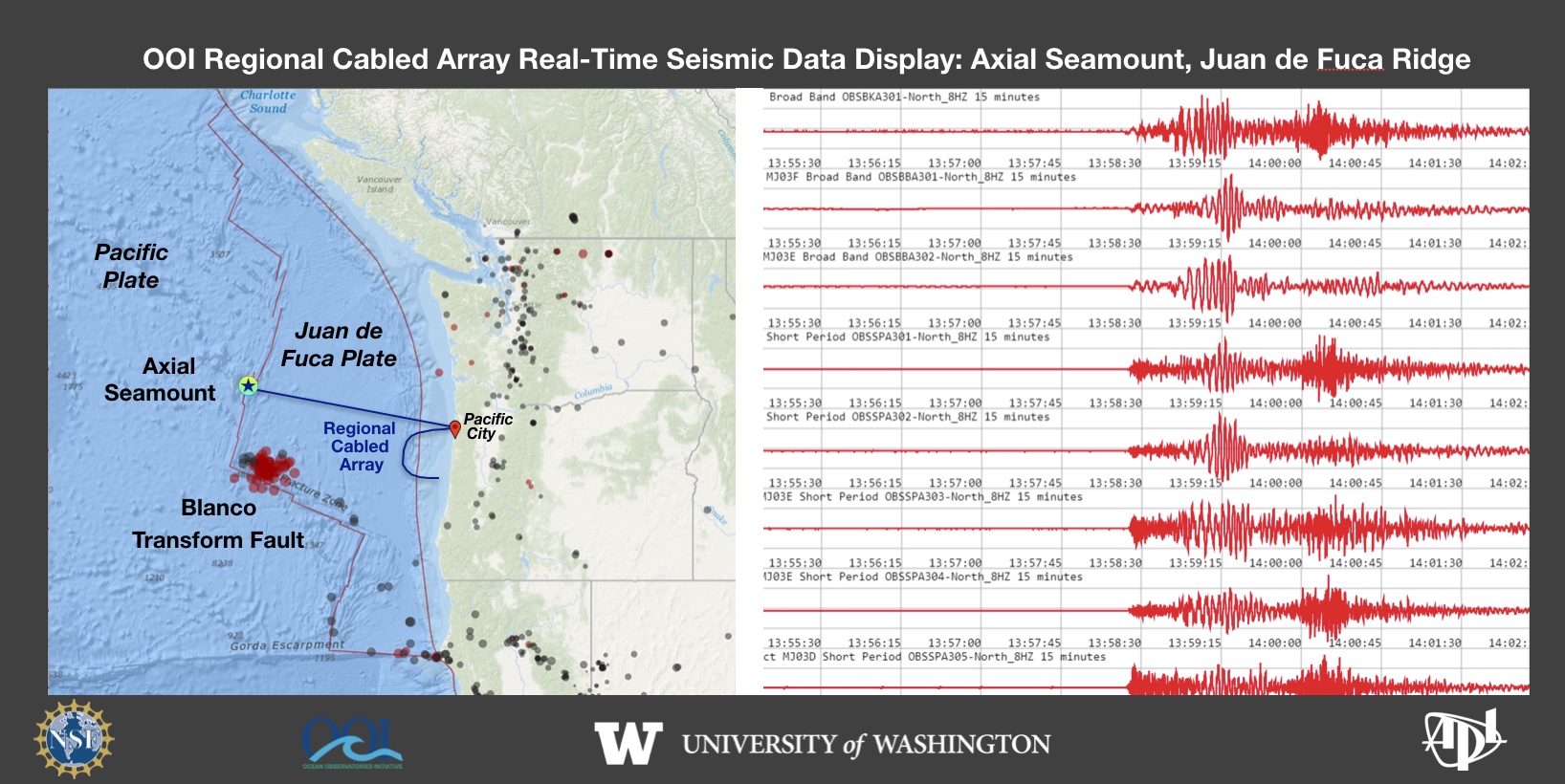 On December 7, 2021 a swarm of earthquakes began on the Blanco Transform Fault, a major plate boundary at the southern end of the Juan de Fuca Plate. The ongoing seismic swarm is being tracked live by the National Science Foundation’s underwater observatory, the Regional Cabled Array (RCA). The RCA is a component of NSF’s Ocean Observatories Initiative and is operated and maintained by the University of Washington. It includes ~900 km of high power and high bandwidth submarine fiber optic cables that stretch from Pacific City, OR out to the most active volcano off the coast “Axial Seamount” that erupted in 1998, 2011 and again in 2015. A second cable heads south along the Cascadia Subduction Zone and turns east along the Cascadia Margin off Newport, OR. Over 150 instruments on the seafloor and on instrumented moorings provide real-time data flow to shore at the speed of light. A suite of seismometers at the summit of Axial Seamount lit up on December 7, 2021 as the seismic swarm began along the Blanco. This live feed was developed by the UW Applied Physics Laboratory.
Read More
Katie Bigham: From VISIONS Student to Co-Chief Scientist
Katie Bigham feels like her journey with the Ocean Observatories Initiative (OOI) has come full circle. She first visited Axial Seamount as a University of Washington (UW) School of Oceanography undergraduate participant on the Regional Cabled Array (RCA) VISIONS 2014 program when the underwater observatory was being installed. This summer, she returned to Axial Seamount on her seventh cruise, this time as a Co-Chief Scientist.
[media-caption path="https://oceanobservatories.org/wp-content/uploads/2021/10/Katie_V15_byLauren_DSC_0069.sm-copy-scaled.jpg" link="#"]Katie Bigham on the R/V Thomas G. Thompson. Credit: L. Kowalski, University of Washington, V15.[/media-caption]Katie was excited to step into the role of Co-Chief Scientist on the fourth leg of the annual RCA operations and maintenance cruise (VISIONS’21). She previously participated in many other roles on the ship and was looking forward to a new challenge sailing as a Chief Scientist aboard a global class research ship.
Her responsibilities as Co-Chief Scientist included much planning and communication during the round-the-clock operations and numerous remotely operated vehicle dives. “It’s really about keeping everybody who’s invested in the voyage up to date, from the RCA team itself, to the Captain and crew, to the VISIONS’21 students, to the RCA team shore-side,” she says. Katie credits the success of leg four to the OOI RCA team aboard the R/V Thomas G. Thompson and strong shore support. “I felt well-supported in my first time as Co-Chief, and that helped me step up to the challenge,” she says.
Katie says the coolest part of being on the cruise was working with recent UW graduate Katie Gonzalez. She met the younger Katie when she went to visit her school for an outreach event in the far western reaches of the Olympic Peninsula and later mentored her in the lab for a year. “To see her very confidently and competently prepping the osmotic fluid samplers and then sharing with the ROV pilots what the goals of the installation dive were, and what was needed for this instruments deployment within and active vent site was really cool,” she says.
Katie Bigham grew up as the granddaughter of a commercial fisherman and spent a lot of time on the water, but she didn’t know that oceanography was something people studied until high school, when she interned with an oceanography graduate student at UW. The lab was very welcoming to her, and she attended the lab’s summer barbecues and dissertation defenses in between her work helping to culture Arctic bacteria.
After that experience, Katie initially wanted to study geology at Arizona State University, but she decided to stay closer to home and attend UW instead. When she remembered how welcoming the oceanography lab was, she decided to take oceanography classes, and that’s when things started coming together. Early in her college career, Katie took Dr. Deb Kelley’s hydrothermal vents class and came away from it wanting to see the underwater hot spring environments in person and work with Dr. Kelley and the OOI team.
“Deb bringing me onboard as a VISIONS student and then mentoring me through that process was what helped me know I wanted to stay in oceanography,” Katie explains. “I was really inspired by her research and her work with students, and I’d really like to continue in academia because of her influence. I wouldn’t be doing the things I’m doing without all her support.”
[media-caption path="https://oceanobservatories.org/wp-content/uploads/2021/10/20210903_100228_01-scaled.jpg" link="#"]VISIONS’21 Leg 4 students and participants. Credit: M. Elend, University of Washington, V21.[/media-caption]Katie is currently pursuing a joint PhD at the Victoria University of Wellington and the National Institutes of Water and Atmospheric Research in New Zealand. She is continuing with deep-sea science, researching the impact of turbidity currents, or underwater landslides, on benthic communities living in submarine canyons. This work builds on some of the work she did for her undergraduate senior thesis mapping megafauna at methane seeps along the RCA. Katie hopes that her research will be helpful for management of marine protected areas in New Zealand and inform about impacts in other marine canyons, such as those on the Cascadia Margin.
Katie returned to Washington from New Zealand during the COVID-19 pandemic. She has been able to continue her writing and data analyses while abroad from an office within the RCA space. Ironically, thanks to the pandemic, she was able to participate in this year’s RCA cruise.
After she obtains her PhD, Katie hopes to continue her research as a postdoc. “I would really like to bring what I’ve learned during my PhD and my experiences with the RCA back together,” she comments. “I’d love to do a postdoc working with RCA data.”
[embed]https://youtu.be/_YOsgNNLOP8[/embed]
Katie Bigham also played an instrumental role in the production of this video that was a project for the VISION’14 class. It was selected as one of the top ten videos in a nationwide contest sponsored by the Florida Center for Ocean Sciences Education Excellence. The video has been viewed by nearly 38,000 student judges in 1,600+ classrooms in 21 countries.
Read More
From Whale Songs to Volcanic Eruptions: OOI’s Cable Hears the Sounds of the Ocean
Sound is omnipresent in the ocean. Human-induced noise has the potential to affect marine life.
After the global recession in 2008, the ocean became quieter as shipping declined. Off the coast of Southern California, for example, scientists at Scripps Institution of Oceanography found that noise amplitudes measured from 2007-2010 were lowered by 70 percent with a reduction in one ship contributing about 10 percent.
A similar quieting of the ocean can be expected as global ship traffic continues its decline in response to the corona virus pandemic. This quieter ocean offers scientists ways to expand their ongoing research on ocean sound and its impact on marine life.
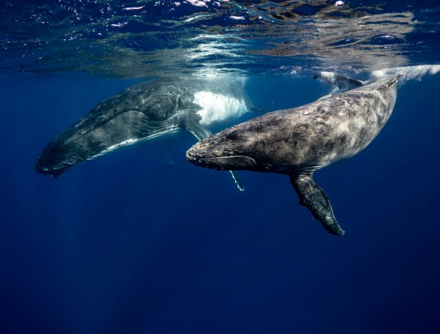
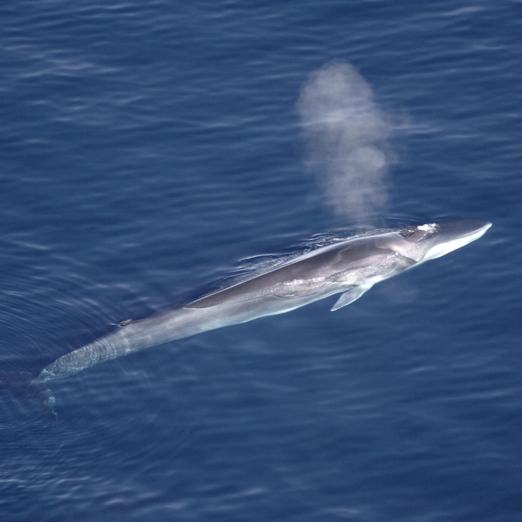
[media type="image" path="https://oceanobservatories.org/wp-content/uploads/2020/04/Finhval_1.jpg" link="#" alt="Fin Whale"][/media]“It takes time to document real change in the ocean, but University of Washington oceanographers have reported that over the past decade, fin whales have been communicating more softly in the Pacific,“ said Deborah Kelley, professor of oceanography at the University of Washington and director of the OOI’s Regional Cabled Array (RCA) component. “A quieter ocean allows us to hear more clearly life and other natural processes within the ocean.”
Years of listening to whales
John Ryan, a biological oceanographer at the Monterey Bay Aquarium Research Institute (MBARI), has been “listening in” on whales and other marine creatures since 2015 using a hydrophone on the Monterey Accelerated Research System (MARS), a cabled observatory, which was in part established as a test bed for the OOI Regional Cabled Array. Ryan and colleagues studied the occurrence of humpback whale (Megaptera novaeangliae) song in the northeast Pacific using three years of continuous recordings off the coast of central California.
[media type="image" path="https://oceanobservatories.org/wp-content/uploads/2020/04/Humpback_Whale_underwater_shot.jpg" link="#" alt="Humpback Whale"][/media]“We’ve been listening almost continuously since July 28, 2015, using a broadband, digital, omnidirectional hydrophone connected to MARS. Listening continuously for that long at such a high sample rate is not easy; only by being connected to the cable is this possible,” explained Ryan.
The researchers were able to discern whale songs from the busy ocean soundscape in Monterey Bay National Marine Sanctuary, which is a feeding and migratory habitat for humpback whales. The humpbacks’ song was detectable for nine months of the year (September–May) and peaked during the winter months of November through January. The study revealed strong relationships between year-to-year changes in the levels of song occurrence and ecosystem conditions that influence foraging ecology. The lowest song occurrence coincided with anomalous warm ocean temperatures, low abundances of krill – a primary food resource for humpback whales, and an extremely toxic harmful algal bloom that affected whales and other marine mammals in the region. Song occurrence increased with increasingly favorable foraging conditions in subsequent years.
Because the hydrophone is on the cabled observatory, its operation can be adjusted to achieve new goals. For example, the sampling rate of the hydrophone was doubled during an experiment that successfully detected very high frequency echolocation clicks of dwarf sperm whales (with Karlina Merkens, National Oceanic and Atmospheric Administration). “And that’s a beautiful aspect of being on the cable,” added Ryan. “Not only do we know that it is working, we catch any network glitches pretty quickly so we don’t lose data, and we can do real-time experiments like these.”
William Wilcock of the University of Washington and his students have compiled a decade worth of data on fin whales in the northern Pacific. Fin whales call at about 20 HZ, which is too low of a frequency for humans to hear, but perfect for seismometers to record. The researchers aggregated ten years of data from both temporary recorders and now permanent RCA hydrophones and seismic sensors and looked at the frequency of the calls and calling intervals. The researchers found both have changed over time.
The fin whales call seasonally and the frequency of the calls has gone down with time.
[audio mp3="https://oceanobservatories.org/wp-content/uploads/2020/04/Fin_whale_10x.mp3"][/audio]Calls peak in late fall, early winter in relation to mating season. Gradually through the season the frequency decreases. At the start of the next season, the call frequency jumps up again, but not quite to where it was the year before. Over ten years, the frequency has gone down about 2 HZ, and scientists are puzzled as to why this is occurring. It is unlikely to be due to increasing ship noise, because this lower sound frequency is getting closer to the range of the noise level of container ship propellers, about 6-10 HZ.
In some settings, ship noise is known to affect whale behavior and the permanent network of hydrophones operated by the OOI and Ocean Networks Canada will provide an opportunity to study whether whales are avoiding the shipping lanes to Asia.
Volcanoes also rumble in the deep
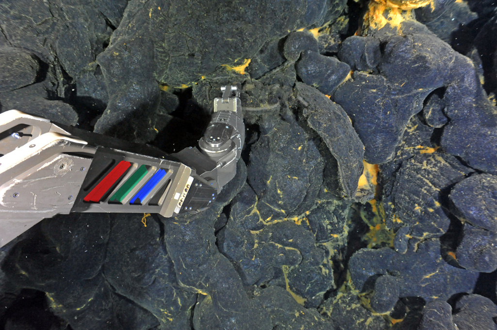
Whale sounds are but one of many acoustic signals being recorded and monitored using hydrophones and broadband seismometers. The OOI’s RCA off the Oregon Coast includes 900 kilometers (~560 miles) of submarine fiber-optic cables that provide unprecedented power, bandwidth, and communication to seafloor instrumentation and profiler moorings that span water depths of 2900 m to 5 m beneath the ocean surface. Using a suite of instruments connected to the cable, which continuously stream data in real time, scientists are listening in on the sounds of submarine volcanism, which accounts for more than 80 percent of all volcanism on Earth.
More than 300 miles off the Oregon coast in 1500 meters of water, 20+ cabled seafloor instruments are located at the summit of Axial Seamount, the most active volcano on the Juan de Fuca Ridge, including hydrophones and seismometers, which can also record sounds in the ocean.
“Scientists were able to hear(as acoustic noises traveling through the crust) >8000 earthquakes that marked the start of the Axial eruption in 2015. Coincident with this seismic crisis bottom pressure tilt instruments showed that the seafloor fell about 2.4 meters (~8 feet).
[video width="670" height="384" m4v="https://oceanobservatories.org/wp-content/uploads/2020/04/Axial-seamount-audio-.m4v"][/video]It was a remarkable collaborative event with scientists from across the country witnessing the eruption unfold live,” added Kelley. Such real-time documenting of an eruption in process was possible because of how Axial is wired. It is the only place in the oceans where numerous processes taking place prior to, during, and following a submarine eruption are captured live through data streaming 24/7. William Wilcock, University of Washington, and Scott Nooner, University of North Carolina, Wilmington, and colleagues reported these findings in Science, 2016.
Data collected from the hydrophones at the seamount’s base supported another discovery about Axial, indicating that it explosively erupted in 2015. Hydrophones recorded long-duration diffusive signals traveling through the ocean water consistent with explosion of gas-rich lavas, similar to Hawaiian style fissure eruptions. Follow-on cruises documented ash on some RCA instruments, again indicating the likelihood of explosive events during the 2015 eruption.
“Having the opportunity to listen in while a submarine volcano is active offers a really interesting window into things,” said Jackie Caplan-Auerbach, associate dean at Western Washington University and lead author of a G-cubed article that reported the possible eruptive findings. “While we cannot say with utter certainty that there were explosions at Axial, there’s a lot of evidence that supports this. We know from having listened to other eruptions that this was the same type of sound. It’s distinct, like the hissing sound of a garden hose on at top speed. We also found these really fine particulates, which could only have resulted from an eruption, had collected on one of the instruments at the site.”
[audio wav="https://oceanobservatories.org/wp-content/uploads/2020/04/axial_explosive.wav"][/audio]Added Caplan-Auerbach, “My favorite part of having OOI is it offers an ability for pure discovery. Its real time nature makes it possible to observe and see what happens. And sometimes the planet just hands you a gift that you didn’t expect. Not always being hypothesis driven is a very valuable aspect of science that I hope does not get lost. I’m very appreciative of projects like this that open our eyes into signals that we didn’t know were there.”
More opportunities to expand knowledge about sound and the sea are on the horizon. The US. Navy has funded Shima Abadi, University of Washington, Bothell, for a comprehensive study of sounds recorded by the OOI hydrophones. Stay tuned!
Image credits: Top fin whale: Wikipedia, Aqqa Rosing-Asvid – Visit Greenland. Second from top: humpback whale: Public domain, National Oceanic and Atmospheric Administration.
Read More
OOI Team First to See April 24, 2015 Eruption of Axial Seamount
At 7:33 p.m. PST on July 26th, 2015, after descending ~1840 m beneath the oceans surface, the remotely operated vehicle ROPOS and the University of Washington OOI Cabled Array team set first eyes on the April 24th, 2015 voluminous eruption of Axial Seamount during the VISIONS’ 15 cruise.
Read More