
Posts by ooistaff
Glider Observations Provide Insight into Spatial Patterns in Satellite Bio-Optical Measurements
From Henderikx et al., 9 February 2018
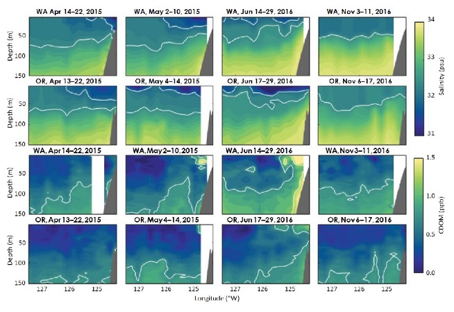
Hendrikx Freitas et al., 2018 compare satellite and Endurance Array glider estimates of chromophoric dissolved organic matter (CDOM) to characterize seasonal patterns and latitudinal and cross-shore gradients in particle concentrations between the Washington and Oregon shelves. While the Oregon and Washington shelves are both highly productive regions of the northern California Current Ecosystem, there are significant differences in the physical processes, with the central Washington shelf generally subject to weaker upwelling and a stronger Columbia River influence. The difference in physical forcing is reflected in satellite estimates of chlorophyll, which show higher concentrations off the Washington coast.
The conclusions from satellites contrast with in situ observations from gliders. Despite the differences in physical forcing, Henderikx et al., 2018 find OOI glider fluorescence based measurements of chlorophyll to be similar in magnitude across the Oregon and Washington shelves. Their research suggests that latitudinal differences in CDOM may be a partial explanation for perceived trends in satellite-derived chlorophyll. The OOI gliders gather simultaneous chlorophyll and CDOM fluorescence from an integrated three-channel sensor. While the glider observations indicate similar levels of chlorophyll fluorescence, they also show an increased presence of suspended sediments and CDOM off WA. The OOI observations, although temporally limited, indicate potential contamination of satellite retrievals of chlorophyll due to CDOM and suspended materials in the water column, particularly off the WA shelf, that should caution further attribution of satellite chlorophyll signals to differences in production.
Read MoreAxial Seamount: First Volcano Where a Submarine Eruption May Be Predicted
Wilcock et al., 16 December 2016
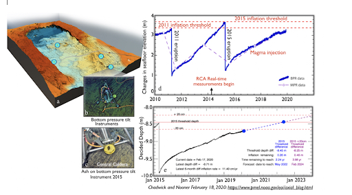
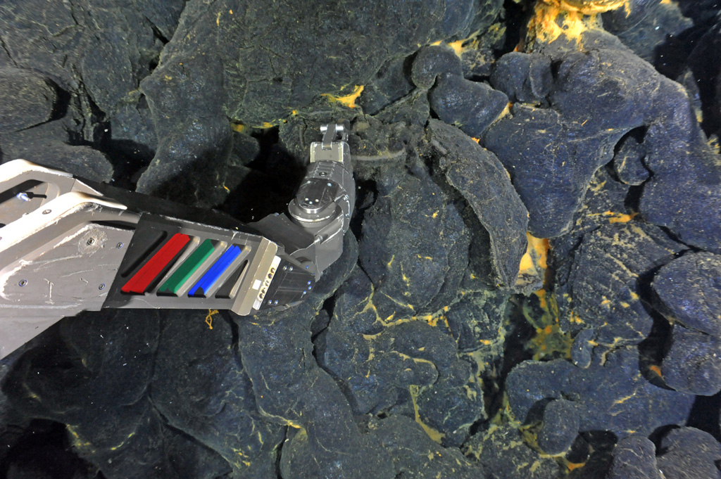
Axial Seamount was chosen as a key site on the Regional Cabled Observatory because it is the most active volcano on the Juan de Fuca Ridge having erupted in 1998, 2011, and 2015 [1-7] and because it has a long history of observations as the site of the first submarine volcanic observatory “NeMO” [1-2; https://www.pmel.noaa.gov/eoi/nemo/index.html]. Axial is also unique because the structure of microbial communities has been examined for over 2 decades, including prior to and immediately following the eruptions [8-11]. Nearly continuous seafloor deformation measurements began in 1998 using battery-powered bottom pressure recorders (BPR’s), augmented by mobile pressure recorders in 2000 [3,12-14]. In 2014, an array of cabled bottom pressure tilt instruments, developed by Chadwick [13,14], were installed within the caldera providing real-time measurements of seafloor inflation caused by magma injection in the subsurface and extremely rapid deflation events coincident with eruptions and draining of the magma chamber [13,14]. In concert, these measurements, coupled with modeling, provide forecasting of when the next eruption may occur [13,14; https://www.pmel.noaa.gov/eoi/axial_blog.html].
The ability to make such forecasts is rare in both terrestrial and submarine environments, however, they are possible at Axial due to the continuous magma supply from the Cobb hotspot plume [12-14]. The subsurface structure of Axial is the best imaged submarine volcano due to multiple seismic imaging programs. In concert, these field programs have resulted in 3-D tomographic imaging of the magmatic system [15-20], providing unparalleled insights into melt distribution and magma flux, which controls seafloor deformation. Two large magma bodies at 1.1 to 2.6 km beneath the seafloor [15-18] and a newly recognized deep 3-5 km wide conduit located 6 km beneath the seafloor have been imaged [18]. The conduit is interpreted to contain a series of stacked melt lenses (sills) with spacings of 300-450 meters, providing melt transport that activated the eruptions in 1998, 2011, and 2015 [18]. The 22-year monitoring of Axial Seamount by Chadwick and Nooner document co-eruption deflation events in the caldera of 2.5-3.2 meters, followed by variable periods of inflation [14]. Based on the long-term time series, the 2015 eruption was forecast within a 1-year time window, seven months in advance of the eruption [14]. Daily updates are provided by the model, and coupled with real-time seismic measurements [e.g. 21], will allow refinement of when the next eruption will occur.
[blockquote][1] Embley Jr., R.W., Chadwick, W.W., Clague, D., and Stakes, D., (1999) The 1998 Eruption of Axial Volcano: multibeam anomalies and seafloor observations. Geophysical Research Letters, 26, 2428– 3425.
[2] Embley, R.W., Baker, E.T., (1999) Interdisciplinary group explores seafloor eruption with remotely operated vehicle. Eos Trans. AGU, 80, 213, 219, 222.
[3] Chadwick, W.W., Jr., Nooner, S.L. Zumberge, M.A.. Embley, R.W., Fox, C.G. (2006) Vertical deformation monitoring at Axial Seamount since its 1998 eruption using deep-sea pressure sensors. Journal of Volcanology and Geothermal Research, 150, 323-327.
[4] Chadwick, W.W., Jr., Paduan, J.B., Clague, D.A., Dreyer, B.M., Merle, S.G. Bobbitt, A.M. Bobbitt, Caress, D.W. Caress, Philip, B.T., Kelley, D.S., and Nooner, S. (2016) Voluminous eruption from a zoned magma body after an increase in supply rate at Axial Seamount. Geophysical Research Letters, 43, 12,063-12,070; https://doi.org/10.1002/2016GL071327.
[5] Caress, D. W., Clague, D. A. Paduan, J. B., Martin, J. F., Dreyer, B. M., Chadwick, W.W., Jr., Denny, A., and Kelley, D.S. (2012) Repeat bathymetric surveys at 1-metre resolution of lava flows erupted at Axial Seamount in April 2011. Nature Geoscience, 5(7), 483–488.
[6] Clague, D.A., Dryer, B.M., Paduan, J.B., Martin, J.F., Chadwick, W.W., Caress, D.W., Portner, R.A., Guilderson, T.P., McGann, M.L., Thomas, H., Butterfield, D.A., Embley, R.W. (2013) Geolgoica history of the summit of Axial Seamount, Juan de Fuca Ridge. Geochemistry Geophysics Geosystems, 14 (10), https://doi.org/10.1002/ggge.20240.
[7] Clague, D.A., Paduan, J.B., Caress, D.W., Chadwick, W.W., Jr., Le Saout, M., Dreyer, B.M. and Portner, R.A. (2017) High-resolution AUV mapping and targeted ROV observations of three historic lava flows at Axial Seamount. Oceanography, 30(4), 82–99; https://doi.org/10.5670/oceanog.2017.426.
[8] Huber, J.A., Butterfield, D.A., and Baross, J.A. (2003) Bacterial diversity in asubseafloor habitiat following a deep-sea volcanic eruption. FEMS Microbiology Ecology, 43, 393-409.
[9] Opatkiewicz, A.D., Butt4erfield, D.A., and Baross, J.A. (2009) Individual hydrothermal vents at Axial Seamount harbor distinct subseafloor microbial communities. FEMS Microbiology Ecology, 70, 413-424. https://doi.org/10.1111/j.1574-6941.2009.0074.x.
[10] Meyer, J.L., Akerman, N.H., Proskurowski, G., and Huber, J.A. (2013) Microbial characterization of post-eruption “snowblower” vents at Axial Seamount, Juan de Fuca Ridge. Frontiers in Microbiology, doi.org/10.3389/fmicb.2013.00153.
[11] Spietz, R.L., Butterfield, D.A., Buck, N.J., Larson, B.L., Chadwick, W.W., Jr., Walker, S.L., Kelley, D.S. and Morris, R.M. (2018) Deep-sea volcanic eruptions create unique chemical and biological linkages between the subsurface lithosphere and the oceanic hydrosphere. Oceanography, 31, 128-135; doi.org/10.5670/oceanog.2018.120.
[12] Nooner, S.L., and Chadwick, W.W., Jr., (2009) Volcanic inflation measured in the caldera of Axial Seamount: Implications for magma supply and future eruptions. Geochemistry, Geophysics, Geosystems, 10(2), doi.org/10.1029/2008GC002315.
[13] Nooner, S.L., and Chadwick, W.W. Jr. (2016) Inflation- predictable behavior and co-eruption deformation at Axial Seamount. Science, 354, 1399-1403; https://science.sciencemag.org/content/354/6318/1399
[14] Chadwick, W.W., Jr., Nooner, S.L., and Lau, T.K.A. (2019) Forecasting the next eruption at Axial Seamount based on an inflation-predictable pattern of deformation. American Geophysical Union, Fall Meeting 2019, OS51B-1489.
[15] Arnulf, A. F., Harding, A. J., Kent, G. M., Carbotte, S. M., Canales, J. P., and Nedimovic, M. R. (2014) Anatomy of an active submarine volcano. Geology, 42(8), 655–658. https://doi.org/10.1130/G35629.1
[16] Arnulf, A.F., Harding, A.J., Kent, G.M., and Wilcock, W.S.D. (2018) Structure, seismicity and accretionary processes at the hot-spot influenced Axial Seamount on the Juan de Fuca Ridge. Journal of Geophysical Research, 10.1029/2017JB015131.
[17] Carbotte, S. M., Nedimovic, M. R., Canales, J. P., Kent, G. M., Harding, A. J., and Marjanovic, M. (2008) Variable crustal structure along the Juan de Fuca Ridge: Influence of on-axis hot spots and absolute plate motions. Geochemistry, Geophysics, Geosystems, 9, Q08001. doi.org/10.1029/2007GC001922.
[18] Carbotte, S.M., Arnulf, A., Spiegelman, M., Lee, M., Harding, A., Kent, G., Canales, J.P., and Nedimovic, M., Stacked sills forming a deep melt-mush feeder conduit beneath Axial Seamount. Geology, 48, (7) 693-697. https://doi.org/10.1130/G47223.1.
[19] West, M., Menke, W., and Tolstoy, M. (2003) Focused magma supply at the intersection of the Cobb hotspot and the Juan de Fuca ridge. Geophysical Research Letters, 30(14), 1724. https://doi.org/10.1029/2003GL017104.
[20] West, M., Menke, W., Tolstoy, M., Webb, S., and Sohn, R. (2001). Magma storage beneath Axial volcano on the Juan de Fuca mid-ocean ridge. Nature, 413(6858), 833–836. doi.org/10.1038/35101581.
[21] Wilcock, W.S.D., Tolstoy, M., Waldhauser, F., Garcia, C., Tan, Y.J., Bohnenstiehl, D.R., Caplan-Auerbach, J., Dziak, R., Arnulf, A.F., and Mann, M.E. (2016) Seismic constraints on caldera dynamics from the 2015 Axial Seamount eruption. Science, 354, 1395-399;
https://doi org/10.1126 /science.aah5563.
[/blockquote] Read More
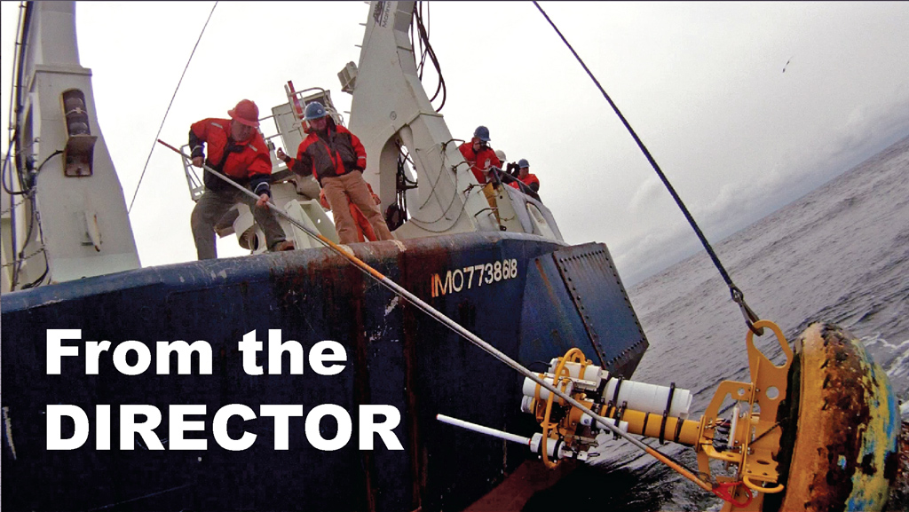
Successful Turn of the Irminger Sea Array
The 2015 Irminger Sea Array cruise marked the first “turn” (recovery & reinstallation) of the moorings and gliders as well as a first look at the data collected during the first year.
Read More2015 Cabled Array Cruise, A Success for OOI Infrastructure and Scientific Discovery
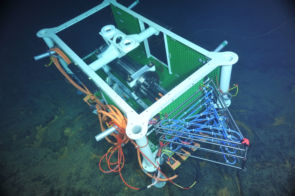
The 2015 Cabled Array cruise marked the completion of installation at the Cabled Array, provided a first look at the April 2015 Axial eruption site, and led to the discovery of a new seep site on the continental slope.
On August 7th, the OOI Cabled Array team, along with 21 students and the remotely operated vehicle ROPOS, completed installation of the OOI Cabled Array, as well as its first maintenance cruise. A total of 118 instruments are now streaming data from the Juan de Fuca plate through 540 miles of fiber-optic cable to shore.
The R/V Thompson set sail on July 4th from the University of Washington on a 3-Leg, 35-day cruise with the objective to 1) deploy Deep Profiler Moorings on the continental slope, at the slope base off of Oregon, and at the base of Axial Volcano and 2) recover and reinstall junction boxes, mooring science pods, and instruments at the 6 cabled study sites comprising the Cabled Array. Over the course of the cruise, 13 platforms and 112 instruments were installed and ROPOS completed 55 dives. (more…)
Read MoreThe Plan To Create A ‘Fitbit For The Oceans’
This fall, an integrated infrastructure of sensor systems will sprawl, swim, and anchor itself across our oceans as part of the Oceans Observatories Initiative, a project 10 years in the making.
Read MoreOOI Construction and Data Status Update: August 14, 2015
OOI Construction and Data Status Update: August 14, 2015
Read MoreOOI Team First to See April 24, 2015 Eruption of Axial Seamount
At 7:33 p.m. PST on July 26th, 2015, after descending ~1840 m beneath the oceans surface, the remotely operated vehicle ROPOS and the University of Washington OOI Cabled Array team set first eyes on the April 24th, 2015 voluminous eruption of Axial Seamount during the VISIONS’ 15 cruise.
Read MoreStation Papa Array Annual Maintenance and Profiling Glider Deployment
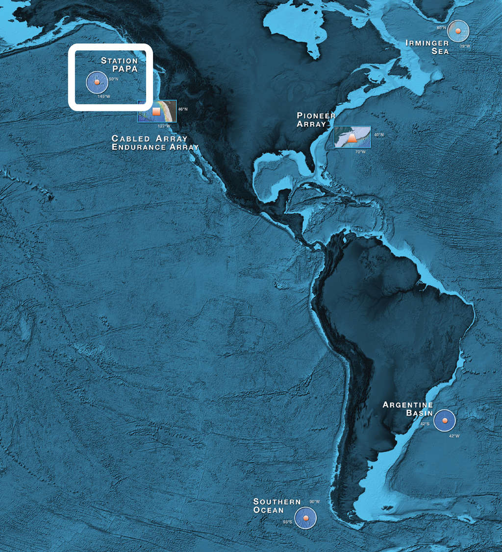
The Ocean Observatories Initiative (OOI) team in June 2015 conducted deployment and scheduled maintenance activities for the global component of the OOI infrastructure located in the Station Papa site, in the Gulf of Alaska.
Read MoreAxial Eruption Site Identified – Bathymetric Survey Data Available Online
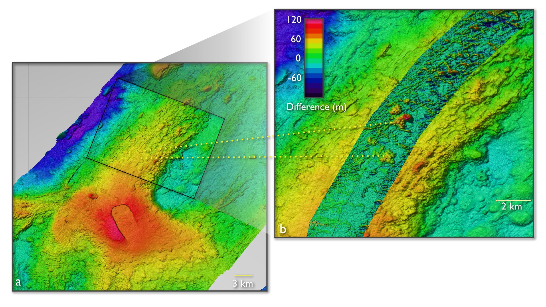
On April 24th, 2015, the Axial Volcano, situated on the Juan de Fuca plate 300 miles offshore, erupted one-mile deep in the ocean and we saw it.
Read MoreOOI Construction and Data Status Update: July 19, 2015
The OOINet Build 5.1 integrated solution is working, pulling data through the uFrame software for visualization in the user interface, with Alpha I Testing completed on June 21.
Read More